Bry john (15 Ergebnisse)

- Softcover
Anbieter: Revaluation Books, Exeter, Vereinigtes KönigreichRevaluation Books
Verkäufer/-in kontaktierenVerkäufer/-in mit 5 SternenZustand: Neu
EUR 23,31
EUR 14,66 VersandVersand von Vereinigtes Königreich nach USAAnzahl: 1 verfügbar
Paperback. Zustand: Brand New. 380 pages. 11.00x8.50x0.96 inches. In Stock. White, Governor John; De Bry, Theodor (illustrator).

- Softcover
Anbieter: Ria Christie Collections, Uxbridge, Vereinigtes KönigreichRia Christie Collections
Verkäufer/-in kontaktierenVerkäufer/-in mit 5 SternenZustand: Neu
EUR 25,48
EUR 14,05 VersandVersand von Vereinigtes Königreich nach USAAnzahl: Mehr als 20 verfügbar
Zustand: New. In.
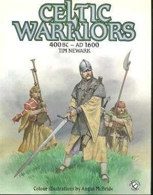
Celtic warriors, 400 BC-1600 AD. [The Golden Age : Celtic Europe Against the Greeks & Romans; The Battle for Britain : Celtic Britain Against the Anglo-Saxons; Northern Menace : Ireland & Britain Against the Vikings & Normans; Welsh & Scots; etc]
Newark, Timothy. [colour illustrations by Angus McBride; artwork, John Thompson, Alphonse de Neuville, Theodor de Bry, William B Scott, Edward Gascoine]
Sprache: Englisch
Verlag: Poole, Dorset ; New York : Blandford Press ; New York, NY : Distributed in the U.S. by Sterling Pub. Co., 1986., 1986
- Hardcover
Anbieter: Joseph Valles - Books, Stockbridge, GA, USAJoseph Valles - Books
Verkäufer/-in kontaktierenVerkäufer/-in mit 5 SternenZustand: Gebraucht - Gut
EUR 28,86
EUR 14,84 VersandVersand innerhalb von USAAnzahl: 1 verfügbar
Hardcover. Zustand: Very Good. Zustand des Schutzumschlags: Very Good. 144 p., [16] pp. of plates ; illustrated with photographs, drawing, reproductions of 19th century engravings and color plates ; 26 cm. ; ISBN: 0713716908; 9780713716900 LCCN: 86-197211 ; LC: U805; Dewey: 940/.04916 ; OCLC: 14378232 ; green cloth wit h gold le…ttering in color pictorial dustjacket ; ownership stamp on flyleaf ; mark from a store label on front ep ; "Such a survey of the long and furious struggle of the Celts against Roman, Germanic, Norse and English conquerors has never before b een produced. Tim Newark's vision of Celtic warfare from the point of view of the Celts is unique."-- dustjacket ; VG/VG. Book.

- Softcover
Anbieter: Ria Christie Collections, Uxbridge, Vereinigtes KönigreichRia Christie Collections
Verkäufer/-in kontaktierenVerkäufer/-in mit 5 SternenZustand: Neu
EUR 28,98
EUR 14,05 VersandVersand von Vereinigtes Königreich nach USAAnzahl: Mehr als 20 verfügbar
Zustand: New. In.

The New World: The First Pictures of America; with contemporary narratives of the Huguenot Settlement in Florida 1562-1565 and the Virginia Colony 1585-1590
LORANT, Stefan (editor; annotations); John White and Jacques Le Moyne (made by); Theodore De Bry (engraved by)
Verlag: Duell, Sloan, & Pearce, New York, 1946
- Erstausgabe
Anbieter: Lorne Bair Rare Books, ABAA, Winchester, VA, USALorne Bair Rare Books, ABAA
Verkäufer/-in kontaktierenVerkäufer/-in mit 5 SternenZustand: Gebraucht
EUR 49,60
EUR 5,69 VersandVersand innerhalb von USAAnzahl: 1 verfügbar
First Edition. Quarto (31cm); gray cloth-covered boards with blocking in red, and titling stamped in gilt, on spine and front cover; publisher's slipcase; 292pp; colorful and black-and-white illustrations. Light shelf-wear, with soil to spine and lower edge of textblock; Very Good. Publisher's slipcase has paper title label, mod…est shelf-wear and -soil, and peeling to paper along edges; Good. Includes early accounts of America, with many illustrations throughout. [89555].

Cavalier de La Salle l'expedition de 1684 La Belle
Boudriot, Jean avec John de Bry, Jean Claude Lemineur et James E.Bruseth, Layne Hedrick
Sprache: Französisch
Verlag: Collection Archeologie Navale Francaise, Paris, 2000
- Hardcover
- Erstausgabe
Anbieter: WORLD WAR BOOKS, TUNBRIDGE WELLS, Vereinigtes KönigreichWORLD WAR BOOKS
Verkäufer/-in kontaktierenVerkäufer/-in mit 5 SternenVerbandsmitglied: PBFA
Zustand: Gebraucht - Gut
EUR 102,67
EUR 15,07 VersandVersand von Vereinigtes Königreich nach USAAnzahl: 1 verfügbar
Hardcover. Zustand: Very Good. Zustand des Schutzumschlags: Very Good. 1st Edition. Hardback. Excellent reference on La Belle 1684. 1st Edition 2000. French text. 160pp., numerous ills., including full colour, maps, plans etc. Copy belonged to David Roberts who produced most of the English translations of these excellent books a…nd he has made a few neat ink number changes to pages as he was planning his English version. Also seperately are a number c.15) of the English translated pages. Overall very good in like dustwrapper. Heavy book.

- Softcover
Anbieter: BUCHSERVICE / ANTIQUARIAT Lars Lutzer, Wahlstedt, DeutschlandBUCHSERVICE / ANTIQUARIAT Lars Lutzer
Verkäufer/-in kontaktierenVerkäufer/-in mit 5 SternenZustand: Gebraucht - Gut
EUR 449,90
EUR 39,95 VersandVersand von Deutschland nach USAAnzahl: 1 verfügbar
Softcover. Zustand: gut. Floride, un rêve français (1562-1565) pages.
Verlag: New York : Crown Publishers, 1941, 1941
- Hardcover
Anbieter: Joseph Valles - Books, Stockbridge, GA, USAJoseph Valles - Books
Verkäufer/-in kontaktierenVerkäufer/-in mit 5 SternenZustand: Gebraucht - Befriedigend
EUR 139,78
EUR 14,84 VersandVersand innerhalb von USAAnzahl: 1 verfügbar
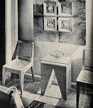
Hardcover. Zustand: Good. No Jacket. 2nd Edition. xi, 356 pages : illustrations ; 29 cm ; LCCN: 41-10057 ; LC: NK2230; Dewey: 749 ; OCLC: 813523 ; "Revised, February, 1941" ; dull orange cloth with brown lettering ; no dustjacket ; Contents: Part I. The development of decoration. Introductory ; Italy ; Spain ; France ; France: a…fter Louis XIV ; England ; England : the age of walnut ; England : the age of mahogany ; England : the age of satinwood ; The nineteenth century ; Early American ; The Federal Period and after ; The twentieth century ; Contemporary design -- Part II. The elements of decoration. Materials of decoration ; Fabrics ; Wall coverings ; Floor coverings ; Decorative objects ; Color ; Lighting ; Windows and window treatment ; Furniture and how to buy it -- Part III. The principles of decoration. Room planning and arrangement ; Rooms ; Seasonal change. ; numerous black and white plates ; drawings ; each architect, designer and photographer is indicated, and includes work by Alexander H Girard, Bassett & Vollum, Ruth Campbell Bigelow, Richard Averill Smith, F S Lincoln, Sarah Hunter Kelly, Hubert Robert, Douglas Sommerville, M Therese Bonney, Nancy McClelland, Mattie Edwards Hewitt, Arthur S Vernay, H Leo Gould, William Helburn, Katherine Park Studdiford, Paul J Woolf, Ralph Steiner, Joseph Mullen, Felix Augenfeld, Richard Garrison, Gilbert Rohde, William Lescaze, Paul Bry, William Muschenheim, Joseph Allen Stein, Calvert Coggeshall, John Funk, Richard Neutra, Alvar Aalto, Edward Stone, Dan Cooper, Roy Barley, Kurt Schelling, Frank Randt, Ida Webster, Lucille Schlimme, Margery Sill Wickware, Edna Kern, Harrie Lindeberg, Tommi Parzinger, William Lescaze, Morris Sanders, James F Eppenstein, Virginia Conner, Gottscho, Paul MacAlister, Harwell Hamilton Harris, Harold Costair, Verna Cook Solomonsky, Ethel A Reeve, Van Anda, Evans Moore, Robsjohn-Gibbings, Sylvia Holt, Paul Laszlo, Fred R Dapprich, and Drix Duryea ; great industrial and interior photography; also features 1930's and 1940's art deco, 1950's populux and madcap designs ; sunned , name on front endpaper ; foxing, spot on cover ; else G. Book.
 Weitere Bilder
Verlag: Theodore de Bry, 1590
- Hardcover
- Erstausgabe
Anbieter: Lule A Vavra Rare Maps and Books, Chester, VA, USALule A Vavra Rare Maps and Books
Verkäufer/-in kontaktierenVerkäufer/-in mit 4 SternenZustand: Gebraucht - Gut
EUR 59.969,84
Versand nach gratisVersand innerhalb von USAAnzahl: 1 verfügbar
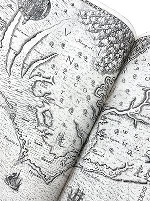
Hardcover. Zustand: Very Good. No Jacket. 1st Edition. "----PUBLICATION DETAILS: Published in 1590 by Theodore de Bry in Frankfurt, Germany. Printed by Johann Bechel. First edition. Map is State 3 of 3. ----RARITY: QUOTE: Nothing is more rare than the first editions of these four parts [Parts I. IV in German]. Bibliotheca Grenvi…lliana, I: 89 END QUOTE. (Church, p. 429).The Bibliotheca Grenvilliana was published in London in 1842. To bring this up to date, there are 15 entries on the ABE Book site for de Bry s Grand Voyages America series; none is the German 1st edition, Part I. It is not to be found in the Rare Book Hub register or on the internet. ----NOTE: The major components of Part I are listed below. Missing elements are identified. ----MISSING THE ENGRAVED TITLE PAGE: Wunderbarliche, doch warhafnewlichftige Erklärung, von der Gelegenheit vnd Sitten der Wilden in Virginia ----INTRODUCTION PAGE: Warhafftige Contrafacturen Und Sebrauch der Innnivohner der jentgen Landschafft in America welche Virginia. Theodorum de Bry. In the English edition this reads The true pictures and fashions of the people in that part of America now called Virginia .Theodore de Bry . ----MISSING THE DEDICATION. ----RARE MAP OF VIRGINIA: Americae pars, Nunc Virginia dicta primum ab Anglis inventa sumtibus Dn Walteri Raleigh Equestris ordinis Viri Anno Dni.M.D LXXXV . At left border: Autore Ioanne With Sculptore Theodoro de Bry, Qui et excud. Burden 76. The RARE THIRD STATE with the correct engraved C which is superimposed over faint images of the middle bar and the upper and lower extensions to the left of the original letter E. State 2 has a very dark letter C superimposed over the very dark letter E. The C over E were not completely hammered out and burnished before the new letter C was added. State 3 has been observed on one other map and compared to a State 2 to confirm the difference. The buyer will be provided the background material. ----TABLE OF CONTENTS: Register. Table of the 23 copper plates showing the map as I. Some writers erroneously call the Adam and Eve engraving Plate I. ----ADAM & EVE. Un-numbered full-page plate showing Adam standing, looking up, as Eve reaches for an apple from the tree of knowledge. No title or text is provided. FIRST STATE with the inscription "Iodocus a Winghe in / Theodore de Bry fe" at the bottom. For more about the States, see Vavra, listed in the Bibliography. ----MISSING TEXT. Lacks the text by Thomas Hariot, which he published id in 1588. ----NUMBERED ENGRAVINGS. Copper engravings numbered with Ronan numerals II through XXIII, except plates XIII, XVII. XVIII. XIX, XX, and XXII are full-page and numbered in image with Arabic numerals only. Most are based on John White s watercolors from his time with the Roanoke Colony. ----THE PICTS. Etliche contrafeyt der Volcker, genannt Picten, die vorzeiten einen Kreyss in engellandt jnngehabt haben. Known as 'Picti' by the Romans, meaning 'Painted Ones' in Latin, the Picts lived in upperScotland during the late ancient and early medieval periods. The British Library indicates these engravings are after watercolors byJacques Le Moyne de Morgues. ----COLOPHON: Gedruckt zu Franckfurt am Mayn bey Johann Bechel in verlegung Theodori de Bry. MDXC. ----CONDITION: FIRST EDITION THROUGHOUT. Numbered engravings correlate fully with Church first German edition (No. 176). This volume does not have the ornate title page, the dedication or the text by Thomas Hariot. Recently conserved by reputable North Carolina firm. New full calf binding. A few pages have paper repairs, and the fold-outs were lined with Japanese paper. A few small stains. Very good condition. ----PREVIEW. For a detailed analysis of Part I and its images see Vavra, below. ----BIBLIOGRAPHY: ----Burden, Philip D. The Mapping of North America. Rickmansworth: Raleigh Publications, 1996; ----Church, Elihu Dwight. A Cataloguee of Books Relating to the discovery of North and South America. New York: Dodd, Mead and Company, 1907. [Number 176]] ----Vavra, Luke ".
 Weitere Bilder
Verlag: Theodori De Bry [Theodor De Bry], Francoforti [Frankfurt], 1590
- Hardcover
- Erstausgabe
Anbieter: Type Punch Matrix, Silver Spring, MD, USAType Punch Matrix
Verkäufer/-in kontaktierenVerkäufer/-in mit 5 SternenZustand: Gebraucht - Gut
EUR 45.090,10
Versand nach gratisVersand innerhalb von USAAnzahl: 1 verfügbar
Zustand: Very good plus. Mixed first and second issue. First edition of this iconic account of Virginia, the Roanoke colony, and its environs, including the landmark map of Virginia and all the famed engravings of Native American life in the 1580s. The first of De Bry's series of great and small voyages, this book is particularl…y important for its content on the lives of the Native American populations of Virginia and North Carolina in the late 16th century as recorded by a key member of an early expedition. Thomas Hariot, an English polymath fluent in Carolina Algonquin, penned the text on a voyage to Roanoke Island in 1585-6, including direct observations of the Indigenous populations' living arrangements, farming, fishing, and traditional practices. The text is accompanied by illustrations originally made by John White, a member of the same expedition and later famous for his discovery that the colony of Roanoke had vanished - the very colony described in detail here by Hariot. Copies of De Bry's voyages are known for causing "the greatest confusion of bibliographers" and "the despair of collectors" (Church, vol 1, 317) owing to their typically mixed and/or incomplete states. The first and second issues of part one of the voyages were issued in the same year and are largely uniform with only minor differences in the position of the text. As with the vast majority of known copies, the present copy contains plates from both issues, with six plates from the first issue and six from the second (where there are issue points to distinguish them; the remaining 19 plates are identical between issues), as well as a mix of the first two text issues and the map in its second state (as usual) as identified by Burden. Though lacking some leaves, this copy retains its complete set of the Native American plates, arguably the most important and informative part of the entire De Bry series, and the stellar map of Virginia. A foundational book for collectors of Americana. 14'' x 9.5''. Modern polished brown goat boards tooled in blind and gilt, light brown goatskin spine label. Red-stained edges. Endpapers renewed. Illustrated with engraved title page and 25 (of 28) engraved plates (two folding), and double-page map. 34, [64], [22] pages, most printed one side only; lacking leaves d6 (Adam & Eve plate), D6 (blank), E2 (Picts plate I), E6 (Picts plate III), and F6 (colophon). Leaves variously expertly repaired to margins, with occasional faint soil or dampstaining. Binding only a bit of faint scuffing, else solid and clean.
Verlag: Sterling Publishing House, Co., Inc, New York, 1960
- Erstausgabe
Anbieter: Between the Covers-Rare Books, Inc. ABAA, Gloucester City, NJ, USABetween the Covers-Rare Books, Inc. ABAA
Verkäufer/-in kontaktierenVerkäufer/-in mit 5 SternenZustand: Gebraucht - Gut
EUR 90,18
EUR 4,82 VersandVersand innerhalb von USAAnzahl: 1 verfügbar
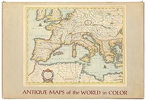
Unbound. Zustand: Very Good. Portfolio. Color facsimiles of 36 historical maps. Each map measures approximately 12" x 9", printed on 17" x 11½" paper with descriptive text in the left margin. Housed with a title page sheet and unprinted top sheet in a four-fold chemise. Unprinted topsheet sunned at the edges, first two leaves wi…th some very light toning and a couple of tiny corner creases; the maps are otherwise bright and fine. The chemise is good only with toning, wear, and soil, and a 1" creased tear on the cover panel. A nice production, and the chemise has done its job, keeping the maps bright and fresh.

La Belle, 1684. (Volume 1). La Belle, 1684. Recueil des Planches, 1730. Monographie de La Belle. (Volume 2). Collection Archéologie Navale Française.
BOUDRIOT, Jean. - BRY, John de (avec la collaboration de). - LEMINEUR, Jean Claude (avec la collaboration de). - BRUSETH, James E. (avec la collaboration de). - HEDRICK, Layne (avec la collaboration de).
Verlag: chez l'auteur, Paris,, 2000
Anbieter: Bouquinerie du Varis, Russy, FR, SchweizBouquinerie du Varis
Verkäufer/-in kontaktierenVerkäufer/-in mit 5 SternenZustand: Gebraucht
EUR 122,30
EUR 80,50 VersandVersand von Schweiz nach USAAnzahl: 1 verfügbar
320x240mm, 134pages, photos couleurs et n/b, (Volume 1) - (Volume 2): Sous portefeuille illustré, 20 planches n/b en feuilles, échelles 1/24, 1/36, 1/48 (collation: effectué). Très bel exemplaire. Envois Europe : Sans frais additionnels. TVA prélevée via IOSS & Envoi en DDP (droits payés). Exceptions (taxes postales locales à la… charge de l'acheteur) : France, Italie, Lituanie (~2EUR). Contact via notre page d'accueil en cas de problème. reliure d'éditeur sous jaquette.

Verlag: Theodore de Bry, 1590
- Karte
Anbieter: Lule A Vavra Rare Maps and Books, Chester, VA, USALule A Vavra Rare Maps and Books
Verkäufer/-in kontaktierenVerkäufer/-in mit 4 SternenZustand: Gebraucht - Gut
EUR 18.937,84
Versand nach gratisVersand innerhalb von USAAnzahl: 1 verfügbar
No Binding. Zustand: Very Good. MAP OF VIRGINIA. JOHN WHITE, 1590. RARE STATE. ----Americae pars, Nunc Virginia dicta primum ab Anglis inventa sumtibus Dn Walteri Raleigh Equestris ordinis Viri Anno Dni. M.D LXXXV. . ----TITLE TRANSLATION: Part of America, now called Virginia, first discovered by the English, taken up by Sir Wal…ter Raleigh, Knight, in 1585 A.D. ----PUBLICATION DETAILS: Published in Theodore de Bry, Wunderbarliche, doch warhafnewlichftige Erklärung, von der Gelegenheit vnd Sitten der Wilden in Virginia. (Frankfurt, 1590). A t the left border: Autore Ioanne With Sculptore Theodoro de Bry, Qui et excud. This acknowledges John White as the engraver, but a few plates were done in-house, from Cape Fear to the Chesapeake Bay. ----BACKGROUND: The story in this book containing g this map takes place beginning in 1585 on Roanoke Island in what is now Dade County, North Carolina. Queen Elizabeth (the First) had granted Sir Walter Raleigh a charter to colonize the part of America north of the Spanish claim for Florida. This new land was named Virginia in honor of the virgin queen. At the time of this book, Virginia covered the area from Maryland to the border of Florida. Raleigh appointed Ralph Lane as governor. Thomas Hariot was the documentarian and John White the surveyor (and cartographer). De Bry s book is based primarily on their work. Americæ pars, nunc Virginia covers the coast from Cape Fear to the Chesapeake Bay. It is the first separate map of Virginia and the first printed record of Raleigh s attempt to establish a colony in North America. ----Burden states: The map concerned depicts the area from Chesapeake Bay to Cape Lookout. It exhibits greater knowledge than on any of the surviving manuscripts. Possibly this is from knowledge gained during White's brief visit in 1587 and signifies some lost manuscripts. Here we find the first printed use of the name Chesapeake, Chesepiooc Sinus, and the second of Roanoke (the first being Mazza). It depicts the positions of the Indian villages in the area and is adorned with the Royal Arms of England. The Latter's ships are shown at sea with Indian canoes traversing the inland waters. The two native scenes shown are taken from illustrations in the book ----IDENTIFICATION OF THE MAP: The double-page map of Virginia (Plate I in the book) has Latin text in the two cartouches and is the same for the four languages and all editions of de Bry s book which his sometimes identified as Part I, Grands Voyages (Virginia).I). There is one known exception to the design. In his carto-bibliography #76, Burden identifies three states , all pertaining to the beginning C in the title of the Indian village Chesepiooc (Chesapeake), which is located on a river left of the Chesapeake Bay. However, Burden indicates those three states bear no relation to the editions of the book. So, it is impossible to attribute the map to a particular edition of de Bry once it is removed from the book, or if it had been replaced during restoration of the 434 year-old book. Those three states are: ----State 1. Ehesepiooc. ----State 2. The letter C engraved over the E ; both still visible. ----State 3. The error hammered out, burnished, and replaced by C . ----RARE THIRD STATE: This map has the correct engraved C , which is superimposed over less-intense images of the middle bar and the upper and lower extensions to the left of the original letter E . State 2 has a very dark letter C superimposed over the very dark letter E . The C over E were not completely hammered out and burnished before the new letter C was added. State 3 is on another map of ours and both maps were compared to a State 2 to confirm the difference. The buyer will be provided the background material.-----BIBLIOGRAPHY: ----Burden, Philip D. The Mapping of North America. Rickmansworth: Raleigh Publications, 1996; ----Church, Elihu Dwight. A Catalogue of Books Relating to the discovery of North and South America. New York: Dodd, Mead and Company, 1907. [Number 176 for the.

Verlag: Artist: Bry de - White John ( - 1593 ) London ca : 1594, 1540
Anbieter: Antique Sommer& Sapunaru KG, München, DeutschlandAntique Sommer& Sapunaru KG
Verkäufer/-in kontaktierenVerkäufer/-in mit 4 SternenZustand: Gebraucht
EUR 850,00
EUR 45,00 VersandVersand von Deutschland nach USAAnzahl: 1 verfügbar
Technic: Copper print, colorit: original colored, condition: Perfect condition, size (in cm): 32 x 20,5 cm, View shows a religious ceremony of the locals on the Caribbean island of Hispaniola.

Verlag: Artist: Bry de - White John ( - 1593 ) London ca : 1590, 1540
Anbieter: Antique Sommer& Sapunaru KG, München, DeutschlandAntique Sommer& Sapunaru KG
Verkäufer/-in kontaktierenVerkäufer/-in mit 4 SternenZustand: Gebraucht
EUR 3.140,00
EUR 45,00 VersandVersand von Deutschland nach USAAnzahl: 1 verfügbar
Technic: Copper print, colorit: original colored, condition: Lettering on the left and missing part on the right, professionally replaced, size (in cm): 31,5 x 42,5 cm, Large leaflet by de Bry showing how the inhabitants (Indians) used to fish in Virginia. Queen Elizabeth of England had the new landscapes of America explored by…Johann White (1585, 1588) and engraved and printed by Dietrich, Theodor de Bry. RARE.


