Gesamtpreis (1 Artikel Artikel):
Versandziel:

braun georg hogenberg frans (143 Ergebnisse)
Direkt zu den wichtigsten Suchergebnissen
Produktart
- Alle Produktarten
- Bücher (48)
- Magazine & Zeitschriften
- Comics
- Noten
- Kunst, Grafik & Poster (45)
- Fotografien
- Karten (50)
-
Manuskripte &
Papierantiquitäten
Zustand
- Alle
- Neu
- Antiquarisch/Gebraucht
Einband
Weitere Eigenschaften
Land des Verkäufers
Verkäuferbewertung
-
[London] Londinum Feracissimi Angliae Regni Metropolis 1572 Vintage 1960's reproduction map
Verlag: PRT Offset limited England Greater London Council Publications 171 1960, 1960
Anbieter: PROCTOR / THE ANTIQUE MAP & BOOKSHOP, DORCHESTER, Vereinigtes Königreich
Verbandsmitglied: PBFA
Bewertung:

Large long rolled sheet In very good condition. Small faint crease lower right corner. Size 21 x 15 inches Map of London, with 2 male and 2 female figures in contemporary costume in foreground. The arms of Elizabeth are displayed in the top left hand corner and the arms of the city on the right.
-

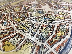
Beschreibung und Confrafactur der vornembster Stät der Welt. [title on spine: Nederlandse steden].
Anbieter: Antiquariaat A. Kok & Zn. B.V., Amsterdam, Niederlande
Bewertung:
Köln, 1574 [Reprint Amsterdam, Becht, 1972]. [151] pp. 37 col. double-page plts with plans (bird's-eye views). Brown imit. leather, lettered gilt to spine, gilt vignette to upper board. Sm. folio.Facsimile with a selection of all the plans of Dutch towns, published in the Braun & Hogenberg's Civitates Orbis Terrarum. - The plans in this reprint are reproduced from the German text edition published by H.von Ach (Cologne, 1574-1618).
-
Beschreibung der vornehmsten Städte der Welt. Tafelband.
Anbieter: SKULIMA Wiss. Versandbuchhandlung, Westhofen, Deutschland
Bewertung:
Nur Tafelband, ohne Kommentarband! Hrsg. von Anja Grebe und G. Ulrich Großmann. Die Städtebilder von Georg Braun und Frans Hogenberg zählen unbestritten zu den bedeutendsten Druckgraphiken der Frühen Neuzeit. Nahezu jede bekanntere deutsche Stadt ist mit einer Ansicht vertreten. Hinzu kommen Städte aus dem europäischen Ausland, aus Afrika und Vorderasien. Der ?Braun-Hogenberg? erschien zwischen 1572 und 1640 in sechs Originalausgaben. Dabei handelt es sich um sechs Bände im Folioformat, die rund 600 Stadtansichten auf 363 Doppeltafeln enthalten. Jeder Abbildung geht eine Erläuterung zu Geschichte und Bedeutung der Stadt voraus. Diese hochwertige Neuausgabe stellt ein Faksimile sämtlicher Bildtafeln dar. Beibehalten wurde die originale Anordnung aller Bände, ebenso die Unterbrechung der Bände durch die Titelseite. 408 Farbtafeln, Großformat 26,5 x 37,5 cm, Leinen (Lambert Schneider Verlag 2017) leichte Lagerspuren, Exemplar Nr. 865 der auf 999 Expl. limitierten und nummerierten Ausgabe 3127 g. Sprache: de.
-
![Bild des Verkäufers für Dovay; [Duacum, town of the Catuaci, most beautifully embellished by its appearance, its inhabitants and a university] zum Verkauf von Argosy Book Store, ABAA, ILAB](https://pictures.abebooks.com/inventory/md/md1248043266.jpg)
Dovay; [Duacum, town of the Catuaci, most beautifully embellished by its appearance, its inhabitants and a university]
Verlag: Braun & Hogenberg, Cologne, 1575
Anbieter: Argosy Book Store, ABAA, ILAB, New York, NY, USA
Bewertung:
unbound. Zustand: very good. View. Uncolored engraving. Image measures 13" x 15.75". Beautiful town plan of the fortified town of Douai in N. France. Douai, situated on the border of Flanders, Hainaut and Artois. From the city atlas "Civitates Orbis Terrarum", a collection of city views and plans created as a companion to Ortelius' "Theatrum Orbis Terrarum". The editions were published between 1572-1617. This edition has Latin text on verso. A few small tears and chipping to edges. Expert repairs to centerfold. Georg Braun (1541-1622) was a Catholic cleric who edited the "Civitates orbis terrarum," a collection of 546 prospects, bird's-eye views and maps of international cities. Hogenberg created the tables for the first 4 volumes. Together, these two geographers created a work that set new standard for cartography for the next century. This plan of Douai demonstrates the high quality of their work.
-
Zustand: -. Gefaltete Kupferstich-Karte. Blattmaß: 57 x 43 cm. Mit lateinischem Erklärungs-Text recto. Fotos gerne auf Anfrage.
-
Zustand: -. Originale Kupferstich-Ansicht der Stadt Landshut aus Braun und Hogenbergs "Civitates Orbis Terrarum" um 1580. Die Ansicht zeigt das Gebiet bzw. den Ort von Westen mit Isar und Burg Trausnitz. Plattenbereich: 33 cm x 42 cm. Kartograph: Frans Hogenberg (1535 - 1590) bei Georg Braun (1541 - 1622). Technik: Kupferstich. Guter Zustand. Leicht gebräunt. Im mittigen Knick hinterlegt.
-
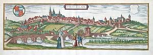
Fritzlar
Verlag: Braun, Köln, 1581
Karte
Kein Einband. Zustand: Gut bis sehr gut. Fritzlar. "Fritzlar". Altkol. Kupferstich aus G. Braun - F. Hogenberg, Civitates Orbis Terrarum, 1581. Mit ornament. Titelkart., 2 Wappen und Figuren vorne. 16:48,5 cm. Koeman IV, map 1255. - Gesamtansicht von Fritzlar. - Oben angerändert.
-
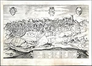
Tricaricum Basilicatae Civitas
Verlag: Hierat, Anton, Cologne, 1618
Tricarico. "Tricaricum Basilicatae Civitas". Orig. copperplate engraving from the 6th part of Latin ed. of Braun and Hogenberg's "Civitates Orbis Terrarum". Published by A. Hierat in Cologne, 1618. With engraved title, 3 coats-of-arms and ornamental cartouche with explanatory notes (1.-38.). 32:50,5 cm (12 3/4 x 20 inch.). Koeman IV, map 4477, ed. 41:1 (1617/18 B&H 6). - A birds-eye-view of Tricarico, a town in the province of Matera, Basilicata, southern Italy. - This view comes from the sixth and last volume of Civitates Orbis Terrarum ("Theatri Praecipuarum Totius Mundi Urbivm Liber Sextus"), published in a much smaller edition than previous volumes, and it is therefore rarer than most of Braun & Hogenberg city views. - Margins expertly restored.
-
Budingen
Verlag: Hierat, Anton, Cologne, 1617
Büdingen. "Budingen". Orig. copperplate engraving from the 6th part of Latin ed. of Braun and Hogenberg's "Civitates Orbis Terrarum". Published by A. Hierat in Cologne, 1618. With ornamental title-cartouche, another cartouche with quotation and the date of engraving (1617), 2 coats-of-arms (on blank) and several figures in the foreground. 30,5:50 cm (12 x 19 3/4 inch.). Koeman IV, map 700, ed. 41:1-3 (1617/18 B&H 6). - A view of Büdingen in Hessen.
-
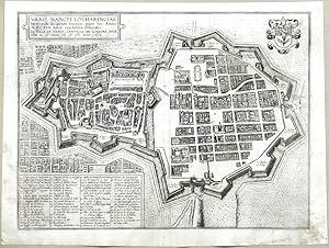
Urbis Nancei Lotharingiae Metropolis
Verlag: Hierat, Anton, Cologne, 1617
Nancy. "Urbis Nancei Lotharingiae Metropolis secundum formam quam hoc Anno M.DC.XVII. habet exactissima delineatio. La Ville de Nancy. Capitalle de Lorraine pour traicte au vif comme elle est ceste annee 1617". Orig. copperplate engraving from the 6th part of Latin ed. of Braun and Hogenberg's "Civitates Orbis Terrarum". Published by A. Hierat in Cologne, 1618. With title-cartouche, a cartouche with explanatory notes (1.-53.) and a coat-of-arms. 35:46 cm (13 3/4 x 18 1/4 inch.). Koeman IV, map 2968, ed. 41:1-3 (1617/18 B&H 6). - A birds-eye-view of Nancy. - Nice, dark impression .
-
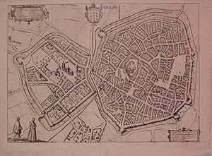
Arras
Verlag: Braun & Hogenberg, Cologne, 1572
Anbieter: Argosy Book Store, ABAA, ILAB, New York, NY, USA
Bewertung:
unbound. Zustand: very good. View. Uncolored engraving. Image measures 12.75" x 18.5". Town plan of Arras in N. France, including the coat of arms. Text on verso describes the town. From the city atlas "Civitates Orbis Terrarum", a collection of city views and plans created as a companion to Ortelius' "Theatrum Orbis Terrarum". The editions were published between 1572-1617. This edition has Latin text on back and is from Volume I. A few small tears to left and right edges. Expert repairs to centerfold. Minor creasing at top edge. Georg Braun (1541-1622) was a Catholic cleric who edited the "Civitates orbis terrarum," a collection of 546 prospects, bird's-eye views and maps of international cities. Hogenberg created the tables for the first 4 volumes. Together, these two geographers created a work that set new standard for cartography for the next century. This plan of Arras demonstrates the high quality of their work.
-
Campidonia vulgo Kemptten, peruetus sacri Romani Imperii oppid; C. 1590 map of Kempten, Swabia, Germany by Braun and Hogenberg
Verlag: Frans Hogenberg, 1599
Anbieter: Argosy Book Store, ABAA, ILAB, New York, NY, USA
Bewertung:
View. Color engraving. Image measures 17.5" x 13.25". This beautiful bird's eye view of Kempten was published by Braun and Hogenberg between 1572 and 1617. The title translates to Campidonia commonly known as Kempten, a famous city of the Holy Roman Empire in Southern Germany).The map depicts the walled city and surrounding fields in incredible detail with buildings drawn in profile. The key identifies 27 important sites of the time. The foreground features a couple dressed in the style of the city and the top includes three coat of arms. Kempten is now the largest town in Swabia, which is a cultural, historic and linguistic region in southwestern Germany. The view was published by Braun and Hogenberg in their famous city atlas "Civitates Orbis Terraru," a collection of city views and plans created as a companion to Ortelius' "Theatrum Orbis Terrarum" and published between 1572 and 1617. The view is in good condition with minor wear along the centerfold and minimal spotting. Georg Braun (1541-1622) was a Catholic cleric who edited the "Civitates orbis terrarum," a collection of 546 prospects, bird's-eye views and maps of international cities. Hogenberg created the tables for the first 4 volumes. Together, these two geographers created a work that set new standard for cartography for the next century. This colored view is a must have for collectors of the region.
-
Dillenburg - Segen
Verlag: Hierat, Anton, Cologne, 1617
Dillenburg - Siegen. "Dillenburgum Nassoviae comitum arx et natale solum. Segena Famosum comitat. Nassoviae Opp.". Orig. copperplate engraving from the 6th part of Latin ed. of Braun and Hogenberg's "Civitates Orbis Terrarum". Published by A. Hierat in Cologne, 1618. Two panoramic views printed from one desk. With two engraved titles ("Dillenburg" and "Segen"), two ornamental title-cartouches and two figures. 34:48,5 cm (13 1/2 x 19 inch.). Koeman IV, map 1077, ed. 41:1-3 (1617/18 B&H 6). - Paper fold before printing visible right of the centre.
-
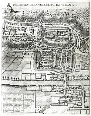
Description de la Ville de Bar
Verlag: Hierat, Anton, Cologne, 1617
Bar-le-Duc. "Description de la Ville de Bar faicte l'An 1617". Orig. copperplate engraving from the 6th part of Latin ed. of Braun and Hogenberg's "Civitates Orbis Terrarum". Published by A. Hierat in Cologne, 1618. With engraved title above the map, ornamental title-cartouche with explanatory notes (A.-Z.; 1.-18.) and a coat-of-arms. 44:35 cm (17 1/4 x 13 3/4 inch.). Koeman IV, map 388, ed. 41:1-3 (1617/18 B&H 6). - A birds-eye-view of Bar-le-Duc. - Nice, dark impression .
-

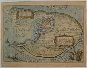
Sluys.
Erscheinungsdatum: 1581
Anbieter: Altea Antique Maps, London, Vereinigtes Königreich
Verbandsmitglied: ABA ILAB PBFA
Bewertung:
Karte
Cologne, 1581-, Latin text edition. Original colour. 290 x 405mm. Sluis in Belgium, from Braun & Hogenberg's 'Civitates Orbis Terrarum', the first series of printed townplans.
-
Wesel. Wesalia Inferior. [1572]. [Kolorierter Original-Kupferstich, gerahmt / Colored original- copper engraving, framed].
Kunst / Grafik / Poster Erstausgabe
Frans Hogenberg (oder Hooghenbergh, auch Franz Hogenberggeboren 1535 in Mechelen, gestorben 1590 in Köln. Kupferstecher und Radierer. Georg Braun, geboren 1541 in Köln, gestorben 1622 ebenda. Theologe, Kanoniker. Braun und Hogenberg waren in den Jahren von 1572 bis 1618 Herausgeber des Städteansichtenbuches 'Civitates Orbis Terrarum'. Kolorierter Original Kupferstich. Gesamtansicht von Wesel aus Braun-Hogenbergs Städte-Atlas 'Civitatis Orbis Terrarum' von 1572. Vedute der Stadt Wesel mit zahlreichen Gebäuden, Wehranlagen und dem angrenzenden Flusslauf des Rheins. Blatt mit Bugfalte. Professionell gerahmt hinter Glas/Passepartout im teils vergoldeten Holzrahmen. Nicht ausgerahmt. Maße Abbildung: 12,2 x 47,0 cm. Maße Rahmen: 31,0 x 68,0 cm. Rahmen mit geringen Gebrauchsspuren, Kupferstich minimal fleckig. Sehr gutes Exemplar. Colored original engraving. General view of Wesel from Braun-Hogenberg's city atlas 'Civitatis Orbis Terrarum' from 1572. View of the city of Wesel with numerous buildings, weir systems and the adjacent course of the Rhine. Sheet with centrefold. Professionally framed behind glass/passe-partout in a partially gilded wooden frame. Not examined out of frame. Dimensions illustration: 12.2 x 47.0 cm. Frame dimensions: 31.0 x 68.0 cm. Frame with minor signs of wear, copper engraving minimally stained. Very good copy.
-

Famagusta.
Erscheinungsdatum: 1600
Anbieter: Altea Antique Maps, London, Vereinigtes Königreich
Verbandsmitglied: ABA ILAB PBFA
Bewertung:
Karte
Cologne, c.1600. Original colour. 160 x 230mm. Trimmed from a larger sheet, false margins at top & left. An early 'map-view', with the major buildings shown in profile with little consideration for perspective.
-
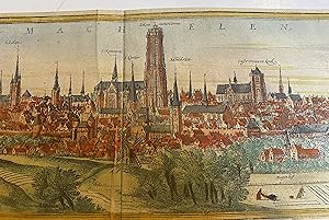
Nitidissimae civitatis mechlineensis, in meditvillio Brabantiae sitae, exactis delineatio. Panoramic view of Mechelen
Verlag: Köln G. von Kempen 1572, 1572
Anbieter: Harrison-Hiett Rare Books, Richelieu, Frankreich
Verbandsmitglied: ABA ILAB NVVA
Bewertung:

Karte
Attractive panoramic city view (copper engraving) of the city of Mechelen (Machelen) removed from "Civitates Orbis Terrarum" Volume One. Nice contemporary hand colouring. Image area is 11.7cm x 47.5cm. Sheet is 14cm x 55cm. Two sheets attached to verso. To the rear of one sheet is half a page of text. Slightly dusty but very presentable copy, with bright colouring. Shows the tower and other significant landmarks. Countryside around and figures standing to the foreground.
-
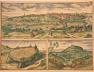
Pictavia Vulgo Poictiers; La pierre levee demie lieue de Poictiers; Prospectus Montis Henrici vulgo Montherri
Erscheinungsdatum: 1596
Anbieter: Argosy Book Store, ABAA, ILAB, New York, NY, USA
Bewertung:
View. Color engraving. Image measures 13" x 15.75". Panorama of the city of Poitiers (in W. Central France), presented from the east. Image lower left is a dolmen, also known as a portal tomb. (Early graffiti reference with carved names). The third view shows Montargis. Treated as a companion to Ortelius' "Theatrum Orbis Terrarum". The editions were published between 1572-1617. This edition has Latin text on back and is from Volume I. Margins cropped and some toning and stains but otherwise in good condition. Georg Braun (1541-1622) was a Catholic cleric who edited the "Civitates orbis terrarum," a collection of 546 prospects, bird's-eye views and maps of international cities. Hogenberg created the tables for the first 4 volumes. Together, these two geographers created a work that set new standard for cartography for the next century. This engraving demonstrates the high quality of their work.
-
Francenbergum, vel ut alij Francoburgum Hassiae Opp.; C. 1590 map of Frankenberg, Hesse, Germany by Braun and Hogenberg
Verlag: Frans Hogenberg, 1599
Anbieter: Argosy Book Store, ABAA, ILAB, New York, NY, USA
Bewertung:
View. Color engraving. Image measures 19.25" x 12". This fine decorative bird's eye view depicts the town of Frankenberg, a town in Hesse, central Germany. Published between 1572 and 1617 by Braun and Hogenberg, the map depicts the town from the northeast, on a hill above the River Eder. The walled city is beautifully depicted surrounded by fields, separated by fences. The Liebfrauenkirche, the three-aisled Church built in the gothic style in 1286, and based on the model of the Elizabeth Church in Marburg, is seen towering above the town. The foreground features three figures, dressed in the style of the time. Three crests are featured above the title, including one that depicts a castle with a tower, together with the letter F. The view was published by Braun and Hogenberg in their famous city atlas "Civitates Orbis Terraru," a collection of city views and plans created as a companion to Ortelius' "Theatrum Orbis Terrarum" and published between 1572 and 1617. The view is in good condition with minor wear along the centerfold and minimal spotting. Georg Braun (1541-1622) was a Catholic cleric who edited the "Civitates orbis terrarum," a collection of 546 prospects, bird's-eye views and maps of international cities. Hogenberg created the tables for the first 4 volumes. Together, these two geographers created a work that set new standard for cartography for the next century. This colored view is a must have for collectors of the region.
-
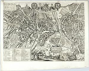
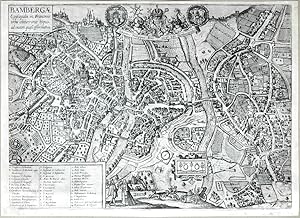
Bambergae
Verlag: Hierat, Anton, Cologne, 1617
Bamberg. "Bambergae Episcopalis in Franconiae typus, ad vivum quasi efformatus". Orig. copperplate engraving from the 6th part of Latin ed. of Braun and Hogenberg's "Civitates Orbis Terrarum". Published by A. Hierat in Cologne, 1618. A birds-eye-view of Bamberg. With title-cartouche, a cartouche with dedication to the prince-bishop Johann Philipp von Gebsattel with 3 great coats-of-arms, ornamental cartouche with "Glycyrriza", a cartouche with explanatory notes (A.-Z.; a.-b.; 1.-14.) and with several figures in the foreground. 37:51 cm (14 3/4 x 20 inch.). Koeman IV, map 356, ed. 41:1-3 (1617/18 B&H 6). - A birds-eye-view of Bamberg. - Nice, dark impression . - Left margin cutted (in lower part ca. 1-2 mm to the desk) and professionally restored.
-
Die Fürstliche Hauptt Statt Konigsbergk in Preussen. [1581]. [Original-Kupferstich, gerahmt / original- copper engraving, framed].
Kunst / Grafik / Poster Erstausgabe
Frans Hogenberg (oder Hooghenbergh, auch Franz Hogenberggeboren 1535 in Mechelen, gestorben 1590 in Köln. Kupferstecher und Radierer. Georg Braun, geboren 1541 in Köln, gestorben 1622 ebenda. Theologe, Kanoniker. Braun und Hogenberg waren in den Jahren von 1572 bis 1618 Herausgeber des Städteansichtenbuches 'Civitates Orbis Terrarum'. Erste gedruckte Gesamtansicht von Kaliningrad (Königsberg) aus Braun-Hogenbergs Städte-Atlas 'Civitatis Orbis Terrarum' von 1581. Mit Text-Kartusche: "Mons Regivs; Prvssiae, sive Borvssiae, vrbs Maritima, elegantissima Principis sedes". Repertorium älterer Topographie, Fauser 6726. Professionell gerahmt hinter Glas/Passepartout im teils vergoldeten Holzrahmen. Nicht ausgerahmt. Maße Abbildung: 19,5 x 41,5 cm. Maße Rahmen: 35,0 x 64,0 cm. Sehr gutes Exemplar. First printed overall view of Kaliningrad (Königsberg) from Braun-Hogenberg's city atlas 'Civitatis Orbis Terrarum' from 1581. With text cartouche: "Mons Regivs; Prvssiae, sive Borvssiae, vrbs Maritima, elegantissima Principis sedes". Repertory of older topographies, Fauser 6726. Professionally framed behind glass/passe-partout in a partly gilded wooden frame. Not examined out of frame. Dimensions illustration: 19.5 x 41.5 cm. Frame dimensions: 35.0 x 64.0 cm. Very good copy.
-
Nitidissimae civitatis mechlineensis, in meditvillio Brabantiae sitae, exactis delineatio. Large map of Mechelen
Verlag: Köln G. von Kempen 1572, 1572
Anbieter: Harrison-Hiett Rare Books, Richelieu, Frankreich
Verbandsmitglied: ABA ILAB NVVA
Bewertung:
Karte
Single sheet. Attractive overhead city view / map (copper engraving) of the city of Mechelen (Machelen) removed from "Civitates Orbis Terrarum" Volume One. With the Royal coat of arms and the arms of Mechelen, as well as a title cartouche. Nice contemporary hand colouring. Image area is 33.5cm x 46cm. Sheet is 40cm x 54cm. Two sheets attached to verso. To the rear of one sheet is a page of text (with a historiated initial) about Mechelen. This is somewhat darkened and foxed. Slightly dusty but very presentable copy, with bright colouring. Shows the tower and other significant landmarks. Countryside around and figures standing to the foreground.
-
Brilium, Holandiae Opp. Ob Intestinum Batavicum Bellum, Quod Anno Partae Salutis, M.D.LXXII. Calend Aprlis, Hic Initium Sumpsit, Famosum
Verlag: Braun & Hogenberg, Cologne, 1575
Anbieter: Argosy Book Store, ABAA, ILAB, New York, NY, USA
Bewertung:
unbound. Zustand: very good(-). View. Engraving with hand coloring. Image measures 13.75" x 19.25". Beautiful town plan of Brielle (den Briel) in the Netherlands, circa 1575. Den Briel is a town, municipality and historic seaport in the western Netherlands, in the province of South Holland. The panoramic birds-eye view reveals the pastoral and maritime nature of the area. North is oriented at the bottom of the page. From the city atlas "Civitates Orbis Terrarum", a collection of city views and plans created as a companion to Ortelius' "Theatrum Orbis Terrarum". The editions were published between 1572-1617. This edition has Latin text on back and is from Volume II. Overall toning and some mat burn. Minor wear along edges. Small holes along centerfold. Georg Braun (1541-1622) was a Catholic cleric who edited the "Civitates orbis terrarum," a collection of 546 prospects, bird's-eye views and maps of international cities. Hogenberg created the tables for the first 4 volumes. Together, these two geographers created a work that set new standard for cartography for the next century. This plan of Brielle demonstrates the high quality of their work.
-
Bambergae
Verlag: Grigorio Leti, Amsterdam, 1689
Karte
Kein Einband. Zustand: Sehr gut. Bamberg. "Bambergae Episcopalis in Franconiae typus, ad vivum quasi efformatus". Orig. copperplate engraving, Braun & Hogenberg, 1617/18 from G. Leti, 'Ritratti Historici', Amsterdam, 1689. With title-cartouche, a cartouche with dedication to the prince-bishop Johann Philipp von Gebsattel with 3 great coats-of-arms, ornamental cartouche with Glycyrrhiza ("Glycyrriza"), a cartouche with explanatory notes and with several figures in the foreground. 37:51 cm (14 3/4 x 20 inch.). Koeman IV, map 356 - this edition is not listed. - A birds-eye-view of Bamberg. - Nice, dark impression.
-
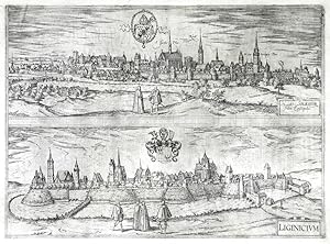
Nissa Silesior . - Liginicium
Verlag: Hierat, Anton, Cologne, 1617
Nysa - Legnica. "Nissa Silesior sedes Episcopalis - Liginicium". Orig. copperplate engraving from the 6th part of Latin ed. of Braun and Hogenberg's "Civitates Orbis Terrarum". Published by A. Hierat in Cologne, 1618. Two panoramic views printed from one desk. With two ornamental title-cartouches, 2 coats-of-arms and figures. 33:45 cm (13 x 17 3/4 inch.). Koeman IV, map 3140, ed. 41:1-3 (1617/18 B&H 6). - Two views of cities in southwest Poland. - A crack in the lower right margin (just reaching into the picture) professionally restored - see picture.
-
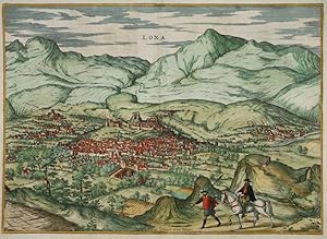
Loxa.
Erscheinungsdatum: 1575
Anbieter: Altea Antique Maps, London, Vereinigtes Königreich
Verbandsmitglied: ABA ILAB PBFA
Bewertung:
Karte
Cologne, 1575-, Latin text edition. Coloured. 355 x 495mm. Loja, a town west of Granada, after Joris Hofnagle, published in Braun & Hogenberg's 'Civitates Orbis Terrarum', the first series of printed townplans. Hoefnagel (1542-1601) was an painter and engraver born in Antwerp who travelled extensively in Europe, including Spain (1563-7, in the company of Abraham Ortelius) and England (1569-71). In this plate he has included a portrait of himself on foot and Ortelius riding a horse.
-
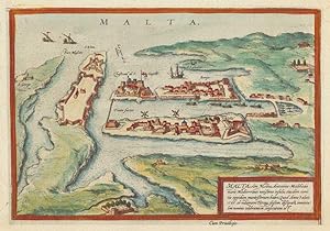
Malta.
Erscheinungsdatum: 1600
Anbieter: Altea Antique Maps, London, Vereinigtes Königreich
Verbandsmitglied: ABA ILAB PBFA
Bewertung:
Karte
Cologne, c.1600. Original colour. 160 x 230mm. Trimmed into plate left and bottom, new margins added. An early 'map-view' of Valletta, with the major buildings shown in profile with little consideration for perspective.
-
Calaris.
Verlag: Cologne, 1592
Anbieter: Alexandre Antique Prints, Maps & Books, Toronto, ON, Kanada
Bewertung:

Karte
Size : 160x232 (mm), 6.25x9.125 (Inches), Original Hand Coloring Very good, right and lower margins extended.
-
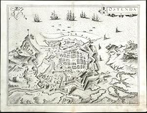
Ostenda
Verlag: Hierat, Anton, Cologne, 1618
Ostende. "Ostenda". Orig. copperplate engraving from the 6th part of Latin ed. of Braun and Hogenberg's "Civitates Orbis Terrarum". Published by A. Hierat in Cologne, 1618. With decorative title-cartouche, a coat-of-arms, and several ships. 35:46 cm (13 3/4 x 18 1/4 inch.). Koeman IV, map 3167, ed. 41:1 (1617/18 B&H 6). - A birds-eye-view of Ostend (German: Ostende, Dutch: Oostende), a Belgian coastal city, located in the province of West Flanders. - This view comes from the sixth and last volume of Civitates Orbis Terrarum ("Theatri Praecipuarum Totius Mundi Urbivm Liber Sextus"), published in a much smaller edition than previous volumes, and it is therefore rarer than most of Braun & Hogenberg city views.
![Bild des Verkäufers für [London] Londinum Feracissimi Angliae Regni Metropolis 1572 Vintage 1960's reproduction map zum Verkauf von PROCTOR / THE ANTIQUE MAP & BOOKSHOP](https://pictures.abebooks.com/inventory/md/md31523271076.jpg)


![Bild des Verkäufers für Wesel. Wesalia Inferior. [1572]. [Kolorierter Original-Kupferstich, gerahmt / Colored original- copper engraving, framed]. zum Verkauf von Antiquariat Lenzen](https://pictures.abebooks.com/inventory/md/md31395053925.jpg)
![Bild des Verkäufers für Die Fürstliche Hauptt Statt Konigsbergk in Preussen. [1581]. [Original-Kupferstich, gerahmt / original- copper engraving, framed]. zum Verkauf von Antiquariat Lenzen](https://pictures.abebooks.com/inventory/md/md31395041667.jpg)