Gesamtpreis (1 Artikel Artikel):
Versandziel:

bowen eman (43 Ergebnisse)
Direkt zu den wichtigsten Suchergebnissen
Suchfilter
Produktart
- Alle Product Types
- Bücher (10)
- Magazine & Zeitschriften (Keine weiteren Ergebnisse entsprechen dieser Verfeinerung)
- Comics (Keine weiteren Ergebnisse entsprechen dieser Verfeinerung)
- Noten (Keine weiteren Ergebnisse entsprechen dieser Verfeinerung)
- Kunst, Grafik & Poster (Keine weiteren Ergebnisse entsprechen dieser Verfeinerung)
- Fotografien (Keine weiteren Ergebnisse entsprechen dieser Verfeinerung)
- Karten (32)
- Manuskripte & Papierantiquitäten (1)
Zustand Mehr dazu
- Neu (Keine weiteren Ergebnisse entsprechen dieser Verfeinerung)
- Wie Neu, Sehr Gut oder Gut Bis Sehr Gut (1)
- Gut oder Befriedigend (15)
- Ausreichend oder Schlecht (Keine weiteren Ergebnisse entsprechen dieser Verfeinerung)
- Wie beschrieben (27)
Einband
- alle Einbände
- Hardcover (3)
- Softcover (Keine weiteren Ergebnisse entsprechen dieser Verfeinerung)
Weitere Eigenschaften
- Erstausgabe (1)
- Signiert (Keine weiteren Ergebnisse entsprechen dieser Verfeinerung)
- Schutzumschlag (Keine weiteren Ergebnisse entsprechen dieser Verfeinerung)
- Angebotsfoto (36)
Sprache (3)
Gratisversand
- Kostenloser Versand nach USA (Keine weiteren Ergebnisse entsprechen dieser Verfeinerung)
Land des Verkäufers
Verkäuferbewertung
-

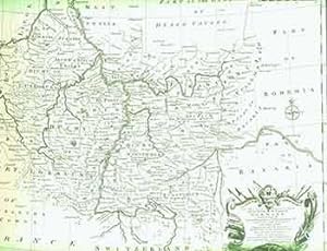
A new & correct map of the Netherlands or low countries.
Verlag: For Mr Tindal 's continuation of Mr Rapin's history of England o J (um ), 1750
Anbieter: Ottmar Müller, Offenburg, Deutschland
Verkäuferbewertung 2 von 5 Sternen

Größe ca. 50 x 40 cm. -Gefaltet, gebräunt, Randeinrisse. 1000 gr.
-
1720 BRITANNIA DEPICTA or Ogilby improv'd; : being a correct coppy of Mr: Ogilby's Actual survey of all ye direct & principal cross roads in England and Wales:
Sprache: Englisch
Verlag: Published by Printed for, & sold by Tho: Bowles print & map seller, London, London, 1720
Anbieter: Andrew Cox PBFA, Shropshire, Vereinigtes Königreich
Verbandsmitglied: PBFA
Verkäuferbewertung 5 von 5 Sternen

Erstausgabe
EUR 2.314,75
EUR 22,47 Versand
Versand von Vereinigtes Königreich nach USAAnzahl: 1 verfügbar
In den WarenkorbFull-Leather. Zustand: Good. 1st Edition. BRITANNIA DEPICTA or Ogilby improv'd; : being a correct coppy of Mr: Ogilby's Actual survey of all ye direct & principal cross roads in England and Wales: wherein are exactly delineated & engraven, all ye cities, towns, villages, churches, seats &c. scituate on or near the roads, with their respective distances in measured and computed miles. And to render this - work universally usefull & agreeable, (beyond any of it's [sic] kind) are added in a clear & most compendious method 1, a full & particular description & account of all the cities, borough-towns, towns-corporate &c. their arms, antiquity, charters, privileges, trade, rarities, &c. with suitable remarks on all places of note drawn from the best historians and antiquaries - By Ino. Owen of the Midd: Temple gent. 2, The arms of the peers of this realm who derive their titles from places lying on, or near the roads 3, The arms of all ye bishopricks & deanaries, their foundation, extent, yearly-value, number of parishes &c. 4, The arms, & a succinct account of both universities & their respective colleges, their foundations fellowships &c. Lastly particular & correct maps - of all ye counties of South Britain; with a - summary description of each county, it's [sic] circumference, number of acres, boro' & market towns & parishes, air, soil, com[m]odities, manufactures & what each pays in ye 2. sh Aid &c. The whole for its compendious variety & exactness, preferable to all other books of roads hitherto published or proposed; and calculated not only for the direction of the traveller (as they are) but the general use of the gentleman and tradesman by Eman: Bowen engraver. First Edition 1720 Published in London in 1720 this is the First Edition, later issue of Britannia Depicta by Emanuel Bowen, which was based on the earlier work of John Ogilby who published the First British road Atlas in 1675 bound in a old full calf leather binding, 8 inches tall approx. a beautifully produced book of engraved county maps and strip road maps, for the traveller or coach driver. 273 pages, some cracking to leather joints though both boards firmly attached, scuffing and edge wear else binding is in good general condition, internally endpapers browned with old ownership inscription and a few small holes, the title page has been neatly strengthened with paper to leading edge, some light browning, and minor marks to a few page edges else contents in nice general condition, A GENERALLY VERY GOOD EXAMPLE OF A LATER ISSUE OF THE FIRST EDITION.
-
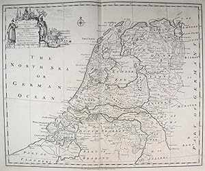
A New and Correct Map of the Seven United Provinces.
Verlag: London-47, 1743
Anbieter: Robert Frew Ltd. ABA ILAB, London, Vereinigtes Königreich
Verbandsmitglied: ABA ILAB PBFA
Verkäuferbewertung 5 von 5 Sternen
Karte
EUR 59,35
EUR 11,52 Versand
Versand von Vereinigtes Königreich nach USAAnzahl: 1 verfügbar
In den Warenkorb41 x 48 cm. Uncoloured. Double page map of the Netherlands. Tear without loss at foot of centre fold affecting 2cm of plate. Edges lightly toned. Generally good.
-
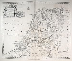
A New and Correct Map of the Seven United Provinces.
Verlag: Londonc., 1750
Anbieter: Robert Frew Ltd. ABA ILAB, London, Vereinigtes Königreich
Verbandsmitglied: ABA ILAB PBFA
Verkäuferbewertung 5 von 5 Sternen
Karte
EUR 59,35
EUR 11,52 Versand
Versand von Vereinigtes Königreich nach USAAnzahl: 1 verfügbar
In den Warenkorb34.5 x 42.3 cm. Uncoloured. Copper engraved map of The Netherlands. Title cartouche to upper left corner featuring an illustration of shipbuilding and other nautical references. Two vertical folds. Some light offsetting, otherwise in very good condition.
-

Britannia Depicta or Ogilby Improv'd - being a correct coppy [sic] of Mr Ogilby's actual survey of all the direct and principal cross-roads in England and Wales.
Verlag: London, 1720, printed by Tho. Bowles, 1720
Anbieter: Grant's Bookshop, Cheltenham, VIC, Australien
Verkäuferbewertung 4 von 5 Sternen

Octavo, vi+274 pages, map illustrated, original full leather, sympathetically re-backed, title page repaired with backing paper (some loss to lower front foredge with only a few words of text lost), light soiling to endpapers, 300 year old paper is looking its age, but overall a very good sound copy of an early road atlas of England and Wales.
-
A New & ACCURATE MAP OF SPAIN and PORTUGAL. Drawn from Surveys assisted by ye. most approved Modern Maps and Charts. The whole being Regulated by Astronomical Observations. By Eman. Bowen - Original Antique Map, Printed Circa 1766
Sprache: Englisch
Erscheinungsdatum: 1766
Anbieter: K Books Ltd ABA ILAB, York, YORKS, Vereinigtes Königreich
Verbandsmitglied: ABA ILAB PBFA
Verkäuferbewertung 5 von 5 Sternen
EUR 118,70
EUR 22,47 Versand
Versand von Vereinigtes Königreich nach USAAnzahl: 1 verfügbar
In den WarenkorbNo Binding. Zustand: Very Good. Bowen, Emanuel (illustrator). Portugal - an Antique Map A New & ACCURATE MAP OF SPAIN and PORTUGAL. Drawn from Surveys assisted by ye. most approved Modern Maps and Charts. The whole being Regulated by Astronomical Observations. By Eman. Bowen - Original Antique Map, Printed Circa 1766 Original antique hand-coloured map, colouring not contemporary, but delicately and expertly done. Mounted (matted) and ready to frame. Figurative title cartouche in top right hand corner plus scale, with the legend "A New & ACCURATE MAP OF SPAIN and PORTUGAL. Drawn from Surveys assisted by ye. most approved Modern Maps and Charts. The whole being Regulated by Astronomical Observations. By Eman. Bowen", printed c1766. There are two inset maps of the Minorcan harbour of Port Mahon and a chart of the Straits of Gibraltar accompanied by some notes on the two, together with an explanation of how the details of the coasts of the maps were arrived at - most informative. Includes the Islands of Minorca, Majorca and the northern coast of Africa.
-

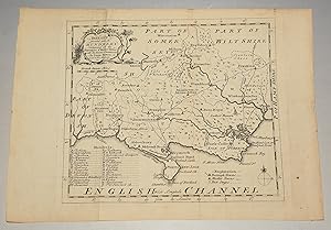
Original Antique Map of ?SURREY Divided into Hundreds? Containing the Borough and Market Towns &c. Roads & Distances.
Verlag: London, Printed for General Magazine of Arts and Sciences 1756, 1756
Anbieter: PROCTOR / THE ANTIQUE MAP & BOOKSHOP, DORCHESTER, Vereinigtes Königreich
Verbandsmitglied: PBFA
Verkäuferbewertung 5 von 5 Sternen
EUR 85,47
EUR 23,05 Versand
Versand von Vereinigtes Königreich nach USAAnzahl: 1 verfügbar
In den WarenkorbUnmounted. Size 20cm x 18cm In very good condition. With two neat center folds. A very clean, crisp map. Uncoloured --- Bowen map of SURREY showing Hundreds, towns villages, rivers and post roads. With descriptions of main towns and the County itself. This small series were issued in The Natural History of England which formed part of The General Magazine of Arts and Sciences published from 1755 to 1764.
-
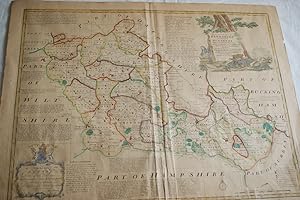
Buckinghamshire, divided into its hundreds containing the burough and market towns, with the forests hills rivers roads distances c,
Anbieter: Antiqua Print Gallery, London, Vereinigtes Königreich
Verkäuferbewertung 5 von 5 Sternen
EUR 62,91
EUR 11,52 Versand
Versand von Vereinigtes Königreich nach USAAnzahl: 1 verfügbar
In den Warenkorb -
ORIGINAL ENGRAVED LARGE MAP OF BUCKINGHAMSHIRE. An accurate map of Buckinghamshire divided into hundreds drawn from the best Authorities assisted by the most approved modern maps with various improvements. Illustrated with historical extracts relative to Natural History, produce, Trade & manufactures & the present State of the principal towns.
Verlag: Sayer Golden Buck Fleet Street Robert Wilkinson No date Ca 1780, 1780
Anbieter: PROCTOR / THE ANTIQUE MAP & BOOKSHOP, DORCHESTER, Vereinigtes Königreich
Verbandsmitglied: PBFA
Verkäuferbewertung 5 von 5 Sternen
EUR 117,52
EUR 23,05 Versand
Versand von Vereinigtes Königreich nach USAAnzahl: 1 verfügbar
In den WarenkorbEngraved surface: 70 cm x 54 cm. In cream frame & gilt lines glass front. Frame size: approx.80 cm x 62cm. Very good. Map a little tanned. Frame has a few small nicks lower edge. Nice hand-colouring. Attractive map.
-
(Original Engraved Map of.) Dorset, Divided into its Hundreds. Containing all the Market Towns, with Roads & Districts.
Verlag: Eman. Bowen, Geog. To His Majesty No date Ca 1758, 1758
Anbieter: PROCTOR / THE ANTIQUE MAP & BOOKSHOP, DORCHESTER, Vereinigtes Königreich
Verbandsmitglied: PBFA
Verkäuferbewertung 5 von 5 Sternen
Karte
EUR 117,52
EUR 23,05 Versand
Versand von Vereinigtes Königreich nach USAAnzahl: 1 verfügbar
In den WarenkorbOriginal engraved antique hand-coloured map. Size approx 8 x 7 inches In very good condition. Map tanned but printing is clear and crisp. With crease just slightly off-centre.
-
A New and Correct Map of the South West part of Germany, Containing the Archbishopricks and Electorates of Mentz and Triers. (18th Century Map of Germany).
Verlag: [London]: 18th Century European Publisher, [1700s]., 1700
Anbieter: Wittenborn Art Books, San Francisco, CA, USA
Verkäuferbewertung 5 von 5 Sternen
Manuskript / Papierantiquität
Zustand: Good. 20 x 16 inches. Very Good. Minor loss from pinholes in top right corner. Fine copperplate engraving. 18th Century, uncolored, folded map of Germany. Scarce.
-
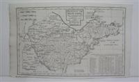
AN ACCURATE MAP OF BERKSHIRE DIVIDED INTO ITS HUNDREDS 1756
Verlag: Carington Bonles in St Paul Chuch Yard, London, 1756
Anbieter: Librairie RAIMOND, Dourges, Frankreich
Verkäuferbewertung 5 von 5 Sternen
Karte
Pas de couverture. Zustand: Assez bon. CARTE ANCIENNE AN ACCURATE MAP OF BERKSHIRE DIVIDED INTO ITS HUNDREDS 1756 Drawn from the best authorities asisted by Surveys and most approved maps with vriuous improvements illustrated with historical extracts relative to trade, manufactures, natural produce & present state of the principal town &c. by Eman BOWEN, geographer to his Majesty 1756, London, imprimé par Carington Bonles in St Paul Chuch Yard Carte ancienne illustrée et réhaussée de couleurs ŕ la main, légende en anglais (Gravure authentique du XVIIIe sičcle-original etching) Dimensions de la feuille : 76 x 58,5 cm environ Dimensions de la carte au coup de planche : 68,5 x 53 cm environ Etat : une coupure sans manque en bordure inférieure droite, deux accrocs, beau documents.
-
A Plan of the Harbour Town and Forts of Porto Bello, when taken by Admiran Vernon on Novr. 22.d 1739 with 6 ships only
Verlag: London, 1747
Anbieter: Alexandre Antique Prints, Maps & Books, Toronto, ON, Kanada
Verkäuferbewertung 5 von 5 Sternen
Karte
Zustand: Very Good; margins extended. Size : 87x149 (mm), 3.375x5.875 (Inches), Hand Colored.
-
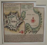
A Plan of the Dutch Fort at the Cape of Good Hope.
Verlag: London, 1752
Anbieter: Alexandre Antique Prints, Maps & Books, Toronto, ON, Kanada
Verkäuferbewertung 5 von 5 Sternen
Karte
Size : 117x123 (mm), 4.625x4.875 (Inches), Hand Colored Very Good; some age toning; old mounting on heavier paper for long term preservation.
-
A Plan of the Town and Harbour of Louisbourg in the Island of Cape Breton
Verlag: London, 1747
Anbieter: Alexandre Antique Prints, Maps & Books, Toronto, ON, Kanada
Verkäuferbewertung 5 von 5 Sternen
Karte
Zustand: Very Good; margins extended. Size : 137x151 (mm), 5.375x6 (Inches), Hand Colored.
-
The Havana
Verlag: London, 1747
Anbieter: Alexandre Antique Prints, Maps & Books, Toronto, ON, Kanada
Verkäuferbewertung 5 von 5 Sternen
Karte
Zustand: Very Good; margins extended. Size : 57x69 (mm), 2.25x2.75 (Inches), Hand Colored.
-
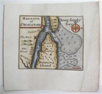
Harbour of St. Augustine
Verlag: London, 1752
Anbieter: Alexandre Antique Prints, Maps & Books, Toronto, ON, Kanada
Verkäuferbewertung 5 von 5 Sternen
Karte
Size : 59x71 (mm), 2.375x2.75 (Inches), Hand Colored Very Good; mounted on 18th century paper.
-

A New and Accurate Map of the Kingdom of Hungary and Principality of Transilvania with the Bordering Countries Drawn from the best authorities assisted by the most approved Modern Maps.
Verlag: London, 1747
Anbieter: Alexandre Antique Prints, Maps & Books, Toronto, ON, Kanada
Verkäuferbewertung 5 von 5 Sternen
Karte
Zustand: Very Good. Detailed map of Hungary and Translivania region. , Size : 354x434 (mm), 13.875x17.125 (Inches), Hand Colored.
-
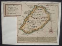
A Correct Map of the Island of St. Hellena, belonging to the English East Infia Company
Verlag: London, 1752
Anbieter: Alexandre Antique Prints, Maps & Books, Toronto, ON, Kanada
Verkäuferbewertung 5 von 5 Sternen
Size : 160x217 (mm), 6.25x8.5 (Inches), Hand Colored Very Good; some age toning; margins shaved; map mounted on heavier paper for long term preservation.
-
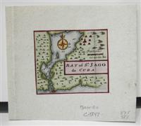
Bay of St. Jago de Cuba
Verlag: London, 1747
Anbieter: Alexandre Antique Prints, Maps & Books, Toronto, ON, Kanada
Verkäuferbewertung 5 von 5 Sternen
Karte
Size : 57x66 (mm), 2.25x2.625 (Inches), Hand Colored Excellent; mounted on heavier paper.
-
A Correct Map of the Island of St. Hellena, belonging to the English East Infia Company
Verlag: c. 1752, London., 1752
Anbieter: Alexandre Antique Prints, Maps & Books, Toronto, ON, Kanada
Verkäuferbewertung 5 von 5 Sternen
Karte
Zustand: Very Good. Very Good; map mounted on heavier paper for long term preservation, Size : 159x216 (mm), 6.25x8.50 (Inches), Hand Colored.
-

The First Sheet of Chinese Tartary, containing the Province of Lyau-tong and the parts about Kirin-ula, the Country of Karchin and other districts of the Mongols
Verlag: London, 1738
Anbieter: Alexandre Antique Prints, Maps & Books, Toronto, ON, Kanada
Verkäuferbewertung 5 von 5 Sternen
Karte
Size : 310x480 (mm), 12.25x18.875 (Inches), Black & White Very Good, mounted on acid-free paper for long term preservation.
-

Cities of the Province of Shen-Si
Verlag: London, 1738
Anbieter: Alexandre Antique Prints, Maps & Books, Toronto, ON, Kanada
Verkäuferbewertung 5 von 5 Sternen
Karte
Zustand: Very Good. Size : 380x235 (mm), 15x9.25 (Inches), Black & White.
-

Cities of the Province of Hu-Quang
Verlag: London, 1738
Anbieter: Alexandre Antique Prints, Maps & Books, Toronto, ON, Kanada
Verkäuferbewertung 5 von 5 Sternen
Karte
Zustand: Very Good. Size : 380x235 (mm), 15x9.25 (Inches), Black & White.
-

Province VII Ho-Nan.
Verlag: London, 1738
Anbieter: Alexandre Antique Prints, Maps & Books, Toronto, ON, Kanada
Verkäuferbewertung 5 von 5 Sternen
Karte
Zustand: excellent. Size : 335x325 (mm), 13.125x12.75 (Inches), Black & White.
-

Cites of the Province of Kyang-si, Fo-kyken, Shan-si & Yu-nan
Verlag: London, 1738
Anbieter: Alexandre Antique Prints, Maps & Books, Toronto, ON, Kanada
Verkäuferbewertung 5 von 5 Sternen
Karte
Zustand: Very Good. Size : 385x235 (mm), 15.125x9.25 (Inches), Black & White.
-

Cities of the Province of Che-Kyang
Verlag: London, 1738
Anbieter: Alexandre Antique Prints, Maps & Books, Toronto, ON, Kanada
Verkäuferbewertung 5 von 5 Sternen
Karte
Zustand: Very Good. Size : 390x240 (mm), 15.375x9.5 (Inches), Black & White.
-

Cities of the Province of Quey-Chew
Verlag: London, 1738
Anbieter: Alexandre Antique Prints, Maps & Books, Toronto, ON, Kanada
Verkäuferbewertung 5 von 5 Sternen
Karte
Zustand: Very Good. Size : 380x230 (mm), 15x9 (Inches), Black & White.
-

Cities of the Province of Pe-Che-Li
Verlag: London, 1738
Anbieter: Alexandre Antique Prints, Maps & Books, Toronto, ON, Kanada
Verkäuferbewertung 5 von 5 Sternen
Karte
Zustand: Very Good. Size : 380x235 (mm), 15x9.25 (Inches), Black & White.
-
Province VIII SHAN-TONG
Verlag: London, 1738
Anbieter: Alexandre Antique Prints, Maps & Books, Toronto, ON, Kanada
Verkäuferbewertung 5 von 5 Sternen
Karte
Zustand: Excellent. Size : 240x380 (mm), 9.5x15 (Inches), Black & White.