Gesamtpreis (1 Artikel Artikel):
Versandziel:

bien julius (27 Ergebnisse)
Direkt zu den wichtigsten Suchergebnissen
Suchfilter
Produktart
- Alle Product Types
- Bücher (23)
- Magazine & Zeitschriften (Keine weiteren Ergebnisse entsprechen dieser Verfeinerung)
- Comics (Keine weiteren Ergebnisse entsprechen dieser Verfeinerung)
- Noten (Keine weiteren Ergebnisse entsprechen dieser Verfeinerung)
- Kunst, Grafik & Poster (3)
- Fotografien (Keine weiteren Ergebnisse entsprechen dieser Verfeinerung)
- Karten (1)
- Manuskripte & Papierantiquitäten (Keine weiteren Ergebnisse entsprechen dieser Verfeinerung)
Zustand Mehr dazu
- Neu (1)
- Wie Neu, Sehr Gut oder Gut Bis Sehr Gut (Keine weiteren Ergebnisse entsprechen dieser Verfeinerung)
- Gut oder Befriedigend (4)
- Ausreichend oder Schlecht (1)
- Wie beschrieben (21)
Einband
Weitere Eigenschaften
- Erstausgabe (5)
- Signiert (Keine weiteren Ergebnisse entsprechen dieser Verfeinerung)
- Schutzumschlag (Keine weiteren Ergebnisse entsprechen dieser Verfeinerung)
- Angebotsfoto (26)
Sprache (2)
Preis
- Beliebiger Preis
- Weniger als EUR 20 (Keine weiteren Ergebnisse entsprechen dieser Verfeinerung)
- EUR 20 bis EUR 45 (Keine weiteren Ergebnisse entsprechen dieser Verfeinerung)
- Mehr als EUR 45
Gratisversand
Land des Verkäufers
Verkäuferbewertung
-

Report of the Geological Exploration of the Fortieth Parallel Volume v. 4; pt.3
Sprache: Englisch
Verlag: Creative Media Partners, LLC Mai 2025, 2025
ISBN 10: 1023975068 ISBN 13: 9781023975063
Anbieter: AHA-BUCH GmbH, Einbeck, Deutschland
Verkäuferbewertung 5 von 5 Sternen

Buch. Zustand: Neu. Neuware.
-
The Brooklyn Water Works and Sewers; A Descriptive Memoir
Verlag: D. Van Nostrand, New York, 1867
Anbieter: Between the Covers-Rare Books, Inc. ABAA, Gloucester City, NJ, USA
Verbandsmitglied: ABAA ESA ILAB IOBA
Verkäuferbewertung 5 von 5 Sternen
Erstausgabe
Softcover. Zustand: Fair. First edition. Folio. xxvi, 160pp., with a frontispiece plate and 58 lithographic plates at the rear, some folding, by Julius Bien. Lacks the last plate, else complete. Small library stamp unobtrusively placed in the blank marginal area of each plate. Without boards, spine nearly split,thus fair only, with a light dampstain to the upper left corner of the plates.
-
Atlas to Accompany Monograph XXVIII on the Marquette Iron-Bearing District of Michigan
Verlag: U.S. Geological Survey, Washington, 1896
Anbieter: Argosy Book Store, ABAA, ILAB, New York, NY, USA
Verkäuferbewertung 5 von 5 Sternen
Erstausgabe
hardcover. Zustand: very good. First. 36 color maps, some folding. Atlas folio, cloth covered boards, spine ends slightly worn, front cover soiled. First edition. Washington: U.S. Geological Survey, 1896. In very good condition. Atlas to Accompany Monograph XXVIII on the Marquette Iron-Bearing District of Michigan by Richard Van Hise and William Shirley Bayley, with a chapter on the Republic Through by Henry Lloyd Smyth. Lithographs by Julius Bien (1826-1909), an American lithographic printer and cartographer based in New York City. During the course of the second half of the 19th century, he produced thousands of maps for both public and private publishers. Some of his most notable commissions were for the U.S. government, including many geological maps that redefined the cartographic visualization of geology. Bien's prolific output and contributions to the development of chromolithography make him one of the most significant map printers of his time.
-
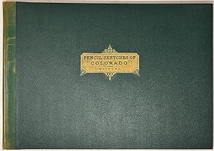
Pencil sketches of Colorado, its cities, principal towns and mountain scenery
Verlag: Alfred E. Matthews, 1866
Anbieter: Arader Galleries - AraderNYC, New York, NY, USA
Verkäuferbewertung 5 von 5 Sternen
Erstausgabe
Hardcover. Zustand: Very Good. 1st Edition. THE REESE COPY. New York: Alfred E. Mathews, 1866. First edition. Oblong folio. 20th-century quarter calf to style over green pebbled cloth boards. Title and author gilt to the front board. With 36 scenes on 23 tinted lithographed plates. Spine faded. Head and tail worn. Margins of 5 plates repaired with tape, beginning with the frontispiece. Heavy foxing and offsetting throughout the plates. Final leaf chipped. Pencil ownership inscription of "May C. Mathew-Bishop"(?) on the title-page. Alfred Edward Mathews (1831-1874) emigrated to the U.S. from England and became an itinerant bookseller and artist. He came to Colorado in 1865, having honed his illustrative skills as a Union soldier during the Civil War. He sought to present the awesome natural beauty of Colorado, as well as mining interests there. His documentary illustrations of the American West are accurate and attractive, among the earliest and most important of his time. Julius Bien, an American lithographer originally from Germany, was a specialist in chromolithography. Based in New York City, he printed a broad array of topics and maps, including a lithographed edition of John J. Audubon's The Birds of America. From the collection of William S. Reese (1955-2018), who was one of the great Americana booksellers. His firm continues to trade in New Haven. After his death, Christie's New York sold his private collection (24-25 May 2022; the present item was lot 260).
-
Report of the United States Geological Exploration of the Fortieth Parallel Made by Order of the Secretary of War According to Acts of Congress of March 2, 1867, and March 3, 1869, Under the Direction of Brig. and Bvt. Major General A. A. Humphreys, Chief of Engineers, By Clarence King, U. S. Geologist (Volumes I-VII); Atlas Accompanying Volume III on Mining Industry
Verlag: Government Printing Office; Julius Bien, Washington, D.C., 1880
Anbieter: Ken Sanders Rare Books, ABAA, Salt Lake City, UT, USA
Verbandsmitglied: ABAA ILAB IOBA RMABA
Verkäuferbewertung 5 von 5 Sternen
Erstausgabe
Hardcover. Zustand: Very good. Julius Bien (illustrator). First edition. Professional Papers of the Engineer Department, U. S. Army. No. 18. Seven volumes plus one atlas. Does not have the general atlas. Quarto [30 cm] Volume 1 is bound in 3/4 leather (with some additional skillful restoration work to the binding and new endbands). The remaining volumes are in the publisher's original green cloth. Volume 3 once belonged to The Long Island Historical Society (with deaccession stamp on title page). Volumes 4 and 7 have been professionally rebacked, and the hinges of volume 7 have been expertly reinforced. The spine of volume 6 has been skillfully restored at the spine ends and along the joints. This volume also has new endbands and Japanese tissue has been applied to the rear hinge. Overall the set shows moderate wear to the spine and boards. The wear at the extremities includes occasional chipping to the cloth and periodic exposure of the underlying boards. There are only very sporadic cracks in the text blocks. Internally very good with plates having little or no foxing. Several pages have small ink stamps from private clubs and booksellers. Volumes include: Vol. I: Systematic Geology by Clarence King (1878); Vol. II: Descriptive Geology by Arnold Hague and S. F. Emmons (1877); Vol. III: Mining Industry by James D. Hague (1870); Vol. IV: Paleontology and Ornithology by Meek, Hall, Whitfield, and Ridgway (1877); Vol. V: Botany by Sereno Watson, et al., (1871); Vol. VI, Microscopical Petrography by Ferdinand Zirkel (1876). Vol. VII: Odontornithes: A Monograph on the Extinct Toothed Birds of North America (1880). ****The preliminary pages, including the title, are those belonging to volume 2, however this is really volume 7 (This volume opens with p. 1 of the introduction). All plates and maps are present in each volume. Plate II in volume 7 is present in duplicate. There are tiny pin-size holes in the corner margins of the plates in this volume as well. The atlas volume is an oblong elephant folio, in original 3/4 brown morocco over red-brown cloth, with cover title in gilt (1" loss from head of backstrip and scuffing to the extremities of the boards). 14 plates, all but one in color. Bartlett, Great Surveys of the American West. One of the four major geological surveys of the western United States which took place in the years following the Civil War. This early monumental survey took place in 1867, under the direction of Clarence King (1842-1901). King, a graduate of Yale's Sheffield Scientific School, was only 25 years old when he was appointed Geologist in charge of the exploration along the 40th Parallel, which spanned from Eastern Colorado to California. This expedition represented the first major attempt to map the area in detail, and was one of the first expeditions to use the medium of photography to capture images and activities of the expedition. Timothy O'Sullivan (1840-1882), known for his images of the Civil War, was the photographer for the King survey. His photographs were subsequently reproduced in lithograph form by Julius Bien for inclusion in the published volumes reporting on the expedition. Many of O'Sullivan's original photographs from the 40th Parallel expedition are now in the collection of The George Eastman House in New York. The collection represents a historically and culturally important archive depicting the American West. In 1879, the United States Geological Survey was established and appointed Clarence King its first director. In 1881, King resigned this position to pursue other scientific interests leaving John Wesley Powell (1834-1902) as his successor. "King's Fortieth Parallel Survey materially improved the reputation of American science abroad, and set an example of accuracy and scholarship at home at a time when such an example was sorely needed. That such a survey should have taken place in an otherwise corrupt and barren era in our national life (1867-79) is also of some significance. Finally, as a personal achievement, the Fortieth Parallel Survey ranks as a.
-
Atlas of the State of New Hampshire.
Verlag: New York: Comstock & Cline, 1877., 1877
Anbieter: Arader Galleries - AraderNYC, New York, NY, USA
Verkäuferbewertung 5 von 5 Sternen
Erstausgabe
Hardcover. 1st Edition. Folio, (17 5/8 x 14 3/8 inches). Fine folding lithographed map of Coos County, 10 double-page maps, 12 single-page maps, most with original hand-color. Contemporary half straight-grained brown morocco, blue pebbled cloth, gilt (extremities a bit rubbed and worn). First edition. Double-page maps include: Geological Map of New Hampshire, Railroad Map of the United States, New England, New Hampshire and Vermont, Carroll County, Grafton County, Merrimack County, Cheshire County, Hillsborough County, and Rockingham County. "In 1853 [Walling] entered on his life work as a cartographer, and between that date and 1870 did a great work in the preparation of maps. His work extended over a large part of the Northern states. He prepared and published the well-known map of Massachusetts, which was the product in part of Borden's survey and in part the result of his own painstaking labor. About 1870 he became a professor of mathematics in Lafayette college, which office he retained for two years. For some years thereafter he was an assistant in the United States coast survey. Having acquired an interest in geological problems, he then became an officer of the national geological survey" (obituary, Cambridge Tribune, 1888). Hitchcock "served as New Hampshire State Geologist from 1868 to 1878 and taught at Dartmouth College from 1868 to 1908, holding the Hall Professorship of Geology and Mineralogy. Hitchcock's survey produced a three volume work, 'The Geology of New Hampshire' (1874-1878) and the folio, 'Atlas accompanying the report on the geology of New Hampshire.' The maps in the atlas comprise the first detailed, comprehensive map of the bedrock and surfacial geology of the state. Hitchcock used to name the rock units and designated their 'type localities.' Most of these rock formation names are still in use. In addition to geology, he contributed to a wide range of fields including fieldwork in paleontology, bedrock and glaciology, economic geology, and volcanology" (Dartmouth College Special Collections Library online). Phillips 2136.
-

City of Albany
Verlag: Julius Bien & Co, New York, 1895
Anbieter: Argosy Book Store, ABAA, ILAB, New York, NY, USA
Verkäuferbewertung 5 von 5 Sternen
unbound. Zustand: very good. City plan. Color lithograph. 18" x 24.25". Shows some staining and small chips at edges, image unaffected. In very good condition. Albany is the capital city of New York State. Julius Bien (1826-1909) was an American lithographic printer and cartographer based in New York City. During the course of the second half of the 19th century, he produced thousands of maps for both public and private publishers. Some of his most notable commissions were for the U.S. government, including many geological maps that redefined the cartographic visualization of geology. Bien's prolific output and contributions to the development of chromolithography make him one of the most significant map printers of his time.
-
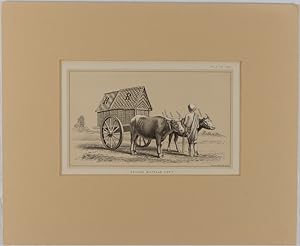
Ceylon Buffalo Cart.
Verlag: (Government Printing Office). (1887)., (Washington)., 1887
Anbieter: Asia Bookroom ANZAAB/ILAB, Canberra, ACT, Australien
Verkäuferbewertung 5 von 5 Sternen
Chromolithograph,11.3 x 18.8 cm (plus captions), 14.1 x 22.9 cm (sheet), margins toned two corners chipped with no loss to the image, in very good condition, preserved in a modern window mount. Fine lithograph by the renowned American lithographer Julius Bien (1826-1909). This illustration of Sinhalese cattle was included in an extensive United States consular report on dairy farming. Bien was the first president of the US National Lithographers' Association and was noted for his artistry and precision, pioneering chromolithography and noted for his edition of Audubon's Birds of America.
-
The Atlas to Accompany the Official Records of the Union and Confederate Armies, 1861-1865: Plate X.Arkansas & Tenn
Verlag: Julius Bien & Co, New York, 1895
Anbieter: Argosy Book Store, ABAA, ILAB, New York, NY, USA
Verkäuferbewertung 5 von 5 Sternen
unbound. Map. Color lithograph. Sheet measures 18 1/2" x 29 1/2" Collection of inset maps depicting the positions of both Union and Confederate armies during the Battle of Pea Ridge, the Battle at Shiloh, and more. The largest map on the page depict a portion of the Mississippi River where rebel armies built fortifications as well as how the Union attacked those forts. Beyond this historical information, the map is highly detailed in itself, with cities, capitals, railroads, canals, towns, villages, and forts labeled. The maps appeared as plate X in "The Atlas to Accompany the Official Records of the Union and Confederate Armies, 1861-1865." Chips to margins but does not affect image. Folded as issued. This map is a wonderful piece that boldly documents American history. Julius Bien (1826-1909) was an American lithographic printer and cartographer based in New York City. During the course of the second half of the 19th century, he produced thousands of maps for both public and private publishers. Some of his most notable commissions were for the U.S. government, including many geological maps that redefined the cartographic visualization of geology. Bien's prolific output and contributions to the development of chromo-lithography make him one of the most significant map printers of his time. This is a great example of his fine work.
-

The Atlas to Accompany the Official Records of the Union and Confederate Armies, 1861-1865: Plate IX. West Virginia
Verlag: Julius Bien & Co, New York, 1895
Anbieter: Argosy Book Store, ABAA, ILAB, New York, NY, USA
Verkäuferbewertung 5 von 5 Sternen
unbound. Map. Color lithograph. Sheet measures 18 1/2" x 29 1/2" Three maps on a single page depicting the area around the Gauley River and the military activity around it in 1861. Blue lines for the Union and red for the Confederacy show the geographical location of the various armies. Beyond this historical information, the map is highly detailed in itself, with cities, capitals, railroads, canals, towns, villages, and forts labeled. The maps appeared as plate X in "The Atlas to Accompany the Official Records of the Union and Confederate Armies, 1861-1865." There is a chip to the top center told, as pictured. Folded as issued. This map is a wonderful piece that boldly documents American history. Julius Bien (1826-1909) was an American lithographic printer and cartographer based in New York City. During the course of the second half of the 19th century, he produced thousands of maps for both public and private publishers. Some of his most notable commissions were for the U.S. government, including many geological maps that redefined the cartographic visualization of geology. Bien's prolific output and contributions to the development of chromo-lithography make him one of the most significant map printers of his time. This is a great example of his fine work.
-

Reed Orgnas. 141 / Oil Presses and mats.
Verlag: Artist: Bien/Julius & Co Photo-lith NY ( - ) New York ca : 1888, 1888
Anbieter: Antique Sommer& Sapunaru KG, München, Deutschland
Verkäuferbewertung 4 von 5 Sternen

Kunst / Grafik / Poster
Technic: Wood engraving, colorit: original colored, condition: Perfect condition, size (in cm): 43 x 33,5 cm, Collector's sheet with 8 different reed organs, such as No. 1 Aolen, Enlish A. D. 1829; No. 2 Harmonicum, A. D. 1840; No. 3 U. S. Patent, Exhaust, A. D. 1864, etc. On the reverse side with 10 illustrations in b/w of oil presses, mats or squeezing machines.
-

The Atlas to Accompany the Official Records of the Union and Confederate Armies, 1861-1865: Plate XI
Verlag: Julius Bien & Co, New York, 1895
Anbieter: Argosy Book Store, ABAA, ILAB, New York, NY, USA
Verkäuferbewertung 5 von 5 Sternen
unbound. Map. Color lithograph. Sheet measures 18 1/2" x 29 1/2" This collection of inset maps relating to the American Civil War's twin Forts Donelson and Henry includes seven images, sketches and maps, of operations between Feb. 4 and Mar. 10, 1862. The insets include "Plan of Fort Henry and its Outworks"; "Plan of Fort Donelson and its Outworks"; "Sketch showing the Relative Positions of Fort Henry and Fort Donelson"; "Military Map of the Country between the Tennessee and Cumberland"; "Fort Donelson and the Positions of the 1st Division During the Siege Feb 12-16, 1862"; and two untitled battlefield sketches. Blue lines for the Union and red for the Confederacy show the geographical location of the various armies. Dates and generals' names are also provided. Situated on the Tennessee and Cumberland Rivers respectively, Union armies attacked from the water at Forts Henry and Donelson and won, securing access to water travel and further weakening the Confederate army's control of the Tennessee River. Beyond this historical information, the map is highly detailed in itself, with cities, capitals, railroads, canals, towns, villages, and forts labeled. The maps appeared as plate XI in "The Atlas to Accompany the Official Records of the Union and Confederate Armies, 1861-1865." Folded as issued. There are a few small tears to the bottom and righthand edges of the sheet that do not affect the image. This map is a wonderful piece that boldly documents American history. Julius Bien (1826-1909) was an American lithographic printer and cartographer based in New York City. During the course of the second half of the 19th century, he produced thousands of maps for both public and private publishers. Some of his most notable commissions were for the U.S. government, including many geological maps that redefined the cartographic visualization of geology. Bien's prolific output and contributions to the development of chromo-lithography make him one of the most significant map printers of his time. This is a great example of his fine work.
-

Part of the Map of the Military Department of Southeastern Virginia and Fort Monroe
Verlag: Julius Bien & Co, New York, 1895
Anbieter: Argosy Book Store, ABAA, ILAB, New York, NY, USA
Verkäuferbewertung 5 von 5 Sternen
unbound. Map. Color lithograph. Sheet measures 18 1/2" x 29 1/2" This beautifully detailed map appeared as Plate XVII in "The Atlas to Accompany the Official Records of the Union and Confederate Armies", 1861-1865. Full title reads "Part of the Map of the Military Department of Southeastern Virginia and Fort Monroe Showing the Approaches to Richmond and Petersburg Compiled in the Bureau of Topographical Engineers of the War Department, 1861, with additions and corrections from. 1862". There are two small inset maps showing the Picket Line and Reconnaissance toward Lee's Mill, VA on April 28, 1862. Union and Confederate Forces' lines are denoted in blue and red respectively. Rivers, roads, railroads, forts, churches, mills, meetinghouses and other landmarks are labeled with extreme detail, providing an in-depth view of Southeastern Virginia during this time. Fort Monroe is significant for its role as an early flocking point for freed slaves, and Confederate president Jefferson Davis was imprisoned there after the end of the Civil War. Fold as issued. Small tear to top edge, does not affect the image. Julius Bien (1826-1909) was an American lithographic printer and cartographer based in New York City. During the course of the second half of the 19th century, he produced thousands of maps for both public and private publishers. Some of his most notable commissions were for the U.S. government, including many geological maps that redefined the cartographic visualization of geology. Bien's prolific output and contributions to the development of chromo-lithography make him one of the most significant map printers of his time. This is a great example of his fine work.
-
Map Illustrating the Second Epoch of the Atlanta Campaign
Verlag: Julius Bien & Co, New York, 1895
Anbieter: Argosy Book Store, ABAA, ILAB, New York, NY, USA
Verkäuferbewertung 5 von 5 Sternen
unbound. Map. Color lithograph. Sheet measures 18 1/2" x 29 1/2" This collection of inset maps relating to the American Civil War's Atlanta Campaign includes a map of the Seond Epoch of the Atlanta Campaign, a map showing the March of the 15th Army Corps through Northern Georgia, and four plates showing positions of the 15th Army Corps in Resaca, GA; Dallas, GA; Newhope Church, Ga; and Kenesaw Mountain, GA. Blue lines for the Union and red for the Confederacy show the geographical location of the various armies. Dates and generals' names are also provided. These battles provided footing for the Union army's eventual seizure of Atlanta, which boosted Northern morale and led to Lincoln's re-election in 1864. Beyond this historical information, the map is highly detailed in itself, with cities, capitals, railroads, canals, towns, villages, and forts labeled. The maps appeared as plate LVIII in "The Atlas to Accompany the Official Records of the Union and Confederate Armies, 1861-1865." Folded as issued. There are a few small tears to the upper edge of the sheet that do not affect the image. This map is a wonderful piece that boldly documents American history. Julius Bien (1826-1909) was an American lithographic printer and cartographer based in New York City. During the course of the second half of the 19th century, he produced thousands of maps for both public and private publishers. Some of his most notable commissions were for the U.S. government, including many geological maps that redefined the cartographic visualization of geology. Bien's prolific output and contributions to the development of chromo-lithography make him one of the most significant map printers of his time. This is a great example of his fine work.
-

Map Illustrating the First Epoch of The Atlanta Campaign
Verlag: Julius Bien & Co.; US War Department, New York, 1895
Anbieter: Argosy Book Store, ABAA, ILAB, New York, NY, USA
Verkäuferbewertung 5 von 5 Sternen
Map. Color lithograph. Image measures 16 1/2" x 27 3/8" This fascinating sheet from "Atlas to Accompany the Official Records of the Union and Confederate Armies (1861-1865)" features 3 maps illustrating various operations between Chattanooga, Tennessee and Atlanta, Georgia during the Civil War. The map titles are as follows: 1. Map Illustrating The Operations of the Army Under Command of General W. T. Sherman, in Georgia; 2. Map Illustrating the First epoch of the Atlanta Campaign; 3. Map Showing the Roads Followed by the Amy of the Tennessee in its March from Chattanooga, Tenn. to Atlanta, GA. Under the Command of the Late Maj. Gen. J. B. McPherson and Maj. Gen. O.O. Howard. The maps show rivers, canals, towns, roads, and railways, as well as positions and routes of both armies, with blue lines for the Union and red for the Confederate forces. Relief is shown by both hachures and contour lines. The beautifully precise color topographical features showcase Bien's lithographic skill and make this map visually stunning. Minor tears at margins, not affecting the image. This map is a wonderful piece that boldly documents American history. Julius Bien (1826-1909) was an American lithographic printer and cartographer based in New York City. During the course of the second half of the 19th century, he produced thousands of maps for both public and private publishers. Some of his most notable commissions were for the U.S. government, including many geological maps that redefined the cartographic visualization of geology. Bien's prolific output and contributions to the development of chromolithography make him one of the most significant map printers of his time.
-

The Atlas to Accompany the Official Records of the Union and Confederate Armies, 1861-1865: Plate CXII.Tenn. & Ala
Verlag: Julius Bien & Co, New York, 1895
Anbieter: Argosy Book Store, ABAA, ILAB, New York, NY, USA
Verkäuferbewertung 5 von 5 Sternen
unbound. Map. Color lithograph. Sheet measures 18 1/2" x 29 1/2" Collection of inset maps and defense plans in Nashville, Chattanooga, and Murfreesborough, Tenn., and nearby towns in Alabama. The largest map on the page is a detailed topographical sketch of Fortress Rosencrans, a powerful Union supply depot. Also included is a map of Defenses of Nashville, TN with detailed notation of Forts and Union army lines. Each inset map depicts the Nashville & Chattanooga Railroad, rivers, and other topographical details. Dates and generals' names are also provided. The maps appeared as plate CXII in "The Atlas to Accompany the Official Records of the Union and Confederate Armies, 1861-1865." Chips to margins but does not affect image. Folded as issued. This map is a wonderful piece that boldly documents American history. Julius Bien (1826-1909) was an American lithographic printer and cartographer based in New York City. During the course of the second half of the 19th century, he produced thousands of maps for both public and private publishers. Some of his most notable commissions were for the U.S. government, including many geological maps that redefined the cartographic visualization of geology. Bien's prolific output and contributions to the development of chromo-lithography make him one of the most significant map printers of his time. This is a great example of his fine work.
-

The Atlas to Accompany the Official Records of the Union and Confederate Armies, 1861-1865: Plate CXIV.TENN
Verlag: Julius Bien & Co, New York, 1895
Anbieter: Argosy Book Store, ABAA, ILAB, New York, NY, USA
Verkäuferbewertung 5 von 5 Sternen
unbound. Map. Color lithograph. Sheet measures 18 1/2" x 29 1/2" Five defense plans of various Tennessee Confederate Forts and one map of Memphis And Its Environs on a single sheet. Blue lines for the Union and red for the Confederacy show the geographical location of the various armies. Fort Donelson is depicted in blue, representing one of the first major Union victories in 1862. A plan of Fort Pickering is replete with detailed positions and calibers of guns located within the fort. Dates and generals' names are also provided. Beyond this historical information, the map is highly detailed in itself, with railroads, hospitals, cemeteries, rivers, and forts labeled. The maps appeared as plate CXIV in "The Atlas to Accompany the Official Records of the Union and Confederate Armies, 1861-1865." It is in excellent condition. Folded as issued. This map is a wonderful piece that boldly documents American history. Julius Bien (1826-1909) was an American lithographic printer and cartographer based in New York City. During the course of the second half of the 19th century, he produced thousands of maps for both public and private publishers. Some of his most notable commissions were for the U.S. government, including many geological maps that redefined the cartographic visualization of geology. Bien's prolific output and contributions to the development of chromo-lithography make him one of the most significant map printers of his time. This is a great example of his fine work.
-

The Atlas to Accompany the Official Records of the Union and Confederate Armies, 1861-1865: Plate CXI
Verlag: Julius Bien & Co, New York, 1895
Anbieter: Argosy Book Store, ABAA, ILAB, New York, NY, USA
Verkäuferbewertung 5 von 5 Sternen
unbound. Map. Color lithograph. Sheet measures 18 1/2" x 29 1/2" This collection of inset maps includes battlefield maps, fortification plans, and positions of Confederate and Union armies in Tennessee, Virginia, and Georgia. Blue lines for the Union and red for the Confederacy show the geographical location of the various armies. The largest inset depicts the Defenses of Chattanooga, Tenn. Dates and generals' names are also provided. Beyond this historical information, the map is highly detailed in itself, with cities, capitals, railroads, canals, towns, villages, and forts labeled. The maps appeared as plate CXI in "The Atlas to Accompany the Official Records of the Union and Confederate Armies, 1861-1865." Folded as issued. This map is a wonderful piece that boldly documents American history. Julius Bien (1826-1909) was an American lithographic printer and cartographer based in New York City. During the course of the second half of the 19th century, he produced thousands of maps for both public and private publishers. Some of his most notable commissions were for the U.S. government, including many geological maps that redefined the cartographic visualization of geology. Bien's prolific output and contributions to the development of chromo-lithography make him one of the most significant map printers of his time. This is a great example of his fine work.
-

Reconnaissance of Secession Works and Plan of Siege of Yorktown; Made Under Orders of Gen'l Barnard and Maj. Humphreys
Verlag: Julius Bien & Co, New York, 1895
Anbieter: Argosy Book Store, ABAA, ILAB, New York, NY, USA
Verkäuferbewertung 5 von 5 Sternen
unbound. Map. Color lithograph. Sheet measures 18 1/2" x 29 1/2" Three maps on a single page depicting the Siege of Yorktown, the Battlefield of Shiloh, and a Topographical Sketch of the Line of Operations of the Army of Ohio in April and May of 1862. Blue lines for the Union and red for the Confederacy show the geographical location of the various armies. While the siege of Yorktown ended inconclusively, the Battle of Shiloh was an important Union victory that secured their advancement into Mississippi and badly hurt the Confederate Army's morale. At the time, Shiloh was the deadliest battle fought in North America to date. Beyond this historical information, the map is highly detailed in itself, with railroads, towns, rivers, orchards, roads, and forts and headquarters labeled. The maps appeared as plate XIV in "The Atlas to Accompany the Official Records of the Union and Confederate Armies, 1861-1865." There are a few small tears to the bottom edge that do not affect the image, as pictured. Folded as issued. This map is a wonderful piece that boldly documents American history. Julius Bien (1826-1909) was an American lithographic printer and cartographer based in New York City. During the course of the second half of the 19th century, he produced thousands of maps for both public and private publishers. Some of his most notable commissions were for the U.S. government, including many geological maps that redefined the cartographic visualization of geology. Bien's prolific output and contributions to the development of chromo-lithography make him one of the most significant map printers of his time. This is a great example of his fine work.
-

Map of the Battle-Grounds in the Vicinity of Richmond, VA
Verlag: Julius Bien & Co, New York, 1895
Anbieter: Argosy Book Store, ABAA, ILAB, New York, NY, USA
Verkäuferbewertung 5 von 5 Sternen
unbound. Map. Color lithograph. Sheet measures 18 1/2" x 29 1/2" This beautifully detailed map appeared as Plate XX in "The Atlas to Accompany the Official Records of the Union and Confederate Armies", 1861-1865. "Map of the Battle-Grounds in the Vicinity of Richmond, VA." covers the majority of the sheet, and three smaller insets entitled "Reconnaissance of Part of the Rebel Works in front of Williamsburg, evacuated May 6th 1862" ; "Sketch of the Battle-Field and Confederate Works in Front of Williamsburg, VA. May 5th, 1862"; and "Battle-Field and Rebel Works in front of Williamsburg, VA. Battle of 5th May 1862" cover the remainder of the page. Union and Confederate Forces' lines are denoted in blue and red respectively. Rivers, roads, railroads, forts, churches, mills, meetinghouses and other landmarks are labeled with extreme detail. The beautiful color lithography shines depicting details such as felled trees and ravines. Fold as issued. Small tear to bottom fold line, does not affect the image. Julius Bien (1826-1909) was an American lithographic printer and cartographer based in New York City. During the course of the second half of the 19th century, he produced thousands of maps for both public and private publishers. Some of his most notable commissions were for the U.S. government, including many geological maps that redefined the cartographic visualization of geology. Bien's prolific output and contributions to the development of chromo-lithography make him one of the most significant map printers of his time. This is a great example of his fine work.
-

Approaches to New Orleans; Battle of Atlanta; Maps of Spanish Fort
Verlag: Julius Bien & Co.; US War Department, New York, 1895
Anbieter: Argosy Book Store, ABAA, ILAB, New York, NY, USA
Verkäuferbewertung 5 von 5 Sternen
Map. Color lithograph. Image measures 16 1/2" x 27 3/8" This fascinating sheet from "Atlas to Accompany the Official Records of the Union and Confederate Armies (1861-1865)" features 11 maps illustrating various campaigns during the Civil War. The map titles are as follows: 1. Department of the Gulf Map No. 5, Approaches to New Orleans; 3. Position of Army of Tennessee near Atlanta, GA; 5. Diagrams illustrating the Different Positions Occupied by the 4th Division, 17th Army Corps, during the Battle of Atlanta, GA.; 6. Part of Paulding County; 7. Section of a Map showing the Lines near New Hope Church, GA.; 8. Topographical Sketch of the Position of the Second Division, 14th Army Corps in front of Savannah, GA.; 9. Map of the Vicinity of Mechanicsville, VA.; and 4, 10, and 11 showing Maps of Spanish Fort, Ala. during the siege of 1865. The maps show rivers, canals, towns, roads, and railways, as well as positions and routes of both armies, with blue lines for the Union and red for the Confederate forces. Relief is shown by both hachures and contour lines. This map is a wonderful piece that boldly documents American history. In good condition, with an archival tape repair to split centerfold. Julius Bien (1826-1909) was an American lithographic printer and cartographer based in New York City. During the course of the second half of the 19th century, he produced thousands of maps for both public and private publishers. Some of his most notable commissions were for the U.S. government, including many geological maps that redefined the cartographic visualization of geology. Bien's prolific output and contributions to the development of chromolithography make him one of the most significant map printers of his time.
-

General Topographical Map, Sheet XI
Verlag: Julius Bien & Co, New York, 1895
Anbieter: Argosy Book Store, ABAA, ILAB, New York, NY, USA
Verkäuferbewertung 5 von 5 Sternen
unbound. Map. Color lithograph. Sheet measures 18 1/2" x 29 1/2" This map appeared as Plate CXLVI in "The Atlas to Accompany the Official Records of the Union and Confederate Armies, 1861-1865. Northern and central Florida are displayed, extending as far north as Jacksonville and as far south as Clearwater Harbor. An inset map of southern Florida is included in the lower left corner. The map is highly detailed, with cities, rivers, towns, post offices, villages, railroads, vegetation and forts labeled. Swamps are depicted pictorially, and relief is shown by hachure. Florida was a vital source of beef and salt for the Confederacy. Florida beef became especially important after the Confederates lost control of the Mississippi River in 1864. With the flow of beef from Texas almost completely cut off, Florida%u2019s vast supply of cattle became a critical food source for the Confederate Army.Folded as issued. This map wonderful piece that boldly documents American history. Julius Bien (1826-1909) was an American lithographic printer and cartographer based in New York City. During the course of the second half of the 19th century, he produced thousands of maps for both public and private publishers. Some of his most notable commissions were for the U.S. government, including many geological maps that redefined the cartographic visualization of geology. Bien's prolific output and contributions to the development of chromo-lithography make him one of the most significant map printers of his time. This is a great example of his fine work.
-
General Topographical Map, Sheet XXIV
Verlag: Julius Bien & Co, New York, 1895
Anbieter: Argosy Book Store, ABAA, ILAB, New York, NY, USA
Verkäuferbewertung 5 von 5 Sternen
unbound. Map. Color lithograph. Sheet measures 18 1/2" x 29 1/2" This map appeared as Plate CLX in "The Atlas to Accompany the Official Records of the Union and Confederate Armies, 1861-1865." It depicts the border region of Oklahoma (Indian Territory), Arkansas, and Texas. The area labeled as Indian Territory is subdivided by nation - showing Cherokee, Creek, Quapaws, Senecas and Shawnees, and Senecas Proper. The map is highly detailed, with cities, rivers, towns, post offices, villages, railroads, and forts labeled. Swamps are depicted pictorially, and relief is shown by hachure. Map is in excellent condition. Folded as issued.This map wonderful piece that boldly documents American history. Julius Bien (1826-1909) was an American lithographic printer and cartographer based in New York City. During the course of the second half of the 19th century, he produced thousands of maps for both public and private publishers. Some of his most notable commissions were for the U.S. government, including many geological maps that redefined the cartographic visualization of geology. Bien's prolific output and contributions to the development of chromo-lithography make him one of the most significant map printers of his time. This is a great example of his fine work.
-
General Topographical Map, Sheet XXV
Verlag: Julius Bien & Co, New York, 1895
Anbieter: Argosy Book Store, ABAA, ILAB, New York, NY, USA
Verkäuferbewertung 5 von 5 Sternen
unbound. Map. Color lithograph. Sheet measures 18 1/2" x 29 1/2" This map appeared as Plate CLX in "The Atlas to Accompany the Official Records of the Union and Confederate Armies, 1861-1865." It depicts the region where Kansas, Missouri, Arkansas, and Oklahoma (Indian Territory) meet. The area labeled as Indian Territory is subdivided by nation - showing Cherokee, Creek, Quapaws, Senecas and Shawnees, and Senecas Proper. The map is highly detailed, with railroads, canals, towns, post offices, villages, and forts labeled. Swamps are depicted pictorially, and relief is shown by hachure. In very good condition, with minor chips and tears at margins. Folded as issued. This map wonderful piece that boldly documents American history. Julius Bien (1826-1909) was an American lithographic printer and cartographer based in New York City. During the course of the second half of the 19th century, he produced thousands of maps for both public and private publishers. Some of his most notable commissions were for the U.S. government, including many geological maps that redefined the cartographic visualization of geology. Bien's prolific output and contributions to the development of chromo-lithography make him one of the most significant map printers of his time. This is a great example of his fine work.
-
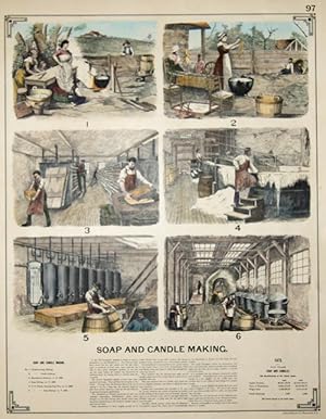
Soap and candle making. 97 / Stone Sawing. 98
Verlag: Artist: Bien/Julius & Co Photo-lith NY ( - ) New York ca : 1888, 1888
Anbieter: Antique Sommer& Sapunaru KG, München, Deutschland
Verkäuferbewertung 4 von 5 Sternen
Kunst / Grafik / Poster
Technic: Lithography, colorit: colored, condition: Perfect condition, size (in cm): 44 x 34 cm, View shows 6 views of a soap and candle factory, on the back 9 views of a stone sawmill, by Benjamin Butterworth, The Growth of Industrial Art, 1888, p. 97 and p. 98.
-
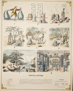
Distillation. 50 / Bale and Tighteners. 49
Verlag: Artist: Bien/Julius & Co Photo-lith NY ( - ) New York ca : 1888, 1888
Anbieter: Antique Sommer& Sapunaru KG, München, Deutschland
Verkäuferbewertung 4 von 5 Sternen
Kunst / Grafik / Poster
Technic: Lithography, colorit: colored, condition: Perfect condition, size (in cm): 43 x 33,5 cm, 8 views of spirit distillation and distilleries, on the back 12 views of various bale presses or baling machines, by Benjamin Butterworth, The Growth of Industrial Art, 1888, pp. 50 and 49.
-

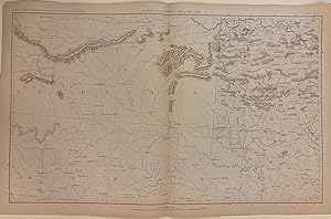
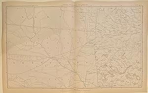
Map of the Territory of the United States From The Mississippi to the Pacific Ocean; ordered by Jeff'n Davis, Secretary of War to accompany the reports of the explorations for a railroad route.
Verlag: United States War Department. 1854-5-6-7, Washington DC, United States, 1854
Anbieter: Alexandre Antique Prints, Maps & Books, Toronto, ON, Kanada
Verkäuferbewertung 4 von 5 Sternen
Karte
An important mid-19th century map of Central and Western USA , Size : 1078x1177 (mm), 42.44x46.34 (Inches), Hand Colored Very Good, backed on acid free linen for long term preservation.