
Gesamtpreis (1 Artikel Artikel):
Versandziel:

bertius petrus (457 Ergebnisse)
Direkt zu den wichtigsten Suchergebnissen
Produktart
- Alle Produktarten
- Bücher (153)
- Magazine & Zeitschriften
- Comics
- Noten
- Kunst, Grafik & Poster (103)
- Fotografien
- Karten (201)
-
Manuskripte &
Papierantiquitäten
Zustand
- Alle
- Neu
- Antiquarisch/Gebraucht
Einband
Weitere Eigenschaften
- Erstausgabe (6)
- Signiert (1)
- Schutzumschlag
- Angebotsfoto (430)
Land des Verkäufers
Verkäuferbewertung
-

Wesel. Gesamtansicht. Kupferstich aus dem Städte-Atlas von Bertius, ca.
Erscheinungsdatum: 1630
Kunst / Grafik / Poster
Zustand: Gut. 14,3 x 19,3 cm. Sprache: Deutsch Gewicht in Gramm: 100.
-

Zustand: Antiquarian. Leiden University Library, Leiden, 1995. (IX),(108),(XX)p. Paperback. Spine bit discoloured. Limited edition: 1 of 350 copies. 'Op 24 mei 1595 werd een nieuwe universiteitsbibliotheek in gebruik genomen: de hal van de Begijnkerk aan het Rapenburg, schuin tegenover het academiegebouw. Bij die gelegenheid werd de ' Nomenclator' gepresenteerd, de eerste gedrukte catalogus van een Europese instituutsbibliotheek. Vierhonderd jaar na deze public-relations stunt is van dit boekje nu een facsimile-editieverschenen. (.) De originele Nomenclator (.) was voor het functioneren van de bibliotheek niet van belang. (.) De Nomenclator diende een ander doel: hij werd als visitekaartje naar alle windstreken gestuurd om te laten zien: dit zijn wij, de Leidse Universiteit, hier kun je studeren, hier bevindt zich een grote openbare boekverzameling die alle onderwerpen omvat en die voor het geleerde publiek beschikbaar is.' (DIRK VAN DELFT, NRC, 01.07.1995). Antiquarian.
-
Palatinat Bavariae
Verlag: c. 1616, Amsterdam, 1616
Anbieter: Alexandre Antique Prints, Maps & Books, Toronto, ON, Kanada
Bewertung:

Karte
Zustand: Very Good. A detailed early map of present day Southern Germany during the early 17th century. Latin text on verso. , Size : 136x177 (mm), 5.35x6.97 (Inches), Original Hand Coloring.
-
Brandeburg et Pomerania
Verlag: c. 1616, Amsterdam, 1616
Anbieter: Alexandre Antique Prints, Maps & Books, Toronto, ON, Kanada
Bewertung:
Karte
Zustand: Very Good. A detailed early map of the present day states of Brandenburg and Berlin, Germany, during the early 17th century. Latin text on verso. , Size : 142x192 (mm), 5.59x7.56 (Inches), Original Hand Coloring.
-
Saxoniae
Verlag: c. 1616, Amsterdam, 1616
Anbieter: Alexandre Antique Prints, Maps & Books, Toronto, ON, Kanada
Bewertung:
Karte
Zustand: Very Good. A detailed early map of central Germany during the early 17th century. Latin text on verso. , Size : 142x190 (mm), 5.59x7.48 (Inches), Original Hand Coloring.
-
Palatinatus Rheni
Verlag: c. 1616, Amsterdam, 1616
Anbieter: Alexandre Antique Prints, Maps & Books, Toronto, ON, Kanada
Bewertung:
Karte
Zustand: Very Good. A detailed early map of present day France during the early 17th century. Latin text on verso. , Size : 142x178 (mm), 5.59x7.01 (Inches), Original Hand Coloring.
-
Lugduni Batavorum, apud Franciscum Raphelengium, 1595. [Reprint Leiden, 1995]. [140] pp. Softcover.Facsimile published in a limited edition of 350 copies on occasion of the 420th anniversary of the founding of Leiden University. - Reprint of: Nomenclator autorum omnium, quorum libri vel manuscripti, vel typis expressi exstant in Bibliotheca Academiae Lugduno-Batavae [.]. [auct. P. Bertio]. Lugduni Batavorum, apud Franciscum Raphelengium, 1595.
-
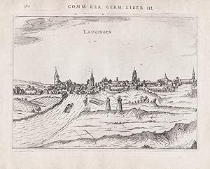
Laugingen" - Lauingen Donau Bayern Ansicht Gesamtansicht
Verlag: Amsterdam, 1616
Anbieter: Antiquariat Steffen Völkel GmbH, Seubersdorf, Deutschland
Bewertung:

Kunst / Grafik / Poster
OriginalKupferstich aus dem Städte-Atlas von Bertius von 1616. Rückseitig mit Text. -- Blattmasse: ca.18,5 x24 cm. -- gut erhalten. || Original copper engraving out of Bertius' city atlas from 1616. With text on verso. -- in very good condition. || Dies ist ein Original! - Kein Nachdruck! - Keine Kopie! -- This is an original! - No copy! - No reprint! la Gewicht in Gramm: 10.
-

Lucern" - Luzern Vierwaldstättersee Ansicht view
Verlag: Amsterdam, 1616
Anbieter: Antiquariat Steffen Völkel GmbH, Seubersdorf, Deutschland
Bewertung:
Kunst / Grafik / Poster
OriginalKupferstich aus dem Städte-Atlas von Bertius von 1616. Rückseitig mit Text. -- Blattmasse: ca.18,5 x24 cm. -- gut erhalten. || Original copper engraving out of Bertius' city atlas from 1616. With text on verso. -- in very good condition. || Dies ist ein Original! - Kein Nachdruck! - Keine Kopie! -- This is an original! - No copy! - No reprint! la Gewicht in Gramm: 10.
-

Raab" - Raab Györ Ungarn Danube Donau Ansicht view
Verlag: Amsterdam, 1616
Anbieter: Antiquariat Steffen Völkel GmbH, Seubersdorf, Deutschland
Bewertung:
Kunst / Grafik / Poster
OriginalKupferstich aus dem Städte-Atlas von Bertius von 1616. Rückseitig mit Text. -- Blattmasse: ca.18,5 x24 cm. -- gut erhalten. || Original copper engraving out of Bertius' city atlas from 1616. With text on verso. -- in very good condition. || Dies ist ein Original! - Kein Nachdruck! - Keine Kopie! -- This is an original! - No copy! - No reprint! la Gewicht in Gramm: 10.
-
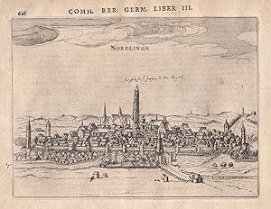
Nordlinga" - Nördlingen Gesamtansicht Ansicht view
Verlag: Amsterdam, 1616
Anbieter: Antiquariat Steffen Völkel GmbH, Seubersdorf, Deutschland
Bewertung:
Kunst / Grafik / Poster
originalKupferstich aus dem Städte-Atlas von Bertius von 1616 - rückseitig mit Text - Blattmasse: ca.23 x18 cm - mit kleiner handschriftlicher Anmerkung, sonst gut erhalten | original copper engraving out of Bertius' city atlas from 1616 - with text on back side - with small handwritten remark, otherwise in good condition. | Dies ist ein Original! - Kein Nachdruck! - Keine Kopie! -- This is an original! No copy! - No reprint! Sprache: Deutsch Gewicht in Gramm: 10.
-
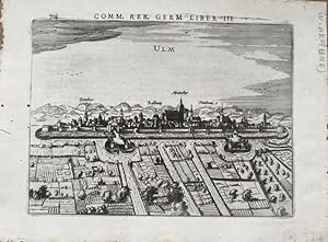
Ulm. Gesamtansicht. Original-Kupferstich aus dem Städtealbum von Bertius: Comm. Rer. Germ., Liber III. 14,5 x 19 cm (Darstellung), 18 x 24 cm (Blattgröße). Rückseitig mit Text.
Verlag: Amsterdam, 1616, 1616
Anbieter: Treptower Buecherkabinett Inh. Schultz Volha, Berlin, Deutschland
Bewertung:
Buch
Original Kupferstich in kräftigem Abdruck. Kleines Löchlein Himmel der Abb., kleine Wurmspuren im linken Außenrand, insgesamt gut erhalten. Graf Sprache: Deutsch Gewicht in Gramm: 2000.
-
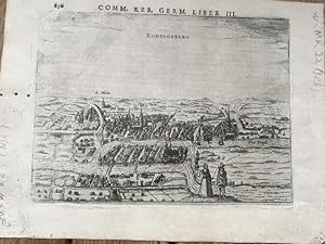
Königsberg (Koningsberg, Kaliningrad). Gesamtansicht. Original-Kupferstich aus dem Städtealbum von Bertius: Comm. Rer. Germ., Liber III. 14 x 19 cm (Darstellung), 18 x 24 cm (Blattgröße). Rückseitig mit Text.
Verlag: Amsterdam, 1616, 1616
Anbieter: Treptower Buecherkabinett Inh. Schultz Volha, Berlin, Deutschland
Bewertung:
Buch
Original Kupferstich, teils etwas schwacher Abdruck. Kleine Löchlein im linken Außenrand, insgesamt gut erhalten. Graf Sprache: Deutsch Gewicht in Gramm: 2000.
-

Landtshut" - Landshut Isar Ansicht view Gesamtansicht
Verlag: Amsterdam, 1616
Anbieter: Antiquariat Steffen Völkel GmbH, Seubersdorf, Deutschland
Bewertung:
Kunst / Grafik / Poster
OriginalKupferstich aus dem Städte-Atlas von Bertius von 1616. Rückseitig mit Text. -- Blattmasse: ca.18,5 x24 cm. -- gut erhalten. || Original copper engraving out of Bertius' city atlas from 1616. With text on verso. -- in very good condition. || Dies ist ein Original! - Kein Nachdruck! - Keine Kopie! -- This is an original! - No copy! - No reprint! la Gewicht in Gramm: 10.
-
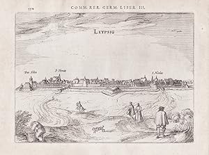
Leypsig" - Leipzig Gesamtansicht Ansicht view
Verlag: Amsterdam, 1616
Anbieter: Antiquariat Steffen Völkel GmbH, Seubersdorf, Deutschland
Bewertung:
Kunst / Grafik / Poster
OriginalKupferstich aus dem Städte-Atlas von Bertius von 1616. Rückseitig mit Text. -- Blattmasse: ca.18,5 x24 cm. -- gut erhalten. || Original copper engraving out of Bertius' city atlas from 1616. With text on verso. -- in very good condition. || Dies ist ein Original! - Kein Nachdruck! - Keine Kopie! -- This is an original! - No copy! - No reprint! la Gewicht in Gramm: 10.
-
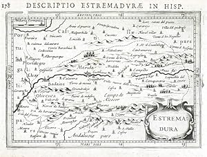
Estremadura
Verlag: Hondius, Jodocus Jr., Amsterdam, 1618
Extremadura. "Estremadura". Orig. copperplate engraving from P. Bertius' "Tabulae Geographicae .". Published in Amsterdam by J. Hondius Jr., 1616/18. With ornamental title-cartouche and Latin title ("Descriptio Estremadurae in Hisp.") above the map. 10:14 cm (4 x 5 1/2 inch.). Koeman III, map 6051:342, ed. 342:01 (1616/18 Tabulae). - A miniature map of Extremadura in the central-western part of the Iberian Peninsula in southwestern part of Spain. - Price includes the passe-partout.
-
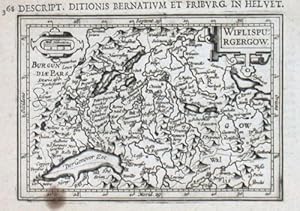
Wiflispurgergow
Verlag: Hondius, J., 1616
"Wiflispurgergow". copperplate engraving by P. Bertius published by J. Hondius, 1616-18. With small ornamental cartouche and "Mill. Helvetica". 9,5:13,5 cm. Koeman III, map 4920:342 (Avenches), ed. 342:01. Shows Lac Geneve, Bern, Friburg and environs.
-
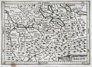
Argow
Verlag: Hondius, J., 1616
"Argow". copperplate engraving by P. Bertius published by J. Hondius, 1616-18. With small ornamental cartouche and "Miliare Helvet". 9,5:13,2 cm. Koeman III, map 4930:342, ed. 342:01.
-
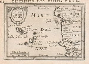
Insulae Capitis Viridis
Verlag: Hondius, J., 1616
Cape Verde Islands."Insulae Capitis Viridis". copperplate engraving by P. Bertius published by J. Hondius, 1616-18. With small ornamental cartouche and "Milliaria Germanica". 9,2:13 cm. Koeman III, map 8980:342, ed. 342:01 (1616/1618 Tabulae) - A miniature map of Cape Verde Islands.
-

Tunetanum Regnum
Verlag: Bertius, Petrus, 1616
Tunisia."Tunetanum Regnum". copperplate engraving by P. Bertius published by J. Hondius, 1616-18. With small ornamental cartouche. 9,3:13,3 cm (3 3/4 x 5 1/4 inch.). Koeman III, map 8630:342, ed. 342:01 - A miniature map of a region of today's Tunis and Algeria.
-
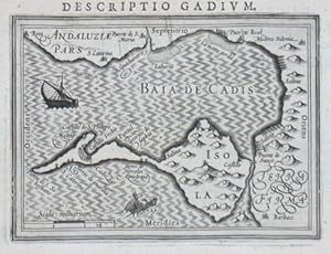
Baia de Cadis
Verlag: Hondius, Jodocus, 1616
"Baia de Cadis". copperplate engraving by P. Bertius published by J. Hondius, 1616-18. With a ship and a sea-creature. 9,2:12,8 cm. Koeman III, map 6115:342, ed. 342:01 (1616/1618 Tabulae) - A miniature map of the Bay of Cadiz. "Descriptio Gadium" engraved above the map.
-

Insulae Capitis Viridis
Verlag: Hondius, J., 1616
Cape Verde Islands."Insulae Capitis Viridis". copperplate engraving by P. Bertius published by J. Hondius, 1616-18. With small ornamental cartouche and "Milliaria Germanica". 9,2:13 cm. Koeman III, map 8980:342, ed. 342:01 (1616/1618 Tabulae) - A miniature map of Cape Verde Islands.
-
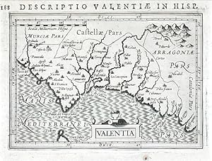
Valentia
Verlag: Hondius, Jodocus Jr., Amsterdam, 1618
Kingdom of Valencia. "Valentia". Orig. copperplate engraving from P. Bertius' "Tabulae Geographicae .". Published in Amsterdam by J. Hondius Jr., 1616/18. With ornamental title-cartouche and Latin title ("Descriptio Valnetiae in Hisp.") above the map. 9,5:13,5 cm (3 3/4 x 5 1/4 inch.). Koeman III, map 6155:342, ed. 342:01 (1616/18 Tabulae). - A miniature map of the Valencia province in the eastern part of Spain with the main city Valencia on the shore of the Mediterranean Sea. - Oriented to the West. - Price includes the passe-partout (23,5:26 cm).
-
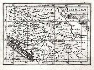
Illyricum
Verlag: Jodocus Hondius, Amsterdam, 1616
Karte
Kein Einband. Zustand: Sehr gut. Serbia, Bosnia, Slovenia, Croatia. "Illyricum". Orig. copperplate engraving from P. Bertius' "Tabulae Geographicae Contractae". Published by J. Hondius in Amsterdam, 1616-18. With ornamental title cartouche. 9,3:13,2 cm. Koeman III, map 7601:342, ed. 342:01 (1616-18 Tabulae). - A miniature map of the western part of the Balkan Peninsula - today the territory of Serbia (Belgrade), Bosnia, Slovenia and Croatia.
-
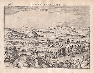
Lintz" - Linz Donau Gesamtansicht Ansicht view
Verlag: Amsterdam, 1616
Anbieter: Antiquariat Steffen Völkel GmbH, Seubersdorf, Deutschland
Bewertung:
Kunst / Grafik / Poster
originalKupferstich aus dem Städte-Atlas von Bertius von 1616 - rückseitig mit Text - Blattmasse: ca.23 x18 cm - gut erhalten | original copper engraving out of Bertius' city atlas from 1616 - with text on back side - good condition. | Dies ist ein Original! - Kein Nachdruck! - Keine Kopie! -- This is an original! No copy! - No reprint! Sprache: Deutsch Gewicht in Gramm: 10.
-
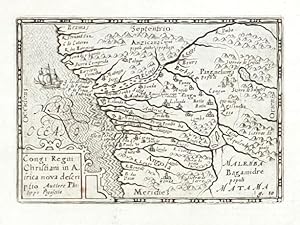
Congi Regni
Verlag: Visscher, Nicolaas Jansz., Amsterdam, 1649
Karte
Congo (Western Africa). "Congi Regni Christiani in Africa nova descriptio. Auctore Philippo Pigafetta". Orig. copper-engraving after P. Pigafetta's map of the region. Published by C. J. Visscher in Amsterdam, 1649 (in Tabulae Geographicae Contrare). With ornamental title-cartouche and a ship. 8,5:12 cm (3 1/4 x 4 3/4 inch.). Koeman III, map 8755:341, ed. 341:54 (1649, Tabulae, Visscher). - A decorative miniature map of the western part of Africa (today Gabon, Congo, Zaire, Angola) with depiction of Congo river basin.
-
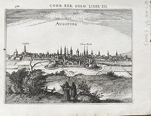
Augsburg (Augspurg). Gesamtansicht. Original-Kupferstich aus dem Städtealbum von Bertius: Comm. Rer. Germ., Liber III. 14,5 x 19,5 cm (Darstellung), 18,5 x 24 cm (Blattgröße). Rückseitig mit Text.
Verlag: Amsterdam, 1616, 1616
Anbieter: Treptower Buecherkabinett Inh. Schultz Volha, Berlin, Deutschland
Bewertung:
Buch
Original Kupferstich in kräftigem Abdruck. Kleines Löchlein in linkem Außenrand der Abb., insgesamt gut erhalten. Graf Sprache: Deutsch Gewicht in Gramm: 2000.
-

Russia
Verlag: Hondius, J., 1618
"Russia". copperplate engraving by P. Bertius published by J. Hondius, 1618. With small ornamental cartouche and the scale of map: "Milliaria Germanica co.". 9,5:13,5 cm (3 3/4 x 5 1/4 inch.). Koeman III, map 1800:342, ed. 342:01 - Decorative map of Russia.
-
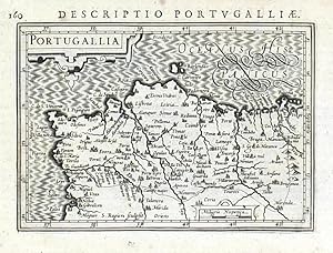
Portugallia
Verlag: Hondius, J., Amsterdam, 1616
Portugal. "Portugallia". Orig. copperplate engraving, P. Bertius. Published in Amsterdam by J. Hondius, 1616-18. With small ornamental cartouche and Latin title above the map. 9,3:13,2 cm (3 3/4 x 5 1/4 inch.). Koeman III, map 6300:342, ed. 342:01. - A west-oriented map of Portugal.
-

Guinea
Verlag: Visscher, Nicolaas Jansz., Amsterdam, 1649
Guinea. "Guinea". Orig. copperplate engraving. Published by C. J. Visscher in Amsterdam, 1649 (in Tabulae Geographicae Contrare). With ornamental title-cartouche and a sea-creature. 9:12,5 cm (3 1/2 x 5 inch.). Koeman III, map 8700:341, ed. 341:54 (1649 Tabulae, Visscher). - A miniature map of the northern coast of the Gulf of Guinea (Guinea, Sierra Leone, Liberia, Cote d'Ivoire, Ghana, Togo, Benin, Nigeria, Mali, Burkina).
