
Gesamtpreis (1 Artikel Artikel):
Versandziel:

berit lie (2 Ergebnisse)
Direkt zu den wichtigsten Suchergebnissen
Suchfilter
Produktart
- Alle Product Types
- B³cher (2)
- Magazine & Zeitschriften (Keine weiteren Ergebnisse entsprechen dieser Verfeinerung)
- Comics (Keine weiteren Ergebnisse entsprechen dieser Verfeinerung)
- Noten (Keine weiteren Ergebnisse entsprechen dieser Verfeinerung)
- Kunst, Grafik & Poster (Keine weiteren Ergebnisse entsprechen dieser Verfeinerung)
- Fotografien (Keine weiteren Ergebnisse entsprechen dieser Verfeinerung)
- Karten (Keine weiteren Ergebnisse entsprechen dieser Verfeinerung)
- Manuskripte & Papierantiquitõten (Keine weiteren Ergebnisse entsprechen dieser Verfeinerung)
Zustand Mehr dazu
- Neu (Keine weiteren Ergebnisse entsprechen dieser Verfeinerung)
- Wie Neu, Sehr Gut oder Gut Bis Sehr Gut (Keine weiteren Ergebnisse entsprechen dieser Verfeinerung)
- Gut oder Befriedigend (1)
- Ausreichend oder Schlecht (1)
- Wie beschrieben (Keine weiteren Ergebnisse entsprechen dieser Verfeinerung)
Einband
- alle Einbõnde
- Hardcover (Keine weiteren Ergebnisse entsprechen dieser Verfeinerung)
- Softcover (2)
Weitere Eigenschaften
- Erstausgabe (1)
- Signiert (Keine weiteren Ergebnisse entsprechen dieser Verfeinerung)
- Schutzumschlag (Keine weiteren Ergebnisse entsprechen dieser Verfeinerung)
- Angebotsfoto (Keine weiteren Ergebnisse entsprechen dieser Verfeinerung)
Sprache (1)
Preis
- Beliebiger Preis
- Weniger als EUR 20 (Keine weiteren Ergebnisse entsprechen dieser Verfeinerung)
- EUR 20 bis EUR 40
- Mehr als EUR 40
Gratisversand
Land des Verkõufers
Verkõuferbewertung
-
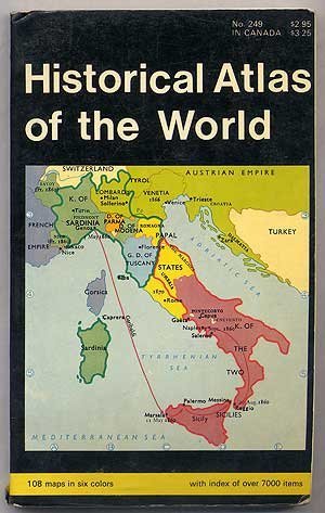
Historical Atlas of the World
Sprache: Englisch
Verlag: Barnes & Noble, Inc, New York, 1970
ISBN 10: 0389002534 ISBN 13: 9780389002536
Anbieter: Ground Zero Books, Ltd., Silver Spring, MD, USA
Verkõuferbewertung 4 von 5 Sternen

Erstausgabe
Trade paperback. Zustand: Good. Berit Lie (Maps) (illustrator). The format is approximately 4.875 inches by 7.75 inches. Unpaginated. 108 maps in six colors. Index with over 7000 items. Cover has some wear, creases, soiling, and chips. Front cover has some weakness. Clearly drawn, uncluttered maps present essentials at a glance. Dramatically shows the movement and progress of history. Contents covers Ancient Times (maps 1 to 31); The Middle Ages (maps 32 to 55); Recent times (Maps 56 to 93); and The Twentieth Century (Maps 94 to 108. Among the topics cartographically illustrated are: Greece during the Persian Wars; Greece during the Peloponnesian War, The Empire of Alexander the Great, the Punic Wars, The Barbarian Migrations and Kingdoms, Expansion of the Papal States, The Crusades, Renaissance Italy, Byzantine Empire, The Exploration of the New World, The Holy Roman Empire, Campaign of Charles XII, Brandenburg-Prussia, Europe in Napoleon's Time, Boer War, Western Front, Eastern Front, and Europe during the Second World War. A historical atlas is a collection of maps and possibly illustrations that depict the historical geography of a particular region at a defined time period. These atlases typically include maps that show the political and cultural boundaries of different states as well as other data, and in some cases illustrations that provide information about important historical events and figures. They may also include timelines, charts, and other information to help readers understand the historical context of the maps. Historical atlases are used by scholars, students, and general readers to study and learn about the past. Some try to present the entire history of the world, such as the Historical Atlas of the World, while others are more specialized, for only one time period or location, such as the Historical Atlas of the American West or The Historical Atlas of China. The first known historical atlas may have been the Parergon by Abraham Ortelius in 1579, which was a supplement to the Theatrum Orbis Terrarum. Presumed First paperback printing of this edition.
-

Historical atlas of the world
Sprache: Englisch
Verlag: Barnes & Noble (edition ), 1970
ISBN 10: 0389010871 ISBN 13: 9780389010876
Paperback. Zustand: Fair. The item might be beaten up but readable. May contain markings or highlighting, as well as stains, bent corners, or any other major defect, but the text is not obscured in any way.