Gesamtpreis (1 Artikel Artikel):
Versandziel:

bennett coleman ltd cartographer edward (1 Ergebnisse)
Direkt zu den wichtigsten Suchergebnissen
Produktart
- Alle Product Types
- Bücher
- Magazine & Zeitschriften
- Comics
- Noten
- Kunst, Grafik & Poster
- Fotografien
- Karten (1)
- Manuskripte & Papierantiquitäten
Zustand
- Alle
- Neu
- Antiquarisch (1)
Einband
- alle Einbände
- Hardcover
- Softcover
Weitere Eigenschaften
- Erstausgabe
- Signiert
- Schutzumschlag
- Angebotsfoto (1)
Gratisversand
- Versand nach USA gratis
Land des Verkäufers
Verkäuferbewertung
-
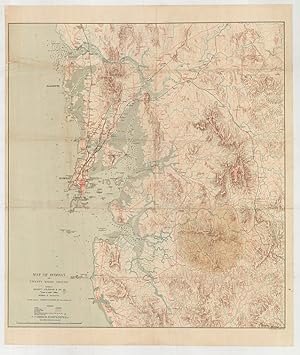
Map of Bombay and Twenty Miles Around.
Verlag: London: Edward Stanford's Geographical Establishment, []., 1911
Anbieter: Antiquariat Dasa Pahor GbR, München, Deutschland
Bewertung:

Karte
Colour lithograph, mounted upon original linen, folding, contemporary hand-stamp of 'King & Co. Booksellers, News Agents. Fort, Bombay' to verso linen (Good, save for conspicuous staining along vertical centrefold and in lower right quadrant, irregular creasing and wear along old folds), 79 x 67.5 cm (31 x 26.5 inches). Bombay (Mumbai), India: A rare, large format map depicting Greater Bombay just before World War I, when it was one of the busiest ports in the world and the 'Gateway of India', drafted by the office of the 'Times of India' and published in London by the venerable firm of Edward Stanford. This rare and detailed map depicts the Greater Bombay area as it appeared shortly before World War I, when it was one of the busiest ports in the world and the 'Gateway of India' (the idea for building the famous arch of that name on the city's waterfront was conceived the year that the map was made and completed in 1924). Bombay Island appears centre left, with the city occupying the southern portion. He map's scope extends north up to Bassein and past Thane and inland beyond the hill station of Matharan, and south along the coast past Alibag. Greater Bombay then had population of 1,108,388 according the 1911 census (today it has over 22 million inhabitants!). Bombay's great natural harbour is portrayed in full, with nautical information, with the elevations of the interior are expressed by shading. Then Bombay region was geographically dynamic, constantly altered by large-scale land reclamation schemes. Indeed, until the 1850s, Bombay Island consisted of seven islands until they were joined and filled in. Since the time when the present map was made, much more land reclamation has occurred around the harbour, while pretty much the entire region is today covered by urban sprawl, creating a very different picture than that portrayed here. Bombay, a great transport hub, is show with its several major labeled quays along its waterfront, while the extensive railway systems connect the city to all parts of India from the 'Victoria Terminus' (today's' Chhatrapati Shivaji Terminus, completed in 1888), one of the world's largest train stations. The map also shows the waterlines that connected the city to the lakes of Salsett Island. The map was drafted by the offices of the firm of Bennett, Coleman and Company Limited, that owned the Times of India, the subcontinent's most prestigious newspaper (est. 1838). It was printed in the London by Edward Stanford Ltd., for years by far and away the most important private map house in the world. A Note on Rarity - The present map is rare. We can locate 6 institutional examples, held by Johns Hopkins University Library; University of Washington; ZBW - Leibniz-Informationszentrum Wirtschaft (Kiel, Germany); University of Strathclyde Archives and Special Collections (Glasgow); Bharatiya Vidya Bhavan Library (Mumbai); and the Mumbai Archives. We are not aware of any examples as having appeared on the market. References: Johns Hopkins University Library: G7651.B6A1 s126 c. 1; University of Washington: G7654.B8 1910 E3; ZBW - Leibniz-Informationszentrum Wirtschaft: K 1037; University of Strathclyde Archives and Special Collections (Glasgow): GB 249 T-GED/22/1/1204; OCLC: 1038078771, 254925893; Bharatiya Vidya Bhavan Library (Mumbai): 912.547/TIM/10748; Bhaskar DHATAVKAR (ed.), Catlogue of Maps in the Bombay Archives, vol. II (Bombay, 1985), no. 2106 (p. 113); The Geographical Journal, vol. 38 (1910), p. 451.