Gesamtpreis (1 Artikel Artikel):
Versandziel:

beers frederick (52 Ergebnisse)
Direkt zu den wichtigsten Suchergebnissen
Suchfilter
Produktart
- Alle Product Types
- Bücher (47)
- Magazine & Zeitschriften (Keine weiteren Ergebnisse entsprechen dieser Verfeinerung)
- Comics (Keine weiteren Ergebnisse entsprechen dieser Verfeinerung)
- Noten (Keine weiteren Ergebnisse entsprechen dieser Verfeinerung)
- Kunst, Grafik & Poster (Keine weiteren Ergebnisse entsprechen dieser Verfeinerung)
- Fotografien (Keine weiteren Ergebnisse entsprechen dieser Verfeinerung)
- Karten (5)
- Manuskripte & Papierantiquitäten (Keine weiteren Ergebnisse entsprechen dieser Verfeinerung)
Zustand Mehr dazu
- Neu (14)
- Wie Neu, Sehr Gut oder Gut Bis Sehr Gut (2)
- Gut oder Befriedigend (10)
- Ausreichend oder Schlecht (Keine weiteren Ergebnisse entsprechen dieser Verfeinerung)
- Wie beschrieben (26)
Einband
Weitere Eigenschaften
- Erstausgabe (1)
- Signiert (Keine weiteren Ergebnisse entsprechen dieser Verfeinerung)
- Schutzumschlag (Keine weiteren Ergebnisse entsprechen dieser Verfeinerung)
- Angebotsfoto (35)
Sprache (2)
Gratisversand
Land des Verkäufers
Verkäuferbewertung
-
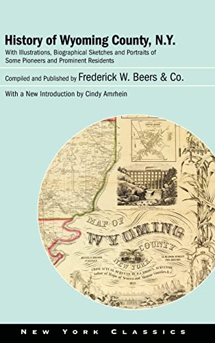
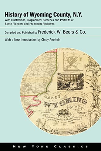
History of Wyoming County, N.Y.: With Illustrations, Biographical Sketches and Portraits of Some Pioneers and Prominent Residents (Excelsior Editions)
Sprache: Englisch
Verlag: Excelsior Editions/State Univers, 2022
ISBN 10: 1438487835 ISBN 13: 9781438487830
Anbieter: Books From California, Simi Valley, CA, USA
Verkäuferbewertung 4 von 5 Sternen

Hardcover. Zustand: Very Good. Cover and edges may have some wear.
-

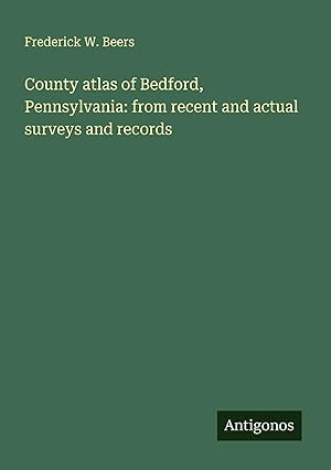
County atlas of Bedford, Pennsylvania
Anbieter: PBShop.store US, Wood Dale, IL, USA
Verkäuferbewertung 5 von 5 Sternen

PAP. Zustand: New. New Book. Shipped from UK. Established seller since 2000.
-
County atlas of Bedford, Pennsylvania
Anbieter: PBShop.store UK, Fairford, GLOS, Vereinigtes Königreich
Verkäuferbewertung 4 von 5 Sternen
EUR 26,23
EUR 3,80 Versand
Versand von Vereinigtes Königreich nach USAAnzahl: Mehr als 20 verfügbar
In den WarenkorbPAP. Zustand: New. New Book. Shipped from UK. Established seller since 2000.
-
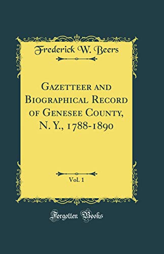
Gazetteer and Biographical Record of Genesee County, N. Y., 1788-1890, Vol. 1 (Classic Reprint)
Anbieter: WorldofBooks, Goring-By-Sea, WS, Vereinigtes Königreich
Verkäuferbewertung 5 von 5 Sternen
EUR 23,81
EUR 6,47 Versand
Versand von Vereinigtes Königreich nach USAAnzahl: 1 verfügbar
In den WarenkorbPaperback. Zustand: Very Good. The book has been read, but is in excellent condition. Pages are intact and not marred by notes or highlighting. The spine remains undamaged.
-
History of Wyoming County, N.Y.: With Illustrations, Biographical Sketches and Portraits of Some Pioneers and Prominent Residents (New York Classics)
Sprache: Englisch
Verlag: State University of New York Pre, 2023
ISBN 10: 1438487827 ISBN 13: 9781438487823
Anbieter: Books From California, Simi Valley, CA, USA
Verkäuferbewertung 4 von 5 Sternen
paperback. Zustand: Good.
-
History of Wyoming County, N.Y.: With Illustrations, Biographical Sketches and Portraits of Some Pioneers and Prominent Residents (New York Classics)
Sprache: Englisch
Verlag: State University of New York Pre, 2023
ISBN 10: 1438487827 ISBN 13: 9781438487823
Anbieter: Books From California, Simi Valley, CA, USA
Verkäuferbewertung 4 von 5 Sternen
paperback. Zustand: Very Good.
-

Gazetteer and Biographical Record of Genesee County, N. Y., 1788-1890, Vol. 1 (Classic Reprint)
Anbieter: PBShop.store US, Wood Dale, IL, USA
Verkäuferbewertung 5 von 5 Sternen
PAP. Zustand: New. New Book. Shipped from UK. Established seller since 2000.
-
Gazetteer and Biographical Record of Genesee County, N. Y., 1788-1890, Vol. 1 (Classic Reprint)
Anbieter: PBShop.store UK, Fairford, GLOS, Vereinigtes Königreich
Verkäuferbewertung 4 von 5 Sternen
EUR 33,51
EUR 8,82 Versand
Versand von Vereinigtes Königreich nach USAAnzahl: 15 verfügbar
In den WarenkorbPAP. Zustand: New. New Book. Shipped from UK. Established seller since 2000.
-
Gazetteer and Biographical Record of Genesee County, N Y, 17881890, Vol 1 Classic Reprint
Anbieter: PBShop.store UK, Fairford, GLOS, Vereinigtes Königreich
Verkäuferbewertung 4 von 5 Sternen
EUR 39,36
EUR 8,82 Versand
Versand von Vereinigtes Königreich nach USAAnzahl: 15 verfügbar
In den WarenkorbHRD. Zustand: New. New Book. Shipped from UK. Established seller since 2000.
-
History of Wyoming County, N.y.: With Illustrations, Biographical Sketches and Portraits of Some Pioneers and Prominent Residents
Anbieter: Revaluation Books, Exeter, Vereinigtes Königreich
Verkäuferbewertung 5 von 5 Sternen
EUR 53,25
EUR 17,33 Versand
Versand von Vereinigtes Königreich nach USAAnzahl: 2 verfügbar
In den WarenkorbPaperback. Zustand: Brand New. 906 pages. 9.00x6.00x1.00 inches. In Stock.
-
![Beispielbild für Gazetteer and biographical record of Genesee County, N.Y., 1788-1890 1890 [Hardcover] zum Verkauf von Majestic Books](https://pictures.abebooks.com/isbn/9789333372831-de-300.jpg)
Gazetteer and biographical record of Genesee County, N.Y., 1788-1890 1890 [Hardcover]
Anbieter: Majestic Books, Hounslow, Vereinigtes Königreich
Verkäuferbewertung 4 von 5 Sternen
EUR 66,04
EUR 7,51 Versand
Versand von Vereinigtes Königreich nach USAAnzahl: 4 verfügbar
In den WarenkorbZustand: New. pp. 920.
-

Atlas of Franklin and Grand Isle Counties, Vermont.
Sprache: Englisch
Verlag: Creative Media Partners, LLC Sep 2021, 2021
ISBN 10: 1014852641 ISBN 13: 9781014852649
Anbieter: AHA-BUCH GmbH, Einbeck, Deutschland
Verkäuferbewertung 5 von 5 Sternen
Taschenbuch. Zustand: Neu. Neuware.
-

Atlas of Windsor Co. Vermont / From Actual Surveys by and Under the Direction of F.W. Beers
Sprache: Englisch
Verlag: Creative Media Partners, LLC Sep 2021, 2021
ISBN 10: 1013757009 ISBN 13: 9781013757006
Anbieter: AHA-BUCH GmbH, Einbeck, Deutschland
Verkäuferbewertung 5 von 5 Sternen
Taschenbuch. Zustand: Neu. Neuware.
-

Atlas of Kalamazoo Co., Michigan
Sprache: Englisch
Verlag: Creative Media Partners, LLC Sep 2021, 2021
ISBN 10: 1014025877 ISBN 13: 9781014025876
Anbieter: AHA-BUCH GmbH, Einbeck, Deutschland
Verkäuferbewertung 5 von 5 Sternen
Taschenbuch. Zustand: Neu. Neuware.
-
Taschenbuch. Zustand: Neu. County atlas of Bedford, Pennsylvania: from recent and actual surveys and records | Frederick W. Beers | Taschenbuch | Englisch | 2024 | Antigonos Verlag | EAN 9783386121408 | Verantwortliche Person für die EU: preigu GmbH & Co. KG, Lengericher Landstr. 19, 49078 Osnabrück, mail[at]preigu[dot]de | Anbieter: preigu.
-

Atlas of Franklin and Grand Isle Counties, Vermont.
Sprache: Englisch
Verlag: Creative Media Partners, LLC Jul 2023, 2023
ISBN 10: 102052135X ISBN 13: 9781020521355
Anbieter: AHA-BUCH GmbH, Einbeck, Deutschland
Verkäuferbewertung 5 von 5 Sternen
Buch. Zustand: Neu. Neuware - Originally published in 1869, this atlas provides detailed maps of the counties of Franklin and Grand Isle in Vermont. Each map is accompanied by information about the area's geography, history, and demographics, making this a valuable resource for historians, genealogists, and anyone interested in the development of regional America. This new edition includes a comprehensive index, which makes it even more useful for researchers and scholars.
-

Gazetteer and Biographical Record of Genesee County, N. Y., 1788-1890, Vol. 1 (Classic Reprint)
Anbieter: AHA-BUCH GmbH, Einbeck, Deutschland
Verkäuferbewertung 5 von 5 Sternen
Taschenbuch. Zustand: Neu. Neuware.
-
Sonderangebot
EUR 14,73
EUR 105,00 Versand
Versand von Deutschland nach USAAnzahl: 3 verfügbar
In den WarenkorbZustand: Sehr gut. Zustand: Sehr gut | Seiten: 910 | Sprache: Englisch | Produktart: Bücher | Keine Beschreibung verfügbar.
-

Gazetteer and Biographical Record of Genesee County, N. Y., 1788-1890, Vol. 1 (Classic Reprint)
Anbieter: AHA-BUCH GmbH, Einbeck, Deutschland
Verkäuferbewertung 5 von 5 Sternen
Buch. Zustand: Neu. Neuware.
-
Sonderangebot
EUR 31,66
EUR 105,00 Versand
Versand von Deutschland nach USAAnzahl: 1 verfügbar
In den WarenkorbZustand: Sehr gut. Zustand: Sehr gut | Seiten: 908 | Sprache: Englisch | Produktart: Bücher | Keine Beschreibung verfügbar.
-
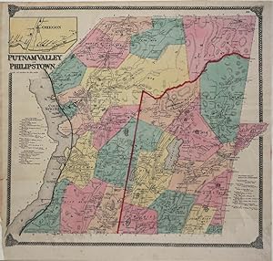
Putnam Valley and Philipstown. Map
Verlag: New York, 1867
Anbieter: Antipodean Books, Maps & Prints, ABAA, Garrison, NY, USA
Verbandsmitglied: ABAA ANZAAB ESA ILAB
Verkäuferbewertung 3 von 5 Sternen

Zustand: Very good condition. Map of Putnam County, NY, including Putnam Valley & Philipstown, including Cold Spring, Nelsonville, North Highlands, Garrison & Continental Village. Steel engraving with original wash color. Two contemporary folds, as usual. Includes names of property owners and roads, as well as 3 business directories for Philipstown, Garrison's and Putnam Valley in the margins, and an inset of 'Oregon' at the top left. One of the only early maps of Philipstown. From "Atlas of New York and vicinity from actual surveys." 19 x 20". Please note lines on right side of image are reflections off the protective mylar.
-

Atlas of Long Island, New York. From Recent and Actual Surveys and Records under the Supervision of F. W. Beers.
Verlag: Beers, Comstock & Cline, 1873
Anbieter: Arader Galleries - AraderNYC, New York, NY, USA
Verkäuferbewertung 5 von 5 Sternen
Hardcover. Zustand: Very Good. New York: Beers, Comstock & Cline, 1873. Folio (15 1/2" x 13", 400mm x 325mm). With folding and full-page hand-colored lithographed maps, including a large folding map of Long Island. 192 pp. Bound in quarter green leather over black pebbled leatherette. On the spine, title gilt to red leather label. Extremities rubbed. Chips to label on spine. Light toning and edgewear throughout. Some maps with refreshed mounts. The atlas is based on actual surveys under the direction of Federick William Beers (1839-1933) with pink, blue and yellow coloring. Beers was a prominent map publisher, cartographer and suveyor, the son of a map publisher, James Botsford Beers. After joining the family business in 1870, F. W. Beers is credited with mapping every county in New York State. Ownership manuscript on the front pastedown "E Merritt Weidner." From the collection of Esmond Bradley Martin (1941 2018; his sale, Doyle 7 November 2023, lot 68).
-
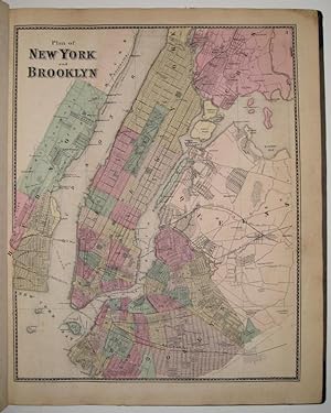
Atlas of New York and Vicinity
Verlag: F.W. Beers, A.D. Ellis & G.G. Soule, New York, 1867
Anbieter: Argosy Book Store, ABAA, ILAB, New York, NY, USA
Verkäuferbewertung 5 von 5 Sternen
hardcover. Zustand: very good. Atlas with 61 lithographed maps (11 of which fold out) and 5 views. Folio, measures 18" x 15". Original brown cloth binding with gold stamped title. Black leather spine and corners have been rebacked with black book cloth. Repair to title page, a few minor tears, scattered foxing throughout. Title page embossed at lower right by Landmarks Book Shop, Poughkeepsie; New York and Vicinity map has tear to left. Maps are complete, views are loose. A seminal 19th century New York atlas. Notable maps include New York and Vicinity, New York City and Brooklyn and various town plans from Westchester, Dutchess and Putnam counties. Frederick W. Beers (fl. 1858-1929), continued the work of his father James Botsford Beers and was known for his county survey maps of New York, Ohio, Pennsylvania, Michigan, Connecticut and Vermont.
-

First edition. Map of Highland Falls, West Point & Fort Montgomery in the Hudson Highlands area of the Hudson River. 12 1/2 x 15 1/4", lithograph with original hand color. Some local landmarks in Highland Falls include Cozzens Hotel, landowners including D. Parry, G. Bigelow, A. Mearns, Goodselli Bros, Meead & Taft & G & W. Ludlow, and other smaller holders. Fort Montgomery landowners includ S. Staat & T. Wilson. Wet Point lists Congreve & Ludlow as landowners on the grounds of West Point. District 3 includes Moore & Pintard, S.H. Townsend.
-
Far Rockaway; Town of Hempstead
Verlag: Beers, Comstock, & Cline, New York, 1873
Anbieter: Argosy Book Store, ABAA, ILAB, New York, NY, USA
Verkäuferbewertung 5 von 5 Sternen
unbound. Map. Lithograph with original hand coloring. Sheet measures 24" x 15". This 1873 map by Frederick W. Beers shows Far Rockaway from Central Avenue to the Atlantic Ocean. Railroads, streets, buildings, and features such as ice ponds and hills are marked with detail. Included in Beers' Atlas of Long Island, New York (1873). Verso shows Westville or North West Point with an inset of Little Neck. Map has some visible offsetting but otherwise in good condition. Frederick W. Beers (flourished 1858-1929) came from a family of surveyors, cartographers and publishers originally from Newtown Connecticut. F.W. Beers continued the work of his father James Botsford Beers and was known for his county survey maps of New York, Ohio, Pennsylvania, Michigan, Connecticut and Vermont.
-

Spencer and Oxford
Verlag: Beers, Comstock, & Cline, New York, 1870
Anbieter: Argosy Book Store, ABAA, ILAB, New York, NY, USA
Verkäuferbewertung 5 von 5 Sternen
unbound. Map. Engraving with original hand coloring. Image measures 14 1/4" x 22 1/2" This 1870 map by Frederick W. Beers shows the towns of Spencer and Oxford, Massachusetts. This map was published in Beers' Atlas of Worcester County, Massachusetts (1870). Includes business directories. Frederick W. Beers (flourished 1858-1929) came from a family of surveyors, cartographers and publishers originally from Newtown, Connecticut. F.W. Beers continued the work of his father James Botsford Beers and was known for his county survey maps of New York, Ohio, Pennsylvania, Michigan, Connecticut and Vermont.
-
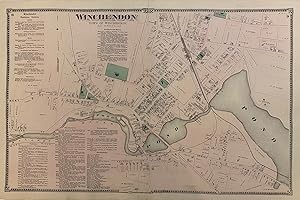
Winchendon
Verlag: Beers, Comstock, & Cline, New York, 1870
Anbieter: Argosy Book Store, ABAA, ILAB, New York, NY, USA
Verkäuferbewertung 5 von 5 Sternen
unbound. Map. Engraving with original hand coloring. Image measures 14 1/4" x 22 1/2" This 1870 map by Frederick W. Beers shows the town of Winchendon, Massachusetts. This map was published in Beers' Atlas of Worcester County, Massachusetts (1870). Includes a business directory. Frederick W. Beers (flourished 1858-1929) came from a family of surveyors, cartographers and publishers originally from Newtown, Connecticut. F.W. Beers continued the work of his father James Botsford Beers and was known for his county survey maps of New York, Ohio, Pennsylvania, Michigan, Connecticut and Vermont.
-
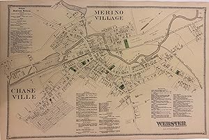
Webster
Verlag: Beers, Comstock, & Cline, New York, 1870
Anbieter: Argosy Book Store, ABAA, ILAB, New York, NY, USA
Verkäuferbewertung 5 von 5 Sternen
unbound. Map. Engraving with original hand coloring. Image measures 14 1/4" x 22 1/2" This 1870 map by Frederick W. Beers shows the town of Webster, Massachusetts. This map was published in Beers' Atlas of Worcester County, Massachusetts (1870). Shows Merino Village and Chase Ville. Includes a business directory. Frederick W. Beers (flourished 1858-1929) came from a family of surveyors, cartographers and publishers originally from Newtown, Connecticut. F.W. Beers continued the work of his father James Botsford Beers and was known for his county survey maps of New York, Ohio, Pennsylvania, Michigan, Connecticut and Vermont.
-
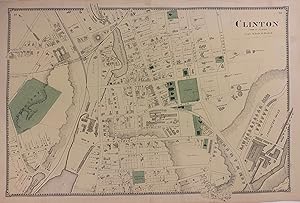
Clinton
Verlag: Beers, Comstock, & Cline, New York, 1870
Anbieter: Argosy Book Store, ABAA, ILAB, New York, NY, USA
Verkäuferbewertung 5 von 5 Sternen
unbound. Map. Engraving with original hand coloring. Image measures 14 1/4" x 22 1/2" This 1870 map by Frederick W. Beers shows the town of Clinton, Massachusetts. This map was published in Beers' Atlas of Worcester County, Massachusetts (1870). Frederick W. Beers (flourished 1858-1929) came from a family of surveyors, cartographers and publishers originally from Newtown, Connecticut. F.W. Beers continued the work of his father James Botsford Beers and was known for his county survey maps of New York, Ohio, Pennsylvania, Michigan, Connecticut and Vermont.
-
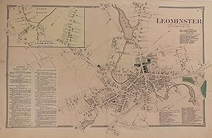
Leominster
Verlag: Beers, Comstock, & Cline, New York, 1870
Anbieter: Argosy Book Store, ABAA, ILAB, New York, NY, USA
Verkäuferbewertung 5 von 5 Sternen
unbound. Map. Engraving with original hand coloring. Image measures 14 1/4" x 22 1/2" This 1870 map by Frederick W. Beers shows the town of Leominster, Massachusetts. Includes a business directory, and an inset of the N.W. Section of Leominster (Morse Hollow). This map was published in Beers' Atlas of Worcester County, Massachusetts (1870). Frederick W. Beers (flourished 1858-1929) came from a family of surveyors, cartographers and publishers originally from Newtown, Connecticut. F.W. Beers continued the work of his father James Botsford Beers and was known for his county survey maps of New York, Ohio, Pennsylvania, Michigan, Connecticut and Vermont.