
Gesamtpreis (1 Artikel Artikel):
Versandziel:

bartholomew 1860 1920 (12 Ergebnisse)
Direkt zu den wichtigsten Suchergebnissen
Suchfilter
Produktart
- Alle Product Types
- Bücher (12)
- Magazine & Zeitschriften (Keine weiteren Ergebnisse entsprechen dieser Verfeinerung)
- Comics (Keine weiteren Ergebnisse entsprechen dieser Verfeinerung)
- Noten (Keine weiteren Ergebnisse entsprechen dieser Verfeinerung)
- Kunst, Grafik & Poster (Keine weiteren Ergebnisse entsprechen dieser Verfeinerung)
- Fotografien (Keine weiteren Ergebnisse entsprechen dieser Verfeinerung)
- Karten (Keine weiteren Ergebnisse entsprechen dieser Verfeinerung)
- Manuskripte & Papierantiquitäten (Keine weiteren Ergebnisse entsprechen dieser Verfeinerung)
Zustand Mehr dazu
- Neu (5)
- Wie Neu, Sehr Gut oder Gut Bis Sehr Gut (Keine weiteren Ergebnisse entsprechen dieser Verfeinerung)
- Gut oder Befriedigend (Keine weiteren Ergebnisse entsprechen dieser Verfeinerung)
- Ausreichend oder Schlecht (Keine weiteren Ergebnisse entsprechen dieser Verfeinerung)
- Wie beschrieben (7)
Einband
Weitere Eigenschaften
- Erstausgabe (4)
- Signiert (Keine weiteren Ergebnisse entsprechen dieser Verfeinerung)
- Schutzumschlag (1)
- Angebotsfoto (8)
Sprache (2)
Preis
- Beliebiger Preis
- Weniger als EUR 20 (Keine weiteren Ergebnisse entsprechen dieser Verfeinerung)
- EUR 20 bis EUR 45
- Mehr als EUR 45
Gratisversand
Land des Verkäufers
Verkäuferbewertung
-
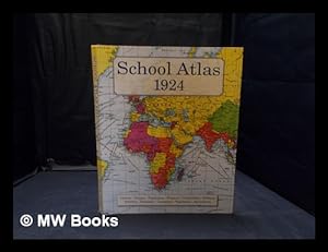
School atlas 1924 / by J.G. Bartholomew, with an introduction by L.W. Lyde
Verlag: Moretonhampstead, Devon: Old House Books, 2008
Old House Books Press Edition. Fine cloth copy in an equally fine dust wrapper. Particularly well-preserved overall; tight, bright, clean and especially sharp-cornered. Physical description: xii, 64 pages: chiefly colour maps, facsimiles 29 cm. Subjects: Atlases Economic aspects.Atlases Political aspects.Historical geography; MapsMaps Economic aspects. Maps; pictorial works. 3 Kg.
-

A Literary & Historical Atlas of Europe
Anbieter: Ria Christie Collections, Uxbridge, Vereinigtes Königreich
Verkäuferbewertung 5 von 5 Sternen

EUR 24,80
EUR 13,86 Versand
Versand von Vereinigtes Königreich nach USAAnzahl: Mehr als 20 verfügbar
In den WarenkorbZustand: New. In.
-

The Graphic Atlas and Gazetteer of the World
Anbieter: Ria Christie Collections, Uxbridge, Vereinigtes Königreich
Verkäuferbewertung 5 von 5 Sternen
EUR 28,01
EUR 13,86 Versand
Versand von Vereinigtes Königreich nach USAAnzahl: Mehr als 20 verfügbar
In den WarenkorbZustand: New. In.
-

A Literary & Historical Atlas of Europe
Anbieter: Ria Christie Collections, Uxbridge, Vereinigtes Königreich
Verkäuferbewertung 5 von 5 Sternen
EUR 34,41
EUR 13,86 Versand
Versand von Vereinigtes Königreich nach USAAnzahl: Mehr als 20 verfügbar
In den WarenkorbZustand: New. In.
-

The Graphic Atlas and Gazetteer of the World
Anbieter: Ria Christie Collections, Uxbridge, Vereinigtes Königreich
Verkäuferbewertung 5 von 5 Sternen
EUR 37,61
EUR 13,86 Versand
Versand von Vereinigtes Königreich nach USAAnzahl: Mehr als 20 verfügbar
In den WarenkorbZustand: New. In.
-

The international student's atlas of modern geography : a series of 105 physical, political, and statistical maps compiled from British and foreign surveys and the latest results of international research / under the direction of J.G. Bartholomew F.R.S.E., .F.R.G.S., etc.
Verlag: London : George Newnes, Limited
Erstausgabe
1st edition. Poor copy in the original stiff-card wrappers; edges somewhat dust-dulled and nicked. Spine worn, with tape to covers. Hinges starting. Foxing to prelims. Some pages loose. Maps remain clear and without blemish. Physical description; 175 pp. Subjects; Atlases Great Britain. World Educational. 3 Kg.
-

11th edition. Poor copy in the original title-blocked cloth. Spine bands worn; panel edges somewhat dust-toned and rubbed as with age. Boards stained. Text remains clear and without blemish. Physical description; 301 pp.,: 156 color maps ; 24 cm. Subjects; Roads England London ; Maps. London Maps, plans and views. Scales differ. 1 Kg.
-

A Literary and Historical Atlas of America
Sprache: Englisch
Verlag: Touchladybirdlucky Studios Sep 2015, 2015
ISBN 10: 134115159X ISBN 13: 9781341151590
Anbieter: AHA-BUCH GmbH, Einbeck, Deutschland
Verkäuferbewertung 5 von 5 Sternen
Buch. Zustand: Neu. Neuware - This work has been selected by scholars as being culturally important, and is part of the knowledge base of civilization as we know it. This work was reproduced from the original artifact, and remains as true to the original work as possible. Therefore, you will see the original copyright references, library stamps (as most of these works have been housed in our most important libraries around the world), and other notations in the work. This work is in the public domain in the United States of America, and possibly other nations. Within the United States, you may freely copy and distribute this work, as no entity (individual or corporate) has a copyright on the body of the work.As a reproduction of a historical artifact, this work may contain missing or blurred pages, poor pictures, errant marks, etc. Scholars believe, and we concur, that this work is important enough to be preserved, reproduced, and made generally available to the public. We appreciate your support of the preservation process, and thank you for being an important part of keeping this knowledge alive and relevant.
-

The international reference atlas of the world
Verlag: London : George Newnes Ltd., 1914
Erstausgabe
First Edition. Pen inscribed by previous owner. Good copy in the original title-blocked cloth. Spine bands and panel edges somewhat bumped and rubbed as with age. Some foxing to spine cover. Scattered foxing internally. Remains quite well-preserved overall. Physical description: xvi, 120 p. col.maps.70 p ; 36 cm. Notes: Includes index.Includes index. Contents: A new series of 121 modern maps with introductory text, geographical pronunciation and general index of places. Subjects: Atlases Great Britain. Atlases, British. 3 Kg.
-
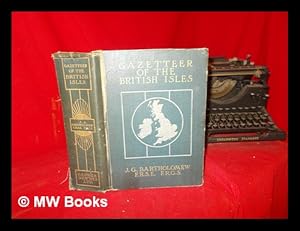
The survey gazetteer of the British Isles, topographical, statistical, and commercial : compiled from the 1901 census and the latest official returns / Ed. by J.G. Barthololmew . With appendices and special maps
Verlag: London : George Newnes, Limited, 1904
Erstausgabe
First Edition. Poor copy in the original gilt decorated pictorial cloth; wear and tear as with age. Front board starting., with the title page detached, but loosely inserted. Text remains in fine condition and without blemish. Physical description; [8], 928 pages : illustrations, 64 (i.e. 55) colour plates (including maps, plans, diagrams, charts); 27 cm. Subjects; Gazetteers. Great Britain ; Gazetteers. Ireland ; Gazetteers. Great Britain. Ireland. Genres; cartographic image. Gazetteers. Illustrated 4 Kg.
-

The Penetration of Arabia : a record of the development of Western knowledge concerning the Arabian peninsula / by David George Hogarth ; with illustrations from drawings, photographs and maps ; and maps by J. G. Bartholomew
Verlag: London: Alston Rivers, Limited, 1905
Erstausgabe
First Edition. Poor copy in the original gilt decorated cloth; wear and tear as with age. Front board starting. Text remains in fine condition and without blemish. Physical description; xv, 359 p : ill., plates, ports., maps (2 fold.), plans, facsims ; 23 cm. Notes; Bibliography at end of each chapter. Contents; Before exploration -- Niebuhr in Yemen -- Pilgrims in Hijaz -- The Egyptians in Nejd -- The Egyptians in the southwest -- The unknown south -- The unknown north -- Western borderlands -- Southern borderlands -- Eastern borderlands -- The central north -- The centre -- The central south -- Anknown Arabia -- Summary. Subjects; Arabian Peninsula - Description and travel. Europeans Arabian peninsula. Orientalism History. Travelers Arabian Peninsula. Orientalists. Arabian Peninsula Discovery and exploration. Arabian Peninsula Description and travel. Arabian Peninsula History. Arabian Peninsula Discovery and exploration. Arabian Peninsula Geography. Arabian Peninsula ; Maps. Arabian Peninsula History Sources. 3 Kg.
-
The XXth Century Citizen's Atlas of the World. Containing 156 pages of maps and plans with an index, a gazetteer, and geographical statistics. Edited by J.G. Bartholomew, F.R.G.S.
Verlag: George Newnes, [1902]., London:, 1902
Anbieter: Jeff Weber Rare Books, Neuchatel, NEUCH, Schweiz
Verkäuferbewertung 4 von 5 Sternen

Folio. xvi, 133, [1] pp. 156 ff. with fine color folding maps, each neatly tabbed in order to allow even/flat opening of each map. The map 'plates' are printed on the rectos only. Index. Original half maroon leather, maroon decorative cloth, simple spine rules and title in gilt; joints cracked (but holding), extremities & corners showing. Good +. PROVENANCE: P. Patton Milne, 12/12/1902; William Hutton Stewart, 2nd May, 1960. With the color folding maps in excellent condition. "Under his administration the family business became one of the top operations in its field. Bartholomew himself was not merely a specialist in production, but also a talented geographer and cartographer. It was he who introduced the use of coloured contour layer maps developed by his father . . ." The maps are here all printed in colors and the maps are all well researched and presented for this purpose. J.G. Bartholomew was a founding member of the R.S.G.S. As a holder of a royal warrant, he used the title "Cartographer to the King"; for this reason, he was sometimes known by the epithet "the Prince of Cartography". / "Bartholomew gave much thought to the perfecting of the technical processes of map-production as well as to the planning of new geographical works; and by keeping in touch with the latest progress of discovery and research he avoided the tendency of some map-makers to content themselves with following in the footsteps of their predecessors. The two great atlases of Scotland and of England and Wales, published in 1895 (second edition 1912) and 1903 respectively, are among the most important of his works, embodying an immense amount of geographical and statistical research . . . Bartholomew's work as a map-maker is distinguished both by accuracy in detail and by skill in craftsmanship; but his most important contribution to the science of cartography was his extension and improvement of the system of layer colouring for marking contours, a system by which his maps attain a high degree of delicacy and effectiveness. His skilful use of colour for other purposes, as for instance in population maps, is also noteworthy." â" DNB. PROVENANCE [2]: [1] P. Patton Milne, 12/12/1902; [2] William Hutton Stewart, 2nd May, 1960.
