Gesamtpreis (1 Artikel Artikel):
Versandziel:

back captain george (8 Ergebnisse)
Direkt zu den wichtigsten Suchergebnissen
Suchfilter
Produktart
- Alle Product Types
- Bücher (8)
- Magazine & Zeitschriften (Keine weiteren Ergebnisse entsprechen dieser Verfeinerung)
- Comics (Keine weiteren Ergebnisse entsprechen dieser Verfeinerung)
- Noten (Keine weiteren Ergebnisse entsprechen dieser Verfeinerung)
- Kunst, Grafik & Poster (Keine weiteren Ergebnisse entsprechen dieser Verfeinerung)
- Fotografien (Keine weiteren Ergebnisse entsprechen dieser Verfeinerung)
- Karten (Keine weiteren Ergebnisse entsprechen dieser Verfeinerung)
- Manuskripte & Papierantiquitäten (Keine weiteren Ergebnisse entsprechen dieser Verfeinerung)
Zustand Mehr dazu
- Neu (Keine weiteren Ergebnisse entsprechen dieser Verfeinerung)
- Wie Neu, Sehr Gut oder Gut Bis Sehr Gut (Keine weiteren Ergebnisse entsprechen dieser Verfeinerung)
- Gut oder Befriedigend (5)
- Ausreichend oder Schlecht (2)
- Wie beschrieben (1)
Einband
- alle Einbände
- Hardcover (6)
- Softcover (Keine weiteren Ergebnisse entsprechen dieser Verfeinerung)
Weitere Eigenschaften
- Erstausgabe (5)
- Signiert (Keine weiteren Ergebnisse entsprechen dieser Verfeinerung)
- Schutzumschlag (1)
- Angebotsfoto (4)
Sprache (1)
Preis
- Beliebiger Preis
- Weniger als EUR 20 (Keine weiteren Ergebnisse entsprechen dieser Verfeinerung)
- EUR 20 bis EUR 45 (Keine weiteren Ergebnisse entsprechen dieser Verfeinerung)
- Mehr als EUR 45
Gratisversand
Land des Verkäufers
Verkäuferbewertung
-
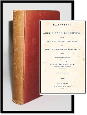
Narrative of the Arctic Land Expedition to the Mouth of the Great Fish River, and Along the Shores of the Arctic Ocean, in the Years 1833, 1834 and 1835. Illustrated By a Map
Verlag: E. L. Carey and A. Hart, Philadelphia, 1837
Anbieter: Resource Books, LLC, East Granby, CT, USA
Verbandsmitglied: SNEAB
Verkäuferbewertung 5 von 5 Sternen

Hardcover. Zustand: Fair. Philadelphia: E. L. Carey and A. Hart, 1837. Stated second edition, 1837, this edition published without the plates included in the 1836 edition. Journal of an expedition in Canada from Great Slave Lake, Northwest Territories, northeast to the Fish River and the Arctic Coast, illustrated with a folding frontis map. Worn ex-library copy in tan hardcover with tan cloth spine, paper spine label, page edges untrimmed, 456 pages, two pages of publisher ads and a list of testimonials at front. Covers heavily worn and chipped, paper spine label darkened but legible with a chip to the bottom corner, internally better with good hinges, sound text block, pages clean with fairly uniform light to moderate foxing throughout, map lightly foxed and without chips or tears. Library blindstamp on title page, bookplate inside front cover, no other internal library markings. . Hard Cover. Fair. 8vo - over 7ľ" - 9ľ" tall.
-

Narrative of The Arctic Land Expedition, to the Mouth of The Great Fish River, and along the shores of The Arctic Ocean, in the years 1833, 1834, and 1835
Verlag: Charles E. Tuttle, Rutland, VT, 1970
Anbieter: Lorne Bair Rare Books, ABAA, Winchester, VA, USA
Verbandsmitglied: ABAA ILAB IOBA
Verkäuferbewertung 5 von 5 Sternen
Zustand des Schutzumschlags: dj. First Thus. Octavo. 19.5cm. Publisher's dark blue cloth titled in gilt and black to spine. Dustjacket. [xxv]; 663pp. Strong and bright, very light wear to extremities; internally clean and fresh, illustrated throughout; in a strong, clean dustjacket with some light marginal creasing. A very good copy indeed. A facsimile edition of the 1836 first edition, faithfully and rather attractively reproduced by the Tuttle Co. who seem to have had extensive interests publishing books in Japan. An accessible account of Back's dramatic exploratory voyages.
-

Narrative of the Arctic Land Expedition to the Mouth of the Great Fish River and Along the Shores of the Arctic Ocean in the Years 1833, 1834, 1835
Verlag: E.L. Carey & A. Hart, Philadelphia, 1836
Anbieter: RareNonFiction, IOBA, Ladysmith, BC, Kanada
Verbandsmitglied: IOBA
Verkäuferbewertung 5 von 5 Sternen
Erstausgabe
Hardcover. Zustand: Fair. First American Edition. 456 pages. Fold-out map present at title page. Foxing throughout. Binding open at title page. Bit of pencil writing to front endpaper. Back hinge open. Above-average wear and soiling.
-

Narrative Of The Arctic Land Expedition To The Mouth Of The Great Fish River, And Along The Shores Of The Arctic Ocean, In The Years 1833, 1834, And 1835.
Verlag: London: John Murray, 1836., 1836
Anbieter: D & E LAKE LTD. (ABAC/ILAB), Toronto, ON, Kanada
Verkäuferbewertung 2 von 5 Sternen

Erstausgabe
Hardcover. Zustand: Very Good. 1st Edition. 4to. pp. x, [1 leaf]list of plates, 663, [1]. large folding engraved map & 16 engraved & lithographed plates on india paper, mounted. 8 wood-engraved text illus. (incl. map). modern bds. (very occasional light foxing, some offsetting from plates). First Edition: Large-Paper Admiralty Issue. Back had previously gained considerable experience as an arctic explorer through his participation in the abortive Buchan expedition and Franklin's two overland expeditions. Back was "one of the first competent artists to penetrate into the Canadian Arctic"; the many watercolours and drawings which he produced and which enhance his narratives and those of Franklin "are now considered an invaluable record of early northern history" (DCB). Although Back was highly valued by the British Admiralty, he was not a popular personality and he developed a fairly controversial reputation as a dandy, womanizer and hopeless egocentric. The privately financed, government-assisted expedition described in this narrative was undertaken in 1833, for the purpose of aiding members of the Second Ross expedition, from whom no one had heard since 1828. They were also to conduct scientific investigations and a geographical survey of an unknown section of arctic coast. They travelled overland from Montreal to Slave River and Great Slave Lake, and descended the Thleweechodozeth or Great Fish River (later renamed the Back River) to the arctic coast, thence along Chantrey Inlet to Ogle Point. The work also includes a valuable appendix on natural history and scientific subjects by Back, Richardson, Hooker, Children, Fitton and King, a discussion of Hearne's journey, 1769-72, by Richardson (chapt. 5), observations on the Netsilik Esquimaux at the mouth of the Back River, &c. A list of subscribers to the expedition occupies pp. 638-63. Arctic Bib. 851. Field 63 (17 plates). Lande 935. Sabin 2613. cfSmith 393. cfTPL 1873. DCB X pp. 26-29. Story p. 44.
-
Narrative Of The Arctic Land Expedition To The Mouth Of The Great Fish River, And Along The Shores Of The Arctic Ocean, In The Years 1833, 1834, And 1835.
Verlag: London: John Murray, 1836., 1836
Anbieter: D & E LAKE LTD. (ABAC/ILAB), Toronto, ON, Kanada
Verkäuferbewertung 2 von 5 Sternen
Erstausgabe
Hardcover. Zustand: Very Good. 1st Edition. 8vo. pp. x, [1 leaf]list of plates, 663, [1]. large folding engraved map & 16 engraved & lithographed plates. 8 wood-engraved text illus. (incl. map). untrimmed in full modern calf by Annegret Hunter-Elsenbach, spine richly gilt (map neatly backed on rice paper, some leaves with light marginal dampstains). First Edition. Back had previously gained considerable experience as an arctic explorer through his participation in the abortive Buchan expedition and Franklin's two overland expeditions. Back was "one of the first competent artists to penetrate into the Canadian Arctic"; the many watercolours and drawings which he produced and which enhance his narratives and those of Franklin "are now considered an invaluable record of early northern history" (DCB). Although Back was highly valued by the British Admiralty, he was not a popular personality and he developed a fairly controversial reputation as a dandy, womanizer and hopeless egocentric. The privately financed, government-assisted expedition described in this narrative was undertaken in 1833, for the purpose of aiding members of the Second Ross expedition, from whom no one had heard since 1828. They were also to conduct scientific investigations and a geographical survey of an unknown section of arctic coast. They travelled overland from Montreal to Slave River and Great Slave Lake, and descended the Thleweechodozeth or Great Fish River (later renamed the Back River) to the arctic coast, thence along Chantrey Inlet to Ogle Point. The work also includes a valuable appendix on natural history and scientific subjects by Back, Richardson, Hooker, Children, Fitton and King, a discussion of Hearne's journey, 1769-72, by Richardson (chapt. 5), observations on the Netsilik Esquimaux at the mouth of the Back River, &c. A list of subscribers to the expedition occupies pp. 638-63. Arctic Bib. 851. Sabin 2613. Smith 393. TPL 1873. cfField 63 (17 plates). cfLande 935. DCB X pp. 26-29. Story p. 44.
-
Narrative Of The Arctic Land Expedition To The Mouth Of The Great Fish River, And Along The Shores Of The Arctic Ocean, In The Years 1833, 1834, And 1835.
Verlag: London: John Murray, 1836., 1836
Anbieter: D & E LAKE LTD. (ABAC/ILAB), Toronto, ON, Kanada
Verkäuferbewertung 2 von 5 Sternen
Erstausgabe
Hardcover. Zustand: Very Good. 1st Edition. 8vo. pp. x, [1 leaf]list of plates, 663, [1]. large folding engraved map & 16 engraved & lithographed plates. 8 wood-engraved text illus. (incl. map). original blind-stamped cloth (joints repaired, pp. 109-112 misbound after p. 100). First Edition. Back had previously gained considerable experience as an arctic explorer through his participation in the abortive Buchan expedition and Franklin's two overland expeditions. Back was "one of the first competent artists to penetrate into the Canadian Arctic"; the many watercolours and drawings which he produced and which enhance his narratives and those of Franklin "are now considered an invaluable record of early northern history" (DCB). Although Back was highly valued by the British Admiralty, he was not a popular personality and he developed a fairly controversial reputation as a dandy, womanizer and hopeless egocentric. The privately financed, government-assisted expedition described in this narrative was undertaken in 1833, for the purpose of aiding members of the Second Ross expedition, from whom no one had heard since 1828. They were also to conduct scientific investigations and a geographical survey of an unknown section of arctic coast. They travelled overland from Montreal to Slave River and Great Slave Lake, and descended the Thleweechodozeth or Great Fish River (later renamed the Back River) to the arctic coast, thence along Chantrey Inlet to Ogle Point. The work also includes a valuable appendix on natural history and scientific subjects by Back, Richardson, Hooker, Children, Fitton and King, a discussion of Hearne's journey, 1769-72, by Richardson (chapt. 5), observations on the Netsilik Esquimaux at the mouth of the Back River, &c. A list of subscribers to the expedition occupies pp. 638-63. Field 63 (17 plates). Lande 935. Sabin 2613n. cfArctic Bib. 851. cfSmith 393. cfTPL 1873. DCB X pp. 26-29. Story p. 44.
-
Narrative of the Arctic Land Expedition to the Mouth of the Great Fish River, and Along the Shores of the Arctic Ocean, in the Years 1833, 1834, and 1835
Verlag: John Murray, London, 1836
Anbieter: Argosy Book Store, ABAA, ILAB, New York, NY, USA
Verkäuferbewertung 5 von 5 Sternen
hardcover. Zustand: very good. Illustrated with a large folding map, 16 engraved plates, some text illustrations. x, [2], 663pp., thick 8vo, 3/4 brown calf; (rubbed, corners bumped, light foxing on some pages and plate margins, full page inscription by previous owner on flyleaf). London: John Murray, 1836. Very good. A fine source for both the early exploration of the far North as well as ethnology, includes details about Back's commerce with the Cree, Chippewa, and Coppermine Indians, and information relating to Arctic flora and fauna. Streeter Sale 3704. Sabin 2613. Wagner-Camp 58b.
-
Narrative of the Arctic Land Expedition to the Mouth of the Great Fish River, and along the Shores of the Arctic Ocean in the Years 1833, 1834, and 1835
Verlag: E.L. Carey & A. Hart, Philadelphia, 1836
Anbieter: Blind-Horse-Books (ABAA), DeLand, FL, USA
Verbandsmitglied: ABAA ESA FABA ILAB IOBA
Verkäuferbewertung 5 von 5 Sternen
Erstausgabe
Zustand: Very Good. Zustand des Schutzumschlags: No Dust Jacket. Red cloth, spine lettered in gilt. 9.5 inches tall; 456 pp. Without the four page publisher's ads at the front. Illustrated with folding frontispiece map. First U.S. Edition. Ex-library (Bowdoin College, withdrawn bookplate), and pencil marks on the rear paste-down are the only markings. Moderate wear to cloth, spine sunned; foxing, repairs to map; Clean text with occasional margin spotting. The First American edition of Back's overland expedition narrative from Montreal to the central Arctic, aimed at aiding the second Ross expedition members, received acclaim from Field as a crucial resourceequivalent to Franklin's workfor comprehending the indigenous peoples of the North. During its publication, "The Quarterly Review" lauded its literary style as surpassing any prior accounts on the subject. Notably, the edition's map is a smaller segment derived from the original map featured in the first London edition released in the same year. Back covered over 7500 miles, 1200 of which were previously unknown territory. His narrative holds literary esteem and is "full of details about the Cree, Chippewa, Coppermine Indians, and other tribes, upon whom members of the exhibition were obliged to depend during a terrible winter" [Hill] Back was commissioned to complete the survey of the coast between Prince Regent's Inlet and Turnagain Point but the Terror was beset by ice for nearly a year (August 1837- July 1837), drifting in the pack off northeast Southampton Island. Ref: Field 65; Sabin 2613; Wagner-Camp 58b:3. First Edition, First Printing. [American].