
Gesamtpreis (1 Artikel Artikel):
Versandziel:

arrowsmith john stanford edward (3 Ergebnisse)
Feedback
Direkt zu den wichtigsten Suchergebnissen
Suchfilter
Produktart
- Alle Product Types
- Bücher (Keine weiteren Ergebnisse entsprechen dieser Verfeinerung)
- Magazine & Zeitschriften (Keine weiteren Ergebnisse entsprechen dieser Verfeinerung)
- Comics (Keine weiteren Ergebnisse entsprechen dieser Verfeinerung)
- Noten (Keine weiteren Ergebnisse entsprechen dieser Verfeinerung)
- Kunst, Grafik & Poster (Keine weiteren Ergebnisse entsprechen dieser Verfeinerung)
- Fotografien (Keine weiteren Ergebnisse entsprechen dieser Verfeinerung)
- Karten (3)
- Manuskripte & Papierantiquitäten (Keine weiteren Ergebnisse entsprechen dieser Verfeinerung)
Zustand
- Alle
- Neu (Keine weiteren Ergebnisse entsprechen dieser Verfeinerung)
- Antiquarisch (3)
Einband
- alle Einbände
- Hardcover (2)
- Softcover (Keine weiteren Ergebnisse entsprechen dieser Verfeinerung)
Weitere Eigenschaften
- Erstausgabe (Keine weiteren Ergebnisse entsprechen dieser Verfeinerung)
- Signiert (Keine weiteren Ergebnisse entsprechen dieser Verfeinerung)
- Schutzumschlag (Keine weiteren Ergebnisse entsprechen dieser Verfeinerung)
- Angebotsfoto (3)
Sprache (1)
Preis
- Beliebiger Preis
- Weniger als EUR 20 (Keine weiteren Ergebnisse entsprechen dieser Verfeinerung)
- EUR 20 bis EUR 45 (Keine weiteren Ergebnisse entsprechen dieser Verfeinerung)
- Mehr als EUR 45
Gratisversand
- Kostenloser Versand nach Deutschland (Keine weiteren Ergebnisse entsprechen dieser Verfeinerung)
Land des Verkäufers
Verkäuferbewertung
-

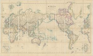
A Chart of the World on Mercator's Projection Shewing the principal Ocean Steam Routes, the Submarine Telegraphs &c.
Verlag: LondonEdward Stanford 55 Charing Cross Jan. 1st ., 1885
Anbieter: Robert Frew Ltd. ABA ILAB, London, Vereinigtes Königreich
Verbandsmitglied: ABA ILAB PBFA
Verkäuferbewertung 4 von 5 Sternen

Karte
EUR 1.161,08
Währung umrechnenEUR 7,71 für den Versand von Vereinigtes Königreich nach DeutschlandAnzahl: 1 verfügbar
In den WarenkorbOriginal engraved map of the world (69.5 x 103.5 cm) with outline colour, dissected into 40 panels and laid onto linen, two panels with marbled endpapers, folding into original brown cloth slipcase with publisher's yellow title label to upper portion. The map recording steam routes including travel times and underwater telegraph cables; map inserts of the Arctic and Antarctica (polar projection) in lower right and lower left quadrants. Generally an excellent, well preserved copy. Edward Stanford, Fellow of the Royal Geographical Society, acquired the plates and stock of John Arrowsmith in 1874.
-
A Chart of the World on Mercator's Projection Shewing the principal Ocean Steam Routes, the Submarine Telegraphs &c.
Verlag: LondonEdward Stanford 55 Charing Cross June 1st ., 1881
Anbieter: Robert Frew Ltd. ABA ILAB, London, Vereinigtes Königreich
Verbandsmitglied: ABA ILAB PBFA
Verkäuferbewertung 4 von 5 Sternen
Karte
EUR 1.527,73
Währung umrechnenEUR 7,71 für den Versand von Vereinigtes Königreich nach DeutschlandAnzahl: 1 verfügbar
In den WarenkorbOriginal engraved map of the world (69.5 x 103.5 cm) with outline colour, dissected into 40 panels and laid onto linen, two panels with marbled endpapers, folding into original brown cloth slipcase with publisher's yellow title label to upper portion. The map recording steam routes including travel times and underwater telegraph cables; map inserts of the Arctic and Antarctica (polar projection) in lower right and lower left quadrants. Some occasional light soiling, generally an excellent example. Edward Stanford, Fellow of the Royal Geographical Society, acquired the plates and stock of John Arrowsmith in 1874.
-

Map of the Countries round the North Pole.
Verlag: Edward Stanford, 55 Charing Cross,, London,, 1875
Anbieter: Daniel Crouch Rare Books Ltd, London, Vereinigtes Königreich
Verbandsmitglied: ABA ILAB PBFA
Verkäuferbewertung 4 von 5 Sternen
Karte
EUR 1.222,18
Währung umrechnenEUR 17,80 für den Versand von Vereinigtes Königreich nach DeutschlandAnzahl: 1 verfügbar
In den WarenkorbStanford's map of the Arctic Lithograph and coloured, dissected and mounted on linen, folding into original blue cloth slipcase, publisher's label pasted on, yellow advertisement for "Standford's Series of New Library Maps" at endpaper of cover and map when folded. The present map of the Arctic regions was first issued in 1818 by Aaron Arrowsmith, most likely in response to William Parry's discoveries in the region. Aaron Arrowsmith's son John would continue to update and reissue the map up until 1859 - no later editions are recorded, most probably due to the fact that in 1861 Arrowsmith went into semi-retirement. Following Arrowsmith's death, in 1874, Edward Stanford acquired the plate and continued to issue the map until the 1930s. The present example dates from 1875, and represents the earliest issue of the map under Stanford's name. The map depicts all the voyages of discovery in the Arctic, from John Cabot's (1497), and Hudson (1607), to the Austro-Hungarian voyage of Weyprecht and Payer (1872-1874). All the voyages are marked with a name and date in red, although the only track highlighted is that of John Franklin. Other additions made by Stanford include the marking of the full extent of the polar ice sheet, and pack ice, together with a dotted line denoting the "Southern limit of Drift Ice or Icebergs". Edward Stanford (1827-1904) was a well known British mapmaker, publisher and Fellow of the Royal Geographical Society. As a result of his involvement in the Society as well as the India Office he gained a reputation as a publisher of explorers. After starting his own business Stanford became known for his "library maps", particularly those of Africa and Asia. Aside of launching his own maps, he enlargened his stock by buying plates of other publishers. In 1874 he did, for example, acquire the plates and stock of John Arrowsmith, heir of the Arrowsmith family firm. After his death in 1904 the business was continued by his son Edward Jr. Verner & Stubbs, The Northpart of America, p.162.