Gesamtpreis (1 Artikel Artikel):
Versandziel:

aprčs mannevillette jean baptiste (42 Ergebnisse)
Direkt zu den wichtigsten Suchergebnissen
Suchfilter
Produktart
- Alle Product Types
- Bücher (29)
- Magazine & Zeitschriften (Keine weiteren Ergebnisse entsprechen dieser Verfeinerung)
- Comics (Keine weiteren Ergebnisse entsprechen dieser Verfeinerung)
- Noten (Keine weiteren Ergebnisse entsprechen dieser Verfeinerung)
- Kunst, Grafik & Poster (Keine weiteren Ergebnisse entsprechen dieser Verfeinerung)
- Fotografien (Keine weiteren Ergebnisse entsprechen dieser Verfeinerung)
- Karten (13)
- Manuskripte & Papierantiquitäten (Keine weiteren Ergebnisse entsprechen dieser Verfeinerung)
Zustand Mehr dazu
- Neu (8)
- Wie Neu, Sehr Gut oder Gut Bis Sehr Gut (1)
- Gut oder Befriedigend (3)
- Ausreichend oder Schlecht (Keine weiteren Ergebnisse entsprechen dieser Verfeinerung)
- Wie beschrieben (30)
Einband
Weitere Eigenschaften
- Erstausgabe (7)
- Signiert (Keine weiteren Ergebnisse entsprechen dieser Verfeinerung)
- Schutzumschlag (Keine weiteren Ergebnisse entsprechen dieser Verfeinerung)
- Angebotsfoto (42)
Sprache (3)
Gratisversand
- Kostenloser Versand nach USA (Keine weiteren Ergebnisse entsprechen dieser Verfeinerung)
Land des Verkäufers
Verkäuferbewertung
-

EUR 20,17
EUR 48,99 für den Versand von Deutschland nach USAAnzahl: Mehr als 20 verfügbar
In den WarenkorbZustand: New.
-

EUR 21,35
EUR 48,99 für den Versand von Deutschland nach USAAnzahl: Mehr als 20 verfügbar
In den WarenkorbZustand: New.
-

Mémoire Sur La Navigation de France Aux Indes
Verlag: Hachette Livre - BNF Mai 2013, 2013
ISBN 10: 2012856586 ISBN 13: 9782012856585
Sprache: Französisch
Anbieter: AHA-BUCH GmbH, Einbeck, Deutschland
Verkäuferbewertung 5 von 5 Sternen

Taschenbuch. Zustand: Neu. Neuware.
-

EUR 42,07
EUR 48,99 für den Versand von Deutschland nach USAAnzahl: Mehr als 20 verfügbar
In den WarenkorbZustand: New.
-

Taschenbuch. Zustand: Neu. Mémoire Sur La Navigation de France Aux Indes | Jean-Baptiste-Nicolas-Denis D' Aprčs de Mannevillette | Taschenbuch | Kartoniert / Broschiert | Französisch | 2013 | Hachette Livre - BNF | EAN 9782012856585 | Verantwortliche Person für die EU: Libri GmbH, Europaallee 1, 36244 Bad Hersfeld, gpsr[at]libri[dot]de | Anbieter: preigu.
-
Taschenbuch. Zustand: Neu. Le Nouveau Quartier Anglais, Ou Description Et Usage d'Un Nouvel Instrument Pour Observer | La Latitude Sur Mer | Jean-Baptiste-Nicolas-Denis D' Aprčs de Mannevillette | Taschenbuch | Kartoniert / Broschiert | Französisch | 2016 | Hachette Livre - BNF | EAN 9782019541798 | Verantwortliche Person für die EU: Libri GmbH, Europaallee 1, 36244 Bad Hersfeld, gpsr[at]libri[dot]de | Anbieter: preigu.
-

Instructions Sur La Navigation Des Indes Orientales Et de la Chine, Pour Servir Au Neptune Oriental : Dédié Au Roi
Verlag: Hachette Livre - BNF Mai 2013, 2013
ISBN 10: 2012856578 ISBN 13: 9782012856578
Sprache: Französisch
Anbieter: AHA-BUCH GmbH, Einbeck, Deutschland
Verkäuferbewertung 5 von 5 Sternen
Taschenbuch. Zustand: Neu. Neuware.
-

Taschenbuch. Zustand: Neu. Instructions Sur La Navigation Des Indes Orientales Et de la Chine, Pour Servir Au Neptune Oriental | , Dédié Au Roi | Jean-Baptiste-Nicolas-Denis D' Aprčs de Mannevillette | Taschenbuch | Kartoniert / Broschiert | Französisch | 2013 | Hachette Livre - BNF | EAN 9782012856578 | Verantwortliche Person für die EU: Libri GmbH, Europaallee 1, 36244 Bad Hersfeld, gpsr[at]libri[dot]de | Anbieter: preigu.
-
Supplément au Neptune oriental
Verlag: A Brest, chez Malassis, libraire et imprimeur de la Marine, A Paris, Chez Demonville, imprimeur libraire de l'académie Françoise, rue Christine, 1781
Anbieter: Abraxas-libris, Bécherel, Frankreich
Verbandsmitglied: ILAB
Verkäuferbewertung 5 von 5 Sternen
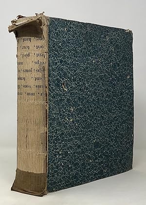
Relié. In-8 (20 x 25,3 cm), reliure demi-vélin ŕ coins, couverture muette, xx + 52 pages, supplément posthume au "Neptune Oriental" de l'hydrographe Jean-Baptiste-Nicolas-Denis d'Aprčs de Mannevillette, comprenant des additions et corrections ŕ l'ouvrage ainsi qu'une biographie de l'auteur ; usure aux coupes, traces sur les plats, intérieur trčs frais, bel exemplaire. Livraison a domicile (La Poste) ou en Mondial Relay sur simple demande.
-
Routier des côtes des Indes Orientales et de la Chine.
Verlag: Paris, Ch. J. B. Delespine, 1745., 1745
Anbieter: Antiquariat INLIBRIS Gilhofer Nfg. GmbH, Vienna, A, Österreich
Verbandsmitglied: ILAB PADA VDA VDAO
Verkäuferbewertung 5 von 5 Sternen
Large 4to (203 x 260 mm). (6), LVIII, 254, (2) pp. Title-page printed in red and black. With an engraved headpiece. Contemporary full calf, spine rebacked and gilt to style. Leading edges gilt, all edges sprinkled in red. Marbled endpapers. Extremely rare pilot guide to the East Indies, reduced to a single quarto volume from the author's great "Neptune Oriental", published simultaneously. One of the greatest maritime atlases in the history of French cartography, the "Neptune" was devoted to exotic regions (the Middle East including the Gulf, the African coasts, the Indian Ocean and East Indies, Southeast Asia, parts of the Chinese coast, and the Pacific islands). It was compiled by Jean-Baptiste-Nicolas-Denis d'Aprčs de Mannevillette (1707-80), hydrographer to the French Navy, supported by the French East India Company and the Académie des Sciences. "It was at once hailed as a major achievement and welcomed by navigators throughout the world" (Cat. Nat. Mar. Mus.). Of the present text-only reduction, OCLC lists no more than nine copies worldwide, only one of which in the the U.S. (University of Chicago). - Corners bumped; modern spine gilt in 18th-century style. A good, wide-margined copy. Provenance: 1) From the library of Sir Francis Lindley Wood, 2nd Baronet, of Barnsley (1771-1846), with his bookplate on the pastedown. 2) By descent to his son Charles Wood, 1st Viscount Halifax (1800-85), sometime Chancellor of the Exchequer, with handwritten ownership on the flyleaf. As President of the Board of Control of the English East India Company, Sir Charles Wood was instrumental in spreading education in India. 3) Acquired from the Portuguese trade. - Jöcher/Adelung II, 622. OCLC 41102601. Not in Cordier (Sinica), Brunet, Graesse, etc.
-
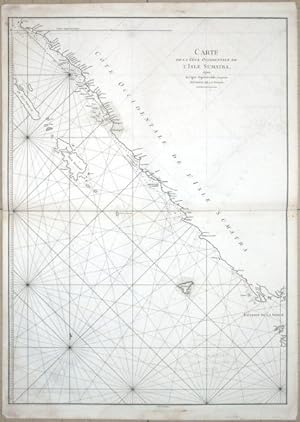
Carte Plate de la Côte Occidentale de l'Isle Sumatra
Verlag: Apres de Mannevillette, Jean Baptiste d', Paris, 1780
Anbieter: Antikvariat Krenek, Prag, Tschechien
Verbandsmitglied: ILAB
Verkäuferbewertung 5 von 5 Sternen
Sumatra (Indonesia)."Carte Plate de la Cote Occidentale de l'Isle Sumatra". J. B. d'Apres de Mannevillette, from his "Neptune orientale". Orig. copperplate engraving, engraved by G. de la Haye. Published in Paris, ca. 1780. With title in upper left corner. 48,5:66,5 cm (19 x 26 1/4 inch.). Sea chart of the central part of the western coast of Sumatra. Oriented to the east.
-

Carte Plate de la Côte Occidentale de l'Isle Sumatra
Verlag: Apres de Mannevillette, Jean Baptiste d', Paris, 1780
Anbieter: Antikvariat Krenek, Prag, Tschechien
Verbandsmitglied: ILAB
Verkäuferbewertung 5 von 5 Sternen
"Carte Plate de la Cote Occidentale de l'Isle Sumatra". J. B. d'Apres de Mannevillette, from his "Neptune orientale". Orig. copperplate engraving, engraved by G. de la Haye. Published in Paris, ca. 1780. With title in upper left corner. 48,5:66,5 cm (19 x 26 1/4 inch.). Sea chart of the central part of the western coast of Sumatra. Oriented to the east.
-

Verhandeling over de zeevaart van Frankryk naar de Indiën. Uit het Fransch Vertaald door P. Steenstra.
Verlag: Amsterdam, Johannes van Keulen en Zoonen,, 1769
Sprache: Deutsch
Anbieter: Antiquariat J. Hünteler, Hamburg, Deutschland
Verbandsmitglied: GIAQ
Verkäuferbewertung 5 von 5 Sternen
EUR 2.500,00
EUR 45,00 für den Versand von Deutschland nach USAAnzahl: 1 verfügbar
In den WarenkorbZustand: Gut. X, 85 S. Mit 3 Holzschnitt-Vignetten. Jean-Baptiste Nicolas Denis d`Aprčs de Mannevillette (1707 - 1780), französischer Kartograph u. Hydrograph. Er kartografierte die Küsten Indiens und Chinas. - Einband an den Kanten und am Rücken etwas berieben, Reste von Papierschildchen auf Rücken, Seiten leicht gebräunt, gelöschter Bibliotheksstempel und winzige hs. Ziffer auf Titelblatt, sonst gutes Exemplar. P116442_Seefahrt_S: SBH Sprache: Deutsch Gewicht in Gramm: 1100 8°, HLn. d. Z. mit rot. Ldr.-Rückenschild, goldgepr. Rückentitel sowie Rückengoldfileten, marmor. Deckel.
-
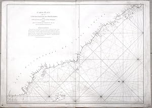
Carte de La Cote Occidentale de l'Isle Sumatra
Verlag: Apres de Mannevillette, Jean Baptiste d', Paris, 1780
Anbieter: Antikvariat Krenek, Prag, Tschechien
Verbandsmitglied: ILAB
Verkäuferbewertung 5 von 5 Sternen
Sumatra (Indonesia)."Carte de La Cote Occidentale de l'Isle Sumatra depuis . Detroit de la Sonde". J. B. d'Apres de Mannevillette, from his "Neptune orientale". Orig. copperplate engraving, engraved by G. de la Haye. Published in Paris, ca. 1780. With title in upper right corner. 67:49 cm. Sea chart of the part of the south-western coast of Sumatra with the Nassau (Nias) and Fortune isles.
-

Carte de La Cote Occidentale de l'Isle Sumatra
Verlag: Apres de Mannevillette, Jean Baptiste d', Paris, 1780
Anbieter: Antikvariat Krenek, Prag, Tschechien
Verbandsmitglied: ILAB
Verkäuferbewertung 5 von 5 Sternen
"Carte de La Cote Occidentale de l'Isle Sumatra depuis . Detroit de la Sonde". J. B. d'Apres de Mannevillette, from his "Neptune orientale". Orig. copperplate engraving, engraved by G. de la Haye. Published in Paris, ca. 1780. With title in upper right corner. 67:49 cm. Sea chart of the part of the south-western coast of Sumatra with the Nassau (Nias) and Fortune isles.
-

Carte du Detroit de la Sonde ou de Batavia au Detroit de Banca
Verlag: Apres de Mannevillette, Jean Baptiste d', Paris, 1780
Anbieter: Antikvariat Krenek, Prag, Tschechien
Verbandsmitglied: ILAB
Verkäuferbewertung 5 von 5 Sternen
"Carte pour aller du Detroit de la Sonde ou de Batavia au Detroit de Banca". J. B. d'Apres de Mannevillette, from his atlas "Neptune orientale". Orig. copperplate engraving, published in Paris, ca. 1780. With title upper left corner and small inset map of the small isles nearby the south-eastern coast of Sumatra ("Plan des Isles Remouw, Kandagang, High et Voody, situes au Sud-Est de l'Isle Sumatra", 22,5:13,5 cm). 67:49 cm (26 1/4 x 19 1/4 inch.). Sea chart of the south-eastern coast of Sumatra.
-
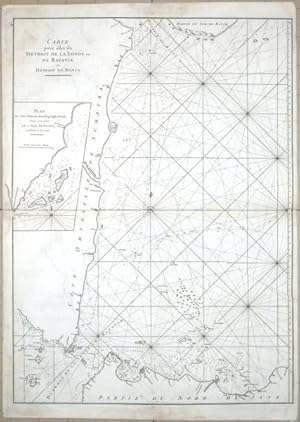
Carte du Detroit de la Sonde ou de Batavia au Detroit de Banca
Verlag: Apres de Mannevillette, Jean Baptiste d', Paris, 1780
Anbieter: Antikvariat Krenek, Prag, Tschechien
Verbandsmitglied: ILAB
Verkäuferbewertung 5 von 5 Sternen
Sumatra (Indonesia)."Carte pour aller du Detroit de la Sonde ou de Batavia au Detroit de Banca". J. B. d'Apres de Mannevillette, from his atlas "Neptune orientale". Orig. copperplate engraving, published in Paris, ca. 1780. With title upper left corner and small inset map of the small isles nearby the south-eastern coast of Sumatra ("Plan des Isles Remouw, Kandagang, High et Voody, situes au Sud-Est de l'Isle Sumatra", 22,5:13,5 cm). 67:49 cm (26 1/4 x 19 1/4 inch.). Sea chart of the south-eastern coast of Sumatra.
-
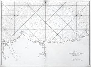
Carte de la Cote d'Afrique
Verlag: Apres de Mannevillette, Jean Baptiste d', Paris, 1780
Anbieter: Antikvariat Krenek, Prag, Tschechien
Verbandsmitglied: ILAB
Verkäuferbewertung 5 von 5 Sternen
Gambia, Senegal and Mauritania."Carte de la Cote d'Afrique, depuis le Cap Blanc jusques et Compris la Rivere de Gambie". J. B. d'Apres de Mannevillette, from his atlas "Neptune orientale". Orig. copperplate engraving, published in Paris, ca. 1780. With title in lower right corner. 48,5:67,5 cm (19 1/4 x 26 1/2 inch.). Sea chart of the eastern cost of North Africa.
-
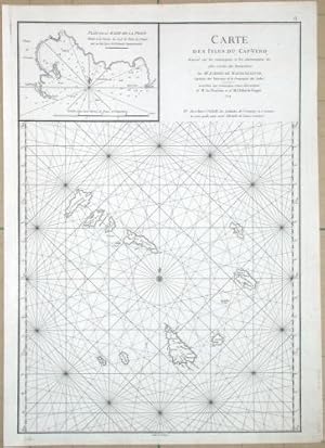
Carte des Isles du Cap-Verd
Verlag: Apres de Mannevillette, Paris, 1774
Anbieter: Antikvariat Krenek, Prag, Tschechien
Verbandsmitglied: ILAB
Verkäuferbewertung 5 von 5 Sternen
Karte
Kein Einband. Zustand: Gut bis sehr gut. Cape Verde Islands. "Carte des Isles du Cap-Verd". Orig. copperplate engraving from J. B. d'Apres de Mannevillette, "Neptune orientale", Paris, 1774. Engraved by G.-N. Delahaye. With title in upper right corner and inset map of "Plan de la Rade de la Praye" (11:16 cm). 48:33,5 cm (19 x 13 1/4 inch.). A sea chart of the Cape Verde islands.
-

Carte des Isles du Cap-Verd
Verlag: Apres de Mannevillette, Jean Baptiste d', Paris, 1774
Anbieter: Antikvariat Krenek, Prag, Tschechien
Verbandsmitglied: ILAB
Verkäuferbewertung 5 von 5 Sternen
Cape Verde Islands."Carte des Isles du Cap-Verd". J. B. d'Apres de Mannevillette, from his "Neptune orientale". Orig. copperplate engraving, engraved by G. de la Haye. Published in Paris, 1774. With title in upper right corner and inset map of "Plan de la Rade de la Praye" (11:16 cm). 48:33,5 cm (19 x 13 1/4 inch.). Sea chart of Cape Verde islands.
-

Nouveau Plan des Detroits de Java et de Madura les Detroits de Bali
Verlag: Apres de Mannevillette, Jean Baptiste d', Paris, 1780
Anbieter: Antikvariat Krenek, Prag, Tschechien
Verbandsmitglied: ILAB
Verkäuferbewertung 5 von 5 Sternen
"Nouveau Plan des Detroits . de Java et de Madura . les Detroits de Bali". J. B. d'Apres de Mannevillette, from his "Neptune orientale". Orig. copperplate engraving by G. de la Haye. Published in Paris, ca. 1780. With title and explanatory notes in upper right corner and small inset map ("Plan de la Baye de Ballambougang", 10,5:10 cm). 49:34 cm. Sea chart of the Straits between Java and Bali.
-

Nouveau Plan des Detroits de Java et de Madura les Detroits de Bali
Verlag: Apres de Mannevillette, Jean Baptiste d', Paris, 1780
Anbieter: Antikvariat Krenek, Prag, Tschechien
Verbandsmitglied: ILAB
Verkäuferbewertung 5 von 5 Sternen
Bali."Nouveau Plan des Detroits . de Java et de Madura . les Detroits de Bali". J. B. d'Apres de Mannevillette, from his "Neptune orientale". Orig. copperplate engraving by G. de la Haye. Published in Paris, ca. 1780. With title and explanatory notes in upper right corner and small inset map ("Plan de la Baye de Ballambougang", 10,5:10 cm). 49:34 cm. Sea chart of the Straits between Java and Bali.
-

Plan de Salangor et de la Cote de Malaye
Verlag: Apres de Mannevillette, Jean Baptiste d', Paris, 1780
Anbieter: Antikvariat Krenek, Prag, Tschechien
Verbandsmitglied: ILAB
Verkäuferbewertung 5 von 5 Sternen
"Plan de Salangor et de la Cote de Malaye". J. B. d'Apres de Mannevillette, from his "Neptune orientale". Orig. copperplate engraving, engraved by G. de la Haye. Published in Paris, ca. 1780. With title in upper right corner and engraved pofile of the coast. 48,5:33 cm. Sea chart of the part of Malaysian coast.
-
![Bild des Verkäufers für [Arabian Gulf]. Carte du Golfe Persique, depuis Bassora jusqu'au Cap Rasalgate. zum Verkauf von Robert Frew Ltd. ABA ILAB](https://pictures.abebooks.com/inventory/md/md32068743960.jpg)
[Arabian Gulf]. Carte du Golfe Persique, depuis Bassora jusqu'au Cap Rasalgate.
Verlag: Paris & BrestDemonville ., 1775
Anbieter: Robert Frew Ltd. ABA ILAB, London, Vereinigtes Königreich
Verbandsmitglied: ABA ILAB PBFA
Verkäuferbewertung 4 von 5 Sternen

Karte
EUR 1.458,66
EUR 11,33 für den Versand von Vereinigtes Königreich nach USAAnzahl: 1 verfügbar
In den WarenkorbOriginal double-page map (48 x 66 cm, overall sheet 55 x 70 cm) with inset "Plan des Isles Karak et Korgo et de la Baye de Bundereek" engraved on copper by Guillaume-Nicolas Delahaye. Some light marginal toning, generally a very good copy of this elegant map of the Gulf, the most accurate of its day. This fine, rare nautical map of the Arabian Gulf forms part of the famous "Neptune Oriental", a highly regarded collection of maps of the Middle and Far Eastern coasts which the author, the French hydrographer d'Aprčs de Mannevillette (1707-1780), had mapped during his time as captain for the French East India Company. The collection was first published in 1745, but redrawn and newly engraved by Guillaume-Nicolas Delahaye for the 1775 edition. The chart (plate 28 in the volume) is stated to be based on information collected by captain René Julien Le Floch de La Carriere and in many respects resembles the roughly contemporaneous works of William Herbert (Al Ankary no. 190) and d'Anville (Al Ankary no. 211). About the present map (in its 1745 version), Zoltán Biedermann writes, "It is interesting to note that, despite the fact that the shape of the Gulf is rooted in the Dutch tradition that we have come to name after Cornelis Roobacker, there are many new place names that were not there in the earlier decades. Like some other items from this period, this map is thus a precious document of the shifting commercial geography of Persia and the Persian Gulf" (Historical Atlas of the Persian Gulf, p. 290). The map includes an early reference to Qatar. The town labelled Deh-Rogn on an island near the coast of Bahrain transliterates to "the village at Ras Rakan," referring to a geographical feature of a small spit at the northernmost point of the peninsula. Interestingly, an island labelled Samaca lies to the east, so Qatar and Bahrain may have been interchanged on this map. The area to the south of Qatar is described as "little frequented, thus little known." Other geographical details are overlooked, especially in the south of the map near the present day United Arab Emirates. The pearl banks of the southern gulf are yet to become famous and remain unmarked. Some inaccuracies are recorded in the map, such as Daba [Dubai] being placed on the Omani coast. (Tibbetts no. 265; not in Al Ankary but cf. nos. 208f. for two other maps by Mannevillette - the Gulf of Aden and the port of Jeddah - hailed as "extremely accurate" and supplying "detailed information").
-
![Bild des Verkäufers für [Manila]. Plan De La Baye et Ville de Manille, Capitale des Isles Philippines, Située en L'Isle Luçon, par 14. D.gré 39.m de Latitude Septentrionale, & par 118 D.gré 33.m de Longitude Méridien de l'Observatoire de Paris. zum Verkauf von Robert Frew Ltd. ABA ILAB](https://pictures.abebooks.com/inventory/md/md31910516617.jpg)
[Manila]. Plan De La Baye et Ville de Manille, Capitale des Isles Philippines, Située en L'Isle Luçon, par 14. D.gré 39.m de Latitude Septentrionale, & par 118 D.gré 33.m de Longitude Méridien de l'Observatoire de Paris.
Verlag: Paris ., 1775
Anbieter: Robert Frew Ltd. ABA ILAB, London, Vereinigtes Königreich
Verbandsmitglied: ABA ILAB PBFA
Verkäuferbewertung 4 von 5 Sternen
Karte Erstausgabe
EUR 1.458,66
EUR 11,33 für den Versand von Vereinigtes Königreich nach USAAnzahl: 1 verfügbar
In den WarenkorbOriginal copper-engraved sea chart of Manilla (57.5 x 41.5 cm overall) printed on heavy paper. The chart extends from the North coast of Mindoro Island to north of Pointe de Capones, centered on Manilla Bay and Subec Bay. It is based on the most progressive sources available to the French Navy. European interest in Manila Bay, and the Philippines in general, was heightened upon hearing news of British Admiral George Anson's capture of a Spanish Manila Galleon off of Cabo Espiritu Santo, in 1743. A few isolated spots, generally a very good clean copy. The present chart was drafted by French sailor and hydrographer Jean-Batiste de Mannevillette (1707-80). Mannevillette apprenticed under the great royal cartographer Guillaume De L'Isle. He then joined the maritime service of the Compagnie des Indes, eventually attaining the rank of captain. Upon his return to Paris, Mannevillette was appointed as director of the Dépôt des Cartes et Plans de la Navigation des Indes. In 1745, he published the first edition of his sea atlas of Asian waters, Le Neptune Oriental, regarded as a major achievement and a library indispensable to navigators. The high quality of Mannevillette's charts won him the acclaim of both mariners and academics alike, and he was admitted as a fellow of the Academy of Sciences. He published a second, heavily revised, edition of the Neptune Oriental in 1775., from which the present chart derives.
-
INSTRUCTIONS SUR LA NAVIGATION DES INDES ORIENTALES ET DE LA CHINE, POUR SERVIR AU NEPTUNE ORIENTAL
Verlag: Edition : PARIS, CHEZ DEZAUCHE, 1775, 1775
Anbieter: Livres 113, BEAUTIRAN, Frankreich
Verkäuferbewertung 5 von 5 Sternen
Suivi de SUPPLEMENT AU NEPTUNE ORIENTAL (1781) - Reliure in 4, plein cuir, dos lisse orné - Reliure défectueuse, mais restant solide, coins frottés, coiffes arrachées - Intérieur frais (4), lviii,574, (14), xv, xx, 52 pages, 26 cm, relié. Etat moyen.
-
A Chart of the Red Sea from Geddah to Suez, According to the General Chart of Mr. d'Apres de Mannevillette, Corrected and Improved From the Surveys Made by Mr. C. Niebuhr in 1762 and 1763.
Verlag: London, Robert Sayer & John Bennett, 1781., 1781
Anbieter: Antiquariat INLIBRIS Gilhofer Nfg. GmbH, Vienna, A, Österreich
Verbandsmitglied: ILAB PADA VDA VDAO
Verkäuferbewertung 5 von 5 Sternen
Engraved map. 60 x 84 cm. Constant ratio linear horizontal scale ca. 1:1,500,000. With insert maps: "A Plan of the Harbour of Suez" and "A Plan of the Harbour of Tor". Rare map covering the Red Sea from Jeddah in the south to the Gulf of Suez in the north. Published as part of Robert Sayer's "Complete East-India pilot or Oriental Navigator" (1778ff., subsequently reissued by Laurie & Whittle), it is based on D'Aprčs de Mannevillette's "Neptune Oriental" (1745), incorporating information gleaned from the 1762-63 surveys of Carsten Niebuhr. - A few professionally repaired edge tears. - OCLC 733624449.
-
Instructions sur la Navigation des Indes Orientales et de la China, pour servir au Neptune Oriental, dedie au Roi.
Verlag: 1775-1781., 1775
Anbieter: Maggs Bros. Ltd ABA, ILAB, PBFA, London, Vereinigtes Königreich
Verbandsmitglied: ABA ILAB PBFA
Verkäuferbewertung 5 von 5 Sternen
Erstausgabe
EUR 1.166,93
EUR 30,59 für den Versand von Vereinigtes Königreich nach USAAnzahl: 1 verfügbar
In den WarenkorbFirst Edition. Small quarto (255 x 210 mm), two parts in one volume; [4], lviii, 574, [xiv], xv, [1]; xx, 52pp. Modern binding, incorporating the upper board. Minor dampstaining to the Supplément; the instructions to the binder annotated in pencil. Paris : Dezauche & Demonville; Brest : Malassis, This is the text volume of sailing instructions compiled by Aprčs de Mannevillette (1707-1780) for the French East India Company. Born in Le Havre to a seafaring family Apres de Mannevillette had a long and distinguished career as a navigator and was one of the first French hydrographers. After studying mathematics in Paris, he gained early experience of the sea in a voyage to the Caribbean at the age of nineteen. During many subsequent voyages he assembled a collection of material for his East Indian hydrographic atlas called 'Neptune Oriental' which was published in 1745 with the support of the Academie des Sciences. In 1762 he was promoted to director of the depository of all the reports, charts and plans relating to the navigation of the vessels of the Company in the Orient, and over the succeeding years several expanded editions of this atlas were issued. A second edition of the 'Instructions' was posthumously published in 1811. The second part is the Supplément, issued in 1781, which includes a biography of the author.
-
Instructions sur la Navigation des Indes Orientales et de la China, pour servir au Neptune Oriental, dedie au Roi.
Verlag: 1775-1781., 1775
Anbieter: Maggs Bros. Ltd ABA, ILAB, PBFA, London, Vereinigtes Königreich
Verbandsmitglied: ABA ILAB PBFA
Verkäuferbewertung 5 von 5 Sternen
Erstausgabe
EUR 1.750,39
EUR 30,59 für den Versand von Vereinigtes Königreich nach USAAnzahl: 1 verfügbar
In den WarenkorbFirst Edition. Small quarto (247 x 187 mm), two parts in one volume; [4], lviii, 574, [xiv], xv, [1]; xx, 52pp. Contemporary calf, worn, erased ownership inscription on title, stamp on front endpaper "Conselheiro Mendoca Cortez". Minor dampstaining to the Supplément. 574; Paris : Dezauche & Demonville; Brest : Malassis, This is the text volume of sailing instructions compiled by Aprčs de Mannevillette (1707-1780) for the French East India Company. Born in Le Havre to a seafaring family Apres de Mannevillette had a long and distinguished career as a navigator and was one of the first French hydrographers. After studying mathematics in Paris, he gained early experience of the sea in a voyage to the Caribbean at the age of nineteen. During many subsequent voyages he assembled a collection of material for his East Indian hydrographic atlas called 'Neptune Oriental' which was published in 1745 with the support of the Academie des Sciences. In 1762 he was promoted to director of the depository of all the reports, charts and plans relating to the navigation of the vessels of the Company in the Orient, and over the succeeding years several expanded editions of this atlas were issued. A second edition of the 'Instructions' was posthumously published in 1811. The second part is the Supplément, issued in 1781, which includes a biography of the author.
-
Routier des cotes des Indes Orientales et de la Chine.
Erscheinungsdatum: 1745
Anbieter: Maggs Bros. Ltd ABA, ILAB, PBFA, London, Vereinigtes Königreich
Verbandsmitglied: ABA ILAB PBFA
Verkäuferbewertung 5 von 5 Sternen
EUR 2.917,32
EUR 30,59 für den Versand von Vereinigtes Königreich nach USAAnzahl: 1 verfügbar
In den WarenkorbOne engraved coastal view. Title-page printed in red and black. Previous old ownership inscription clipped and repaired. 4to. Contemporary full calf, spine gilt in compartments. scattered staining, minor repairs to binding, joints slightly cracked. [vi], LVIII, 254, [ii]pp. Paris, Ch. J. B. Delespine, Rare Pilot to the East Indies published simultaneously to accompany the large "Neptune Oriental" atlas. It was compiled by Jean-Baptiste-Nicolas-Denis d'Aprčs de Mannevillette (1707-80), hydrographer to the French Navy, supported by the French East India Company and the Académie des Sciences. Born in Le Havre of a seafaring family Apres de Mannevillette had a long and distinguished career as a navigator and was one of the first French hydrographers. After studying mathematics in Paris, he gained early experience of the sea in a voyage to the Caribbean at the age of nineteen. During many subsequent voyages he assembled a collection of material for this East Indian hydrographic atlas which was published with the support of the Academie des Sciences.