Gesamtpreis (1 Artikel Artikel):
Versandziel:

andriveau j (31 Ergebnisse)
Direkt zu den wichtigsten Suchergebnissen
Suchfilter
Produktart
- Alle Product Types
- BŘcher (20)
- Magazine & Zeitschriften (Keine weiteren Ergebnisse entsprechen dieser Verfeinerung)
- Comics (Keine weiteren Ergebnisse entsprechen dieser Verfeinerung)
- Noten (Keine weiteren Ergebnisse entsprechen dieser Verfeinerung)
- Kunst, Grafik & Poster (1)
- Fotografien (Keine weiteren Ergebnisse entsprechen dieser Verfeinerung)
- Karten (10)
- Manuskripte & Papierantiquitńten (Keine weiteren Ergebnisse entsprechen dieser Verfeinerung)
Zustand Mehr dazu
- Neu (Keine weiteren Ergebnisse entsprechen dieser Verfeinerung)
- Wie Neu, Sehr Gut oder Gut Bis Sehr Gut (6)
- Gut oder Befriedigend (10)
- Ausreichend oder Schlecht (Keine weiteren Ergebnisse entsprechen dieser Verfeinerung)
- Wie beschrieben (15)
Einband
Weitere Eigenschaften
- Erstausgabe (3)
- Signiert (Keine weiteren Ergebnisse entsprechen dieser Verfeinerung)
- Schutzumschlag (Keine weiteren Ergebnisse entsprechen dieser Verfeinerung)
- Angebotsfoto (23)
Sprache (3)
Gratisversand
- Kostenloser Versand nach USA (Keine weiteren Ergebnisse entsprechen dieser Verfeinerung)
Land des Verkńufers
Verkńuferbewertung
-
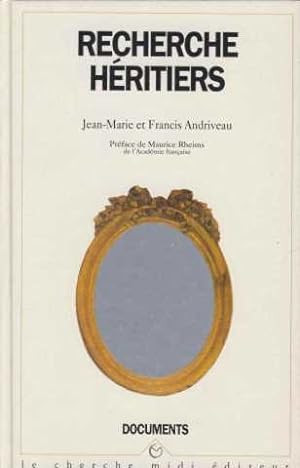
Recherche hÚritiers
Sprache: Franz÷sisch
Verlag: Cherche midi / Documents, 1994
ISBN 10: 2862743488 ISBN 13: 9782862743486
Anbieter: DÚmons & Merveilles, Joinville, Frankreich
Verkńuferbewertung 5 von 5 Sternen

Zustand: Very Good. French edition - Le livre prÚsente de petites marques de stockage et/ou de lecture sur la couvertures et/ou les pourtours mais du reste en trŔs bon Útat d'ensemble. ExpÚdiÚ soigneusement dans un emballage adaptÚ depuis la France. in8. 1994. cartonnage editeur. 185 pages. Very Good.
-

Recherche hÚritiers
Sprache: Franz÷sisch
Verlag: Cherche midi / Documents, 1994
ISBN 10: 2862743488 ISBN 13: 9782862743486
Anbieter: crealivres, La fontennelle, Frankreich
Verkńuferbewertung 5 von 5 Sternen
Zustand: Very Good. Envoi rapide TrŔs Bon Etat. in8. 1994. BrochÚ. 185 pages. Very Good.
-

CARTE DE L'ASIE PUBLI╔E PAR J ANDRIVEAU-GOUJON 1850
Sprache: Englisch
Verlag: ANDRIVEAU-GOUJON, Paris, France, 1850
Anbieter: Hornseys, Ripon, Vereinigtes K÷nigreich
Verbandsmitglied: PBFA
Verkńuferbewertung 5 von 5 Sternen
Erstausgabe
EUR 77,57
EUR 28,97 Versand
Versand von Vereinigtes K÷nigreich nach USAAnzahl: 1 verfŘgbar
In den WarenkorbNo Binding. Zustand: Very Good. 1st Edition. Sheet Size: 59.1cm x 47.8cm. The edition from 1850. Scale: 1:26000000. Central fold lines. Original hand-colouring. Minor repairs to the head and tail of the central fold line. Dusty mark to the bottom right hand corner which is mainly confined to the margin. In very good condition overall. Location: Map Drawer C: FS: Folder M2000 002564.
-

Beaux traits du jeune age Suivis de l'histoire de Jeanne d'Arc et ou PanthÚon des enfans celŔbres par A. F. J. FrÚville. 2., Ed. rev. & cor.
Verlag: Paris: Genets, 1818
Anbieter: Antiquariat Bergische BŘcherstube Mewes, Overath, Deutschland
Verbandsmitglied: GIAQ ILAB VDA
Verkńuferbewertung 5 von 5 Sternen
fester Einband. IV, 394 S., mit einer gestochenen Titelvignette und 3 Kupfertafeln. Ldr. *etwas berieben*. Sprache: Franz÷sisch.
-
Carte de L'Italie Ancienne at des Contrees Adjacentes [Linen backed map of Italy c1837]
Verlag: Published by J. Andriveau-Goujon, Paris, 1837
Anbieter: Keoghs Books, Skipton, Vereinigtes K÷nigreich
Verbandsmitglied: PBFA
Verkńuferbewertung 5 von 5 Sternen
Karte Erstausgabe
EUR 59,67
EUR 32,44 Versand
Versand von Vereinigtes K÷nigreich nach USAAnzahl: 1 verfŘgbar
In den Warenkorb, linen backed map of ancient Italy partly coloured and dated 1837, map no. 7 of Atlas Universel, inset map of Rome Ancienne First Edition , some light foxing to map, previous owner's name to rear dated 1842, very good condition , paper slipcase worn with part of bottom missing, fair condition , linen backed map , 52 cm x 41 cm (open) Paperback ISBN:
-

(United Kingdom, Eire) Carte Generale Des Iles Britanniques Contenant L'Angleterre, L'Ecosse Et L'Irlande
Sprache: Englisch
Erscheinungsdatum: 1851
Anbieter: Hornseys, Ripon, Vereinigtes K÷nigreich
Verbandsmitglied: PBFA
Verkńuferbewertung 5 von 5 Sternen
EUR 47,73
EUR 28,97 Versand
Versand von Vereinigtes K÷nigreich nach USAAnzahl: 1 verfŘgbar
In den WarenkorbNo Binding. Zustand: Good. Original steel engraving. Date: 1851. Sheet size: 69.4cm x 100.3cm. Original hand-colouring and good detail showing railways, canals and postal routes. Blank to the reverse. Minor age toning, staining and closed tears to the outer margins with a small amount of loss to the central fold line. In good clean condition. SR: Sleeve 1111. Map Drawer D.
-
Carte gÚnÚrale des routes de France a l'Usage des Voyageurs. Grenzkolorierte Karte, frischer sauber Zustand. In 28 Teilem, auf Leinen aufgezogen, gefaltet (Faltkarte in kolor. Stahlstich auf Leinen). In der Original-PapphŘlse, diese leicht berieben.
Verlag: ANDRIVEAU-GOUJON,Paris, 1831
Anbieter: Fabri Antiquariat Dr. JŘrgen Aschoff, Ulm, BW, Deutschland
Verkńuferbewertung 4 von 5 Sternen

Carte gÚnÚrale des routes de France a l'Usage des Voyageurs. Grenzkolorierte Karte, frischer sauber Zustand. In 28 Teilem, auf Leinen aufgezogen, gefaltet (Faltkarte in kolor. Stahlstich auf Leinen). In der Original-PapphŘlse, diese leicht berieben. 1 S.
-
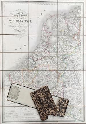
Carte Physique et RoutiŔre du Royaume des Pays-Bas, Indiquant les canaux des differentes classes, Les relais de poste et leurs distances intermediarees,
Sprache: Franz÷sisch
Verlag: Paris, J. Goujon & J. Andriveau, 1830
Anbieter: Antiquariat Im Baldreit, Baden-Baden, Deutschland
Verkńuferbewertung 5 von 5 Sternen
Das vorliegende Landkartenblatt stellt das K÷nigreich der Niederlande um 1830 dar. Als Orientierungshilfe fŘr Reisende werden jeweils die Entfernungen zwischen den Poststationen angegeben. Die Provinzgrenzen sind farbig dargestellt. Im unteren Teil der Karte findet sich eine Zeichenerklńrung sowie eine ma▀stńbliche Wiedergabe der unterschiedlichen Lńngenma▀e, wie bspw. der Seemeile, der deutschen Meile. Die Lńngengrade werden vom Pariser Meridian aus angegeben. Die Karte befindet sich in einem sehr guten Zustand, die LeinenrŘckseite ist etwas fleckig, die Kartentasche ist ebenfalls wohlerhalten, lediglich an einer Stelle merklich aber noch geringfŘgig besto▀en. Sprache: Franz÷sisch ca. 91x63 cm,auf graues Leinen aufgezogenes Kartenblatt, verso ein aufgeklebtes Hńndlerschild vom Magasine de GÚographie de Charles Simonneau, goldgeprńgte, schildpattfarbene Kartentasche mit einem RŘckenschild, die Aufschrift "Belgique et Hollande" enthaltend.
-
Carte du Gouvernement d'Alger et de la Regence de Tunis: avec une partie du bassin infe┤rieur de la Me┤diterrane┤e.
Sprache: Englisch
Verlag: J. Andriveau-Goujon, Paris, 1834
Anbieter: FOLIOS LIMITED, Oxford, Vereinigtes K÷nigreich
Verkńuferbewertung 5 von 5 Sternen
Karte
EUR 238,67
EUR 40,55 Versand
Versand von Vereinigtes K÷nigreich nach USAAnzahl: 1 verfŘgbar
In den WarenkorbNo Binding. Zustand: Very Good. Lithograph hand coloured map: 38 x 51 cm, Scale [ca. 1:675,000] (W 08░--E 11░/?N 43░--N33░), folding on linen, fitted in an original slipcase, title gilt on spine, includes insets of "Territoire d'Alger," "Golfe de Bo^ne," "Environs de Constantine," "Bougie," and "Province d'Oran." This map was published at " Classical and universal Atlas of geography ancient and modern, containing the discoveries and the most new divisions in the five parts of the world to serve on reading trips, historical works and the best drafts geography. Published by J. Andriveau-Goujon. Adopted by the Minister of War for regimental libraries. #32604.
-
![Bild des Verkńufers fŘr Carte des Royaumes d'Espagne et de Portugal [Mapa antiguo de Espa˝a y Portugal] zum Verkauf von Bolivar Old Prints Anticuario](https://pictures.abebooks.com/inventory/md/md31742336247.jpg)
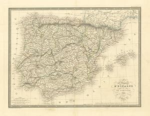
Carte des Royaumes d'Espagne et de Portugal [Mapa antiguo de Espa˝a y Portugal]
Verlag: ParÝs, 1845
Anbieter: Bolivar Old Prints Anticuario, Barcelona, B, Spanien
Verkńuferbewertung 5 von 5 Sternen
Karte
No Binding. Zustand: Bueno. Detallado mapa de Espa˝a y Portugal realizado por J. Andriveau-Goujon en 1845 y publicado en 1847 en el Atlas Classique et Universel de GÚographie Ancienne et Moderne, en ParÝs. Andriveau-Goujon (1832-1897) fue un editor y cartˇgrafo parisino que publicˇ numerosos mapas y atlas a lo largo del siglo XIX y con frecuencia trabajˇ con otros prominentes cartˇgrafos de la talla de Brue y Levasseur. El inventario de su firma editorial fue adquirido por M. Barrere en 1892. 50 x 38.5 cm. Idioma: FrancÚs. Good (bueno).
-

"Carte Physique et Routiere de La Suisse. PubliÚe par J. Andriveau-Goujon . Nouvelle ╔dition Conforme Ó l'ItinÚraire par J. Joanne".
Verlag: Paris 1850., 1850
Anbieter: Antiquariat MEINDL & SULZMANN OG, Wien - Vienna, Ísterreich
Verkńuferbewertung 5 von 5 Sternen
4░. Kupferstichkarte in 8 Segmenten auf Leinen aufgezogen und faltbar eingerichtet (ca. 49 x 74,5 cm). Die LeinenrŘckseite stellenweise leicht braunfleckig. Das Kartenbild in sauberem Erhaltungszustand.
-

Carte gÚnÚrale de l'Allemagne comprenant l' ensemble des Etats de l'Europe centrale. First editon of the map
Verlag: Paris: Andriveau-Goujon, 1849
Anbieter: Wittenborn Art Books, San Francisco, CA, USA
Verkńuferbewertung 5 von 5 Sternen
Kunst / Grafik / Poster
Zustand: Good. Map mounted on linen, folded into original chemise and slipcase.EntoilÚe de l'Allemagne placÚe sous Útui cartonnÚ vert (dim : 66 x 97 cm).OCLC Number / Unique Identifier:58676717.DatÚe de 1849 ; contours des provinces en couleurs. Excellente conditionScale [ca. 1:2,000,000], (E 1░--E 29░/N 56░--N 44░).
-
Carte GÚnÚrale Des Routes et des Chemins de Fer de La France (most probably first edition, later edition is known from 1891). - Folding map; dissected into 21 sections and mounted on linen. ca 64x79cm Lithograph. Full original color. (A highly detailed road map of France near the end of the nineteenth century. The map shows all the major roads throughout France as well as the railroads, the two transportation networks forming an impressive web covering every part of the country. This folding map was intended for use by travelers and its detail would certainly would have made it an excellent tool by those moving about France. Other details include the roads and railroads of southern England and detailed inset of Paris). In good condition (2 minor black dots - about a thumb- in the center).
Verlag: E.Andriveau-Goujon,Paris, 1887
Anbieter: Fabri Antiquariat Dr. JŘrgen Aschoff, Ulm, BW, Deutschland
Verkńuferbewertung 4 von 5 Sternen
Erstausgabe
Carte GÚnÚrale Des Routes et des Chemins de Fer de La France (most probably first edition, later edition is known from 1891). - Folding map; dissected into 21 sections and mounted on linen. ca 64x79cm Lithograph. Full original color. (A highly detailed road map of France near the end of the nineteenth century. The map shows all the major roads throughout France as well as the railroads, the two transportation networks forming an impressive web covering every part of the country. This folding map was intended for use by travelers and its detail would certainly would have made it an excellent tool by those moving about France. Other details include the roads and railroads of southern England and detailed inset of Paris). In good condition (2 minor black dots - about a thumb- in the center). 1 S.
-
CARTE DE LA MONARCHIE SUEDOISE ET DU ROYAUME DE DANEMARK'. Map of Scandinavia with inset maps of Denmark and Iceland.
Verlag: J. Andriveau 1845, 1845
Anbieter: Garwood & Voigt, Sevenoaks, Vereinigtes K÷nigreich
Verkńuferbewertung 5 von 5 Sternen
Karte
EUR 71,60
EUR 34,76 Versand
Versand von Vereinigtes K÷nigreich nach USAAnzahl: 1 verfŘgbar
In den WarenkorbZustand: Fine. 50x38cm. Original outline Colour.
-
Carte de L'Europe Orientale comprenant La Russie D'Europe L'Empire Ottoman Et La Grece.
Sprache: Franz÷sisch
Verlag: Paris, 1856
Anbieter: Antiquariat Renner OHG, Albstadt, Deutschland
Verbandsmitglied: BOEV
Verkńuferbewertung 5 von 5 Sternen
Kein Einband. Zustand: Gut. Paris 1856. Grave: le Traite par Smith; la Topographie par Gerin; les Ecritures par Rousset; les Eaux par Mmme. Fontain. Grenzkolorierte Litogr. Karte in 32 Segmenten auf Leinen montiert. Segmentgr÷▀e 23,5 x 15,5 cm. Gesamtgr÷▀e 128 x 95.5 cm. im Pappschuber. Oben rechts Titel. Unten rechts Tafel mit Erklńrungen. Unterhalb der Karte Ma▀stńbe (Myrametres, Lieues, Lieues Marines, Milles d'Allemagne, Agachs de Turquie, Verstes de Russie).- Die Karte ist leicht gebrńunt, an den Rńndern gering fleckig.
-

(United Kingdom, Eire) Carte Generale Des Iles Britanniques Contenant L'Angleterre, L'Ecosse Et L'Irlande
Sprache: Englisch
Erscheinungsdatum: 1851
Anbieter: Hornseys, Ripon, Vereinigtes K÷nigreich
Verbandsmitglied: PBFA
Verkńuferbewertung 5 von 5 Sternen
EUR 179,00
EUR 28,97 Versand
Versand von Vereinigtes K÷nigreich nach USAAnzahl: 1 verfŘgbar
In den WarenkorbNo Binding. Zustand: Very Good. Original steel engraving. Date: 1851. Sheet size: 69.4cm x 100.3cm. Original hand-colouring and good detail showing railways, canals and postal routes. Blank to the reverse. Minor age toning to the outer margins. In very good indeed, bright, clean condition. SR: Sleeve 1111. Map Drawer D.
-
Carte des Royaumes d'Espagne et de Portugal
Verlag: Spagna - Portogallo (Espa˝a - Portugal)
Anbieter: Sergio Trippini, Gavirate, VA, Italien
Verkńuferbewertung 4 von 5 Sternen
Carta geografica della Spagna e del Portogallo. Confini in coloritura coeva, piega centrale editoriale.
-

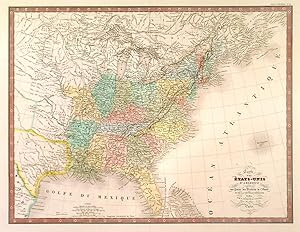
'CARTE G╔N╔RALE DES ╔TATS-UNIS ET DU MEXIQUE COMPRENANT L'AM╔RIQUE CENTRALE ET LES ANTILLES'. Large map of the United States, Mexico and West Indies, with inset maps of Central America, Lesser Antilles, New York and Long Island, and the Atlantic connections to Europe. The advancing and existing railway lines to the West are of great interest. Printed on two sheets
Verlag: Eugene Andriveau-Goujon ca. 1875, 1875
Anbieter: Garwood & Voigt, Sevenoaks, Vereinigtes K÷nigreich
Verkńuferbewertung 5 von 5 Sternen
Karte
EUR 107,40
EUR 34,76 Versand
Versand von Vereinigtes K÷nigreich nach USAAnzahl: 1 verfŘgbar
In den WarenkorbZustand: Fine. 63x92cm, when joined. Full original colour. Excellent condition.
-
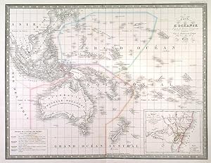
'CARTE DE L'OC╔ANIE.'. Map of Australia, East India Islands and Polynesia incl. Hawaii. Inset map of New South Wales.
Verlag: J. Andriveau-Goujon 1845, 1845
Anbieter: Garwood & Voigt, Sevenoaks, Vereinigtes K÷nigreich
Verkńuferbewertung 5 von 5 Sternen
Karte
EUR 119,34
EUR 34,76 Versand
Versand von Vereinigtes K÷nigreich nach USAAnzahl: 1 verfŘgbar
In den WarenkorbZustand: Fine. 39x50cm. Original outline colour. Excellent condition.
-

CARTE GENERALE DES ROUTES DE FRANCE, A L'USAGE DES VOYAGEURS
Verlag: Andriveau-Goujon, Paris, 1845
Karte
Pas de couverture. Zustand: bon. RO40199099: 1845. In-Plano. En feuillets. Etat d'usage, LivrÚ sans Couverture, Dos satisfaisant, IntÚrieur acceptable. Carte entoilÚe dÚpliable colorÚe, d'env. 80/65 cm. Petits dÚchirures aux pliures. 1 tache d'encre en bas de carte. Quelques trŔs petites annotations (traits). . . . Classification Dewey : 912-Atlas, cartes et plans.
-

Les etoiles fixes divisees en constellations boreales et australes d'apres le catalogue de Sir Francis Baily. Original Kupferstichkarte.
Verlag: Paris um 1850., 1850
Anbieter: Treptower Buecherkabinett Inh. Schultz Volha, Berlin, Deutschland
Verkńuferbewertung 5 von 5 Sternen
Blattgr÷▀e ca. 56 x 70 cm. Original Kupferstichkarte aus " Atlas Universel." - Leicht stockfleckig. C1 Sprache: Deutsch Gewicht in Gramm: 2000.
-

Carte Physique et Routiere de la France, de la Suisse et de l'Italie Septentrionale, indiquam aussi les Relais, leurs distances intermediaires, les Bureaux de Postes aux Lettres et les Lieux d'Etape du Royaume de France.
Verlag: Paris,, 1840
Anbieter: Llibreria AntiquÓria Delstres, Canet de Mar, B, Spanien
Verkńuferbewertung 4 von 5 Sternen
Importante mapa de caminos de rutas y postas, incluye todo el Pirineo y parte del Pais Vasco y Navarra. Mapa impreso calcograficamente, cuarteado y entelado, plegado y protegido en carpera original y estuche original. Demarcaciones coloreadas de Úpoca. Muy buen estado de conservaciˇn. 64x98 cm.
-
'CARTE DES ╔TATS-UNIS D'AM╔RIQUE.'. Map of the states east of the Mississippi and the adjacent Indian Territories to the west. Texas is shown as a separate state
Verlag: J. Andriveau-Goujon in Paris 1848, 1848
Anbieter: Garwood & Voigt, Sevenoaks, Vereinigtes K÷nigreich
Verkńuferbewertung 5 von 5 Sternen
Karte
EUR 286,41
EUR 34,76 Versand
Versand von Vereinigtes K÷nigreich nach USAAnzahl: 1 verfŘgbar
In den Warenkorb38x50cm. Full original colour with some recent additions. Excellent condition.
-
Essai sur l'Algerie pendant la domination Romaine dressee au depot general de la guerre.
Verlag: J. Andriveau-Goujon, Paris, 1843
Anbieter: FOLIOS LIMITED, Oxford, Vereinigtes K÷nigreich
Verkńuferbewertung 5 von 5 Sternen
Karte
EUR 298,34
EUR 40,55 Versand
Versand von Vereinigtes K÷nigreich nach USAAnzahl: 1 verfŘgbar
In den WarenkorbNo Binding. Zustand: Good. Folding map mounted on cloth, h. 60.5 x l. 97.3 cm on a sheet of h. 70.5 x l. 104.5 cm, 1.5 million Scales also myriametres in Roman miles 75 degree and 700 degree stage, kept in a marbled thick paper & fitted in a marbled slipcase, title gilt on spine. Since 1770 the geographers and engineers of the French Royal army started their survey of the Algerian coast which they considered as an important service for the French security. The survey achieved a fantastic collection of maps covering the whole North African maps. The importance of Algeria for French security and economy is relevant in the extensive cartographical surveys which resulted in approximately 1819 ancient maps of the country. Bibliographic reference: Archives de la DÚfense └ la dÚcouverte d'un territoire, inventaire des cartes d'Algerie conservees aux archives de la guerre du Service historique de la defense (1830-1950). By Maire-Anne de Villele and Claude Ponnou: p. 58, Numbers 102 & 103. #32598.
-
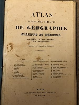
Atlas ÚlÚmentaire simplifiÚ de geographie ancienne et moderne (.).
Anbieter: Libreria Oreste Gozzini snc, Firenze, FI, Italien
Verkńuferbewertung 5 von 5 Sternen
Paris, chez Andriveau-Goujon, (c. 1850), in-folio, legatura posteriore in piena tela muta, pp. (2), + 31 carte geografiche in litografia a colori (alcuni particolari colorati a mano): 11 di geografia generale, 10 di geografia particolare dell'Europa, 10 di geografia antica e medioevale. Qualche macchia e brunitura. Un piccolo foro alla carta dell'Austria.
-
Carte gÚnÚrale des ╬les Britanniques contenant l'Angleterre, l'╔cosse et l'Irlande. Indiquant les principales routes, les canaux de navigation, &c. DressÚ d'aprŔs les cartes les plus rÚcentes
Erscheinungsdatum: 1833
Anbieter: Librairie Alain Brieux, Paris, Frankreich
Verbandsmitglied: ILAB
Verkńuferbewertung 4 von 5 Sternen
Couverture rigide. Zustand: Bon. 1 carte gravÚe, coloriÚe et Paris, J. Andriveau-Goujon, rue du Bac n░ 6, 1833, in-folio, 1 carte gravÚe, coloriÚe et entoilÚe [90 x 65 cm], dÚcoupÚe en 21 feuilles et repliÚe au format in-8, ╔tui cartonnÚ d'origine, piŔce de titre, Belle carte en couleurs, dressÚe en 1831 et revue en 1833, gravÚe par Piat et lÚgendÚe par Arnoul. Avec carte encartÚe des ţles Shetland dans l'angle supÚrieur gauche. ContrecollÚs au verso : Útiquette de l'Úditeur et catalogue de son fonds. La firme familiale J. Andriveau-Goujon poursuivra ses publications sous le nom d'E[ugŔne] Andriveau-Goujon. Cachet ex-libris de Jules Falret (1824-1902), fils du cÚlŔbre aliÚniste Jean-Pierre Falret. Infimes taches, aurÚoles trŔs pÔles. Bel exemplaire.
-
Carte Physique & Routiere de l'Italie indiquant les distances d'un Relais Ó l'autre et les dernieres divisions politiques
Verlag: Italia
Anbieter: Sergio Trippini, Gavirate, VA, Italien
Verkńuferbewertung 4 von 5 Sternen
Carta geografica dell'Italia montata su tela a stacchi. Questa carta, come dichiarato nel titolo, pone l'attenzione sull'orografia e sulla rete stradale. In merito a quest'ultima sono tracciate, lungo i percorsi, le varie distanze da una posta ad un'altra. Nell'angolo in basso a destra sono riportate alcune scale metriche "Lieues communes de France, Milles d'Italie, Milles d'Allemagne e Milles d'Angleterre". I confini sono acquerellati all'epoca. La carta Ŕ conservata nel suo astuccio coevo.
-

CARTE DE L'EMPIRE CHINOIS et Du JAPON (1850)
Erscheinungsdatum: 1850
Karte
No Binding. Zustand: As New. Highly detailed map of China, Japan, Korea and Central Asia. Colored by Kingdom and Province. Shows towns, rivers, lakes, islands, mountains, early roads and a host of other details.
-
Carte de l?AlgÚrie et de la RÚgence de Tunis d?aprŔs les documents du DÚp˘t de la Guerre et du DÚp˘t de la Marine.
Anbieter: LAM (Livres Anciens Et Modernes), MONTPELLIER, Frankreich
Verbandsmitglied: ILAB
Verkńuferbewertung 1 von 5 Sternen

P., Andriveau-Goujon, 1844. Une feuille 52 x 80 cm pliÚe et toilÚe sous emboţtage. Avec une carte d?une źPartie de la Province d?Oran╗, une carte d?une źPartie de la Province d?Alger╗, une carte d?une źPartie de la Province de Constantine╗ et une carte d?Afrique indiquant toutes les possessions franšaises en 1844.
-
Palestine Ancienne et Moderne d'aprŔs les Sources les plus authentiques
Anbieter: Librairie Laurencier, Bordeaux, AQUIT, Frankreich
Verkńuferbewertung 4 von 5 Sternen
Carte en couleurs dÚpliante dans une reliure.1857.Avec explication,plan de JÚrusalem,Golfe de Suez.Reliure petit in-8 et carte entoilÚe dÚpliÚe de format in-folio.TrŔs jolie reliure en chagrin vert dont les plats sont lergement dÚcorÚd de filets,perles,dentelles,guirlandes dorÚes.Titre au dos dans un encadrement dorÚ romantique.TBE.

![Bild des Verkńufers fŘr Carte de L'Italie Ancienne at des Contrees Adjacentes [Linen backed map of Italy c1837] zum Verkauf von Keoghs Books](https://pictures.abebooks.com/inventory/md/md22845782084.jpg)