
Gesamtpreis (1 Artikel Artikel):
Versandziel:

SMITH, J CALVIN (22 Ergebnisse)
Direkt zu den wichtigsten Suchergebnissen
Produktart
- Alle Produktarten
- Bücher (8)
- Magazine & Zeitschriften
- Comics
- Noten
- Kunst, Grafik & Poster
- Fotografien
- Karten (14)
-
Manuskripte &
Papierantiquitäten
Zustand
Einband
Weitere Eigenschaften
- Erstausgabe (1)
- Signiert
- Schutzumschlag
- Angebotsfoto (20)
Land des Verkäufers
Verkäuferbewertung
-

The Western Tourist and Emigrant\ s Guide: With a Compendious Gazetteer of the States of Ohio, Michigan, Indiana, Illinois, and Missouri, and the Terri
Verlag: GALE ECCO SABIN AMERICANA, 2012
ISBN 10: 1275784828ISBN 13: 9781275784826
Buch
Zustand: New.
-

The Illustrated Hand-Book: A New Guide for Travelers Through the United States of America: Containing a Description of the States, Cities, Towns,
Verlag: BIBLIOLIFE, 2012
ISBN 10: 1275861563ISBN 13: 9781275861565
Buch
Zustand: New.
-

The Illustrated Hand-book, a new Guide for Travelers Through the United States of America: Containing a Description of the States, Cities, Towns, Vill
Verlag: LIGHTNING SOURCE INC, 2015
ISBN 10: 1347321101ISBN 13: 9781347321102
Buch
Gebunden. Zustand: New.
-
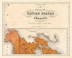
Map of the United States of America No: 12
Verlag: Theodor Fischer 1855-60, Kassel, 1855
Anbieter: Antiquariat Reinhold Berg eK Inh. R.Berg, Regensburg, Deutschland
Bewertung:

Karte
Other. Lithograph, original color in outline and wash. In excellent condition. 372 by 468mm (14 by 18 inches). 372 by 468mm (14 by 18 inches).
-

(West Canada, Lake Huron & Lake Ontario)
Verlag: Th. Fischer, Cassel, 1845
Anbieter: Antiquariat Reinhold Berg eK Inh. R.Berg, Regensburg, Deutschland
Bewertung:
Karte
Other. Lithograph, original color in outline and wash. This decorative map shows the region from West Canada, Ottawa River towards East Canada. Detailed information on the map on Lake Ontario, the Georgian Bay, Nipissing Lake, Temiscaming Lake and the Ottawa River. Inside the map are many place names, rivers, lakes, etc. engraved. As well names on Indian tribes are given. In very good to excellent condition. A few small marginal mended tears at the blank bottom (not affecting the image of the map) and a few minor marginal pin holes. 373 by 479mm (14ľ by 18ľ inches).
-
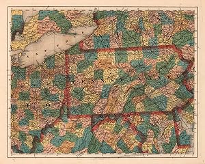
Pennsylvania No:7
Verlag: Theodor Fischer 1855-60, Kassel, 1855
Anbieter: Antiquariat Reinhold Berg eK Inh. R.Berg, Regensburg, Deutschland
Bewertung:
Karte
Other. Lithograph, original color in outline and wash. In excellent condition. 374 by 470mm (14ľ by 18˝ inches). 374 by 470mm (14ľ by 18˝ inches).
-
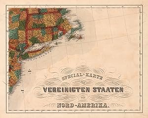
Special-Karte der Vereinigten Staaten von Nord-Amerika No: 8
Verlag: Theodor Fischer 1855-60, Kassel, 1855
Anbieter: Antiquariat Reinhold Berg eK Inh. R.Berg, Regensburg, Deutschland
Bewertung:
Karte
Other. Lithograph, original color in outline and wash. In excellent condition. 375 by 473mm (14ľ by 18˝ inches). 375 by 473mm (14ľ by 18˝ inches).
-
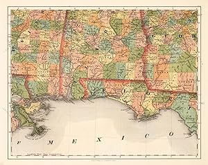
Alabama, Florida No: 14
Verlag: Theodor Fischer 1855-60, Kassel, 1855
Anbieter: Antiquariat Reinhold Berg eK Inh. R.Berg, Regensburg, Deutschland
Bewertung:
Karte
Other. Lithograph, original color in outline and wash. In excellent condition. 370 by 470mm (14˝ by 18˝ inches). 370 by 470mm (14˝ by 18˝ inches).
-
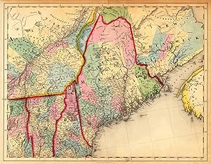
(Vermont - New Hampshire - Maine - New Brunswick)
Verlag: Th. Fischer, Cassel, 1845
Anbieter: Antiquariat Reinhold Berg eK Inh. R.Berg, Regensburg, Deutschland
Bewertung:
Karte
Other. Lithograph, hand colored in outline and wash when published. This antique map shows prominent in its centre the state of Maine with its neighboring states Vermont, New Hampshire and New Brunswick. The map extends from Salisbury in the south towards New Brunswick and the neighboring Nova Scotia. Inside the map are many place names, rivers, lakes, mountains, railroads, etc. Many counties are named and finely hand colored in wash. A detailed map of this part of the Northeastern United States by the famous 19th century mapmaker and cartographer Calvin Smith. In very good condition. A few small marginal mended tears at the blank margins, verso old backed (not affecting the image of the map). 370 by 475mm (14˝ by 18ľ inches). 370 by 475mm (14˝ by 18ľ inches).
-
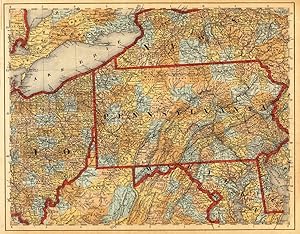
(New York - Ohio - Pennsylvania - Maryland - Delaware - Virginia)
Verlag: Th. Fischer, Cassel, 1845
Anbieter: Antiquariat Reinhold Berg eK Inh. R.Berg, Regensburg, Deutschland
Bewertung:
Karte
Other. Lithograph, hand colored in outline and wash when published. This antique map shows prominent in its centre the state of Pennsylvania with its neighboring states New York, Ohio, Delaware, Maryland and Virginia. Inside the map are many place names, rivers, lakes, mountains, railroads, etc. Many counties are named and finely hand colored in wash. A detailed map of this part of the Eastern United States by the famous 19th century mapmaker and cartographer Calvin Smith. In very good condition. A few small marginal mended tears at the blank bottom, verso old backed (not affecting the image of the map) and a few minor marginal pin holes. 373 by 476mm (14ľ by 18ľ inches). 373 by 476mm (14ľ by 18ľ inches).
-

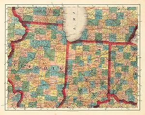
(Illinois, Indiana and Ohio)
Verlag: Th. Fischer, Cassel, 1845
Anbieter: Antiquariat Reinhold Berg eK Inh. R.Berg, Regensburg, Deutschland
Bewertung:
Karte
Other. Lithograph, original color in outline and wash. This decorative map shows Illinois, Indiana and a part of Ohio. Further the southern part of Lake Michigan is shown. Inside the map are many place names, rivers, lakes, etc. engraved. The various counties are colored in wash and explicitly detailed named. In very good to excellent condition. A few small marginal mended tears at the blank bottom (not affecting the image of the map) and a few minor marginal pin holes. 373 by 479mm (14ľ by 18ľ inches). 373 by 479mm (14ľ by 18ľ inches).
-
Illinois, Indiana No: 6
Verlag: Theodor Fischer 1855-60, Kassel, 1855
Anbieter: Antiquariat Reinhold Berg eK Inh. R.Berg, Regensburg, Deutschland
Bewertung:
Karte
Other. Lithograph, original color in outline and wash. In excellent condition. 370 by 470mm (14˝ by 18˝ inches). 370 by 470mm (14˝ by 18˝ inches).
-
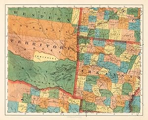
Arkansas No:9
Verlag: Theodor Fischer 1855-60, Kassel, 1855
Anbieter: Antiquariat Reinhold Berg eK Inh. R.Berg, Regensburg, Deutschland
Bewertung:
Karte
Other. Lithograph, original color in outline and wash. This very detailed map shows Arcansas, Parts of Missouri, Texas and the western Territory. In excellent condition. 375 by 467mm (14ľ by 18˝ inches). 375 by 467mm (14ľ by 18˝ inches).
-
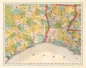
Louisiana, Texas No: 13
Verlag: Theodor Fischer 1855-60, Kassel, 1855
Anbieter: Antiquariat Reinhold Berg eK Inh. R.Berg, Regensburg, Deutschland
Bewertung:
Karte
Other. Lithograph, original color in outline and wash. 7409402836.3704701418 370 by 470mm (14˝ by 18˝ inches). 370 by 470mm (14˝ by 18˝ inches).
-
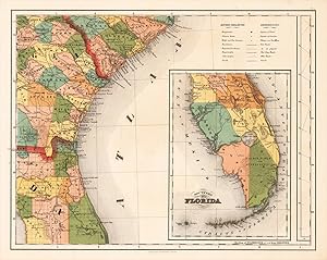
Southern Part of Florida No: 15
Verlag: Theodor Fischer 1855-60, Kassel, 1855
Anbieter: Antiquariat Reinhold Berg eK Inh. R.Berg, Regensburg, Deutschland
Bewertung:
Karte
Other. Lithograph, original color in outline and wash. In excellent condition. 370 by 470mm (14˝ by 18˝ inches).
-

A map for travelers through the United States of America showing the rail roads, canals & stage roads.
Verlag: Sherman and Smith, New York, 1849
Anbieter: Alexandre Antique Prints, Maps & Books, Toronto, ON, Kanada
Bewertung:

Karte
A decorative map. In the corners of the map are four vignettes of iconic American imagery, in the bottom right there are four inset maps, the top showing the railroads of New York to Boston, the second from New York to Philadelphia, the third from Philadelphia to Washington, the last being a map of the newly acquired territories of the West Coast. Also, beneath the title is an inset map depicting the Erie canal and the railroad between Albany and Buffalo., Size : 564x688 (mm), 22.20x27.09 (Inches), Original Outline Coloring Tears along left margin repaired and professionally restored, otherwise in very good condition, laid down in acid free tissue paper for long term preservation.
-
The Western Tourist and Emigrant's Guide, with a compendious Gazetteer of the States of Ohio, Michigan, Indiana, Illinois, and Missouri, and the Territories of Wisconsin, and Iowa
Verlag: Published by J.H. Colton, New York, 1839
Anbieter: Between the Covers-Rare Books, Inc. ABAA, Gloucester City, NJ, USA
Verbandsmitglied: ABAA ESA ILAB IOBA
Bewertung:

Erstausgabe
Hardcover. Zustand: Near Fine. First edition. 12mo. 180pp. Large folding map. Gray-green cloth gilt. Scattered foxing throughout, modest rubbing on the boards, a solid very good copy, with a small stain on the map otherwise in nice, near fine condition. *Howes* S615.
-
![Bild des Verkäufers für Special-Karte der Vereinigten Staaten von Nordamerika. [folded maps in cardboard cover] zum Verkauf von Antiquariat Reinhold Berg eK Inh. R.Berg](https://pictures.abebooks.com/inventory/md/md18492178766.jpg)
Special-Karte der Vereinigten Staaten von Nordamerika. [folded maps in cardboard cover]
Verlag: Theodor Fischer, Kassel, 1845
Anbieter: Antiquariat Reinhold Berg eK Inh. R.Berg, Regensburg, Deutschland
Bewertung:
Karte
Other. Lithograph, handcolored in wash and outline. This is the rare German edition, printed in lithograph, of Calvin Smith s large wall map of the United States of America. Complete with all 16 folded maps, to join together to a large map of the United States (including a general map of the US). A splendid detailed map, showing nicely the adjacenting Indian territories in the West, further the map is showing detailed a larger part of Texas, the gulf of Mexico and Florida. The general key map of the entire United States is extending towards the Western territories with California and Oregon, as well New Mexico and the Indian territories. Throughout all maps in excellent condition. Protected in their original cover as published. Our illustration shows all 16 folded maps digital joint together to a large wall map (56 1/2 x 72 inches). 1440 by 1840mm (56 by 72 inches). 1440 by 1840mm (56 by 72 inches).
-

The Illustrated Hand-Book, A New Guide for Travelers through the United States.Accompanied by a Large and Accurate Map
Verlag: Sherman & Smith, 122 Broadway, New York, 1849
Anbieter: James Cummins Bookseller, ABAA, New York, NY, USA
Bewertung:
Illustrated with 125 engravings in the text. Large folding map by Smith (22 x 25 3/4 inches) at the back, outlined in period color ("A New Map for Travellers throught the United States", New York Sherman & Smith, 1849"). [2, ads], 234 pp. 1 vols. 12mo. An important map of the U.S., first published in the 1846 edition, which was updated for the editions of 1848, 1849 (this), and 1850, then published separately in 1853 and 1853. With five insets to the general map: "Railroad & Canal Routes from Albany to Buffalo," "Map Showing the Rail Roads between the Cities of New York, Boston & Albany," (mostly missing in this copy), "Railroad Route from New York to Philadelphia," "Railroad Route from Philadelphia to Washington" and "Map of Oregon Northern California Santa Fe &c." The latter inset (first published in the 1846 edition), although small, is important for showing regions before the Mexican War, and was copied by other map makers. Howes S 614; Sabin 82928; Wheat 56 (ref) Original green gilt-stamped cloth, with slight wear at extremities. One piece missing from right edge of map (approximately 3 x 3 inches), affecting one inset Illustrated with 125 engravings in the text. Large folding map by Smith (22 x 25 3/4 inches) at the back, outlined in period color ("A New Map for Travellers throught the United States", New York Sherman & Smith, 1849"). [2, ads], 234 pp. 1 vols. 12mo.
-

A Complete Descriptive and Statistical Gazetteer
Verlag: WENTWORTH PR, 2019
ISBN 10: 0530378205ISBN 13: 9780530378206
Buch
Gebunden. Zustand: New.
-

The Illustrated Hand-book, a new Guide for Travelers Through the United States of America .
Verlag: LIGHTNING SOURCE INC, 2016
ISBN 10: 1359184368ISBN 13: 9781359184368
Buch
Gebunden. Zustand: New. KlappentextThis work has been selected by scholars as being culturally important, and is part of the knowledge base of civilization as we know it. This work was reproduced from the original artifact, and remains as true to the original w.
-
Mit hauptsächlicher Berücksichtigung der Eisenbahn, Telegraphen, Dampfschiffen, . Posten, Angabe der Entfernungen und Beigabe vieler . Notizen für Reisende und Auswanderer. Nach J. Calvin Smith, . H. Tanner und jeweilig anderen neuesten Quellen bearbeitet u. in Stahl gestochen in der Kunst- u. geogr. Anstalt Serz . in Nürnberg. Bamberg: Verlag der Buchner'schen Buchhandlung, 1852. Orig.-Halbleinen-Mappe mit Kordelbindung. 28 Textseiten mit Register und mehrfach gefaltete, grenzkolorierte Karte (53,5 x 72 cm). * Zweite, seltene Ausgabe. - Howes (N57) lists related imprints from 1853 and 1855. Wheat (Maps of the California Gold Region 274) lists an 1855 edition, but with the same insets. Not in Phillips, who lists the 1853 version that appeared in Trautgott Bromme's 1853 guide (p. 903). This map was undoubtedly used by emigration agents and others in Germany to induce people to move to the expanding western regions of the United States, such as Texas, California, and Oregon. The chief feature of the map relating to the West is the large inset map showing routes to California and Oregon. No doubt the recent discovery of gold in California made this map even more useful and desirable. The insets are particularly interesting since they show the two main arrival ports in some detail and the overland routes to Oregon, Sacramento, and Los Angeles. Texas extends as far west as Goliad. New Mexico is labeled "Santa Fe" and reaches almost to Fort Laramie. - Einband berieben u. bestoßen; Textteil mit stärkeren Gebrauchsspuren; Faltkarte grenzkoloriert u. mit einem ca. 11 cm Einriss in der Faltung. - Sehr seltene deutsche Auswanderer-Karte !.

