Gesamtpreis (1 Artikel Artikel):
Versandziel:

SEUTTER, GEORG MATTHAEUS (12 Ergebnisse)
Direkt zu den wichtigsten Suchergebnissen
Produktart
- Alle Produktarten
- Bücher (7)
- Magazine & Zeitschriften
- Comics
- Noten
- Kunst, Grafik & Poster (2)
- Fotografien
- Karten (3)
-
Manuskripte &
Papierantiquitäten
Zustand
- Alle
- Neu
- Antiquarisch/Gebraucht
Einband
Weitere Eigenschaften
- Erstausgabe
- Signiert
- Schutzumschlag
- Angebotsfoto (10)
Land des Verkäufers
Verkäuferbewertung
-

Silesiae Ducatus tam Superior quam Inferior juxta suos XVII minores principatus et VI libera dominia disterminat. nova mappa geographica ob oculos positus Cura et Sumtibus
Verlag: Matth. Seutter, August[ae Vindelicorum]
ca. 1730 . Altkolorierte Kupferstichkarte, mit zwei wunderschönen Kartuschen Bugfalte. Landkarte: (Latein) + kleinformatige Abb. der Stadt Breslaw [Breslau] : kleiner Stadtplan untere Ecke links, die Karte ist gerahmt und befindet sich in einem guten Zustand. Auf Wunsch Foto Size: 55,5x 63cm.
-
Holsatiae Mappa universalis in suos Ducatus nimirum Holsatiam in Specie Dithmarsiam, Stormariam, Wagriam, accurate distincta Cura et impensis. -
Verlag: Augsburg: Seutter [um ]. -, 1750
Kunst / Grafik / Poster
Kupferstich 49,5 x 58 cm Bildgröße, 52 x 60 cm Blattgröße. Das Herzogtum Holstein, am oberen Bildrand das Herzogtum Schleswig mit Eiderstedt und der Eckernförder Bucht. Am unteren Bildrand der Elblauf. In der rechten unteren Ecke eine figürliche Kartusche und dem Wappen von Holstein. Unten links eine kleine Kartusche mit Meilenanzeiger, Figuren und den Wappen von Dithmarschen, Stormarn und Wagrien. Zart grenzkoloriert. - Georg Matthäus Seutter, 1678-1757, Geograph, Kartograph, Graveur und Herausgeber in Augsburg. - Die rückseitig verstärkte Mittelfalte zart gebräunt, das Blatt leicht fingerfleckig. In der rechten Blatthälfte Abklatsch der Grenzlinien von der linken Seite.
-

Holsatiae Mappa universalis in suos Ducatus nimirum Holsatiam in Specie Dithmarsiam, Stormariam, Wagriam, accurate distincta Cura et impensis. -
Verlag: Augsburg: Seutter [um ]. -, 1750
Kunst / Grafik / Poster
Altkolorierter Kupferstich 49,5 x 58 cm Bildgröße, 53 x 61 cm Blattgröße. Das Herzogtum Holstein, am oberen Bildrand das Herzogtum Schleswig mit Eiderstedt und der Eckernförder Bucht. Am unteren Bildrand der Elblauf. In der rechten unteren Ecke eine figürliche Kartusche und dem Wappen von Holstein. Unten links eine kleine Kartusche mit Meilenanzeiger, Figuren und den Wappen von Dithmarschen, Stormarn und Wagrien. Die holsteinischen Gebiete flächig koloriert, außerhalb davon grenzkoloriert. - Georg Matthäus Seutter 1678-1757 Geograph, Kartograph, Graveur und Verleger in Augsburg. - Rückseitig Spuren einer früheren Rahmung. Das Blatt komplett minimal stockfleckig, der Druck klar.
-
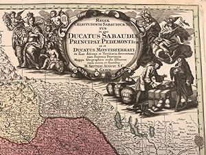
Regiae Celsitudinis Sabaudicae status in quo Ducatus Sabaudiae Principat Pedemontium et Ducatus Montisferrati.
Verlag: (Augsburg), sine data (1730 circa),, 1730
Anbieter: Libreria Antiquaria Pregliasco, Torino, Italien
Bewertung:

Zustand: molto buono. Incisione in rame mm 500 x 570 arricchita da bella coloritura coeva. Titolo inciso entro grande ed elaborato cartiglio in bianco nero, raffigurante una scena mercantile, posto nella porzione superiore destra del rame. Nell'angolo in basso a destra sono riportate le scale grafiche "Milliaria Germanica communia 15 in uno gradu" e "Miliaria Italica communia". La carta ripropone, modificandone il cartiglio, quella di J.B. Homann, del quale Seutter era stato collaboratore. Matthia Seutter di Augsburg (1678-1757) fu allievo di Homann e ne continuň l'attivitŕ come cartografo, incisore ed editore di atlanti. Carta geografica dei territori del Piemonte e della Savoia Bell'esemplare con qualche piccolo strappetto abilmente restaurato nel margine superiore bianco. G. Aliprandi, Le grandi Alpi ( 2005), p. 288 (v. 1); F. Barrera, Il Piemonte nella cartografia del Settecento, n. 30 ; Torino e il suo orizzonte, n. 107 e n. 123. Book.
-
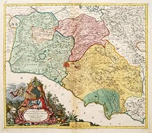
Gli Stati DEL SOMMO PONTEFICE chiamati IL PARTIMONIO DI ST PIETRO Rome.
Verlag: Ausberg. [c.1740], 1740
Anbieter: Peter Harrington. ABA/ ILAB., London, Vereinigtes Königreich
Verbandsmitglied: ABA ILAB PBFA
Bewertung:
A splendid map of the area surrounding Rome, with regions clearly delineated. Magnificent baroque cartouche with title surrounded by ornate shell, in a woodland landscape whilst above,there is a regal tent containing a gold crown guarded by cherubs. Copper engraving. Original colour. Fine condition. Slight discolouration to the central fold. Size: 56 x 48 cm.
-

Representation la plus nouvelle et exacte de l'Ile Martinique.
Verlag: Ausberg. c1750, 1750
Anbieter: Peter Harrington. ABA/ ILAB., London, Vereinigtes Königreich
Verbandsmitglied: ABA ILAB PBFA
Bewertung:
A truly superb and very beautiful large scale map of this idyllic French Caribbean island with an extremely decorative cartouche that depicts the native islanders meeting and trading with Europeans. The cartouche is uncoloured. Compass roses and rhumb lines abound. This map displays all of Seutter's extensive engraving skills. Copper engraving. Original colour. Overall in excellent condition but small stain (approx 0.5 x 2cm) left-hand bottom edge Size: 56.2 x 49 cm.
-

Insula et Regnum Sardinia.
Verlag: Augsburg 1730 ca., 1730
Anbieter: Libreria Antiquaria Pregliasco, Torino, Italien
Bewertung:
Zustand: molto buono. Incisione originale su rame, mm 500 x 580 e margini, abilmente colorata da mano coeva. Bella e raffinata carta geografica della Sardegna tratta dall'Atlas Novus del Seutter pubblicato ad Augsburg nel 1730 ca In alto a sinistra il titolo entro importante cartiglio animato da personaggi, flora e fauna di carattere allegorico. In basso altri due cartigli con le scale metriche e lo stemma di Vittorio Amedeo II di Savoia, nel quale č inserito anche lo stemma sardo. La mappa č basata sulla medesima rappresentazione dell'isola disegnata dal Coronelli nel 1680. Bell'esemplare in bella colorazione d'epoca. Piloni n. LXVII. Book.
-
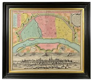
Colonia Agrippina. Cölln.
Verlag: Seutter Augsburg ca, 1730
Anbieter: Shapero Rare Books, London, Vereinigtes Königreich
Verbandsmitglied: ABA ILAB PBFA
Bewertung:

Karte
Double-page engraved plan (49x56.5 cm) with full contemporary body wash colour. Framed dimensions: 63 x 71cm. A bright and detailed plan of Cologne, in full contemporary colour with a panoramic view of the city from across the river Rhein. Seutter's plan emphasises the city's status as a major harbour and flourishing trading city, demonstrated by the many ships entering and exiting the city and the shipbuilding site in the plan's vignette. It also highlights Cologne's security thanks to its strong city walls and towers, in contrast to the area of Deutz across the river, which lacks fortifications. As well as the city's major ports, the plan's key primarily notes the city's important churches. Cologne was considered a 'daughter of Rome' due to its position as a sovereign state within the Holy Roman Empire. The most important of Cologne's 'magnificent 365 churches' are marked, including the Church of Saint Ursula, the site upon which the 11,000 virgins associated with Saint Ursula are said to be buried. Seutter (1647-1756) was one of the most important and prolific German map publishers of the 18th century. He was apprenticed in Nuremberg to Johann Bapist Homann, the leading German cartographic publisher of the period. Having finished his training he left to establish his own independent cartographic publishing house in Augsburg. By 1732 Seutter was one of the most celebrated publishers of his time and was honored by the German Emperor Charles VI with the title of "Imperial Geographer". Krudewig 154; Fauser 6717.
-
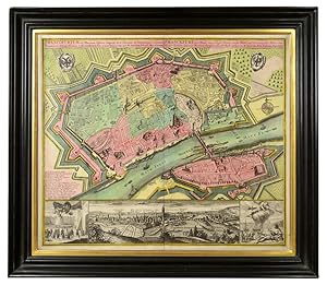
Frankfurt. Plan-Prospekt.
Verlag: Seutter Augsburg ca, 1730
Anbieter: Shapero Rare Books, London, Vereinigtes Königreich
Verbandsmitglied: ABA ILAB PBFA
Bewertung:
Karte
Double-page engraved plan (49 x 57 cm) with full contemporary body wash colour. Framed dimensions: 63 x 70 cm. Fine plan of Frankfurt in full contemporary colour, with a panoramic view of the city and the river Main. Seutter's plan celebrates Frankfurt as an Imperial Free City under the Holy Roman Empire, famed for its status as a flourishing trading city. Its trading success is suggested by Frankfurt am Main's row of busy ports and the large docked ship entering Sachsenhausen across the river. It is also overtly signalled by the right hand panel of the prospect showing Hermes, the Greek god of trade and commerce, showering an allegorical depiction of the city with riches. Meanwhile Frankfurt's might is emphasised by the city walls and fortifications, and by the left hand panel of the prospect, depicting the German imperial eagle hovering commandingly above troops. The plan's alphabetical key identifies the city's key sites, the majority of which are churches. Meanwhile the city's outskirts are designated as rich agricultural land, both in the plan itself and central panel of the prospect. Seutter (1647-1756) was one of the most important and prolific German map publishers of the 18th century. He was apprenticed in Nuremberg to Johann Bapist Homann, the leading German cartographic publisher of the period. Having finished his training he left to establish his own independent cartographic publishing house in Augsburg. By 1732 Seutter was one of the most celebrated publishers of his time and was honored by the German Emperor Charles VI with the title of "Imperial Geographer". Fauser 4115.
-
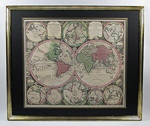
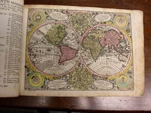
Weltkarte, 4 Kontinentkarten und Himmelskarte.
Verlag: Augsburg, G.M. Seutter, um., 1730
Anbieter: Antiquariat F. Neidhardt, Böblingen, Deutschland
Bewertung:
Karte
Uniformer Satz 6 altkolorierter Kupferstichkarten, Abbildungen ca. 50 x 58 cm. Unter Glas gerahmt, 68 x 80 cm. Sehr dekorative Karten im Verlagskolorit und in guten Abzügen. Die Welt- und Himmelskarte mit je 2 Hemisphären und 12 bzw. 7 weiteren Darstellungen im Rund wie Polprojektionen und Sonnensystem nach Ptolemäus, Kopernikus und Tycho Brahe. Die Himmels- und Kontinentkarten verfügen zudem über je 1-2 figürliche, dekorative Titelkartuschen. Aus "Atlas novus sive tabulae geographicae totius orbis".- G.M. Seutter (1678-1757) lernte in der Homann'schen Offizin, bevor er 1707 nach Augsburg ging und dort einen eigenen, später sehr erfolgreichen Verlag gründete.- Die Himmelskarte und Europa mit kleinem hinterlegten Einriss, Bugfalten teils minimal geöffnet, Amerika und Europa mit zwei bzw. drei schwachen, unauffälligen Braunflecken in der Abbildung, Himmelskarte mit Bräunung im Rand, teils minimal fingerfleckig. Das feste Papier sauber und insgesamt sehr schön erhalten. Fachmännisch gerahmt in Echtgoldleisten unter schwarzen Zierpassepartouts und Glas in Museumsqualität.- Sandler S. 14f. Phillips/Le Gear 593. Warner S. 245, 1a (zur Himmelskarte).
-
Atlas Minor.
Verlag: Augsburg: [c1744]., 1744
Anbieter: D & E LAKE LTD. (ABAC/ILAB), Toronto, ON, Kanada
Bewertung:

Soft cover. Zustand: Very Good. oblong folio. [pp. 34]. hand-coloured engraved title with an elaborate allegorical border of the Continents, Empire and the Gods by Martin Gottfrid Crophius after Jacob Christoph Weyerman & 65 hand-coloured engraved maps by Tobias Conrad Lotter, Albrecht Carl Seutter, & Andreas Silbereisen after Matthäus Seutter & Albrecht Carl Seutter. woodcut tailpiece. contemporary limp calf (rubbed & cockled, edges chipped, staining to portion of last 4 maps, scattered foxing & some marginal dampstaining & minor tears, several tiny wormholes in first few leaves). An attractive atlas by one of the leading eighteenth century German map publishers and engravers. Including maps of the world, North America, South America, Asia, Africa, Russia, the Turkish Empire, Southern Russia and the Crimea, the Holy Land, and various countries and regions of Europe. The map of Genoa, by Matthäus Petter Läinpacher, does not appear in the index. cfNordenskiöld 283 (67 maps; 4 not listed in index). cfPhillips, Atlases, 3494 (68 maps: 4 not listed in index).
-
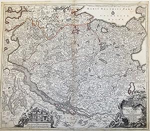
Synopsis Plagae septemtrionalis sive Sueciae Daniae et Norvegiae Regn.
(Wien, ca. 1730) (49x58,5 cm.). Kobberstukket, hĺndkoloreet Skandinavienskort med Estland, Letland, Litauen og det vestlige Rusland. Velbevaret indrammet under glas i fin ramme af brun birketrćsfiner. Hĺndkolorereingen en smule svag. Kortet er fra Seutter's "Atlas Novus", som blev udgivet 1730-35.