Gesamtpreis (1 Artikel Artikel):
Versandziel:

RIZZI, GIOVANNI (46 Ergebnisse)
Direkt zu den wichtigsten Suchergebnissen
Produktart
- Alle Produktarten
- Bücher (23)
- Magazine & Zeitschriften
- Comics
- Noten
- Kunst, Grafik & Poster (1)
- Fotografien
- Karten (22)
-
Manuskripte &
Papierantiquitäten
Zustand
Einband
Weitere Eigenschaften
- Erstausgabe
- Signiert
- Schutzumschlag
- Angebotsfoto (40)
Land des Verkäufers
Verkäuferbewertung
-
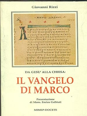
Zustand: Buone. italiano Condizioni dell'esterno: Buone Condizioni dell'interno: Buone.
-
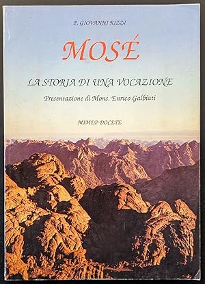
Mosé. La storia di una vocazione
Verlag: Pessano
Anbieter: Sergio Trippini, Gavirate, Italien
Bewertung:

Libro vintage. Argomento: Spiritualitŕ. Autore: Rizzi Giovanni. Editore: MiMEP-DOCETE. Luogo: Pessano. Anno: 1988. Formato: in-8°. Pagg: 138. Legatura: Brossura. Conservazione: buona. Note a matita in prima bianca. Illustrazioni in bn all'interno del testo.
-

Gebunden. Zustand: New.
-
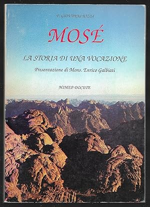
Mosé - La storia di una vocazione
Verlag: Milano
Anbieter: Sergio Trippini, Gavirate, Italien
Bewertung:
Libro vintage in-8°, brossura di pagg 137, Milano 1988. Religione. Illustrazioni in bn fuori testo. Buono stato di cosneravzione.
-
L'Alemagne Divisee par Cercles." - Deutschland Deutsches Reich Preußen Polen Österreich Ungarn Allemagne Germany
Verlag: Paris, 1770
Anbieter: Antiquariat Steffen Völkel GmbH, Seubersdorf, Deutschland
Bewertung:
Kunst / Grafik / Poster
Original handkolorierte Kupferstich-Karte von ca. 1770. -- Blattmasse: ca. 39 cm x 53 cm, Kartenmasse: ca. 31 cm x 45 cm. -- gut erhalten. || -- Original hand-colored engraved map from around 1770. -- in very good condition. || Dies ist ein Original! - Kein Nachdruck! - Keine Kopie! -- This is an original! - No copy! - No reprint! Sprache: Deutsch Gewicht in Gramm: 1550.
-
L'Alemagne Divisee par Cercles." - Deutschland Deutsches Reich Preußen Polen Österreich Ungarn Allemagne Germany
Verlag: Paris, 1770
Anbieter: Antiquariat Steffen Völkel GmbH, Seubersdorf, Deutschland
Bewertung:
Karte
Original handkolorierte Kupferstich-Karte von ca. 1770. -- Blattmasse: ca. 37 cm x 54 cm. -- gut erhalten. || -- Original hand-colored engraved map from around 1770. -- in very good condition. || Dies ist ein Original! - Kein Nachdruck! - Keine Kopie! -- This is an original! - No copy! - No reprint! Sprache: Französisch Gewicht in Gramm: 1550.
-
L'Alemagne Divisee par Cercles." - Deutschland Deutsches Reich Preußen Polen Österreich Ungarn Allemagne Germany
Verlag: Paris, 1770
Anbieter: Antiquariat Steffen Völkel GmbH, Seubersdorf, Deutschland
Bewertung:
Karte
Original handkolorierte Kupferstich-Karte von ca. 1770. -- Blattmasse: ca. 37 x 53 cm. -- im seitlichen Außenrand mit altem montierten Blattweiser. -- im unteren Mittelbug leicht eingerissen, mit zwei winzigen Wurmlöchlein, sonst gut erhalten. || Original hand-colored engraved map from c. 1770. -- in the side margin with an old mounted page marker. -- with a split on the lower part of the centerfold, with two very small wormholes, otherwise in very good condition. || Dies ist ein Original! - Kein Nachdruck! - Keine Kopie! -- This is an original! - No copy! - No reprint! Sprache: Französisch Gewicht in Gramm: 1550.
-
L'Alemagne Divisee par Cercles." - Deutschland Deutsches Reich Preußen Polen Österreich Ungarn Allemagne Germany
Verlag: Paris, 1770
Anbieter: Antiquariat Steffen Völkel GmbH, Seubersdorf, Deutschland
Bewertung:
Karte
Original handkolorierte Kupferstich-Karte von ca. 1770. -- Blattmasse: ca. 37 x 53 cm. -- im unteren Mittelbug leicht eingerissen, leicht fleckig im Außenrand, sonst gut erhalten. || Original hand-colored engraved map from c. 1770. -- with a split on the lower part of the centerfold, stained in the outer margins, otherwise in very good condition. Sprache: Französisch Gewicht in Gramm: 1550.
-

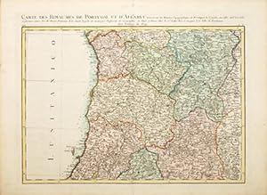
Mapa dos Reynos de Portugal e Algarve feita sobre as Memorias Topografica de D. Vasque de Cozuela as do P. Lacerda e varias outras. // Carte des Royaumes de Portugal et d'Algarve." - Portugal Algarve map Karte
Verlag: Paris ca. 1760., 1760
Anbieter: Antiquariat Steffen Völkel GmbH, Seubersdorf, Deutschland
Bewertung:
Karte
Original handkolorierte Kupferstich-Karte von ca. 1760. Von 2 Platten gedruckt. -- Blattmasse: jede Karte ca. 37 x 53 cm. Zusammen: ca. 74 x 53 cm. -- gut erhalten. || Original hand-colored engraved map from c. 1760. Printed on two plates. -- in very good condition. || Dies ist ein Original! - Kein Nachdruck! - Keine Kopie! -- This is an original! - No copy! - No reprint! pt Gewicht in Gramm: 50.
-
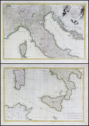
L'Italie divisee en ses differens Etats." - Italy Italien Italia Sardegna Sicilia Corsica Corse Sizilien Sardinien
Verlag: Paris, 1770
Anbieter: Antiquariat Steffen Völkel GmbH, Seubersdorf, Deutschland
Bewertung:
Karte
Original handkolorierte Kupferstich-Karte von ca. 1770. Von 2 Platten gedruckt - zusammensetzbar. -- Blattmasse: jede Karte ca. 37 cm x 53 cm. fleckig im Außenrand, obere Karte mit Hinterlegung im unteren Mittelbug, untere Karte mit Einzeichnung einer Seereise im 18. Jh., sonst gut erhalten. || Original hand-colored engraved map from around 1770. -- rare two sheet map! - stained in the outer margins, upper map with deposit in the lower middle bow, lower map with an illustration of a sea voyage in the 18th century, otherwise in very good condition. Sprache: Französisch Gewicht in Gramm: 35.
-
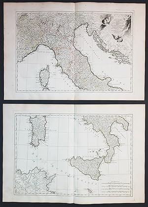
L'Italie divisee en ses differens Etats." - Italy Italien Italia Sardegna Sicilia Corsica Corse Sizilien Sardinien
Verlag: Paris, 1770
Anbieter: Antiquariat Steffen Völkel GmbH, Seubersdorf, Deutschland
Bewertung:
Karte
Original handkolorierte Kupferstich-Karte von ca. 1770. Von 2 Platten gedruckt - zusammensetzbar. -- Blattmasse: jede Karte ca. 37 cm x 54 cm. -- gut erhalten. || Original hand-colored engraved map from around 1770. -- rare two sheet map! - in very good condition. || Dies ist ein Original! - Kein Nachdruck! - Keine Kopie! -- This is an original! - No copy! - No reprint! Sprache: Französisch Gewicht in Gramm: 1550.
-
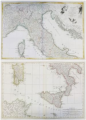
L'Italie divisee en ses differens Etats." - Italy Italien Italia Sardegna Sicilia Corsica Corse Sizilien Sardinien
Verlag: Paris, 1770
Anbieter: Antiquariat Steffen Völkel GmbH, Seubersdorf, Deutschland
Bewertung:
Karte
Original handkolorierte Kupferstich-Karte von ca. 1770. Von 2 Platten gedruckt - zusammensetzbar. -- Blattmasse: jede Karte ca. 37 cm x 53 cm. im seitlichen Außenrand mit altem montierten Blattweiser. -- je mit zwei winzigen Wurmlöchlein, sonst gut erhalten. || Original hand-colored engraved map from around 1770. -- rare two sheet map! - in the side margin with an old mounted page marker. - with two minor wormholes on each map, otherwise in very good condition. || Dies ist ein Original! - Kein Nachdruck! - Keine Kopie! -- This is an original! - No copy! - No reprint! Sprache: Französisch Gewicht in Gramm: 1550.
-
Carte des Royaumes de Portugal et Algarve
Verlag: Paris: 1762, 1762
Anbieter: Peter Harrington. ABA/ ILAB., London, Vereinigtes Königreich
Verbandsmitglied: ABA ILAB PBFA
Bewertung:
A beautifully engraved map with excellent detail of northern Portugal, and small portions of Leon and L'Estremadura in Spain. Rizzi-Zannoni was a geographer and astronomer, who became the Chief hydrographer to the Dépôt des cartes et plans de la Marine. He worked on Lattré's Atlas Moderne, together with Bonne and Janvier. Size: 375 x500 mm. Copperplate engraving with original wash colour. Very good condition.
-

Carte Geo-Hydrographique du Golfe du Mexique et de ses Isles." - America Caribbean Florida Cuba Golf of Mexico Amerika Mexiko map Karte carte
Verlag: Paris, 1770
Anbieter: Antiquariat Steffen Völkel GmbH, Seubersdorf, Deutschland
Bewertung:
Karte
Original handkolorierte Kupferstich-Karte von ca. 1770. -- Blattmasse: 37 cm x 54 cm. -- teils leicht fleckig, sonst gut erhalten. || -- Original hand-colored engraved map from 1770. -- partly slightly stained, otherwise in very good condition. Sprache: Französisch Gewicht in Gramm: 1550.
-

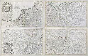
Carte de L'Empire D'Alemagne avec les Etats de Boheme. / Dediee et Presentee a S. E. Monseigueur J. D. Almoreau Tiepolo." - Deutschland Deutsches Reich Germany Polen Polska Österreich Böhmen Czech Austria Pommern Preußen Hungary Ungarn Ostpreußen Westpreußen Karte map
Verlag: Paris, 1783
Anbieter: Antiquariat Steffen Völkel GmbH, Seubersdorf, Deutschland
Bewertung:
Karte
Original handkolorierte Kupferstich-Karte von ca. 1783. Von 4 Platten gedruckt. -- Blattmasse: jede Karte ca. 37 cm x 54 cm. -- 4 Karten! - gut erhalten. || -- Original hand-colored engraved map from around 1783. -- rare four sheet map of the German Empire! - in very good condition. || Dies ist ein Original! - Kein Nachdruck! - Keine Kopie! -- This is an original! - No copy! - No reprint! Sprache: Französisch Gewicht in Gramm: 1550.
-
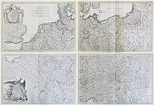
Carte de L'Empire D'Alemagne avec les Etats de Boheme. / Dediee et Presentee a S. E. Monseigueur J. D. Almoreau Tiepolo." - Deutschland Deutsches Reich Germany Polen Polska Österreich Böhmen Czech Austria Pommern Preußen Hungary Ungarn Ostpreußen Westpreußen Karte map
Verlag: Paris, 1783
Anbieter: Antiquariat Steffen Völkel GmbH, Seubersdorf, Deutschland
Bewertung:
Karte
Original handkolorierte Kupferstich-Karte von 1783. Von 4 Platten gedruckt. 4 Karten! -- Blattmasse: jede Karte ca. 37 x 53 cm. -- im seitlichen Außenrand mit altem montierten Blattweiser. -- in den Außenrändern teils etwas fleckig, sonst gut erhalten. || Original hand-colored engraved map from 1783. Printed on four plates. Rare four-sheet map of the German Empire. -- in the side margin with an old mounted page marker. -- with some staining on the outer margins, otherwise in very good condition. || Dies ist ein Original! - Kein Nachdruck! - Keine Kopie! -- This is an original! - No copy! - No reprint! Sprache: Französisch Gewicht in Gramm: 1550.
-
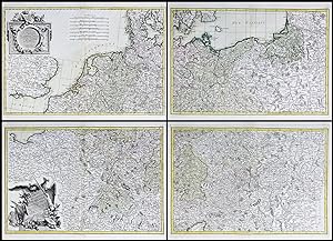
Carte de L'Empire D'Alemagne avec les Etats de Boheme. / Dediee et Presentee a S. E. Monseigueur J. D. Almoreau Tiepolo." - Deutschland Deutsches Reich Germany Polen Polska Österreich Böhmen Czech Austria Pommern Preußen Hungary Ungarn Ostpreußen Westpreußen Karte map
Verlag: Paris, 1783
Anbieter: Antiquariat Steffen Völkel GmbH, Seubersdorf, Deutschland
Bewertung:
Karte
Original handkolorierte Kupferstich-Karte von 1783. Von 4 Platten gedruckt. 4 Karten! Seltene Wandkarte von Deutschland. -- Blattmasse: jede Karte ca. 39 x 53 cm. -- gut erhalten. || Original hand-colored engraved map from 1783. Printed on four plates. Rare four-sheet map of the German Empire. -- in very good condition. || Dies ist ein Original! - Kein Nachdruck! - Keine Kopie! -- This is an original! - No copy! - No reprint! Sprache: Französisch Gewicht in Gramm: 1550.
-
Carte de L'Empire D'Alemagne avec les Etats de Boheme. / Dediee et Presentee a S. E. Monseigueur J. D. Almoreau Tiepolo." - Deutschland Deutsches Reich Germany Polen Polska Österreich Böhmen Czech Austria Pommern Preußen Hungary Ungarn Ostpreußen Westpreußen Karte map
Verlag: Paris, 1783
Anbieter: Antiquariat Steffen Völkel GmbH, Seubersdorf, Deutschland
Bewertung:
Karte
Original handkolorierte Kupferstich-Karte von 1783. Von 4 Platten gedruckt. 4 Karten! Seltene Wandkarte von Deutschland. -- Blattmasse: jede Karte ca. 39 x 53 cm. -- teils leicht fleckig, im unteren Mittelbug leicht eingerissen, sonst gut erhalten. || Original hand-colored engraved map from 1783. Printed on four plates. Rare four-sheet map of the German Empire. -- partly slightly stained, with slight tear in the lower centerfold, otherwise in very good condition. Sprache: Französisch Gewicht in Gramm: 1550.
-
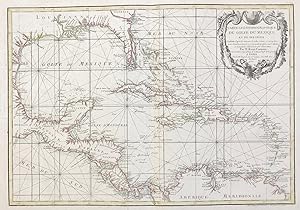
Carte Geo-Hydrographique du Golfe du Mexique et de ses Isles." - America Caribbean Florida Cuba Golf of Mexico Amerika Mexiko map Karte carte
Verlag: Paris, 1770
Anbieter: Antiquariat Steffen Völkel GmbH, Seubersdorf, Deutschland
Bewertung:
Karte
Original handkolorierte Kupferstich-Karte von ca. 1770. -- Blattmasse: 37 cm x 54 cm. -- im seitlichen Außenrand mit altem montierten Blattweiser. - gut erhalten. || -- Original hand-colored engraved map from 1770. -- in the side margin with an old mounted page marker. -- in very good condition. || Dies ist ein Original! - Kein Nachdruck! - Keine Kopie! -- This is an original! - No copy! - No reprint! Sprache: Französisch Gewicht in Gramm: 1550.
-

L'Alemagne divisée par Cercles.
Verlag: Parigi, 1762
Anbieter: Libreria Ex Libris ALAI-ILAB/LILA member, Roma, Italien
Bewertung:
Karte
Carta geografica originale (cm. 45x31 piů ampi margini). Coloritura coeva all'acquerello dei confini. Ottimo esemplare.
-
Dediée et Présentée ŕ S.E. Monseigneur J.D. Almoreau Tiepolo.
Verlag: Parigi, 1762
Anbieter: Libreria Ex Libris ALAI-ILAB/LILA member, Roma, Italien
Bewertung:
Karte
Carta geografica originale (cm. 46x31 piů ampi margini). Coloritura coeva all'acquerello dei confini. Ottimo esemplare.
-
(L'Italie divisée en ses differens Etats. partie meridionale)
Verlag: Parigi, 1762
Anbieter: Libreria Ex Libris ALAI-ILAB/LILA member, Roma, Italien
Bewertung:
Karte
Carta geografica originale (cm. 46x31 piů ampi margini). Coloritura coeva all'acquerello dei confini. Ottimo esemplare.
-
![Bild des Verkäufers für [Six untitled maps of Calabria.] zum Verkauf von Altea Antique Maps](https://pictures.abebooks.com/inventory/md/md17119160853.jpg)
[Six untitled maps of Calabria.]
Erscheinungsdatum: 1812
Anbieter: Altea Antique Maps, London, Vereinigtes Königreich
Verbandsmitglied: ABA ILAB PBFA
Bewertung:
Karte
No Binding. Zustand: Good. Naples, 1794-1812. Six sheets, each 525 x 770mm. Each sheet with the ink stamp of the 'Depot de la Marine'. The six maps of the whole region of Calabria engraved by Giuseppe Guerra in 1794 for Rizzi-Zannoni's 'Atlante Geografico del Regno di Napoli', completed in 1812. The incredibly-detailed sheets show relief with hatchuring and have vignette ships decorating the seas. Rizzi-Zannoni (1736-1814) started his 31-sheet map of the Kingdom of Naples in 1788, under the Bourbon monarch Ferdinand IV. He continued his work under the rules of Joseph Bonaparte and Joachim Murat, taking the role of head of the 'Deposito Topografico' in 1807. The quality of the work has led him to be regarded as the most influential Italian cartographer since Magini.
-
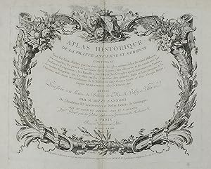
Atlas Historique de la France Ancienne et Moderne . pour servir a la lecture de l'histoire de Mess. Velly & Villarer, . Revu, corrigee et considerablement augmente par MM. B.B. Ingenieurs-Geographes du Roi.
Erscheinungsdatum: 1782
Anbieter: Maggs Bros. Ltd ABA, ILAB, PBFA, BA, London, Vereinigtes Königreich
Verbandsmitglied: ABA ILAB PBFA
Bewertung:
Quarto (290 x 222 mm); double-page engraved title-page, double-page engraved dedication (creased), 16pp discours preliminaire, fifty double-page engraved maps, set within separately engraved elaborate borders, two large folding maps (dated 1774 & 1776), all in original outline colour. Contemporary half calf over marbled paper boards, gilt, red morocco label to spine. Boards and extremities worn and scuffed. Paris : Louis-Charles Desnos, Fascinating history of France told through a sequence of maps.
-

Il parco della Villa Manin.
Erscheinungsdatum: 1990
Anbieter: Libreria Piani, Monte San Pietro, BO, Italien
Bewertung:
Buch
(Trieste) Regione Autonoma Friuli Venezia Giulia, s. d. (anni '90) 8vo cartonato editoriale con copertina illustrata a colori, pp. 101 con numerose illustrazioni in nero e a colori nel testo.
-
Zustand: Buone. italiano Condizioni dell'esterno: Buone Condizioni dell'interno: Buone.
-

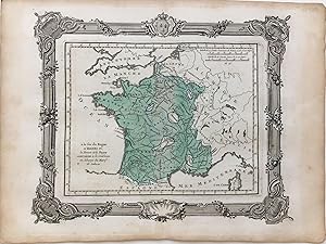
Carte de la reunion de la Navarre, Bearn, Armagnac, Foix, Albret, Bigorre, Vendome, Perigord, et du Comte de Limoges a la Couronne de France sous Henri IV
Verlag: Bourdeaux, 1764
Anbieter: Argosy Book Store, ABAA, ILAB, New York, NY, USA
Bewertung:
unbound. Zustand: very good. Map. Hand colored engraving, uncolored cartouche. Image measures 10 x 11 1/2". This map of France offers ample detail about the French kingdom during the reign of Henri IV. It is meant to represent the reunification of the provinces listed in the title. It extends from the Atlantic Ocean and the southern border of England to the western border of Germany, and the Mediterranean sea. Published in 1764, the map is labeled with rivers, cities, and lakes, and forests are depicted pictorially. An appropriately uncolored title cartouche in the lower left is decorated with flowers. It is in excellent condition with no chips or tears. Giovanni Antonio Bartolomeo Rizzi Zannoni (1736--1814), an Italian cartographer active in Venice and Naples, was one of the leading cartographers of the 18th century. He is admired for his careful and precise work, which responded to the growing demand in this period for accuracy and detail.
-
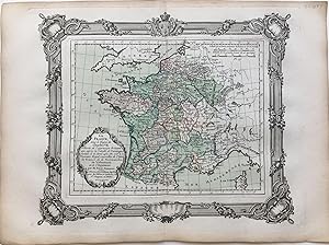
a la fin du Regne d'Henri IV; la Bresse et le Bugey sont reunis a la Couronne en echange du Marqt de Saluces
Verlag: Bourdeaux, 1764
Anbieter: Argosy Book Store, ABAA, ILAB, New York, NY, USA
Bewertung:
unbound. Zustand: very good. Map. Hand colored engraving. Image measures 9 3/4 x 12". This map of France offers ample detail about the French kingdom at the end of the reign of Henri IV. It extends from the Atlantic Ocean and the southern border of England to the western border of Germany, and the Mediterranean sea. Published in 1764, the map is labeled with rivers, cities, and lakes. It is in excellent condition with no chips or tears. Giovanni Antonio Bartolomeo Rizzi Zannoni (1736--1814), an Italian cartographer active in Venice and Naples, was one of the leading cartographers of the 18th century. He is admired for his careful and precise work, which responded to the growing demand in this period for accuracy and detail.
-
La France
Verlag: Bourdeaux, 1764
Anbieter: Argosy Book Store, ABAA, ILAB, New York, NY, USA
Bewertung:
unbound. Zustand: very good. Map. Hand colored engraving, uncolored cartouche. Image measures 10 x 11 1/2". This map of France offers ample detail about the French kingdom during the reign of Charles VII. It extends from the Atlantic Ocean and the southern border of England to the western border of Germany, and the Mediterranean sea. Published in 1764, the map is labeled with rivers, cities, and lakes, and forests are depicted pictorially. An appropriately uncolored title cartouche in the lower left is decorated with flowers. It is in excellent condition with no chips or tears. Giovanni Antonio Bartolomeo Rizzi Zannoni (1736--1814), an Italian cartographer active in Venice and Naples, was one of the leading cartographers of the 18th century. He is admired for his careful and precise work, which responded to the growing demand in this period for accuracy and detail.
-
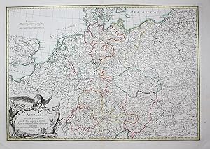
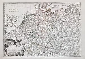
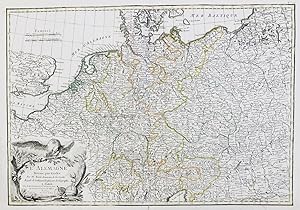
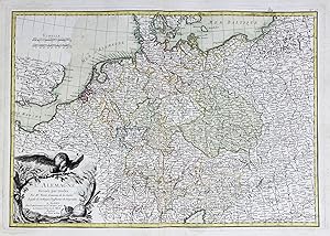
L'Alemagne
Verlag: Lattre, Bordeaux, 1783
Anbieter: Argosy Book Store, ABAA, ILAB, New York, NY, USA
Bewertung:
unbound. Map. Hand colored engraving, uncolored cartouche. Image measures 10 x 11 1/2". This highly detailed map of Germany extends to include present-day Belgium, Netherlands, and parts of Poland. Cities, rivers, lakes, and regions are labeled. Published circa 1783, the map depicts Prussia's territorial gains after the First Partition of Poland. An appropriately uncolored title cartouche in the lower left features an eagle and regalia. Giovanni Antonio Bartolomeo Rizzi Zannoni (1736--1814), an Italian cartographer active in Venice and Naples, was one of the leading cartographers of the 18th century. He is admired for his careful and precise work, which responded to the growing demand in this period for accuracy and detail.