
Gesamtpreis (1 Artikel Artikel):
Versandziel:

MERCATOR, GERARDUS (180 Ergebnisse)
Direkt zu den wichtigsten Suchergebnissen
Produktart
- Alle Produktarten
- Bücher (129)
- Magazine & Zeitschriften
- Comics
- Noten
- Kunst, Grafik & Poster
- Fotografien (1)
- Karten (50)
-
Manuskripte &
Papierantiquitäten
Zustand
- Alle
- Neu
- Antiquarisch/Gebraucht
Einband
Weitere Eigenschaften
- Erstausgabe (15)
- Signiert
- Schutzumschlag
- Angebotsfoto (174)
Land des Verkäufers
Verkäuferbewertung
-

Literarum Latinarum, Quas Italicas, Cursoriasque Vocant Scribendarum Ratio (Penman's Paradise) (Latin Edition)
Verlag: Brill - Hes & de Graaf, 1970
Paperback. Zustand: Fine. Covered with plastic.
-
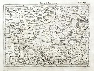
Burgundia Comitatus
Verlag: Hondius, Jodocus - Claesz., Cornelis and Jansz., Jan, Amsterdam, 1608
"Burgundia Comitatus". Orig. copperplate engraving from G. Mercator's Atlas Minor. Published by J. Hondius, C. Claesz. and J. Jansz. in Amsterdam, 1608. With ornamental title-cartouche, another cartouche with the scale of map ("Milliaria Burgundiae") and French title ("Le Comte de Bourgogne") above the map. 13,5:18,5 cm (5 1/4 x 7 1/4 inch.). Koeman III, map 4880:351, ed. 351:11 (1608 Atlas Minor [Fr.]). - A miniature map of the eastern part of the French region of Bourgogne-Franche-Comte (BFC). Oriented to the West.
-
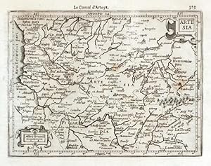
Artesia
Verlag: Hondius, Jodocus - Claesz., Cornelis and Jansz., Jan, Amsterdam, 1608
"Artesia". Orig. copperplate engraving from G. Mercator's Atlas Minor. Published by J. Hondius, C. Claesz. and J. Jansz. in Amsterdam, 1608. With ornamental title-cartouche, another cartouche with the scale of map ("Miliaria Germanica") and French title ("Le Comte d'Artoys") above the map. 13,5:18 cm (5 1/4 x 7 inch.). Koeman III, map 330:351, ed. 351:11 (1608 Atlas Minor [Fr.]). - A miniature map of Artois, a region of northern France.
-
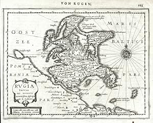
Rugia Insula Ac Ducatus accuratissime descripta
Verlag: Joan Janssonius, Amsterdam, 1648
Karte
Kein Einband. Zustand: Gut bis sehr gut. Rügen. "Rugia Insula Ac Ducatus accuratissime descripta". Orig. Kupferstich Karte nach E. Lubin aus Mercators Atlasu Minor. Bei J. Janssonius in Amsterdam, 1648. Mit ornament. Titelkart. mit Meillenanzeiger und dt. Titel ('Von Rugen') über die Karte. 15,5:20,5 cm. Koeman III, map 2192:352.1, ed. 352:32/33 (1648-51 German). - Karte von Rügen. - Linker Rand knapp beschnitten (außerhalb des Druckbereichs).
-
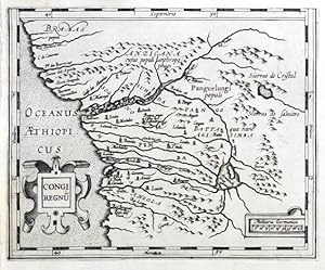
Congi Regnum
Verlag: Hondius, Jodocus, Amsterdam, 1607
Congo (Western Africa). "Congi Regnum". Orig. copperplate engraving from G. Mercator's Atlas Minor. Published in Amsterdam by J. Hondius, C. Claesz. and J, Jansz., 1607. With ornamental title-cartouche and another ornamental cartouche with the scale of map. 14:17,5 cm (5 1/2 x 7 inch.). Norwich 319a; Koeman III, map 8755:351, ed. 351:01 (1607 Atlas Minor). - A decorative miniature map of the western part of Africa (today Gabon, Congo, Zaire, Angola) with depiction of Congo river basin.
-
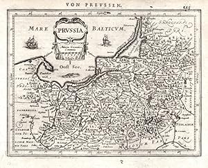
Prussia
Verlag: Janssonius, Amsterdam, 1648
Karte
Kein Einband. Zustand: Sehr gut. Prussia. "Prussia". Orig. copperplate engraving after G. Mercator's map of the region. Published by J. Janssonius in Amsterdam, 1648-51. With ornamental title-cartouche, German title above the map and 2 ships in the Baltic sea. 14,5:19 cm (5 3/4 x 7 1/2 inch.). Koeman III, map 1720:352.1, ed. 352:32/33 (1648-51 German) - A map of northeast part of Poland and part of Russia (Kaliningrad Oblast).
-
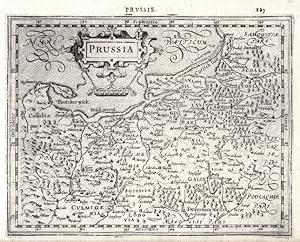
Prussia
Verlag: Hondius, Amsterdam, 1608
Karte
Kein Einband. Zustand: Sehr gut. Prussia. "Prussia". Orig. copperplate engraving after G. Mercator's map of the region. Published by J. Hondius in Amsterdam, 1608. With ornamental title-cartouche, French title above the map ("Prvssie.") and "Miliaria Germanica Co:". 15:19,5 cm (6 x 7 3/4 inch.). Koeman III, map 1720:351, ed. 351:11 (1608 Atlas Minor [Fr.]). - A map of northeast part of Poland and part of Russia (Kaliningrad Oblast).
-
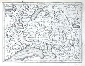
Das Wiflispurgergou
Verlag: Hondius, Jodocus, Amsterdam, 1607
"Das Wiflispurgergou". Orig. copperplate engraving from Mercator's Atlas minor. Published by J. Hondius, 1607. With ornamental title cartouche. 14:18,5 cm (5 1/2 x 7 1/4 inch.). Koeman III, map 4920:351, ed. 351:01 (1607 Atlas Minor). - A miniature map of the Canton of Vaud.
-
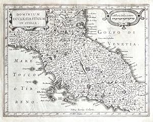
Dominium Ecclesiasticum in Italia
Verlag: Janssonius, Johannes, Amsterdam, 1648
Papal States. "Dominium Ecclesiasticum in Italia". Orig. copperplate engraving from the German edition of Mercator's Atlas Minor published in Amsterdam by J. Janssonius, 1648. Engraved by P. Kaerius. With ornamental title-cartouche and another ornamental cartouche with the scale of map ("Milliaria Italica commu."). 15,5:20 cm (6 1/4 x 7 3/4 inch.). Koeman III, map 7300:352.1, ed. 352:32/33 (1648-51 German). - A decorative miniature map of the Papal States in Central Italy . - Margins expertly complemented with old paper.
-
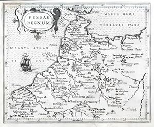
Fessae Regnum
Verlag: Hondius, Jodocus, Amsterdam, 1607
Morocco. "Fessae Regnum". Orig. copperplate engraving from G. Mercator's Atlas Minor. Published in Amsterdam by J. Hondius, C. Claesz. and J, Jansz., 1607. With ornamental title-cartouche and a ship. 15,5:19 cm (6 1/4 x 7 1/2 inch.). Koeman III, map 8616:351, ed. 351:01 (1607 Atlas Minor). - A decorative miniature map of the northern part of Morocco (Fes) and western part of Algeria.
-
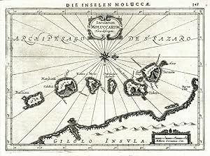
Insularum Moluccarum Nova descriptio
Verlag: Joan Janssonius, Amsterdam, 1648
Karte
Kein Einband. Zustand: Gut bis sehr gut. Moluccas. "Insularum Moluccarum Nova descriptio". Orig. copperplate engraving from Mercator's Atlas Minor. Published by J. Janssonius in Amsterdam, 1648. With ornamental title cartouche, a cartouche with the scale of map and German title above the map ('Die Inselen Molucae'). 14,5:20 cm (5 3/4 x 8 inch.). Koeman III, map 8560:352.1, ed. 352:32/33 (1648-51 German). - A miniature map of the Indonesian archipelago Moluccas. - Left margin trimmed (approx. 5 mm from the plate) and set with paper from the time.
-
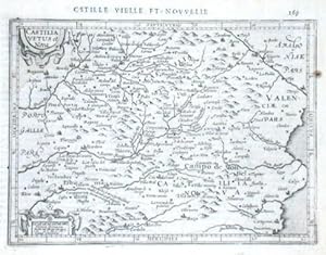
Castilia Vetus et Nova
Verlag: Hondius, Jodocus, Amsterdam, 1609
"Castilia Vetus et Nova". Orig. copperplate engraving from Meractor's Atlas Minor published by J. Hondius (with C. Claessius and J. Janssonius) in Amsterdam, 1609. With ornamental title-cartouche, another ornament. cartouche with "Miliaria Germanica. Lucae Hispanicae" and engraved French title above the map ("C(a)stille vielle et novvelle"). 14:19 cm (5 1/2 x 7 1/2 inch.). Koeman III, map 6055:351, ed. 351:11 (1609 Atlas Minor, French ed.) - Map of central part of Spain with the citeies of Valadolid, Zaragoza, Madrid, Toledo, Merida, Badajos . and many others.
-
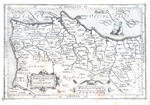
Portugallia olim Lusitania
Verlag: Hondius, Jodocus, Amsterdam, 1609
"Portugallia olim Lusitania". Orig. copperplate engraving from Meractor's Atlas Minor published by J. Hondius (with C. Claessius and J. Janssonius) in Amsterdam, 1609. With ornamental title-cartouche, another ornament. cartouche with "Hispanicae leucae 17 1/2 uni gradui Competentia. Miliaria Germanica qudum 15 ui gradi respodet" and a boy riding on a sea-creature. 13,5:20 cm. Koeman III, map 6300:351, ed. 351:21 (Atlas Minor [Ger.]) - West-oriented map of Portugal.
-
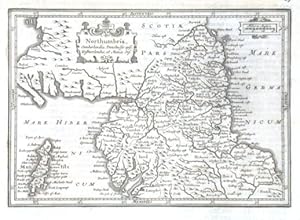
Northumbria, Cumberlandia, Dunelmensis episc. Westmorlandia, et Mania Ins.
Verlag: Janssonius, Johannes, Amsterdam, 1648
"Northumbria, Cumberlandia, Dunelmensis episc. Westmorlandia, et Mania Ins.". Orig. copperplate engraving from Mercator's Atlas Minor published in Amsterdam by J. Janssonius, 1648. With engraved German heading-title ("Von Engelandt"), ornamental title-cartouche and the scale of map ("Miliaria Anglica") in another cartouche. 15:19,5 cm (6 x 7 3/4 inch.). Koeman III, map 5300:352.1, ed. 352:32/33 (1648-51 German) - Map of North England with the Man island.
-
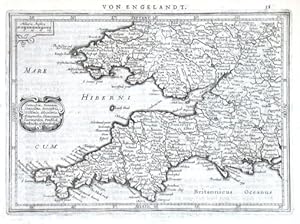
Cornubia, Devonia, Somersetus
Verlag: Janssonius, Johannes, Amsterdam, 1648
"Cornubia, Devonia, Somersetus, Dorcestria, Wiltonia, Glocestria, Monumentha, Glamorgan, Caermarden, Penbrok, Breknoke, et Herfordia". Orig. copperplate engraving from Mercator's Atlas Minor published in Amsterdam by J. Janssonius, 1648. With engraved German heading-title ("Von Engelandt"), ornamental title-cartouche and a scale of map ("Miliaria Anglica") in another ornamental cartouche. 14,5:20,5 cm (5 3/4 x 8 inch.). Koeman III, map 5112:352.1, ed. 352:32/33 (1648-51 German).
-
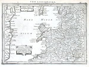
Lancastria, Cestria, Caernarvan
Verlag: Janssonius, Johannes, Amsterdam, 1648
"Lancastria, Cestria, Caernarvan, Denbich, Flint, Merionidh, Montgomery, Salopia, Cardigan, Radnor, Wigornia, et Ins. Anglesey". Orig. copperplate engraving from Mercator's Atlas Minor published in Amsterdam by J. Janssonius, 1648. With engraved German heading-title ("Von Engelandt"), ornamental title-cartouche and a scale of map ("Miliaria Anglica") in another ornamental cartouche. 14,5:20,5 cm (5 3/4 x 8 inch.). Koeman III, map 5111:352.1, ed. 352:32/33 (1648-51 German) - Map of northwestern England.
-
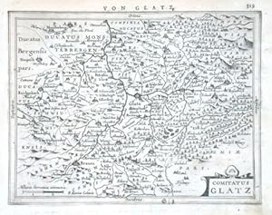
Comitatus Glatz
Verlag: Janssonius, Johannes, Amsterdam, 1648
"Comitatus Glatz". Orig. copperplate engraving after G. Mercator's map of the region, engraved by P. van den Keere (Kaerius), published by J. Janssonius in Amsterdam, 1648-51. With ornamental title-cartouche, the scale of map ("Milliaria Germanica communia") and engraved German heading-title ("Von Glatz."). 15,5:20,5 cm (6 x 8 inch.). Koeman III, map 2960:352.1, ed. 352:32/33 (1648-51 German) - Decorative map of the city of Klodzko with its environs. Oriented to the East.
-
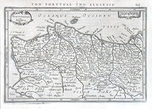
Portugallia et Algarve
Verlag: Janssonius, Johannes, Amsterdam, 1628
"Portugallia et Algarve". Orig. copperplate engraving after G. Mercator's map of the region. Published in Amsteradam by J. Janssonius, 1648. With ornamental title-cartouche, decorative cartouche with the scale of map ("Scala leucae Hispanicarum") and German heading title ("Von Portvgal vnd Algarbia"). 14:20,5 cm (5 3/4 x 8 1/4 inch.). Koeman III, map 6300:352.1, ed. 352:32/33 (1648-51 German) - A miniature map of Portugal. Oriented to the West.
-
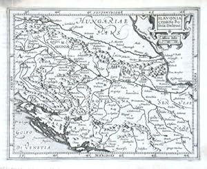
Slavonia Croatia Bosnia. Dalmat.
Verlag: Hondius, Jodocus, Amsterdam, 1607
"Slavonia Croatia Bosnia. Dalmat.". Orig. copperplate engraving from G. Mercator's Atlas Minor. Published in Amsterdam by J. Hondius, with C. Claesz. and Jan Jansz., 1607. With ornamental title-cartouche with the scale of map ("Milliaria Italica"). 14,5:18 cm (5 3/4 x 7 inch.). Koeman III, map 7601:351, ed. 351:01 (1607 Atlas Minor) - A miniature map of the western Balkan region.
-

Fionia
Verlag: Hondius, Jodocus, Amsterdam, 1608
"Fionia". Orig. copperplate engraving from the French edition of G. Mercator's Atlas Minor. Published in Amsterdam by J. Hondius with C. Claesz. and J. Jansz., 1608. With ornamental title-cartouche, another ornamental cartouche with the scale of map ("Milia. Germanica Comu:") and French title ("Danemarck") above the map. 13,5:18,5 cm (5 1/4 x 7 1/4 inch). Koeman III, map 1530:351, ed. 351:11 (1608 French). - A miniature map of the Danish island of Funen (Fyn).
-
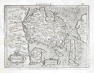
Fionia
Verlag: Hondius, Jodocus, Amsterdam, 1608
Funen (Denmark)."Fionia". Orig. copperplate engraving from the French edition of G. Mercator's Atlas Minor. Published in Amsterdam by J. Hondius with C. Claesz. and J. Jansz., 1608. With ornamental title-cartouche, another ornamental cartouche with the scale of map ("Milia. Germanica Comu:") and French title ("Danemarck") above the map. 13,5:18,5 cm (5 1/4 x 7 1/4 inch). Koeman III, map 1530:351, ed. 351:11 (1608 French). - A miniature map of the Danish island of Funen (Fyn).
-
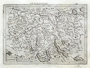
Zurichou
Verlag: Hondius, Jodocus - Claesz., Cornelis and Jansz., Jan, Amsterdam, 1608
"Zurichou". Orig. copperplate engraving from G. Mercator's Atlas Minor. Published by J. Hondius, C. Claesz. and J. Jansz. in Amsterdam, 1608. With ornamental title-cartouche, another cartouche with the scale of map ("Miliare Helveticum Com.") and French title ("De Zurichgow") above the map. 14:20 cm (5 1/2 x 8 inch.). Koeman III, map 4910:351, ed. 351:11 (1608 Atlas Minor [Fr.]). - A miniature map of the northern Switzerland centered on the city of Zürich.
-
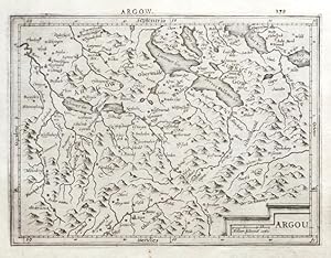
Argou
Verlag: Hondius, Jodocus - Claesz., Cornelis and Jansz., Jan, Amsterdam, 1608
"Argou". Orig. copperplate engraving from G. Mercator's Atlas Minor. Published by J. Hondius, C. Claesz. and J. Jansz. in Amsterdam, 1608. With ornamental title-cartouche with the scale of map ("Milliare Helveticu comu.") and French title ("Argow") above the map. 14,5:19,5 cm (5 3/4 x 7 3/4 inch.). Koeman III, map 4930:351, ed. 351:11 (1608 Atlas Minor [Fr.]). - A miniature map of the Canton of Aargau.
-
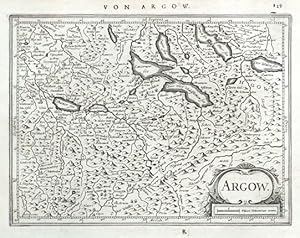
Argow
Verlag: Janssonius, Johannes, Amsterdam, 1648
"Argow". Orig. copperplate engraving from G. Mercator's Atlas Minor. Published by J. Janssonius in Amsterdam, 1648. With ornamental title-cartouche with the scale of map ("Miliare Helveticum comm.") and German title ("Von Argow") above the map. 14,5:19 cm (5 3/4 x 7 1/2 inch.). Koeman III, map 4930:352.1, ed. 352:32/33 (1648-51 German). - A miniature map of the Canton of Aargau.
-
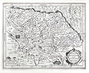
Marcha Anconitana cum Spoletano Ducatu
Verlag: Hondius, Jodocus - Claesz., Cornelis and Jansz., Jan, Amsterdam, 1607
"Marcha Anconitana cum Spoletano Ducatu". Orig. copperplate engraving from G. Mercator's Atlas Minor. Published by J. Hondius, C. Claesz. and J. Jansz. in Amsterdam, 1607. With ornamental title-cartouche and another cartouche with the scale of map ("Milliaria Italica"). 14,5:18 cm (5 3/4 x 7 inch.). Koeman III, map 7350:351, ed. 351:01 (1607 Atlas Minor). - A miniature map of Marche. With the city of Ancona at the top. - Upper margin cutted closely to the desk and expertly restored.
-
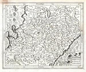
Abruzzo et Terra di Lovoro
Verlag: Hondius, Jodocus - Claesz., Cornelis and Jansz., Jan, Amsterdam, 1607
"Abruzzo et Terra di Lovoro". Orig. copperplate engraving from G. Mercator's Atlas Minor. Published by J. Hondius, C. Claesz. and J. Jansz. in Amsterdam, 1607. With ornamental title-cartouche with the scale of map ("Milliaria Italica"). 14,5:18 cm (5 3/4 x 7 inch.). Koeman III, map 7401:351, ed. 351:01 (1607 Atlas Minor). - A miniature map of Abruzzi and Campania.
-
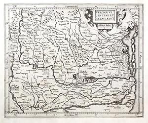
Veronae Vicentiae et Pataviae Dit.
Verlag: Hondius, Jodocus - Claesz., Cornelis and Jansz., Jan, Amsterdam, 1607
Verona, Vicenza and Padua. "Veronae Vicentiae et Pataviae Dit.". Orig. copperplate engraving from G. Mercator's Atlas Minor. Published by J. Hondius, C. Claesz. and J. Jansz. in Amsterdam, 1607. With ornamental title-cartouche with the scale of map ("Milliaria Italica"). 14,5:18 cm (5 3/4 x 7 inch.). Koeman III, map 7110:351, ed. 351:01 (1607 Atlas Minor). - A miniature map of the regions of the northeastern part of Italy.
-
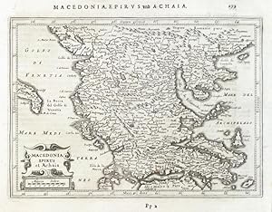
Macedonia, Epirus et Achaia
Verlag: Amsterdam, 1648
Greece, Abania and Macedonia. "Macedonia, Epirus et Achaia". Orig. copperplate engraving from the German ed. of Mercator's "Atlas Minor". Published in Amsterdam by J. Janssonius, 1648-52. With ornamental title-cartouche with the scale of map ("Miliaria Italica") and Ger. title ("Macedonia, Epirvs und Achaia") above the map. 14,5:20,5 cm (5 3/4 x 8 inch.). Koeman III, map 7830:352, ed. 352:32/33 (1648-51 German). - A miniature map of northern part of Greece, Macedonia and Albania.
-
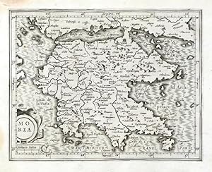
Morea
Verlag: Hondius, Jodocus - Claesz. Cornelis - Jansz. Jan, Amsterdam, 1607
"Morea". Orig. copperplate engraving from Mercator's "Atlas Minor". Published in Amsterdam by J. Hondius, C. Claesz. and J. Jansz., 1607. With ornamental title-cartouche with the scale of map ("Milliaria Italica"). 13,5:17,5 cm (5 1/4 x 7 inch.). Koeman III, map 7820:351, ed. 351:01 (1607 Atlas Minor). - A miniature map of the Greek peninsula Peloponnese (Peloponnesus or Peloponnisos).
-
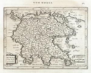
Morea olim Peloponensis
Verlag: Amsterdam, 1648
"Morea olim Peloponensis". Orig. copperplate engraving from the German ed. of Mercator's "Atlas Minor". Published in Amsterdam by J. Janssonius, 1648-52. Engraved by P. Kaerius (van den Keere). With ornamental title-cartouche, another cartouche with the scale of map ("Milliaria Italica") and Ger. title ("Von Morea") above the map. 14:19 cm (5 1/2 x 7 1/2 inch.). Koeman III, map 7820:352.1, ed. 352:32/33 (1648-51 German). - A miniature map of the Greek peninsula Peloponnese (Peloponnesus or Peloponnisos).
