Gesamtpreis (1 Artikel Artikel):
Versandziel:

MENTELLE, EDME (120 Ergebnisse)
Direkt zu den wichtigsten Suchergebnissen
Produktart
- Alle Produktarten
- Bücher (47)
- Magazine & Zeitschriften
- Comics
- Noten
- Kunst, Grafik & Poster (1)
- Fotografien
- Karten (72)
-
Manuskripte &
Papierantiquitäten
Zustand
Einband
Weitere Eigenschaften
- Erstausgabe (7)
- Signiert (1)
- Schutzumschlag
- Angebotsfoto (105)
Gratisversand
Land des Verkäufers
Verkäuferbewertung
-

Géographie comparée; ou Analyse de la Géographie ancienne et moderne des peuples de tous les pays et de tous les âges. Géographie astronomique.
Verlag: Paris, l'Auteur, Nyon., 1781
Anbieter: Manfred Nosbuesch, Kuchenheim, Deutschland
Bewertung:

(4), 236pp. Orig. publisher's wrappers with printed label to front cover. Uncut. - Printed on thick paper. - Text block partly broken, paper covering spine partly missing, else very good.
-
Géographie comparée; ou Analyse de la Géographie ancienne et moderne des peuples de tous les pays et de tous les âges. Portugal moderne.
Verlag: Paris, l'Auteur, Nyon., 1784
Anbieter: Manfred Nosbuesch, Kuchenheim, Deutschland
Bewertung:
XXIV, 270pp. Orig. publisher's wrappers with printed label to front cover. No maps present. - Uncut. - Printed on thick paper. - Text block partly broken, paper covering spine partly missing, wrappers and margins of first few pages partly soiled, else very good.
-
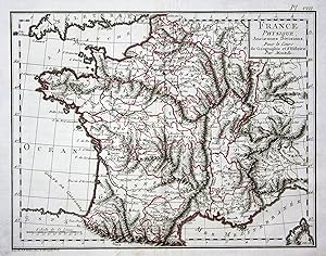
France Physique. Anciennes Divisions" - France Frankreich Paris Lyon Europe Europa Karte map Mentelle
Verlag: Paris, 1800
Anbieter: Antiquariat Steffen Völkel GmbH, Seubersdorf, Deutschland
Bewertung:

Karte
original handkolorierte Kupferstich-Karte von ca. 1800 - Blatt-Maße: ca. 39 x 25 cm - gut erhalten -- original handcolored engraved map from circa 1800 - good condition | Dies ist ein Original! - Kein Nachdruck! - Keine Kopie! -- This is an original! No copy! - No reprint! Sprache: Französisch Gewicht in Gramm: 1550.
-
Géographie comparée; ou Analyse de la Géographie ancienne et moderne des peuples de tous les pays et de tous les âges. Italie ancienne.
Verlag: Paris, l'Auteur, Nyon., 1779
Anbieter: Manfred Nosbuesch, Kuchenheim, Deutschland
Bewertung:
VIII, 346pp. Orig. publisher's wrappers with printed label to front cover. No maps present. - Uncut. - Printed on thick paper. - Text block partly broken, paper covering spine partly missing, else very good.
-
Géographie comparée; ou Analyse de la Géographie ancienne et moderne des peuples de tous les pays et de tous les âges. Italie moderne.
Verlag: Paris, l'Auteur, Nyon., 1780
Anbieter: Manfred Nosbuesch, Kuchenheim, Deutschland
Bewertung:
XXXII, 468pp. Orig. publisher's wrappers with printed label to front cover. No maps present. - Uncut. - Printed on thick paper. - Text block partly broken, paper covering spine partly missing, else very good.
-
Géographie comparée; ou Analyse de la Géographie ancienne et moderne des peuples de tous les pays et de tous les âges. Turquie d'Europe.
Verlag: Paris, l'Auteur, Nyon., 1779
Anbieter: Manfred Nosbuesch, Kuchenheim, Deutschland
Bewertung:
(4), VIII, 183pp. Orig. publisher's wrappers with printed label to front cover. No maps present. - Uncut. - Printed on thick paper. - Text block partly broken, paper covering spine partly missing, else very good.
-
Géographie comparée; ou Analyse de la Géographie ancienne et moderne des peuples de tous les pays et de tous les âges. Espagne ancienne.
Verlag: Paris, l'Auteur, Nyon., 1781
Anbieter: Manfred Nosbuesch, Kuchenheim, Deutschland
Bewertung:
XVI, 388pp. Orig. publisher's wrappers with printed label to front cover. No maps present. - Uncut. - Printed on thick paper. - Text block partly broken, paper covering spine partly missing, else very good.
-
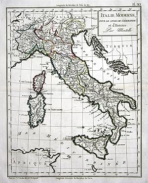
Italie Moderne" - Italia Italien Sicilia Sizilien Sardinia Sardinien Europa Europe Karte map Mentelle
Verlag: Paris, 1800
Anbieter: Antiquariat Steffen Völkel GmbH, Seubersdorf, Deutschland
Bewertung:
Karte
original handkolorierte Kupferstich-Karte von ca. 1800 - Blatt-Maße: ca. 25 x 39 cm - gut erhalten -- original handcolored engraved map from circa 1800 - good condition | Dies ist ein Original! - Kein Nachdruck! - Keine Kopie! -- This is an original! No copy! - No reprint! Sprache: Französisch Gewicht in Gramm: 1550.
-
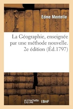
La Geographie, Enseignee Par Une Methode Nouvelle. 2e Edition
Verlag: HACHETTE LIVRE, 2020
ISBN 10: 2329395450ISBN 13: 9782329395456
Buch
Zustand: New.
-
Le Porte-Feuille Du R.F. Gillet, Ci-Devant Soi-Disant Jésuite: Ou Petit Dictionnaire, Dans Lequel On N\ A Mis Que Des Choses Essentielles, Pour Servir
Verlag: WENTWORTH PR, 2018
ISBN 10: 0270204563ISBN 13: 9780270204568
Buch
Kartoniert / Broschiert. Zustand: New.
-
Zustand: New.
-

Géographie Abrégée De La Grčce Ancienne.
Verlag: WENTWORTH PR, 2018
ISBN 10: 0341294373ISBN 13: 9780341294375
Buch
Gebunden. Zustand: New.
-
Choix de Lectures Geographiques Et Historiques. Tome 6
Verlag: HACHETTE LIVRE, 2021
ISBN 10: 2329615213ISBN 13: 9782329615219
Buch
Zustand: New.
-

Choix de Lectures Geographiques Et Historiques. Tome 2
Verlag: HACHETTE LIVRE, 2021
ISBN 10: 2329615221ISBN 13: 9782329615226
Buch
Zustand: New.
-

Choix de Lectures Geographiques Et Historiques. Tome 4
Verlag: HACHETTE LIVRE, 2021
ISBN 10: 2329615205ISBN 13: 9782329615202
Buch
Zustand: New.
-
Choix de Lectures Geographiques Et Historiquues. Tome 5
Verlag: HACHETTE LIVRE, 2021
ISBN 10: 2329615248ISBN 13: 9782329615240
Buch
Zustand: New.
-

Le Porte-Feuille Du R.F. Gillet, Ci-Devant Soi-Disant Jésuite: Ou Petit Dictionnaire, Dans Lequel On N\ A Mis Que Des Choses Essentielles, Pour Servir
Verlag: WENTWORTH PR, 2018
ISBN 10: 0270204571ISBN 13: 9780270204575
Buch
Gebunden. Zustand: New.
-

Choix de Lectures Geographiques Et Historiques. Tome 3
Verlag: HACHETTE LIVRE, 2021
ISBN 10: 2329615191ISBN 13: 9782329615196
Buch
Zustand: New.
-
Encyclopédie Méthodique: Géographie Ancienne Volume 1
Verlag: WENTWORTH PR, 2018
ISBN 10: 0274890151ISBN 13: 9780274890156
Buch
Kartoniert / Broschiert. Zustand: New.
-
Paris, Bernard, 1804, 4 tomes en 4 vol. in 8, rel. d'ép. dos lisses veau vert olive, dos ornés de motifs ŕ froid et quadruples filets dorés, bon ex. L'atlas de 20 cartes manque.
-
Astronomische Erdbeschreibung. Aus dem Französischen übersetzt und mit einigen Anmerkungen versehen [von Johann Georg Müller].
Verlag: Winterthur: Heinrich Steiner und Compagnie,, 1785
Buch Erstausgabe
8°. VII,(5),239,(1) S. Mit 6 (2 gestochenen) Falt-Tabellen und 8 gestochenen Falt-Tafeln. Erste deutsche Ausgabe. - Die vergleichende Erdbeschreibung; oder System der alten und neuen Erdbeschreibung aller Völker und Zeiten: Erster Band [von 7]. - Fromm 17310. - Die gestochenen Tafeln und Tabellen von Jakob Joseph Clausner (1744-1797) aus Zug. - Gering berieben; Namen am Titelblatt; vorderer fliegender Vorsatz entfernt; ohne Seite 1/2 der Einleitung, ansonsten ordentliches Exemplar. Sprache: Deutsch Gewicht in Gramm: 550 Halblederband der Zeit mit Rückenvergodung und goldgeprägten Rückenschildchen. Farbschnitt.
-
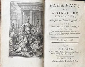
Eléments de l'histoire romaine, divisés en deux parties: Avec des cartes et un tableau analytique. Mit gestoch. Frontispiz, 1 gefalt. Taf., 3 Plänen und 3 gefalt. gest. Karten.
Verlag: Paris, Delalain, 1766
Anbieter: Treptower Buecherkabinett Inh. Schultz Volha, Berlin, Deutschland
Bewertung:
Buch
Kl.-8°. LII, 494 Seiten, 2 Bll. HLdr. d. Zt. (etwas beschabt, teils tintenfleckig). Teils etwas tintenfleckig, 2 Bll. dadurch mit kleiner Fehlstelle, hinterer Innendeckel u. letztes Bll. stärker betroffen, insgesamt aber noch ordentlich mit allen Karten und Plänen. PA2-102 Sprache: Deutsch Gewicht in Gramm: 2000.
-
Cours Complet De Cosmographie, De Géographie, De Chronologie, Histoire Ancienne Et Moderne.
Verlag: WENTWORTH PR, 2019
ISBN 10: 035381038XISBN 13: 9780353810389
Buch
Gebunden. Zustand: New.
-

Considérations générales sur l'instruction publique. Mémoire lu ŕ la classe des Sciences morales et politiques de l'Institut national, le dix-sept Fructidor de l'an V.
Erstausgabe
Paris, chez l'auteur et Desenne, an VI [1797]. In-8, broché, couverture de papier moderne, tranches rouges, 27 p. Edition originale. Géographe et historien, Edme Mentelle (1730-1815) était professeur de géographie et d'histoire ŕ l'Ecole militaire. Aprčs la suppression de cet établissement en 1792, il fut successivement professeur de géographie ŕ l'Ecole centrale et, en 1794, ŕ l'Ecole normale. Il devint, en 1760, professeur et membre de l'Institut dčs sa création. Il soumet, dans cet essai, un manifeste pour une instruction publique laďque et citoyenne ("morale"). Un post-scriptum est consacré ŕ la "Nécessité d'une chaire de géographie physique et politique dans les Ecoles centrales". (Buisson, I, I, p. 208. Martin & Walter, III, 23853. Monglond, IV, 133). Légčrement débroché. Trčs bon exemplaire, trčs frais.
-
Éléments de l`Histoire Romaine, Divisés en deux parties. Avec des carts & un tableau analytique.
Verlag: Paris, Delalain 1766., 1766
LII, 494 S., 3 Bll. Mit gest. Frontisp. v. Massard, 1 gefalt. Tab., 6 Karten u, Pläne auf 2 mehrf. gefalt. Taf. Pbd. d. Zt. Rü. stärker berieb. Taf. m. Wasserrand. Letzte Lage verbunden. EA Barbier IV (Suppl.) 52 f. Gewicht in Gramm: 500.
-
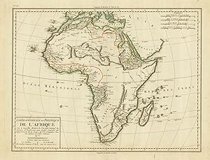
Carte Générale et Politique de l'Afrique.
Erscheinungsdatum: 1797
Anbieter: Altea Antique Maps, London, Vereinigtes Königreich
Verbandsmitglied: ABA ILAB PBFA
Bewertung:
Karte
Paris: Chanlaire & Mentelle, 1797. Original outline colour. 350 x 460mm. A map of the continent of Africa published in "An VI" of the French Republic. Of interest are the numerous mountain ranges criss-crossing the interior, including the infamous 'Mountains of Kong'.
-
A Paris, chez Nic. Aug. Delalain 1766. 12mo (16 x 9,5 cm). LII, 494 S., 1 Bl.; 2 Bl. Verlagsanzeigen. - Mit einem allegorischen gestochenen Frontispiz von Massard nach Bornet, einer gefalteten Tabelle und zwei gefalteten Kupfertafeln mit drei Karten und drei Plänen. - Marmoriertes Kalbsleder mit rotem Rückenschild und floraler Rückenvergoldung, Stehkantenfilete, Marmorpapiervorsätze, Rotschnitt. - Conlon 66:1199. Erste Ausgabe. - Eine Ecke beschädigt, das hintere Vorsatzblatt mit Randausriß; die Tabelle mit kleinem Loch und lose beiliegendem Eckabriß (kein Textverlust), ansonsten schönes Exemplar, hübsch gebunden.
-
Anfangsgründe der Weltbeschreibung oder Astronomie worinnen die nützlichsten Wahrheiten der himmlischen Naturlehre so deutlich vorgetragen werden, daß sie auch diejenigen begreifen können, die nicht den mindesten Begriff aus der Größenlehre besitzen. Aus der 2. Pariser Ausgabe ins Deutsche übersetzt und vermehrt mit einer Beschreibung der künstlichen Himmelkugel, nebst vielen Aufgaben, die sehr nützlich sind, von Georg Friedrich Kordenbusch. 2 Teile (in 1 Bd.). Nürnberg, Weigel & Schneider 1788-89. 3 gefalt. Tafeln. 8 Bl., 172; S. 173-289, 1 Bl. Moderner marmorierter Pppbd. mit Rückenschild und vergold. Rückentitel. Houzeau & L., 8061; Poggend. I, 1306.- Vorsatz und Titel des ersten Teiles leicht gebräunt, ansonsten gut erhaltenes, frisches Exemplar.
-
Choix de lectures geographiques et historiques, presentees dans l'ordre qui a paru le plus propre a faciliter l'etude de la geographie de l'Asie, de l'Afrique et de l'Amerique. Precede d'un abrege de geographie, avec des cartes. Dedie a Madame la Comtesse de B***.
Verlag: Paris, Chez l'Auteur, Hotel de Mayence., 1783
Anbieter: Antiquariat Cassel & Lampe Gbr - Metropolis Books Berlin, Berlin, D, Deutschland
Bewertung:
Tome premier. VI, 172, XXIV, 235 Seiten und 6 kolorierte, mehrfach gefaltete Karten, 31 x 24 cm (Mappe monde, l'Europe, Asie, Afrique, Amerique septentrionale, Amerique meridionale). Privater Halbleinenband. Buchblock gelockert. Teil 2 enthält: Turquie et Arabie, des langues arabe, persane et turque. - Eine Karte mit hinterlegtem Einriß im Falz, zwei Seiten etwas fleckig sonst, besonders die Karten innen sehr schön. Sprache: Französisch.
-
Cosmographie élémentaire, divisée en Parties astronomiques et géographique. Ouvrage dans lequel on a tâche de mettre les vérités les plus intéressantes de la Physique céleste a la portée de ceux męme qui n'ont aucune notion de Mathématiques" Troisie.
Paris, Théophile Barrois, An VII (1799). 8vo. Bound in 2 well-preserved contemporary hcalf. Gilt backs. Title-and tomelabels in leather. XXII,727 pp., 1 folded table and 14 folded engraved plates (numb. I-XIII, 1 unnumb.), including 10 large folded and outline coloured engraved maps. Clean and fine, printed on good paper. With bookplate from "Nörager Bibliothek". Mentelle was geographer and historian, member of the Royal Inst. of Sciences and known for editing several geographical atlasses from 1782 up to 1808. - Poggendorff II:120.