Gesamtpreis (1 Artikel Artikel):
Versandziel:

MENTELLE, E , (14 Ergebnisse)
Direkt zu den wichtigsten Suchergebnissen
Produktart
- Alle Produktarten
- Bücher (12)
- Magazine & Zeitschriften
- Comics
- Noten
- Kunst, Grafik & Poster
- Fotografien
- Karten (2)
-
Manuskripte &
Papierantiquitäten
Zustand
Einband
- alle Einbände
- Hardcover
- Softcover (2)
Weitere Eigenschaften
- Erstausgabe (1)
- Signiert
- Schutzumschlag
- Angebotsfoto (11)
Land des Verkäufers
Verkäuferbewertung
-

Geografia e cronologia antica e moderna. In continuazione al Compendio della storia universale del sig. Conte di Segur coi nessi o legami storici che congiungono le storie separate coll'intero corpo di essa storia universale. Tom. XII ed ultimo. Parte seconda moderna. America.
Erscheinungsdatum: 1827
Anbieter: Libreria Piani, Monte San Pietro, BO, Italien
Bewertung:

Buch
Milano, Stella, 1827, 16mo brossura senza copertine, pp. 211 con illustrazioni xilografiche f.t. di cui una in antiporta (parzialmente intonso).
-
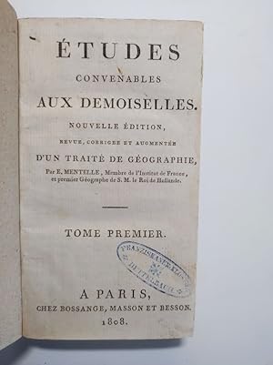
Études convenables aux demoiselles. Tome premier.
Verlag: Paris: Bossange, Masson et Besson, 1808
Buch
8° , Pp. [1] Bl., S. V - XII, 465 S. Bd. 1 apart, offb. fehlen die ersten 2 num. Seiten. Dekorativer Pp.-Bd. d. Zt. Gepfleger Zustand. Mit Stempel und Rückensignatur einer aufgelösten Klosterbibliothek. atx Philol233 Sprache: Französisch Gewicht in Gramm: 530.
-
Géographie comparée; ou Analyse de la Géographie ancienne et moderne des peuples de tous les pays et de tous les ages. Italie ancienne.
Verlag: Paris, 1779
VIII, 346 S. Br. d. Zt. Umschl. etwas läd. Gebräunt, teils braunfl. Unbeschnitten. Ohne die Tafeln! Sprache: Französisch.
-
![Bild des Verkäufers für Encyclopedie Methodique. Geographie Ancienne. T. 1, [Aar-Graes Gonu] (Ed.1787-1796) zum Verkauf von moluna](https://pictures.abebooks.com/inventory/md/md31545556381.jpg)
Encyclopedie Methodique. Geographie Ancienne. T. 1, [Aar-Graes Gonu] (Ed.1787-1796)
Verlag: HACHETTE LIVRE, 2012
ISBN 10: 2012659632ISBN 13: 9782012659636
Buch
Zustand: New. KlappentextEncyclopedie methodique. Geographie ancienne. T. 3, [Romanum imperium-Zyrma] /, par M. Mentelle, historiographe de monseigneur comte d Artois, censeur royal, de l Academie d histoire de Madrid, de celle de Rouen, &c. Tome prem.
-
![Bild des Verkäufers für Encyclopedie Methodique. Geographie Ancienne. T. 2, [Graeci-Roma] (Ed.1787-1796) zum Verkauf von moluna](https://pictures.abebooks.com/inventory/md/md31580797619.jpg)
Encyclopedie Methodique. Geographie Ancienne. T. 2, [Graeci-Roma] (Ed.1787-1796)
Verlag: HACHETTE LIVRE, 2012
ISBN 10: 2012542239ISBN 13: 9782012542235
Buch
Zustand: New.
-
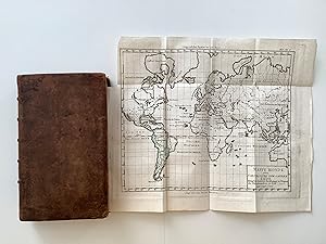
Die vergleichende Erdbeschreibung oder System der alten und neuen Erdbeschreibung aller Völker und Zeiten. Volume VI: NEU SPANIEN. Se trata solamente de Espańa
Verlag: Winterthur, Steiner., 1791
Erstausgabe
Volume VI (de VII) 21 : 12,5 cm. XIV, 642 páginas Con 6 (4 coloreados) mapas grabades y plegadas. Piel de época, lomo abundantemente dorado, 2 tejuelos. Detallado descripción de las provincias de Espańa. Primera edición en Aleman. Con un mapa del mundo, mapas de Espańa (2) y Portugal, la Bahia de Cadiz y la Sierra Morena.
-
![Bild des Verkäufers für Map of La France Comparative en Departements avec les anciennes division du territoire qu'elle comprend aujourd'huy [ beleived to be taken from Atlas Elementaire de Geogrphie Physique et Politique Ancienne et Moderne. ] zum Verkauf von Keoghs Books](https://pictures.abebooks.com/inventory/md/md510761522.jpg)
Map of La France Comparative en Departements avec les anciennes division du territoire qu'elle comprend aujourd'huy [ beleived to be taken from Atlas Elementaire de Geogrphie Physique et Politique Ancienne et Moderne. ]
Verlag: Published by J.B. Delaval & Madame V.Mentelle, Paris, 1818
Karte
, 40 x 51.5 cm engraved map with contemporary hand colouring, engraved area 32 x 41.5 cm, double page plate on guard mount numbered 22, text in French , central fold with small marginal tear at top, edges rubbed with small tears, map undamaged, very good condition 40 x 51.5 cm Map ISBN:
-
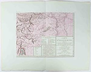
Carte D'Allemagne, Indiquant La Division Actuelle de cet Empire; Ainsi que les nouvelles Possessions des Princes qui composent le Corps Germanique. Et Batavie et L'Helvetie Avec leurs Nouvelles Divisions Map of Germany.
Erscheinungsdatum: 1805
Anbieter: Asia Bookroom ANZAAB/ILAB, Canberra, ACT, Australien
Bewertung:
Copper engraving with handcolouring, map shows the border of the Austrian Empire and Hungary, Vienne (sic) and the Danube can be seen at the top of the map, Two keys and scale inset. Few closed tears and some browning edges, otherwise a clean and bright image. Map measures approximately 34 x 44cm. Map of Germany indicating the present division of this empire as well as the new possessions of the princes who make up the Germanic body and including Batavia and Helvetia (Switzerland) with their divisions. by E. Mentelle, a member of the institute, and P. G. Chanlaire, one of the authors of the National Atlas. An xiii 1805. Paris. There is a key to the explanation of the signs and an explanation of the colours used for the district of the various states contained in this map.
-
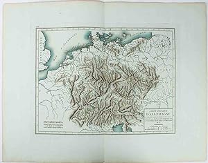
Carte Physique D'Allemagne.
Verlag: (c1800.), 1800
Anbieter: Asia Bookroom ANZAAB/ILAB, Canberra, ACT, Australien
Bewertung:
Copper engraving with handcolouring, map shows Germany and parts of France, Italie, Hongrie, Pologne and Prusse (sic). Minor hole upper border, few closed tears and some browning edges, otherwise a clean and bright image. Map measures approximately 34 x 46cm.
-

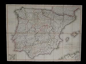
CARTE D'ESPAGNE ET DE PORTUGAL EN NEUF FEUILLES. PAR. REVUE ET AUGMENTÉE EN 1810
Verlag: Chez les auteurs, PARIS, 1810
Anbieter: Libreria Ripoll, Palma de Mallorca, BALEA, Spanien
Bewertung:
Estuche con tejuelo. Mapa de Espańa y Portugal, cuarteado y entelado en nueve partes, con buen color de época. El total del mapa tiene un tamańo de 104 x 136 cm.
-
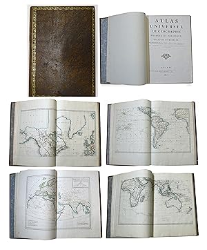
Atlas universel de géographie physique et politique, ancienne et moderne.
Verlag: Paris chez les auteurs, 1807
Anbieter: Antiquariat Clemens Paulusch GmbH, Berlin, Deutschland
Bewertung:
Buch
1 Bl., 3 SS. mit 31 (v. 178) teils grenzkol. doppelbl.- gr. Kst.- Karten, folio, marm. GLdr.- Bd. d. Zt. m. 2 farb. Rsch., Deckel- u. Rvg. ( l. besch. u. best. ). Phillips 712; Monglond VII, 696 ff. - Mit 1 Karte der Alten Welt, Weltkarte in 4 Blättern, Römisches Reich in 2 Blättern sowie 24 Europa - Karten, wobei Frankreich in 4 Blättern und Deutschland in 9 Blättern vorliegen. - Die Karten in sehr guter Erhaltung. - Individuelle Zusammenstellung in dekorativer Bindung.
-
New Map of Spain and Portugal by E. Mentelle, member of the National Institute of Sciences at Paris and P.G. Chanlaire, one of the authors of the National Atlas.
Verlag: London, published by John Stockdale, Picadilly, 1808
Anbieter: Delirium Books · Susana Bardón, Madrid, Spanien
Bewertung:
Karte
Sin Encuadernar. Zustand: Muy bien. Un mapa mural de la Península Ibérica, de 94 x 125 cm., plegado en 32 cuarterones y montado sobre lino. Con iluminación de época. Con su estuche original en cartoné, cartela en papel impreso en la parte superior. Escala [ca. 1:1.018.211] En la esquina inferior izquierda parcial con el Estrecho de Gibraltar. Al pie a la derecha se ve la costa de Argelia.
-
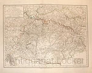
Carte de la Hongrie, de la Transilvanie et de Pays Adja cents Appartenants a la Maison d`Autriche. Zeitgenössisch grenzkolorierte Kupferstichkarte.
Verlag: Paris, um 1800., 1800
Plattengröße:44x34 cm, Blattgröße: 56,9x43,4 cm; verstärkter Mittelfalz, No. 102 im linken Plattenrand, in der Mitte im ob. Plattenrand: Longitude de Meridien de l`Isle de Fer;, im unt. Plattenrand Longitude Orientale du Meridien de Paris; sauberes, deko.
-
Verlag: Paris, Chanlaire u. Mentelle, um 1796., 1796
Anbieter: Antiquariat MEINDL & SULZMANN OG, Wien - Vienna, Österreich
Bewertung:
Ca. 48 x 57 cm. Vgl. Bonacker S. 65 u. 158.- Die Karte zeigt Ägypten mit dem Verlauf des Nil von Assuan bis zur Mündung, einen Teil vom Roten Meer und die Halbinsel Sinai. Mit einer Teilkarte vom Nildelta, "Carte particuličre et détaillée du Delta".- Sauberer Erhaltungszustand. Graphik - Landkarten.