
Gesamtpreis (1 Artikel Artikel):
Versandziel:

LINDEMAN, O (11 Ergebnisse)
Direkt zu den wichtigsten Suchergebnissen
Produktart
- Alle Produktarten
- Bücher (11)
- Magazine & Zeitschriften
- Comics
- Noten
- Kunst, Grafik & Poster
- Fotografien
- Karten
-
Manuskripte &
Papierantiquitäten
Zustand
- Alle
- Neu
- Antiquarisch/Gebraucht
Einband
Weitere Eigenschaften
Land des Verkäufers
Verkäuferbewertung
-

t Was anders
Verlag: Europese Bibliotheek/De Zeeuwsche Boekhandel, Zaltbommel, 1978
ISBN 10: 9028850554ISBN 13: 9789028850552
Buch
Gebonden. Zustand: Boek goed. 165 pp. Zwart-wit illustraties. Met naamregister. Het boek belicht enige figuren, feiten en toestanden uit de laatste decennia van de negentiende en de eerste van de twintigste eeuw.
-
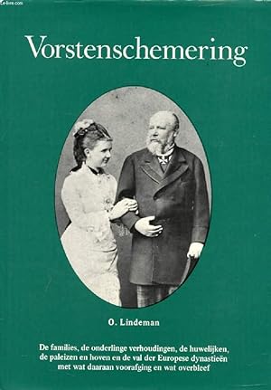
Couverture rigide. Zustand: bon. RO60089022: 1974. In-8. Relié. Bon état, Couv. convenable, Dos satisfaisant, Intérieur frais. 239 pages. Illustré de nombreuses photos en noir et blanc hors texte, et d'un arbre généalogique sur longue planche dépliable en fin d'ouvrage. Texte en néerlandais. Jaquette déchirée avec un manque important sur le bord supérieur. Avec Jaquette. . . Classification Dewey : 490-Autres langues.
-
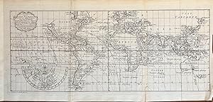
Fullt title: Nieuwe en Nette Zeekaart van de Geheele Waareld toonende de Afwijkingen van het kompas gelijk zij bevonden zijn anno 1700 met eene aanwijzing der Algmene en op de kusten waaiende passat winden en van de Moulons of veranderende passaat winden. Gemaakt onder 't opzigt van Kapitein Edmund Halley. Map made by O. Lindeman in Almelo fecit 1775. With 4 visible verticle folds and small creaes on the edges, a bigger crease on the bottom right.Halley did research on the conditions of terestrial magnetism. The results were published in General chart of the variation of the Compass. This was the first chart to be published and the first on which isogonic, or Halleyan, lines appeared. The use of such lines inspired later ideas such as those of isotherms by Alexander von Humboldt in his maps.World map after data of Edmond Halley ca. 1700, published by O. Lindeman in Almelo. With particular attention to the prevailing winds. With a demi-hemisphere insert map of the North Pole.[NL] Antieke zeekaart met de afwijkingen van het kompas door magnetisme. Gemaakt door de beroemde astronomist en natuurkundige Edmund Halley. Edmond of Edmund Halley (1656-1742) was een Engelse astronomist, wiskundige en natuurkundige. .
-

Couverture souple. Zustand: Bon. LINDEMAN (F. O.). Einführung in die Laryngaltheorie.Unter Mitwirkung von C. Hj. Borgstram (Sammlung Göschen, Band 1247/1247a).Berlin, 1970, in-16, br. 100 gr.
-
The Generals Go To War A Study Of Advertising And Sales Methods Of A Fast - Growing Industry
Verlag: Business Publications, Greensboro, N. C., 1930
Anbieter: Alexander Books (ABAC/ILAB), Ancaster, ON, Kanada
Bewertung:

Erstausgabe
Hardcover. Zustand: Near Fine. 1st Edition. 116 Pages. Book.
-
Die zweite Deutsche Nordpolarfahrt in den Jahren 1869 und 1870 unter Führung des Kapitän Koldewey.
Anbieter: Redins antikvariat, Enköping, Schweden
Bewertung:
Volksausgabe im Auftrage des Vereins für die Deutsche Nordpolarfahrt in Bremen bearbeitet. Mit 54 Illustrationen in Holzschnitt und 4 lithographierten Karten. Leipzig 1875. xiv,273 pages + maps and plates. Slightly worn half cloth.[#200005].
-
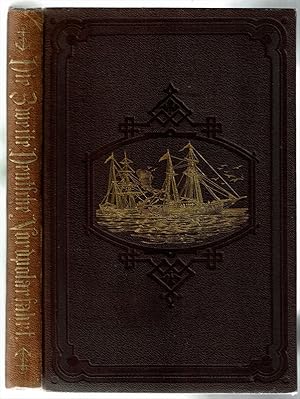
Die zweite Deutsche Nordpolarfahrt in den Jahren 1869 und 1870 unter Führung des Kapitän Koldewey. Volksausgabe.
Verlag: Leipzig, Brockhaus, 1883
Buch
Zustand: Gut. Neue Ausgabe. 273 S.mit 54 Illustrationen in Holzschnitt und 4 lithographierte Karten. (erste und letzte Seiten braunfleckig, Kapitale berieben) Ich versende mit der Deutschen Post (Büchersendung) und der DHL (Pakete). Die Lieferzeit ist abhängig von der Versandart und beträgt innerhalb Deutschlands 3-5 Tage, in der EU 5 - 14 Tage. Sprache: Deutsch Gewicht in Gramm: 300 Brauner geprägter OLeineneinband.
-
![Bild des Verkäufers für [Atlas van het Heilige Land] De XIIde Landkaart vertoonende De Landen der Assyrische, Babylonische, Persische, Grieksche en daarna Romeinsche Heerschappy, ter Ophelderinge der Profetien en Geschiedenissen der H. Schrift. [Heilige geographie of aardrijkskundige beschryving van het Joodsche land, etc., etc.] [ORIGINAL 18th CENTURY COPPERPLATE MAP OF THE HOLY LAND]. zum Verkauf von Librarium of The Hague](https://pictures.abebooks.com/inventory/md/md413720266.jpg)
[Atlas van het Heilige Land] De XIIde Landkaart vertoonende De Landen der Assyrische, Babylonische, Persische, Grieksche en daarna Romeinsche Heerschappy, ter Ophelderinge der Profetien en Geschiedenissen der H. Schrift. [Heilige geographie of aardrijkskundige beschryving van het Joodsche land, etc., etc.] [ORIGINAL 18th CENTURY COPPERPLATE MAP OF THE HOLY LAND].
Verlag: Utrecht, Paddenburg, 1768
Buch Erstausgabe
Print. Zustand: . ~ [TEMPORARY REDUCTION SALE: 20-30% OFF THE REGULAR PRICE] ~ (illustrator). 1st Edition. Original single-sheet map in copperplate engraving of fine quality. Overall size ca. 400 x 800 mm, with 2 flapped wings. Image size, within plate mark, ca. 340 x 740 mm. Handsome ornate cartouche encloses engraved title and colophon. Fine, strong impression on heavy handmade paper with ample margins all round. First, original state, unaltered by later colouration. Preserved flat in acid-free, pH-balanced, buffered archival paper. In fine condition. - - FIRST EDITION. Willem Albert Bachiene (1712-1783), Dutch clergyman, later a professor of geography and astronomy at the Illustere School, Maastricht. Well known cartographer. The 3-volume "Heilige geographie of aardrijkskundige beschryving van het Joodsche land, alsmede andere landen in de H. Schrift voorkomende," is considered among his most important works. It was published in Utrecht between 1763-1768, and included a suite of 12 fine geographical maps of the Holy Land and its neighbouring lands which Bachiene made during a period of ten years, the first in as early as 1758. The map offered herewith is taken from this suite. Other important cartographic works of the Holy Land by Bachiene were included in the so-called "Jehovah Bible" i.e. "De Gansche H. Schrift, Vervattende alle de regelmatige Boeken des Ouden en Nieuwen Testaments (.) Gods Gedenk-Naam Jehovah onvertaald gehouden" published in 1762 by N. Goetzee of Gorinchem, shortly before the present map first appeared in book form. Whereas other single-sheet maps by Bachiene are in relative abundance, mostly with added colouration for purely decorative purpose, the works from "Heilige geographie of aardrijkskundige beschryving van het Joodsche land" are very scarce, seldom found in any state. They are practically unavailable in their original, unaltered, uncoloured state. FOLIO.
-
![Bild des Verkäufers für [Atlas van het Heilige Land] De Iste Landkaart of Afbeelding van de Natuurlyke Gesteldheid des Lands Kanaan, waar in de Zeën, rivieren, beeken gelyk ook de bergen, dalen, en vlakten, de woestynen enz. dezes lands, die in de H. Schrift genoemt zyn, worden aangewezen. [Heilige geographie of aardrijkskundige beschryving van het Joodsche land, etc., etc.] [ORIGINAL 18th CENTURY COPPERPLATE MAP OF THE HOLY LAND]. zum Verkauf von Librarium of The Hague](https://pictures.abebooks.com/inventory/md/md440536020.jpg)
[Atlas van het Heilige Land] De Iste Landkaart of Afbeelding van de Natuurlyke Gesteldheid des Lands Kanaan, waar in de Zeën, rivieren, beeken gelyk ook de bergen, dalen, en vlakten, de woestynen enz. dezes lands, die in de H. Schrift genoemt zyn, worden aangewezen. [Heilige geographie of aardrijkskundige beschryving van het Joodsche land, etc., etc.] [ORIGINAL 18th CENTURY COPPERPLATE MAP OF THE HOLY LAND].
Verlag: Utrecht, Paddenburg, 1757
Buch Erstausgabe
Print. Zustand: . ~ [TEMPORARY REDUCTION SALE: 20-30% OFF THE REGULAR PRICE] ~ (illustrator). 1st Edition. Original single-sheet map in copperplate engraving of fine quality. Overall size ca. 400 x 510 mm. Plate mark ca. 365 x 445 mm. Image size ca. 340 x 420 mm. Engraved illustration at lower right corner. Handsome illustrated cartouche encloses engraved title and colophon. Scale within illustrated frame. Fine, strong impression on heavy handmade paper with ample margins all round. First, original state, unaltered by later colouration. Preserved flat in acid-free, pH-balanced, buffered archival paper. In fine condition. (A touch of browning to centrefold.) ~ FIRST EDITION. Willem Albert Bachiene (1712-1783), Dutch clergyman, later a professor of geography and astronomy at the Illustere School, Maastricht. Well known cartographer. The 3-volume "Heilige geographie of aardrijkskundige beschryving van het Joodsche land, alsmede andere landen in de H. Schrift voorkomende," is considered among his most important works. It was published in Utrecht between 1763-1768, and included a suite of 12 fine geographical maps of the Holy Land and its neighbouring lands which Bachiene made during a period of ten years, the first in as early as 1758. The map offered herewith is taken from this suite. Other important cartographic works of the Holy Land by Bachiene were included in the so-called "Jehovah Bible" i.e. "De Gansche H. Schrift, Vervattende alle de regelmatige Boeken des Ouden en Nieuwen Testaments (.) Gods Gedenk-Naam Jehovah onvertaald gehouden" published in 1762 by N. Goetzee of Gorinchem, shortly before the present map first appeared in book form. Whereas other single-sheet maps by Bachiene are in relative abundance, the works from "Heilige geographie of aardrijkskundige beschryving van het Joodsche land" are very scarce, seldom found in any state, practically unavailable in their original, uncoloured state. FOLIO.
-
[Atlas van het Heilige Land] De IIIde Landkaart 't Land Kanaan en Gilead onder de XII Stammen Israëls Verdeelt. [Heilige geographie of aardrijkskundige beschryving van het Joodsche land, etc., etc.] [ORIGINAL 18th CENTURY COPPERPLATE MAP OF THE HOLY LAND].
Verlag: Utrecht, Paddenburg, 1758
Buch Erstausgabe
Print. Zustand: . ~ [TEMPORARY REDUCTION SALE: 20-30% OFF THE REGULAR PRICE] ~ (illustrator). 1st Edition. Original single-sheet map in copperplate engraving of fine quality. Overall size ca. 400 x 510 mm. Plate mark ca. 360 x 445 mm. Image size ca. 345 x 425 mm. With Inset Map, "Der Verdeelinge van Israels Land", measuring ca. 150 x 110 mm, presented by two, finely engraved cherubs. Engraved illustration, depicting Joshua's men about to embark on the entry into the Promised Land. Illustrated cartouche encloses engraved title and colophon. Fine, strong impression on heavy handmade paper with ample margins all round. First, original state, unaltered by later colouration. Preserved flat in acid-free, pH-balanced, buffered archival paper. In a very fine condition. - - FIRST EDITION. Willem Albert Bachiene (1712-1783), Dutch clergyman, later a professor of geography and astronomy at the Illustere School, Maastricht. Well known cartographer. The 3-volume "Heilige geographie of aardrijkskundige beschryving van het Joodsche land, alsmede andere landen in de H. Schrift voorkomende," is considered among his most important works. It was published in Utrecht between 1763-1768, and included a suite of 12 fine geographical maps of the Holy Land and its neighbouring lands which Bachiene made during a period of ten years, the first in as early as 1758. The map offered herewith is taken from this suite. Other important cartographic works of the Holy Land by Bachiene were included in the so-called "Jehovah Bible" i.e. "De Gansche H. Schrift, Vervattende alle de regelmatige Boeken des Ouden en Nieuwen Testaments (.) Gods Gedenk-Naam Jehovah onvertaald gehouden" published in 1762 by N. Goetzee of Gorinchem, shortly before the present map first appeared in book form. Whereas other single-sheet maps by Bachiene are in relative abundance, the works from "Heilige geographie of aardrijkskundige beschryving van het Joodsche land" are very scarce, seldom found in any state, practically unavailable in their original, uncoloured state. FOLIO.
-
[Atlas van het Heilige Land] Heilige geographie of aardrijkskundige beschryving van het Joodsche land, etc., etc. [5 ORIGINAL 18th CENTURY COPPERPLATE MAPS OF THE HOLY LAND].
Verlag: Utrecht, Paddenburg, 1757-67., 1757
Buch Erstausgabe
Print. Zustand: . ~ [TEMPORARY REDUCTION SALE: 20-30% OFF THE REGULAR PRICE] ~ (illustrator). 1st Edition. Lot of 5 original single-sheet maps in copperplate engraving of fine quality. Fine, strong impressions on heavy handmade paper with ample margins all round. First, original state, unaltered by later colouration. Preserved flat in acid-free, pH-balanced, buffered archival paper. In fine condition. - - Full individual descriptions are available on request. - - FIRST EDITION. Willem Albert Bachiene (1712-1783), Dutch clergyman, later a professor of geography and astronomy at the Illustere School, Maastricht. Well known cartographer. The 3-volume "Heilige geographie of aardrijkskundige beschryving van het Joodsche land, alsmede andere landen in de H. Schrift voorkomende," is considered among his most important works. It was published in Utrecht between 1763-1768, and included a suite of 12 fine geographical maps of the Holy Land and its neighbouring lands which Bachiene made during a period of ten years, the first in as early as 1758. The map offered herewith is taken from this suite. Other important cartographic works of the Holy Land by Bachiene were included in the so-called "Jehovah Bible" i.e. "De Gansche H. Schrift, Vervattende alle de regelmatige Boeken des Ouden en Nieuwen Testaments (.) Gods Gedenk-Naam Jehovah onvertaald gehouden" published in 1762 by N. Goetzee of Gorinchem, shortly before the present map first appeared in book form. Whereas other single-sheet maps by Bachiene are in relative abundance, the works from "Heilige geographie of aardrijkskundige beschryving van het Joodsche land" are very scarce, seldom found in any state, practically unavailable in their original, uncoloured state. - - Note regarding this lot: Each of the 5 maps in this lot is offered also separately. [Descriptive text Copyright Librarium, The Hague] FOLIO.
