Gesamtpreis (1 Artikel Artikel):
Versandziel:

KAERIUS, PETRUS (64 Ergebnisse)
Direkt zu den wichtigsten Suchergebnissen
Produktart
- Alle Produktarten
- Bücher (52)
- Magazine & Zeitschriften
- Comics
- Noten
- Kunst, Grafik & Poster (5)
- Fotografien
- Karten (7)
-
Manuskripte &
Papierantiquitäten
Zustand
- Alle
- Neu
- Antiquarisch/Gebraucht
Einband
- alle Einbände
- Hardcover (5)
- Softcover
Weitere Eigenschaften
Land des Verkäufers
Verkäuferbewertung
-

Imago Mundi: A Review of Early Cartography Supplement No. V
Verlag: Amsterdam N. Israel
Anbieter: Wonder Book, Frederick, MD, USA
Bewertung:

Zustand: Good. Good condition. Supplement No. V. (Early Cartography, History, European maps) A copy that has been read but remains intact. May contain markings such as bookplates, stamps, limited notes and highlighting, or a few light stains.
-
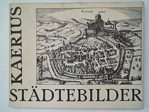
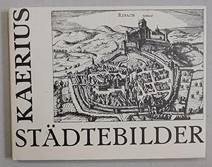
Praecipuarum urbium Germaniae Superioris Iconismi et effigies, Graphice delineatae. Städtebilder.
Verlag: Unterschneidheim, Vlg. Walter Uhl, 1972
Buch
gebundene Ausgabe, Zustand: Gut. Reprint. Mit 107 Ansichten Schutzumschlag gebräunt und mit Knickspuren am Rand, in gutem Zustand, KU-3003 Sprache: Deutsch Gewicht in Gramm: 550.
-
Praecipuarum urbium Germaniae Superioris Iconismi et effigies, Graphice delineatae. Städtebilder.
Anbieter: Antiquariat Martin Barbian & Grund GbR, Saarbruecken, Deutschland
Bewertung:
Buch
Unterschneidheim, Walter Uhl, 1972. Quer-Gr.-8°, etwa 100 S., durchgehend mit Abbildungen nach alten Kupferstichen, Original-Leinwandeinband mit Original-Schutzumschlag in schöner Erhaltung (AT).
-
Praecipuarum urbium Germaniae superioris iconismi & effigies, graphice delineatae (Kaerius Städtebilder). Nachdruck der Ausgabe Amsterdam, 1619.
Verlag: Unterschneidheim: Uhl 1972., 1972
Anbieter: Antiquariat Bergische Bücherstube Mewes, Overath, Deutschland
Verbandsmitglied: GIAQ ILAB VDA
Bewertung:
ca. 150 S. mit Abb. Quer 8° Ln.mS. *In der Tradition von Braun & Hogenberg *Umschlag berieben, innen sauberes, gutes Expl.*.
-
Praecipuarum urbium Germaniae superioris iconismi & effigies, graphice delineatae (Umschlag: Kaerius Städtebilder).
Verlag: Unterschneidheim, Verlag Walter Uhl, 1972 (Nachdruck der Ausgabe Amsterdam, 1619)., 1972
Anbieter: Versandantiquariat Wolfgang Friebes, Graz, Österreich
Bewertung:

Erstausgabe
Zustand: 0. Erste Ausgabe dieses Nachdruckes mit einem neuen zweiseitigen Vorwort. - Umschlag etw. fleckig u. tlw. leicht berieben. ge Gewicht in Gramm: 500 Qu.-Gr.-8°. 56 nn. Bll., OLwd. m. illustr. OUmschlag.
-
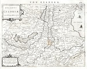
Dvcatvs Geldriae novissima descriptio
Verlag: Janssonius, Johannes, Amsterdam, 1648
"Ducatus Geldriae novissima descriptio". Orig. copperplate engraving. Published by J. Janssonius in Amsterdam, 1648-51. With ornamental title-cartouche, another cartouche with the scale of map ("Milliaria Germanica . Gallica communia") and German title above the map ("Von Geldern"). 15,5:20,5 cm (6 1/4 x 8 inch.). Koeman III, map 3700:352.1, ed. 352:32/33 (1648-51 German). - A miniature map of Gelderland. - Lower left margin cutted closely to the desk. A small water stain in the centre.
-
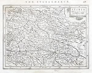
Stiria
Verlag: Janssonius, Johannes, Amsterdam, 1648
"Stiria". Orig. copperplate engraving, P. Kaerius (van der Keere). Published by J. Janssonius in Amsterdam, 1648-51. With ornamental title-cartouche with the scale of map ("Milliaria Germa. commu.") and German title above the map ("Von Steyermarck"). 14,5:19,5 cm (5 3/4 x 7 3/4 inch.). Koeman III, map 2730:352.1, ed. 352:32/33 (1648-51 German). - A miniature map of Styria.
-
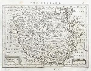
Brabantiae Ducatus
Verlag: Janssonius, Johannes, Amsterdam, 1648
"Brabantiae Ducatus". Orig. copperplate engraving, P. Kaerius (van der Keere). Published by J. Janssonius in Amsterdam, 1648-51. With ornamental title-cartouche, another cartouche with the scale of map ("Milliaria Germanica com.") and German title above the map ("Von Braband"). 15:20,5 cm (6 x 8 inch.). Koeman III, map 3100:352.1, ed. 352:32/33 (1648-51 German). - A miniature map of Brabant.
-
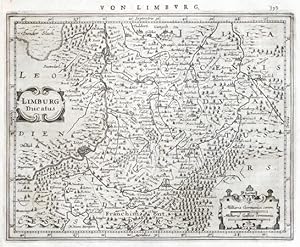
Limburg Ducatus
Verlag: Janssonius, Johannes, Amsterdam, 1648
"Limburg Ducatus". Orig. copperplate engraving, P. Kaerius (van der Keere). Published by J. Janssonius in Amsterdam, 1648-51. With ornamental title-cartouche, another cartouche with the scale of map ("Milliaria Germanica . Gallica communia") and German title above the map ("Von Limburg"). 16:20 cm (6 1/4 x 8 inch.). Koeman III, map 3170:352.1, ed. 352:32/33 (1648-51 German). - A miniature map of Limburg. - Left margin cutted closely to the desk.
-
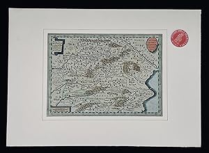
Kolorierter Orig.-Kupferstich von Petrus Kaerius, ( Amsterdam: Janssonius, 1628 ). Mit einer Längenmaß-Kartusche (links) und der Titel-Kartusche (rechts) sowie der Seitenzahl "599" über der Umrandung rechts sowie rückseitigem Text (auf S. 600): "cuis abundat: Pecoribus, Armentisque frequens. (.) endend: "In ea sunt hae civitates, Maresa, Rhinocorura," - Motiv: 13 x 19 auf Blatt: 15 x 21 cm. * Gut erhalten !.
-
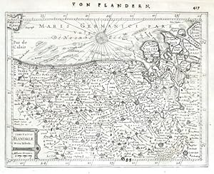
Comitatus Flandriae Nova Tabula
Verlag: Janssonius, Johannes, Amsterdam, 1648
"Comitatus Flandriae Nova Tabula". Orig. copperplate engraving, P. Kaerius (van der Keere). Published by J. Janssonius in Amsterdam, 1648-51. With ornamental title-cartouche with the scale of map ("Milliaria Germanica") and German title above the map ("Von Flandern"). 15,5:20,5 cm (6 1/4 x 8 inch.). Koeman III, map 3200:352.1, ed. 352:32/33 (1648-51 German). - A miniature map of Flanders.
-
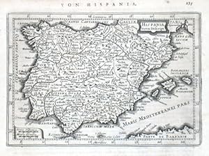
Hispania nova Descript.
Verlag: Janssonius, Johannes, Amsterdam, 1628
"Hispania nova Descript.". Orig. copperplate engraving by P. van den Keere (Kaerius). Published in Amsteradam by J. Janssonius, 1648. With ornamental title-cartouche, decorative cartouche with the scale of map ("Leucae Hispanicae. Miliaria Germania") and German heading title ("Von Hispania"). 13,5:19,5 cm (5 1/4 x 7 3/4 inch.). Koeman III, map 6000:352.1, ed. 352:32/33 (1648-51 German) - A miniature map of Spain.
-
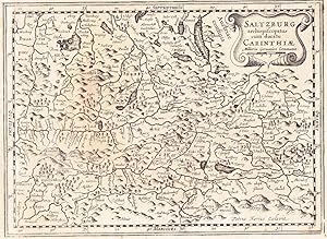
Kupferstichkarte 18,5 x 25,5 cm (Plattenrand) mit Titelkartusche. Kaerius (eig. Pieter van der Keere) nahm hier als Vorbild die Karte von Mercator aus dem Atlas Minor" (1610). Oberhalb mit der Bezeichnung Salisburgensis Episcopatus" und der Seitenzahl 541, rückseitig mit dem lateinischen Text (Anfang von Carinthiae Ducatus").
-

Germania. -
Verlag: [Um 1650]., 1650
Kunst / Grafik / Poster
Alt-teilkolorierter Kupferstich, 18,5 x 25,5 cm, Blattgröße 21,5 x 29 cm. Der Kupferstich von Petrus Kaerius oder Pieter van der Keere zeigt Deutschland mit den angrenzenden Ländern. In der linken unteren Ecke eine einfache Titelkartusche mit Meilenanzeiger. Über dem Bild der Titel in französischer Sprache: "De toute la Germanie en general". Rückseitig französischer Text. Nord- und Ostsee koloriert, ebenso die Grenzen, die größeren Städte, Gebirgszüge und Waldgebiete. Petrus Kaerius oder Pieter van der Keere 1570 1630, holländischer Kupferstecher und Verleger, T.-B. 20,57. Saubere Darstellung.
-
Altkolorierte Kupferstichkarte, 25 cm x 19 cm, zertifiziert vom Kunst-Antiquariat Hans Horst Koch, gerahmt mit Passpartout, sehr gutes Exemplar, gerahmte Original-Karte,
-
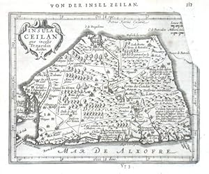
Insula Ceilan quae incolis Tenarisin dicitur
Verlag: Janssonius, Johannes, Amsterdam, 1651
Ceylon."Insula Ceilan quae incolis Tenarisin dicitur". Orig. copperplate engraving after P. van den Keere's map of Ceylon from G. Mercator's Atlas Minor. Published in Amsterdam by J. Janssonius, 1651. With ornamental title-cartouche, the scale of map and German title ("Von der Insel Zeilan") above the map. 14,5:18,5 cm (5 3/4 x 7 1/4 inch.). Koeman III, map 8380:352A ("In later editions the top right corner of the plate is broken off"), ed. 352:33 (1651 German) - A miniature map of Ceylon. Oriented to the East.
-
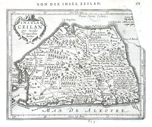
Insula Ceilan quae incolis Tenarisin dicitur
Verlag: Janssonius, Johannes, Amsterdam, 1651
Ceylon."Insula Ceilan quae incolis Tenarisin dicitur". Orig. copperplate engraving after P. van den Keere's map of Ceylon from G. Mercator's Atlas Minor. Published in Amsterdam by J. Janssonius, 1651. With ornamental title-cartouche, the scale of map and German title ("Von der Insel Zeilan") above the map. 14,5:18,5 cm (5 3/4 x 7 1/4 inch.). Koeman III, map 8380:352A ("In later editions the top right corner of the plate is broken off"), ed. 352:33 (1651 German) - A miniature map of Ceylon (Sri Lanka). Oriented to the East.
-
Zustand: Gut. Gut. Kupferstich unter Passepartout, altkoloriert. Blattgröße: 25 x 38 cm, Druckspiegel: 18 x 25 cm. . Kräftiger und klarer Druck auf leicht gebräuntem Papier, insgesamt gut erhalten. Schöne mittelgroße Landkarte von Kastilien, Castilla, Castiliae, (Castiliae Veteris et Novae Descriptio), aus: Gerard Mercator und Henricus Hondius "Atlas Minor", Amsterdam um 1630. Landkarte, map, carte géographique, carta geografica, Spanien, Nordspanien, Spain, Espagnia, Espana, Spagna, Castilia, Kastillien, Castile, Castiglia, Castille. 1200 Gramm.
-
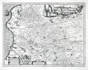
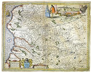
Artesia Descriptio
Verlag: van den Keere, Pieter, Amsterdam, 1617
Artois. "Artesia Descriptio". Orig. copperplate engraving after J. Surhons map of the region. Published by P. Kaerius (P. van den Keere), Amsterdam, in his atlas "Germania Inferior", 1617. With ornamental title-cartouche, a cartouche with the scale of map, great coat-of-arms, another cartouche with the view of the city of Arras ("Atrebatum", 4:13 cm), a wind-rose and a ship. 37:48 cm (14 1/2 x 19 inch.) Koeman III, map 3300:364, ed. 364:01 (1617 Latin) - A decorative map of Artois in northwestern France.
-
Artesia Descriptio. Johanne Surhonio Montensi auctore.
Verlag: Amsterdam -22., 1621
Anbieter: Robert Frew Ltd. ABA ILAB, London, Vereinigtes Königreich
Verbandsmitglied: ABA ILAB PBFA
Bewertung:
Karte
Original hand-coloured engraved map(37 x 47 cm, overall 38.5 x 49 cm.) inset view of Atrebatum [Arras]. Neat repairs to verso at top and bottom of centre fold, verso overall browned, slight browning and surface rubbing to recto.
-
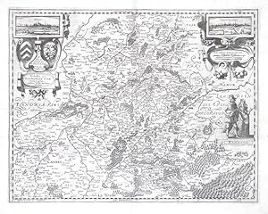
Nobilis. Hannoniae Com. Descriptio
Verlag: van den Keere, Pieter, Amsterdam, 1617
"Nobilis. Hannoniae Com. Descriptio". Orig. copperplate engraving after J. Surhon's map of the region. Published in Amsterdam by P. Kaerius (P. van den Keere),in his atlas "Germania Inferior", 1617. With ornamental title-cartouche with 2 coats-of-arms and a view of the city of Mons (3,5:8 cm), a cartouche with the scale of map and a view of French city of Valenciennes (3,5:8 cm) and 2 figures. 37:48 cm (14 1/2 x 19 inch.). Koeman III, map 3320:364, ed. 364:01 (1617 Latin) - A decorative map of Belgian region of Hainaut. Rare.
-
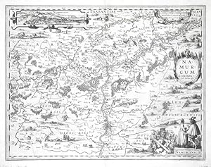
Namurcum Comitatus
Verlag: van den Keere, Pieter, Amsterdam, 1617
"Namurcum Comitatus". Orig. copperplate engraving after J. Surhon's map of the region. Published by P. Kaerius (P. van den Keere), Amsterdam, in his atlas "Germania Inferior", 1617. With ornamental title-cartouche, a cartouche with the scale of map, another cartouche with a view of the city of Namur ("Namurcum", 3,5:17 cm), 2 figures and great coat-of-arms. 38:49,5 cm (15 x 19 1/2 inch.). Koeman III, map 3340:364, ed. 364:01 (1617 Latin) - A decorative map of Namur region in southern Belgium. Rare.
-
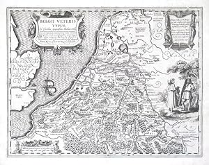
Belgii Veteris Typus
Verlag: van den Keere, Pieter, Amsterdam, 1617
"Belgii Veteris Typus". Orig. copperplate engraving after A. Ortelius' map of the region. Engraved and published by P. Kaerius (P. van den Keere), Amsterdam, in his atlas "Germania Inferior", 1617. With great ornamental title-cartouche, a cartouche with the scale of map, another cartouche with explanatory notes, 2 figures and a ship. 37,5:49 cm (14 3/4 x 19 1/4 inch.). Koeman III, map 3000H:364A, ed. 364:01 (1617 Latin) - A rare map of Benelux.
-
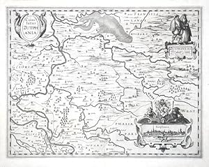
Comitatus Zutphania
Verlag: van den Keere, Pieter, Amsterdam, 1617
"Comitatus Zutphania". Orig. copperplate engraving, P. Kaerius (P. van den Keere), Amsterdam. Published in his atlas "Germania Inferior", 1617. With decorative title-cartouche, a cartouche with a view of the city of Zutphen ("Zutphania", 4,5:11 cm) and a coat-of-arms and another cartouche with the scale of map and 2 figures ("Zutphaneses"). 37,5:49 cm (14 3/4 x 19 1/4 inch.). Koeman III, map 3713:364, ed. 364:01 (1617 Latin) - A decorative map of the Zutphen region in the eastern Netherlands. Rare.
-
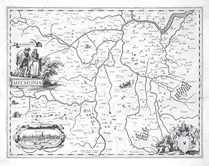
Mechlinia
Verlag: van den Keere, Pieter, Amsterdam, 1617
"Mechlinia". Orig. copperplate engraving, P. Kaerius (P. van den Keere), Amsterdam. Published in his atlas "Germania Inferior", 1617. With figure title-cartouche ("Mechlinienses"), a cartouche with a view of the city of Mechelen ("Mehlinia", 4:10 cm), a figure cartouche with great coat-of-arms and a carriage in the centre of the map. 37,5:48,5 cm (14 3/4 x 19 inch.). Koeman III, map 3160:364, ed. 364:01 (1617 Latin) - A decorative map of the city of Mechelen with its environs (cities Brüssel, Antwerpes, Aarschot etc.). - Rare.
-
Handkolorierter Orig.-Kupferstich mit gelb gerahmter Titelkartusche von P. Kaerius mit zwei Segelschiffen und einem Boot. Amsterdam: C. J. Visscher, 1649 (aus: Tabulae Geographicae Contrare). - Motiv: 8,5 x 12,5 auf Blatt "103": 10,5 x 15,5 cm. * Miniature map of the Island of Mozambique, off northern Mozambique, between the Mozambique Channel and Mossuril Bay, and is part of Nampula Province. Oriented to the West. With a netherlands text versus: "Beschryvinge van't Punt van Africa". - Koeman III, 8830:341, ed. 341:54 (1649 Tabulae, Visscher).
-
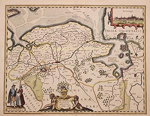
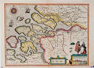
Groninga Dominium", copper engraving by Petrus Kaerius (Peter van der Keere) first published in 1617 in Amsterdam as part of Germaniae Inferior id est, XVII Provinciarum ejus novae et exactae Tabulae Geographicae, the first separately published atlas of the Seventeen Provinces Here in a second edition with French text on the verso side, published in 1622
Anbieter: Inter-Antiquariaat Mefferdt & De Jonge, Amsterdam, Niederlande
Bewertung:
Kunst / Grafik / Poster
"Groninga Dominium", copper engraving by Petrus Kaerius (Peter van der Keere) first published in 1617 in Amsterdam as part of Germaniae Inferior id est, XVII Provinciarum ejus novae et exactae Tabulae Geographicae, the first separately published atlas of the Seventeen Provinces Here in a second edition with French text on the verso side, published in 1622. Coloured by a later hand, Size: 37 x 48 cm. This fine early map of the Groningen region includes a view of the city of Groningen (copied from Lodovico Guicciardini) and two "Groningi" in their typical regional dress. Kaerius atlas "Germania Inferior" was published in only three editions: two in Latin in 1617 and one in French in 1622. After the death of his wife in 1623, Kaerius ran into financial difficulties and had to sell his copper plates. The new owner was Claes Jansz. Visscher, who reused them and brought the maps on the market under his own name. Price: Euro 1.350,-.
-
Kopergravure uitgegeven door Petrus Kaerius (Pieter van den Keere) in 1617
Anbieter: Inter-Antiquariaat Mefferdt & De Jonge, Amsterdam, Niederlande
Bewertung:
Kunst / Grafik / Poster
Kopergravure uitgegeven door Petrus Kaerius (Pieter van den Keere) in 1617. Verso Latijnse tekst. In de tijd met de hand gekleurd. Afm. 35 x 47cm. De koperen plaat waar deze kaart van gedrukt is, was eerder door een anonieme graveur vervaardigd, maar kwam in handen van Petrus Kaerius. Daar waar de kostuumfiguren staan stond eerst een cartouche met tekst, maar om de kaart in overeenstemming te krijgen met de andere kaarten van zijn atlas, paste Kaerius de plaat aan. Nu zien we rechtsonder een gezicht op Middelburg met twee Zeeuwen "Seelandi", gekleed in de mode van die tijd. Links van deze cartouche een schaalstok omgeven door een rolwerkcartouche, waarboven het uitgeversimpressum "Petrus keerius execud." Linksboven een prachtig gegraveerde 32-delige kompasroos omgeven door schepen en zeemonster. De kaart werd opgenomen in Kaerius' atlas "Germania Inferior". In totaal beleefde deze atlas slechts drie edities: twee edities in het Latijn in 1617 en een in het Frans in 1622. Na de dood van zijn vrouw in 1623, kwam Kaerius in financiële moeilijkheden en was hij verplicht zijn koperplaten te verkopen. De nieuwe eigenaar was Claes Jansz. Visscher, die de kaart voorzien zijn eigen naam opnieuw in de handel bracht. Met telkens kleine veranderingen werd deze kaart van Zeeland tot 1634 nog vijf maal uitgegeven. Prijs: Euro1.650,-.
-
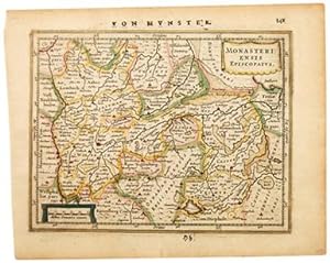
MONASTERIENSIS EPISCOPATUS.
Verlag: Atlas Minor. Jan Jansson. 1651, 2nd German edition., 1651
Anbieter: Peter Harrington. ABA/ ILAB., London, Vereinigtes Königreich
Verbandsmitglied: ABA ILAB PBFA
Bewertung:
A delightful map of Holland. From Jansson's edition of Mercator's Atlas Minor. Moreland & Bannister, Antique Maps, p.98. Copper engraving. Original colour. Fine condition. Size: 19 x 15 cm. (7˝ x 6 inches).
-
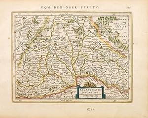
PALATINATUS BAVARIAE.
Verlag: Atlas Minor. Jan Jansson. 1651, 2nd German edition., 1651
Anbieter: Peter Harrington. ABA/ ILAB., London, Vereinigtes Königreich
Verbandsmitglied: ABA ILAB PBFA
Bewertung:
A delightful map of Bavaria, Germany. From Jansson's edition of Mercator's Atlas Minor. Moreland & Bannister, Antique Maps, p.98. Copper engraving. Original colour. Fine condition. Size: 18 x 14 cm. (7 x 5˝ inches).