
Gesamtpreis (1 Artikel Artikel):
Versandziel:

JANSSON, JOANNES (10 Ergebnisse)
Direkt zu den wichtigsten Suchergebnissen
Produktart
- Alle Produktarten
- Bücher (10)
- Magazine & Zeitschriften
- Comics
- Noten
- Kunst, Grafik & Poster
- Fotografien
- Karten
-
Manuskripte &
Papierantiquitäten
Zustand
- Alle
- Neu
- Antiquarisch/Gebraucht
Einband
- alle Einbände
- Hardcover (5)
- Softcover
Weitere Eigenschaften
- Erstausgabe
- Signiert
- Schutzumschlag
- Angebotsfoto (6)
Gratisversand
Land des Verkäufers
Verkäuferbewertung
-
Zustand: Gut. 198 ungezählte Blätter, Vollständiges Faksimile der 92 Karten nach dem Exemplar 2° Mapp 80-2 der Bayerischen Staatsbibliothek München. - Nachdruck der Ausgabe Amsterdam 1657/70. - Vorwort von Traudl Seifert. - Exemplar der Ausgabe A im Endi Silk-Einband (von Hand gesponnene und gewebte Seide aus Assam). - Sauberes und wohlerhaltenes Exemplar. ISBN: 9783870451233 Wir senden umgehend mit beiliegender MwSt.Rechnung. Sprache: Deutsch Gewicht in Gramm: 2500 OSeidenbd., goldgeprägter Deckel- und Rückenschild, 50 x 33 cm.
-
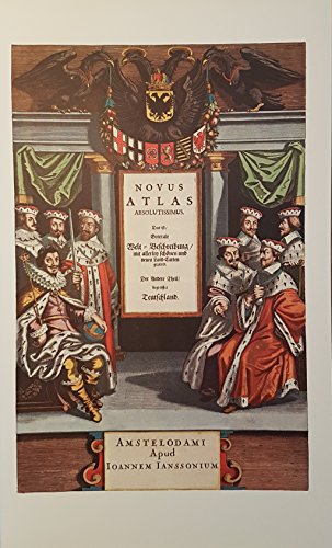
Novus atlas absolutissimus: das ist generale Welt-Beschreibung mit allerley schönen u. neuen Land-Carten gezieret. Der andere Theil begreiffet Teutschland. Faksimile [d. Ausg.] Amsterdam, Jansson, 1657/70. Vollständiges Faksimile der 92 Karten. Mit einer Einführung von Traudl Seifert.
Verlag: Battenberg, München, 1977
ISBN 10: 3870451238ISBN 13: 9783870451233
Buch
Hardcover. Folio. Wildseide (Endi Silk aus Assam) mit Lederrücken- und Deckelschild. gutes Exemplar.
-

Novus Atlas Absolutissimus. Das ist generale Welt-Beschreibung mit allerley schönen und neuen Land-Carten gezieret. Der andere Theil begreiffet Teutschland. Vollständiges Faksimile der 92 Karten nach dem Exemplar der Bayerischen Staatsbibliothek München.
Verlag: München, Battenberg, 1977., 1977
ISBN 10: 3870451246ISBN 13: 9783870451240
Buch
Hardcover. Mit einer Einführung von Traudl Seifert. Ausgabe B - goldgeprägter Lederband auf fünf Zierbünden, XI, ca. unnummerierte 400 Seiten im Schuber. Der grüne Ledereinband am Rücken aufgehellt. 50,6 x 31,8 cm. Vollständiges Faksimile der 92 Karten nach dem Exemplar 2° Mapp 80-2 der Bayerischen Staatsbibliothek München. Gewicht: 300.
-
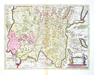
Bressia Vulgo Bresse
Verlag: Schenk, Peter & Valk, Gerard, Amsterdam, 1700
"Bressia Vulgo Bresse". copperplate engraving after J. Janssonius' map of the region. Published by P. Schenk & G. Valk, ca. 1700. Original old colouring. With decorative figure title-cartouche. 39,5:52 cm (15 1/2 x 20 1/2 inch.). A very decorative map of the Bresse, a region in south-eastern France, centered on the city of Bourg-en-Bresse and with the city of Lyon in the lower left corner.
-
![Bild des Verkäufers für Novus Atlas Absolutissimus. Das ist generale Welt-Beschreibung mit allerley schönen und neuen Land-Carten gezieret. Der andere Theil begreiffet Teutschland. Amsterdam [1657/70] bei Joannes Jansson. Mit einer Einführung von Traudl Seifert. zum Verkauf von Stefan Küpper](https://pictures.abebooks.com/inventory/md/md14485020129.jpg)
Vollständiges Faksimile der 92 Karten nach dem Exemplar 2° Mapp 80-2 der Bayerischen Staatsbibliothek München. Mit einer Einführung von Traudl Seifert. München, Battenberg 1977. Ausgabe B. Original-Ganzlederband im OSchuber. 50,6 x 31,8 cm. Rücken gehellt. Hinteres Innengelenk angeplatzt, jedoch fest in der Bindung.
-

Novus Atlas Absolutissimus Das ist generale Welt-Beschreibung mit allerley schönen und neuen Land-Carten gezieret,
Verlag: Battenberg, München, 1977
Vollständiges Faksimile der 92 Karten nach dem Exemplar 2° Mapp 80-2 der Bayerischen Staatsbibliothek München, Einführung von Traudl Seifert, Folio, Rückenleder durch Lichteinwirkung verfärbt, sonst sehr gutes Exemplar, goldgeprägtes grünes Original-Leder, im Original-Pappschuber,
-

Uplandia.
Verlag: Amsterdam: c.1650, 1650
Anbieter: Peter Harrington. ABA/ ILAB., London, Vereinigtes Königreich
Verbandsmitglied: ABA ILAB PBFA
Bewertung:

A striking and attractive map of Stockholm and environs by prominent Dutch cartographer and published Jan Jansson. This lovely map highlights the rugged coastline and the mountains within the vicinity of the Swedish capital. The map is adorned with a splendidly decorative title cartouche, galleons and a mileage scale beneath the regional Upland coat of arms. Copperplate engraving with early hand colour. German text on verso. Size: 485 x 575 mm Split to lower central fold and some age toning, otherwise in good condition.
-
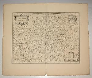
Original Engraved Antique Map of Nassovia Comitatus (County of Nassau.) Map shows Nordrhein-Westfalen with Siegen Rheinlandpfalz with Koblenz and Hessen with Wiesbaden.
Verlag: Amsterdam No date 1650, 1650
Anbieter: PROCTOR / THE ANTIQUE MAP & BOOKSHOP, DORCHESTER, Vereinigtes Königreich
Verbandsmitglied: PBFA
Bewertung:
Unmounted. Size 21 x 25 inches. Decorative Antique map With two orig. ornamental cartouches and large orig. Coat of arms. Shows Westerwald and Taunus with the Lahn river area (from Lollar to Lahnstein) in the center. In very good condition. A few faint marks on margins, and a couple of slight nicks. Inch split lower centre fold margin. Uncoloured,
-

Scotiae Pars Meridionalis.
Verlag: Amsterdam, 1633
Anbieter: Alexandre Antique Prints, Maps & Books, Toronto, ON, Kanada
Bewertung:

Latin text on verso., Size : 352x457 (mm), 13.875x18 (Inches), Hand Colored Very good, some marginal tears professionally restored hardly noticeable.
-
[MAP] PROVINCIA OXONIENSIS | OXFORD-SHIRE
Verlag: Joannes Janssonius, Amsterdam, 1644
Anbieter: BLACK SWAN BOOKS, INC., ABAA, ILAB, Richmond, VA, USA
Verbandsmitglied: ABAA ESA ILAB
Bewertung:
Zustand: Very Good binding. A map of Oxfordshire, with text from the atlas in Dutch and Fraktur on the verso. The map is hand-colored, with a bar scale in "Milliaria Anglica" and "Milliaria Germanica communia" in the upper left corner, decorated with garlands and cherubs; the title cartouche is in the upper right, decorated with ribbons and the face of a man placed obscurely at the bottom. Originally a two-page print from Janssonius' Nievwen Atlas. Vol. III., the plates were latter purchased first by Peter Schenk and Gerard Valk, then by John and Henry Overton. Jansson's original plates were later embellished by Schenk with longitudinal and latitudinal lines, as well as small town plans; Overton added roads to his printings. This early Jansson edition contains none of the later embellishments. Housed in a black wooden frame in Very Good condition. The map is 38 x 49 cm. Very Good binding.

![Bild des Verkäufers für [MAP] PROVINCIA OXONIENSIS | OXFORD-SHIRE zum Verkauf von BLACK SWAN BOOKS, INC., ABAA, ILAB](https://pictures.abebooks.com/inventory/md/md22859248612.jpg)