
Gesamtpreis (1 Artikel Artikel):
Versandziel:

DUPAIN TRIEL (5 Ergebnisse)
Direkt zu den wichtigsten Suchergebnissen
Produktart
- Alle Produktarten
- Bücher (4)
- Magazine & Zeitschriften
- Comics
- Noten
- Kunst, Grafik & Poster
- Fotografien
- Karten (1)
-
Manuskripte &
Papierantiquitäten
Zustand
Einband
- alle Einbände
- Hardcover
- Softcover (4)
Weitere Eigenschaften
- Erstausgabe
- Signiert
- Schutzumschlag
- Angebotsfoto (4)
Land des Verkäufers
Verkäuferbewertung
-

ÎLE-DE-FRANCE DUPAIN-TRIEL.La France connue sous ses plus utiles rapports, ou nouveau dictionnaire universel de France.Feuille des environs de Paris N° 1.P., chez l'auteur, 1786, in-8°, br., couv. muette d'époque, lég. défr., 115p. 100 gr.
-
Recherches Geographiques Sur Les Hauteurs Des Plaines Du Royaume, Sur Les Mers Et Leurs
Verlag: HACHETTE LIVRE, 2016
ISBN 10: 2019567628ISBN 13: 9782019567620
Buch
Kartoniert / Broschiert. Zustand: New.
-

Considerations Sur Les Arts Et Les Artistes Du Temps
Verlag: HACHETTE LIVRE, 2017
ISBN 10: 2013033524ISBN 13: 9782013033527
Buch
Zustand: New.
-

La France Connue Sous Ses Plus Utiles Rapports, Ou Nouveau Dictionnaire Universel de la France
Verlag: HACHETTE LIVRE, 2016
ISBN 10: 2013537328ISBN 13: 9782013537322
Buch
Zustand: New.
-
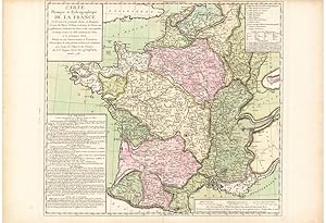
Carte Physique et Hydrographique de la France
Verlag: Paris: Jean-Louis DUPAIN-TRIEL, fils ., 1782
Anbieter: Antiquariat Dasa Pahor GbR, München, Deutschland
Bewertung:

Karte
Originally coloured copper engraving, 52,5 x 76 cm (20.5 x 30 inches) (soft vertical fold, minor age-toning in white margins, overall in a good condition). DATA VISUALISATION: A rare separately published map, made by a Royal geographic engineer Jean-Louis Dupain-Triel was published on the eve on the French Revolution and represents the hydrological structure and mountain ranges of France. Although the image appears to copy Philippe Buache's older map Carte physique ou géographie naturelle de la France, first published in 1744, this map is corrected and most notably includes pioneering new methods of representing the geographic data with contours. Marcellin Du Carla-Bonifas's "language of elevation" and Jean-Louis Dupain-Triel - In 1782 bought an unpublished work on map-making titled Expression des nivellements (Expression of Leveling) by a Languedocian geographer Marcellin Du Carla-Bonifas and published it in 600 examples, giving 150 examples to the author and keeping the rest for himself to resell. Marcellin Du Carla-Bonifas, who was ahead of his time, did not follow the established methods to represent the hydrography and elevation. He started measu of land at the sea level, what was at the time unusual for the military engineers. As Du Carla-Bonifas understood, that the sea level is arbitrary, he wanted to establish the average, by measuring the sea levels at the mouths of the rivers. Another one of his inventions in cartography was thickening every tenth contour line on the map, to make it clearer to read, calling the contours "the language of elevation". Du Carla-Bonifas generally believed one could add information on the map, without overcrowding it with printed data. He especially believed in clear contours, which would enable the reader to recognize the data instantly.After publishing Marcellin Du Carla-Bonifas's work on leveling, Jean-Louis Dupain-Triel copied Du Carla-Bonifas's ideas and published this map on hydrology of France. In the following years he continued publishing maps with more and more detailed and strong contour lines, with a hope, that the new government after the French Revolution would adopt his ideas. (Josef, CartogrFrance, 1660-1848: Science, Engineering, and Statecraft, 1987, pp. 77,78). Today the Dupain-Triel's maps are considered as curiosities in the elevation data visualisation. Worldcat does not list any examples. We could find examples in the Basel - Bern library database and at the list of maps at the Harvard library. References: Josef Konvitz, Cartography in France, 1660-1848: Science, Engineering, and Statecraft, 1987, pp. 77.
