Gesamtpreis (1 Artikel Artikel):
Versandziel:

CLUVER, PHILIPP (102 Ergebnisse)
Direkt zu den wichtigsten Suchergebnissen
Produktart
- Alle Produktarten
- Bücher (34)
- Magazine & Zeitschriften
- Comics
- Noten
- Kunst, Grafik & Poster (4)
- Fotografien
- Karten (64)
-
Manuskripte &
Papierantiquitäten
Zustand
- Alle
- Neu
- Antiquarisch/Gebraucht
Einband
- alle Einbände
- Hardcover (29)
- Softcover
Weitere Eigenschaften
- Erstausgabe (4)
- Signiert
- Schutzumschlag
- Angebotsfoto (76)
Land des Verkäufers
Verkäuferbewertung
-
Macedoniae et Thessaliae Regiones.
Verlag: [c.1620], 1620
Anbieter: Peter Harrington. ABA/ ILAB., London, Vereinigtes Königreich
Verbandsmitglied: ABA ILAB PBFA
Bewertung:

Detailed map of the region of Macedonia and Thessaly in Greece. Size: 242 x 328 mm Copper engraving. Original colour. Good condition.
-

Introductionis in universam geographiam, tum veterem quam novam libri VI. Amsterdam, Elzevir 1677. kl.8°. 2 folded plates. 352, 70 p., 5 leaves. Modern Cloth. Ownership inscription on flyleaf, throughout slightly browned, otherwise in very good condition.
-
Populorum GERMANIAE. Inter Rhenum et Albim Descriptio ut inter Coesaris et Trajam imperia Incoluerunt. Populorum GERMANIAE Inter Rhenum et Albim Descriptio ut circa I. Coesaris oevum Incoluerunt.
Verlag: Atlas Geographus. 1711-17, 1711
Anbieter: Peter Harrington. ABA/ ILAB., London, Vereinigtes Königreich
Verbandsmitglied: ABA ILAB PBFA
Bewertung:
An interesting piece which has two almost identical maps next to one another. Possibly using the original 17th century plates. A library stamp on reverse overlaps on left margin and slightly into image. Copper engraving. Later colour. Very good condition. Size: 260 x 205 mm.
-
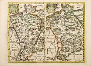
Vindeliciae et Norici, conterminarumque terrarum antiqua. (Vindelicians and Bavarians, with neighbouring ancient land)
Verlag: [c.1620], 1620
Anbieter: Peter Harrington. ABA/ ILAB., London, Vereinigtes Königreich
Verbandsmitglied: ABA ILAB PBFA
Bewertung:
Detailed map of ancient Germany and the lands of the Vindelicians and Bavarians, with a decorative cartouche showing an eagle astride an orb. Size: 231 x 305 mm Copper engraving. Original colour. Good condition.
-
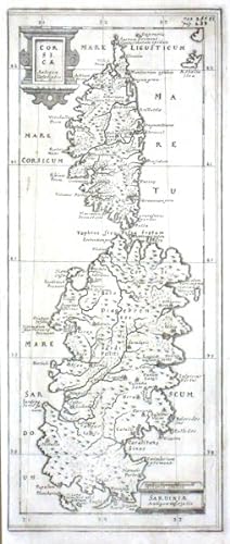
Corsicae Antiquae Descriptio. Sardiniae Antiquae Descriptio
Verlag: Wolfenbüttel, 1694
Karte
Kein Einband. Zustand: Gut bis sehr gut. "Corsicae Antiquae Descriptio. Sardiniae Antiquae Descriptio". Orig. copper-engraving, P. Cluver. Published in Wolfenbüttel, 1694. With 2 ornamental title-cartouches and the scale of map ("Miliaria Italica"). 27:11 cm (10 3/4 x 4 1/4 inch.). A miniature map of Corsica and Sardinia. - Philipp Cluver (also Clüver, Klüwer, Cluwer, or Cluvier, Latinized as Philippus Cluverius) (1580, Danzig - 1622, Leiden) was an Early Modern German geographer and historian.
-
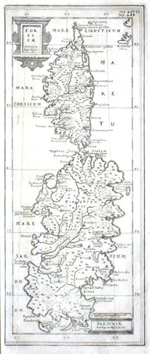
Corsicae Antiquae Descriptio. Sardiniae Antiquae Descriptio
Verlag: Cluver, Philipp, Wolfenbüttel, 1694
Corsica and Sardinia."Corsicae Antiquae Descriptio. Sardiniae Antiquae Descriptio". Orig. copperplate engraving, P. Cluver. Published in Wolfenbüttel, 1694. With 2 ornamental title-cartouches and the scale of map ("Miliaria Italica"). 27:11 cm (10 3/4 x 4 1/4 inch.). A miniature map of Corsica and Sardinia. - Philipp Cluver (also Clüver, Klüwer, Cluwer, or Cluvier, Latinized as Philippus Cluverius) (1580, Danzig - 1622, Leiden) was an Early Modern German geographer and historian.
-

Corsicae Antiquae Descriptio. Sardiniae Antiquae Descriptio
Verlag: Cluver, Philipp, Wolfenbüttel, 1694
"Corsicae Antiquae Descriptio. Sardiniae Antiquae Descriptio". Orig. copperplate engraving, P. Cluver. Published in Wolfenbüttel, 1694. With 2 ornamental title-cartouches and the scale of map ("Miliaria Italica"). 27:11 cm (10 3/4 x 4 1/4 inch.). A miniature map of Corsica and Sardinia. - Philipp Cluver (also Clüver, Klüwer, Cluwer, or Cluvier, Latinized as Philippus Cluverius) (1580, Danzig - 1622, Leiden) was an Early Modern German geographer and historian.
-
Sophorum Regnum.
Verlag: Leiden, 1675
Anbieter: Alexandre Antique Prints, Maps & Books, Toronto, ON, Kanada
Bewertung:

Karte
Size : 150x195 (mm), 5.875x7.625 (Inches), Hand Colored Very Good; some light darkening of the fold.
-
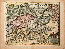
Helvetia Contermin arumq terra rum antiqua Descriptio Auctore
Verlag: Leiden, 1680
Anbieter: Alexandre Antique Prints, Maps & Books, Toronto, ON, Kanada
Bewertung:
Karte
Zustand: Excellent. Size : 206x255 (mm), 8.125x10 (Inches), Hand Colored.
-
Introductionis in universam geographiam tam veterem quam novam libri VI. Acceßit P. Bertij breviarium orbis terrarum,
Verlag: Amsterdam, Ludovicum Elzevirium 1651,., 1651
Buch
8x14, weißes Pgmt der Zeit, mit einem sehr hübschen gestochenen Titel (Landvermesser vor orientalischer Szenerie), schönen Kof- und Schluss-Vignetten sowie gestochenen Initialen, mit Sternzeichen und kalendarischen Tabellen im Text sowie mehrere mehrfach gefalteten Tafeln mit Windrosen, Zusammenstellungen von Längeneinheiten u.a., schöne frühe Ausgabe in einem ordentlichen Exemplar, lediglich innen stellenweise sehr leicht feuchtigkeitsspurig, mit einem Besitzvermerk von alter Hand, das vordere "fliegende Blatt" mit einer sauberen Rasur (ca ein Drittel des Blattes) la.
-
Nova Totius GERMANIAE DESCRIPTIO.
Verlag: c1620, 1620
Anbieter: Peter Harrington. ABA/ ILAB., London, Vereinigtes Königreich
Verbandsmitglied: ABA ILAB PBFA
Bewertung:
Detailed map of Germany and the adjacent territories, with a decorative cartouche showing a cherub and eagle astride an orb. Copper engraving. Later colour. Fine condition. Size: 32 x 25.5 cm. (12˝ x 10 inches).
-
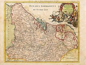
HODIERNAE BELGICAE five GERMANIA INFERIORIS Tabula
Verlag: Atlas Geographus. 1711-17, 1711
Anbieter: Peter Harrington. ABA/ ILAB., London, Vereinigtes Königreich
Verbandsmitglied: ABA ILAB PBFA
Bewertung:
A detailed and colourful map of what is now Belgium and part of north west Germany with Cluver's idiosyncratic elaborate cartouches. A library stamp on the reverse has been removed but shows slightly through and does not affect image. Copper engraving. Later colour. Very good condition Size: 26 x 21 cm. (10 x 8˝ inches).
-
Introductionis in universam geographiam, tam veterem quŕm novam, libri VI. Editio ultima piorib. emendatior. Amsterdam, Hondius 1637. 8°. 352 S., mit Kupfertitel, 2 gef. Kupfertafeln u. 1 gef. Tabelle, Prgt. d. Zt. mit Rücken- u. Deckelblindprägung.
Anbieter: Antiquariat Johannes Müller, Salzburg, Österreich
Bewertung:
Vgl. Graesse II, 204, Brunet 19607 u. Sabin 13805 (andere Ausg.).- Frühe Ausgabe (erstmals 1624 in Leiden erschienen).- Einleitung in die alte und neue Geographie, aus dem Nachlaß Philipp Cluvers (1580-1623) herausgegeben von Josephus Vorstius.- Die Kupfertafeln zeigen Windrosen u. Meridian Diagramme.- Nur gering gebräunt, zu Beginn im oberen Rand mit Wurmgang, sonst gutes Exemplar.# Early edition.- With engraved title-page, 2 folding engraved plates and 1 folding letterpress table.- This treatise, published posthumously, was the first "modern geography", and became a standard geographical textbook.- Bound in contemporary full vellum.
-
Introductionis in Universam geographiam tam veterem quam novam. Libri VI. Editio Postrema Recensita, emendate & ŕ multis quae in aiis editionibus circa historiam irrepserant mendis expurgara. Opera Petri Louvet [Petro Bertio's Breviarium Totius Orbis Terrarum
Verlag: Apud Antonii Laurens, Lugduni, 1666
Anbieter: James Cummins Bookseller, ABAA, New York, NY, USA
Bewertung:
Originally published in 1624. Originally published in 1624. Folding table, 2 folding plates only, maps lacking. Collates A-NN in 8s. 1 vols. 32mo. North America is described on pages 407 to 417. Sabin 13805 (not noting this edition) Contemporary vellum, manuscript title on spine. Some light soiling of vellum, endpapers removed, AA gathering misfolded, some browning and spotting, generally light, else a very good copy Folding table, 2 folding plates only, maps lacking. Collates A-NN in 8s. 1 vols. 32mo.
-
Corsicae / Sardiniae / Antiquae Descriptio
Verlag: c. 1694, 1694
Anbieter: Alexandre Antique Prints, Maps & Books, Toronto, ON, Kanada
Bewertung:
Karte
From "Introductio in omnem geographiam?"This is a small and interesting map of Corsica and Sardinia, indicating locations according to their ancient names. Two cartouches identify the islands., Size : 274x113 (mm), 10.79x4.45 (Inches), Hand Colored Very Good; right margin extended.
-
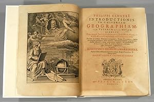
Introductio in Universam Geographiam
Verlag: Joannem Wolters, Amsterdam, 1697
Leather. Zustand: Good. Not Stated (illustrator). An important early modern geographical textbook by Philipp Cluver, a monumental work, this copy illustrated with a frontispiece. In the original Latin.ESTC citation number R223927.An important early modern study on Geography.This work, first published in 1624, was the first comprehensive modern geography, and subsequently became a standard geographical textbook.Illustrated with a frontispiece only, bound without the other plates and folding maps.By Philipp Cluver, an antiquarian, historian, and geographer, who is well known for his contributions to early modern study. In a full panelled calf binding. Externally, generally smart, with some light rubbing and marks to the boards and spine. Minor bumping to the spine and extremities, with a little loss to the head of the spine. Lacking most of the spine label. Small repair to the head and tail of the boards to the joints. Small cracks to the joints. Institutional label to the front paste down. Internally, firmly bound. Pages are lightly age-toned with the odd spot. Bound without the plates and maps. Prior owner's ink inscription to the head of the title page. Good. book.
-
Introductionis in universam geographiam, tam veterem quam novam libri VI. Tabulis aeneis illustrati. Acessit P. Bertii Brevarium orbis terrarum. Editio nova correctior et emendatior.
Verlag: Trajecti ad Rhenum, G. Broedelet 1717 1717, 1717
Anbieter: Rönnells Antikvariat AB, Stockholm, Schweden
Bewertung:
12:o. Engraved title, (10), 355, (83) pp. + 38 engraved double-page and folding maps + 1 folding table. Contemporary vellum. Book-plate. A few maps with small tears but overall a very good copy.
-
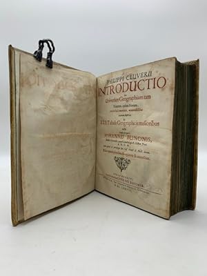
Philippi Cluverii Introductio in universam geographiam tam veterem, quam novam, multis locis emendata.Editio quarta prioribus locupletior & correctior
Verlag: Impensis heredum Conradi Bunonis, Brunsuigae, typis Johannis Henrici Dunckeri, Guelpherbyti, 1678
Anbieter: Coenobium Libreria antiquaria, Asti, Italien
Bewertung:

In 8 (cm 17,5 x 22,5), pp. (24) + 504 + (100) con 1 tavola incisa all'antiporta, 3 tavole fuori testo con la rosa dei venti, tabella con Typus intervallorum variarum gentium e tavola con schema illustrato a dimostrazione che la terra e' un globo, 1 tavola ripiegata con Typus orbis terrarum, 41 tavole ripiegate con cartine per un totale di 46 tavole fuori testo (esemplare completo di tutteÂle 42 carte geografiche). Mancano le sole 2 tavoleÂcon tabelle di testo a pagina 39 e a pagina 44 la cui assenzaÂnon e' generalmente menzionataÂnelle analoghe copie censite. Alcune carte brunite, gora leggera al frontespizio e ai 4 fogli successivi, piccolo tarlo al margine superiore bianco tra le pp. 127-147, piccolo restauro al margine esterno bianco di pagina 91. Frontespizio stampato in nero e rosso. Legatura coeva in piena pergamena. Quarta edizione di questa importante opera di Cluver, considerato il padre della moderna geografia,Âpubblicata numerose volte, almeno 17, tra 1624 e 1729.ÂPhilippÂCluver (1580-1622), umanista, cartografo e geografo tedesco, compi' numerosi viaggi per perfezionare la propria preparazione di geografo e risiedette a lungo anche in Italia. Questa opera e' considerata il primo tentativo di studio scientifico della geografia storica, disciplina che - secondo l'Autore - si deve avvalere del supporto di discipline collegate ovvero letteratura ed epigrafia. NellaÂcartina dell'America la California e' vista come un'isola, nella carta iniziale con il globo l'Australia e' indicata come semplice "Terra incognita", e' uno spazio solo abbozzato, a sud, dalle potenzialita' ancora insondate.ÂL'edizione del 1678, la quarta, nonche' la piu' completa e corretta, fu curata dallo storico, geografo e teologo tedesco Johan Buno o Bunone (1617-1697) che provvide a integrare e correggere il testo originale di Cluver".ÂAngelo Marrucci, "Imago mundi. Opere geografiche e cartografiche della Biblioteca Guarnacci di Volterra", 2004, p. 54. ITA.
-

2 Bände in 1. gest. Titel, 7 Bl., 786 S., 3 Bl., 787-1338 S., 11 Bl., 15 gefalt. Kupferstich-Karten, 1 Münzdarstellung im Text Berühmtes Werk über die Geographie des antiken Italien. Die Karten in hervorragender Druckqualität zeigen die Regionen Italiens, darunter eine Vogelschau-Ansicht von Rom. Das barocke Titelblatt mit allegorischer Darstellung der Flüsse Tiber und Po. Das gest. Portrait Cluvers. - Einband berieben und fleckig, Spiegel mit Randläsuren, vorderes Innengelenk geplatzt, erste und letzte 4 Blatt mit kleinen Randläsuren, sonst gut erhaltenes breitrandiges Exemplar la Gewicht in Gramm: 550 Ganzpergament der Zeit mit handschriftlichem Rückentitel, Fol.
-
INTRODUCTIONIS IN UNIVERSAM GEOGRAPHIAM
Erscheinungsdatum: 1729
Anbieter: Boston Book Company, Inc. ABAA, Boston, MA, USA
Verbandsmitglied: ABAA ILAB SNEAB
Bewertung:

CLUVER, Philipp. PHILIPPI CLUVERI INTRODUCTIONIS IN UNIVERSAM GEOGRAPHIAM, tam VETEREM quam NOVAM LIBRI VI. Cum integris Johannis Bunonis, Joh. Frid. Hekelii & Joh. Reiskii, & selectis Londinensibus notis. Textum ad optimas Editiones recognovit; Pauca Cluverii, multa interpretum sphalmata obelo notavit; Bunonianis Tabulis geographicis passim emendatis novas accuratiores addidit; Praefationemque de Cluverii fatis & scriptis Historico-criticam; cum praecognitis geographicis, praefixit Augustinus Bruzen la Martiniere . Editio omnium locupletissima. Amstelaedami: Apud Petrum de Coup, 1729. First published in Leiden, 1624, this is the last edition of Cluver's popular geographic history. Illustrated with an engraved frontispiece, 47 maps (16 folding), 4 plates (2 folding), and 1 folding table. Quarto. [42],688,[59] pp. 24.7 x 19.2 cm (9 3/4 by 7 5/8 in.) Handsomely bound in a modern, full vellum binding in period style, having green ribbon ties and a handwritten title on spine. A complete copy. The frontispiece and title-page are browned. There is a small, light dampstain that begins at the bottom forecorner of p. 639. The last few leaves of the index show general light soiling and are rather tired. Overall, a clean and fresh copy. The main text describes all the countries of the world, including a section on America and the islands of the 'New World' (pp. 666-686), and is illustrated throughout with engraved maps. The accompanying map of America (it depicts North, Central, and South America), the last one in the atlas, shows California as an island. The text includes notes by Johann Buno, Johann Friedrich Heckel and Johann Reiske, taken from earlier editions of the work; these are printed throughout in smaller type in double columns beneath the main text. Text in Latin. A bibliography of preceding editions is given on pp. [9-10], along with a list of errata and directions to the binder on pp. [41-42], in the unpaginated section at the beginning of the book; and there is a [59] page index at the end of the volume. (Graesse 2, p. 204; Sabin 13085).
-
Gründliche Anweisung zur gantzen Geographia, Oder Beschreibung der Erd-Kugel [.]. [2 Teile in einem Band]. Mit gestoch. Titell, 3 gestoch. Tabellen und 32 (statt 35) Falt-Tafeln.
Verlag: Nürnberg Loschge, 1679
Anbieter: Antiquariat Schmetz am Dom, Aachen, Deutschland
Bewertung:
0. 12°. Kupfertitel, [2] Bll., 120 S., [2] Bll. - [3] Bll., 218, 237-621, (38) S. Pergament der Zeit mit kl. Wappensupralibros. Einband etwas altersfleckig. Es fehlen 9 Text-Bll. (S. 219-236) mit 3 zugehörigen Tafeln (Kreta, Thrazien, Mösien), das Folgeblatt (S. 237f.) lose. Eine weitere Falttafel (Erdball) nur hälftig erhalten. Wenige kl. Anmerkungen von alter Hd, wenige kl. Braunflecke. Insgesamt sehr sauber. Hs. Besitzvermerk von 1686 am Vorsatz. Mit 10 Falttafeln sowie 3 Tafeln mit gestoch. Tabellen im ersten Teil. Der 2. Teil mit 22 Faltkarten, eine weitere nur hälftig erhalten. Mit 2 Italien-Karten (Inh.-Verz. erwähnt keine zweite Karte). Am Anfang ein 'Kurtze Anweisung zur Himmels- und Erden-Betrachtung' mit 6 Faltkupfern, darunter eine Karte Frankens. - VD17 14:655967Z und VD17 14:655959H. Sprache: Deutsch.
-
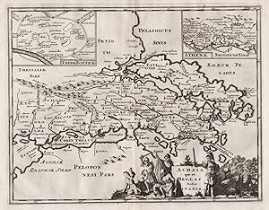
Achaia quae est Hellas hodie Livadia" - Greece / Griechenland / Athens / Athen / Ellada
Verlag: Amsterdam, 1697
Anbieter: Antiquariat Steffen Völkel GmbH, Seubersdorf, Deutschland
Bewertung:
Karte
Blatt-Maße: ca. 22,5 x 31,5 cm. -- Original Kupferstich-Karte von 1697. -- mit hinterlegter Wurmspur im unteren Bildbereich, sonst gut erhalten. -- Original engraved map from 1697. -- with deposited wormhole on the lower part of the map, otherwise in good condition. || Carte gravée de 1697. -- avec trace de ver déposée dans la zone inférieure de l'image, sinon en bon état. || Philipp Clüver war ein deutscher Geograph und Historiker, der starken Einfluss auf die Wiederbelebung der geographischen Wissenschaft in Europa hatte und als Begründer der historischen Geographie gilt. || Philipp Clüver was a German geographer and historian who had a strong influence on the revival of geographical science in Europe and is considered the founder of historical geography. || Philipp Clüver était un géographe et historien allemand qui a eu une forte influence sur la renaissance de la science géographique en Europe et est considéré comme le fondateur de la géographie historique. la Gewicht in Gramm: 10.
-
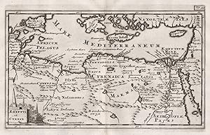
Aegyptus et Cyrene" - Egypt / Ägypten / Egypte / Libya / Libyen
Verlag: Amsterdam, 1697
Anbieter: Antiquariat Steffen Völkel GmbH, Seubersdorf, Deutschland
Bewertung:
Karte
Blatt-Maße: ca. 22,5 x 31,5 cm. Platte: ca. 14 x 21,5 cm. -- Original Kupferstich-Karte von 1697. -- gut erhalten. -- Original engraved map from 1697. -- in good condition. || Carte gravée de 1697. -- en bon état. || Philipp Clüver war ein deutscher Geograph und Historiker, der starken Einfluss auf die Wiederbelebung der geographischen Wissenschaft in Europa hatte und als Begründer der historischen Geographie gilt. || Philipp Clüver was a German geographer and historian who had a strong influence on the revival of geographical science in Europe and is considered the founder of historical geography. || Philipp Clüver était un géographe et historien allemand qui a eu une forte influence sur la renaissance de la science géographique en Europe et est considéré comme le fondateur de la géographie historique. la Gewicht in Gramm: 10.
-
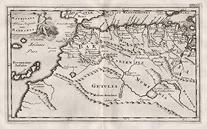
Mauritania et Africa Propria nunc Barbaria" - Morocco / Algeria / Maroc / Algerie / Marokko / Algerien
Verlag: Amsterdam, 1697
Anbieter: Antiquariat Steffen Völkel GmbH, Seubersdorf, Deutschland
Bewertung:
Karte
Blatt-Maße: ca. 22,5 x 31,5 cm. Platte: ca. 14 x 21,5 cm. -- Original Kupferstich-Karte von 1697. -- gut erhalten. -- Original engraved map from 1697. -- in good condition. || Carte gravée de 1697. -- en bon état. || Philipp Clüver war ein deutscher Geograph und Historiker, der starken Einfluss auf die Wiederbelebung der geographischen Wissenschaft in Europa hatte und als Begründer der historischen Geographie gilt. || Philipp Clüver was a German geographer and historian who had a strong influence on the revival of geographical science in Europe and is considered the founder of historical geography. || Philipp Clüver était un géographe et historien allemand qui a eu une forte influence sur la renaissance de la science géographique en Europe et est considéré comme le fondateur de la géographie historique. la Gewicht in Gramm: 10.
-
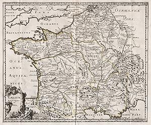
Gallia Antiqua et Nova" - Gallia / Gallien / Gaule / France / Frankreich / Gallier
Verlag: Amsterdam, 1697
Anbieter: Antiquariat Steffen Völkel GmbH, Seubersdorf, Deutschland
Bewertung:
Karte
Blatt-Maße: ca. 30,5 x 37 cm. -- Original Kupferstich-Karte von 1697. -- gut erhalten. -- Original engraved map from 1697. -- in good condition. || Carte gravée de 1697. -- en bon etat. || Philipp Clüver war ein deutscher Geograph und Historiker, der starken Einfluss auf die Wiederbelebung der geographischen Wissenschaft in Europa hatte und als Begründer der historischen Geographie gilt. || Philipp Clüver was a German geographer and historian who had a strong influence on the revival of geographical science in Europe and is considered the founder of historical geography. || Philipp Clüver était un géographe et historien allemand qui a eu une forte influence sur la renaissance de la science géographique en Europe et est considéré comme le fondateur de la géographie historique. la Gewicht in Gramm: 10.
-
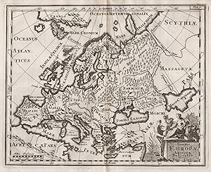
Summa Europae Antiquae Descriptio" - Europe / Europa / continent / Kontinent
Verlag: Amsterdam, 1697
Anbieter: Antiquariat Steffen Völkel GmbH, Seubersdorf, Deutschland
Bewertung:
Karte
Blatt-Maße: ca. 22,5 x 31,5 cm. -- Original Kupferstich-Karte von 1697. -- gut erhalten. -- Original engraved map from 1697. -- in good condition. || Carte gravée de 1697. -- en bon état. || Philipp Clüver war ein deutscher Geograph und Historiker, der starken Einfluss auf die Wiederbelebung der geographischen Wissenschaft in Europa hatte und als Begründer der historischen Geographie gilt. || Philipp Clüver was a German geographer and historian who had a strong influence on the revival of geographical science in Europe and is considered the founder of historical geography. || Philipp Clüver était un géographe et historien allemand qui a eu une forte influence sur la renaissance de la science géographique en Europe et est considéré comme le fondateur de la géographie historique. la Gewicht in Gramm: 10.
-

Hodiernae Belgicae sive Germaniae Inferioris Tabula" - Holland / Nederland / Netherlands / Niederlande
Verlag: Amsterdam, 1697
Anbieter: Antiquariat Steffen Völkel GmbH, Seubersdorf, Deutschland
Bewertung:
Karte
Blatt-Maße: ca. 22,5 x 31,5 cm. -- Original Kupferstich-Karte von 1697. -- gut erhalten. -- Original engraved map from 1697. -- in good condition. || Carte gravée de 1697. -- en bon état. || Philipp Clüver war ein deutscher Geograph und Historiker, der starken Einfluss auf die Wiederbelebung der geographischen Wissenschaft in Europa hatte und als Begründer der historischen Geographie gilt. || Philipp Clüver was a German geographer and historian who had a strong influence on the revival of geographical science in Europe and is considered the founder of historical geography. || Philipp Clüver était un géographe et historien allemand qui a eu une forte influence sur la renaissance de la science géographique en Europe et est considéré comme le fondateur de la géographie historique. la Gewicht in Gramm: 10.
-
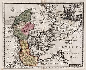
Regni Daniae" - Danmark / Denmark / Dänemark
Verlag: Amsterdam, 1697
Anbieter: Antiquariat Steffen Völkel GmbH, Seubersdorf, Deutschland
Bewertung:
Karte
Blatt-Maße: ca. 22,5 x 31,5 cm. -- Original altkolorierte Kupferstich-Karte von 1697. - gut erhalten. -- Original old colored engraved map from 1697. -- in good condition. || Carte gravée de 1697. -- en bon etat. || Philipp Clüver war ein deutscher Geograph und Historiker, der starken Einfluss auf die Wiederbelebung der geographischen Wissenschaft in Europa hatte und als Begründer der historischen Geographie gilt. || Philipp Clüver was a German geographer and historian who had a strong influence on the revival of geographical science in Europe and is considered the founder of historical geography. || Philipp Clüver était un géographe et historien allemand qui a eu une forte influence sur la renaissance de la science géographique en Europe et est considéré comme le fondateur de la géographie historique. la Gewicht in Gramm: 10.
-

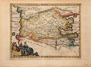
Syriae sive Soriae" - Syria / Syrien / Syrie
Verlag: Amsterdam, 1697
Anbieter: Antiquariat Steffen Völkel GmbH, Seubersdorf, Deutschland
Bewertung:
Karte
Blatt-Maße: ca. 22,5 x 31,5 cm. -- Original altkolorierte Kupferstich-Karte von 1697. -- im unteren Außenrand mit hinterlegter Wurmspur, sonst gut erhalten. -- Original old colored engraved map from 1697. -- with a deposited wormhole on the lower outer margin, otherwise in good condition. || Carte gravée de 1697. -- en bon etat. || Philipp Clüver war ein deutscher Geograph und Historiker, der starken Einfluss auf die Wiederbelebung der geographischen Wissenschaft in Europa hatte und als Begründer der historischen Geographie gilt. || Philipp Clüver was a German geographer and historian who had a strong influence on the revival of geographical science in Europe and is considered the founder of historical geography. || Philipp Clüver était un géographe et historien allemand qui a eu une forte influence sur la renaissance de la science géographique en Europe et est considéré comme le fondateur de la géographie historique. la Gewicht in Gramm: 10.
-
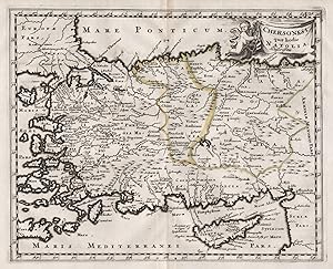
Chersonesi quae hodie Natolia Descriptio" - Turkey / Türkei / Asia Minor / Anatolia / Kleinasien / Cyprus / Zypern
Verlag: Amsterdam, 1697
Anbieter: Antiquariat Steffen Völkel GmbH, Seubersdorf, Deutschland
Bewertung:
Karte
Blatt-Maße: ca. 22,5 x 31,5 cm. -- Original altkolorierte Kupferstich-Karte von 1697. -- am unteren Rand mit 2 kleinen Wurmlöchlein, sonst gut erhalten. -- Original old colored engraved map from 1697. -- with two small wormholes on the lower margin, otherwise in good condition. || Carte gravée de 1697.|| Philipp Clüver war ein deutscher Geograph und Historiker, der starken Einfluss auf die Wiederbelebung der geographischen Wissenschaft in Europa hatte und als Begründer der historischen Geographie gilt. || Philipp Clüver was a German geographer and historian who had a strong influence on the revival of geographical science in Europe and is considered the founder of historical geography. || Philipp Clüver était un géographe et historien allemand qui a eu une forte influence sur la renaissance de la science géographique en Europe et est considéré comme le fondateur de la géographie historique. la Gewicht in Gramm: 10.