
Gesamtpreis (1 Artikel Artikel):
Versandziel:

BOWEN, EMANUEL (107 Ergebnisse)
Direkt zu den wichtigsten Suchergebnissen
Produktart
- Alle Produktarten
- Bücher (73)
- Magazine & Zeitschriften
- Comics
- Noten
- Kunst, Grafik & Poster (4)
- Fotografien
- Karten (30)
-
Manuskripte &
Papierantiquitäten
Zustand
- Alle
- Neu
- Antiquarisch/Gebraucht
Einband
Weitere Eigenschaften
Land des Verkäufers
Verkäuferbewertung
-
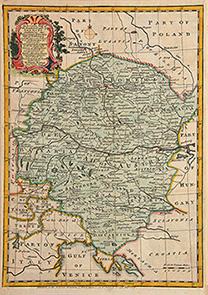
Britannia Depicta Or Ogilby Improved Road Atlas Of England And Wales ( 1720 )
Verlag: Frank Graham, Newcastle, 1970
ISBN 10: 0900409398ISBN 13: 9780900409394
Anbieter: Alexander Books (ABAC/ILAB), Ancaster, ON, Kanada
Bewertung:

Buch
Hardcover. Zustand: Fine. Zustand des Schutzumschlags: Good. Facsimile. 273 Pages Illus. Dust Jacket Shows Wear From Handling With Several Tears.
-

A New & Correct Map of the Netherlands or Low Countries.
Verlag: London c., 1750
Anbieter: Robert Frew Ltd. ABA ILAB, London, Vereinigtes Königreich
Verbandsmitglied: ABA ILAB PBFA
Bewertung:
Karte
34.6 x 42.6 cm. Uncoloured. Copper engraved general map of Belgium and the south of the Netherlands. Two vertical folds. Some light offsetting, otherwise in very good condition.
-
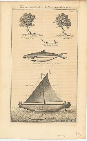
Things remarkable in the Mary-Anne Islands.
Verlag: London ., 1764
Anbieter: Robert Frew Ltd. ABA ILAB, London, Vereinigtes Königreich
Verbandsmitglied: ABA ILAB PBFA
Bewertung:
Kunst / Grafik / Poster
Original uncoloured engraving. Plate dimensions 34 x 20 cm, overall sheet size 40 x 25 cm. Offsetting from text affecting image, generally very good. Engraving of fish, botany and boat of the Marianne Islands. From Harris's, Navigantium atque itinerantium bibliotheca or, a Complete Collection of Voyages and Travel.
-
Von guter Erhaltung. L Sprache: Englisch Gewicht in Gramm: 550 15 x 21 cm. Blattgröße: 18 x 22,5 cm.
-
Map of Middlesex, from Britannia Depicta by Thomas Bowles.
Verlag: London Thomas Bowles 1720, 1720
Anbieter: Harrison-Hiett Rare Books, Richelieu, Frankreich
Verbandsmitglied: ABA ILAB NVVA
Bewertung:

Karte
Copper engraving by Emanuel Bowen published in the pocket road book Britannia Depicta by Thomas Bowles from 1720. This was the first truly pocket sized road book for the traveller based on the surveys of John Ogilby published in large folio format 45 years earlier in 1675. The plates were printed on both sides of the paper, reducing the weight of the volume which required considerable organisation for the process of copperplate printing as the ink required an extensive drying-off period. The notes by John Owen were engraved by Emanuel Bowen on the copperplate surrounding the road maps and also on separate plates. The maps have become commonly known as "Owen & Bowen" maps. The map is set below a decorative cartouche containing the title for the road from London to Bristol with the final part of the road from London to Berwick verso. 190 x 120 mm (7˝ x 4ľ inches).
-

POST-CHAISE COMPANION - AN ACCURATE MAP OF THE COUNTY OF SURREY ; DIVIDED INTO ITS HUNDREDS ; DRAWN FROM SURVEYS, AND ILLUSTRATED WITH VARIOUS ADDITIONAL IMPROVEMENTS : ALSO HISTORICAL EXTRACTS RELATING TO NATURAL HISTORY, MANUFACTURES, TRADE AND PRESENT STATE OF ITS PRINCIPAL T
Verlag: London ca, 1750
Anbieter: Neusser Buch & Kunst Antiquariat, Neuss, NRW, Deutschland
Bewertung:

Kunst / Grafik / Poster
Postreisekarte, Kupferstich mit Grenzcolorit. 2 Cartouchen. 53 x71 cm. auf Leinen gezogen, mit Knickspuren, Karten in den Faltungen tls. gerissen, sonst sauber erh., Schuber stärker berieben. Sprache: Deutschu.
-
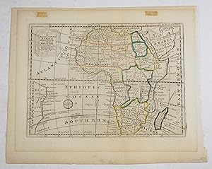
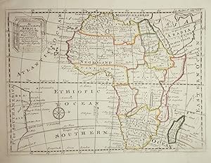
AN ORIGINAL ENGRAVED MAP OF Africa. An accurate map of Africa drawn from the best modern maps & charts and regulated by astronoml. observatns.
Verlag: Bowen 1747, 1747
Anbieter: PROCTOR / THE ANTIQUE MAP & BOOKSHOP, DORCHESTER, Vereinigtes Königreich
Verbandsmitglied: PBFA
Bewertung:
Karte
Original engraved map. Unframed. Engraved survace 18.5 x 13.5 cm. (approx 7 x 5.5 ins.) Overall size 22 x 27 cm. (8.5 x 7 ins.) In very good condition. Some overall tanning and darkening. Two small marks top margin. Good strong impression. An excellent example. With later hand colouring. Map shows mid-eighteenth century political boundaries, cities, and indigenous tribes in Africa.
-

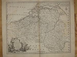
An Accurate map of the North West part of Germany.
Verlag: London: 1756, 1756
Anbieter: Peter Harrington. ABA/ ILAB., London, Vereinigtes Königreich
Verbandsmitglied: ABA ILAB PBFA
Bewertung:
A map of North West Germany including Westphalia & Lower Saxony. Size: 338 x 235 mm Copper engraving. Hand coloured. Very good condition.
-
An Accurate map of the South East part of Germany.
Verlag: London: 1756, 1756
Anbieter: Peter Harrington. ABA/ ILAB., London, Vereinigtes Königreich
Verbandsmitglied: ABA ILAB PBFA
Bewertung:
A map of South East Germany including the Electorate of Bavaria and Bohemia, then a seat of dispute and war between Prussians and Austrians. Size: 250 x 233 mm Copper engraving. Hand coloured. Very good condition.
-

Niederlande - Kupferstichkarte "A new and correct map of the seven united provinces".
Verlag: Ohne Ort und Jahr [London um 1750].
Zustand: -. Teilkolorierte Kupferstichkarte in der Größe von 32,5 x 40,5 cm. Gebräunt und in den Rändern hinterlegt.
-
![Bild des Verkäufers für A new and accurate map of Germany, divided into its circles. [Aus: A Complete System of Geography, 1747] zum Verkauf von Versandantiquariat Hösl](https://pictures.abebooks.com/inventory/md/md31063381105.jpg)
A new and accurate map of Germany, divided into its circles. [Aus: A Complete System of Geography, 1747]
Verlag: William Innys, London, 1747
Karte
Zustand: Befriedigend. Karte aus Bowen's Werk 'A Complete System of Geography' aus dem Jahr 1747, etwas später von Hand grenzkoloriert, auf Karton aufgezogen. Der Karton mit Abbrüchen an den Ecken, die Karte selbst ist gedunkelt und in gutem Zustand ohne Flecken oder Schäden. Titelkartusche rechts oben, links die Würdigung der zuarbeitenden Kartographen: 'In Composing of this map, and those others of the several parts of Germany, We have consulted Hubner, De Lisle, Homan, Le Rouge etc. Besides the most approv'd English maps: The Situations of the principal Cities and Towns being determin'd by Astronomical Observations.' Emanuel Bowen (1694 8 May 1767) was a Welsh map engraver, who achieved the unique distinction of becoming Royal Mapmaker to both to King George II of Great Britain and Louis XV of France. Bowen was highly regarded by his contemporaries for producing some of the largest, most detailed and most accurate maps of his era. He is known to have worked with most British cartographic figures of the period including John Owen and Herman Moll. (Wikipedia) Sprache / Language: en 1 Seiten. ca. 34,4 x 24 cm.
-
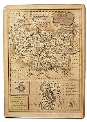
A New and Accurate Map of the South West of Germany. Comprehending the Achbischopricks of Mentz and Treves; the Electroal Palat: of the Rhine; Dutchy of Wirtemberg; Franconia, Swabia, Alsace, Lorrain & c. Drawn from the best Authorities and most approved Maps and Regulated by Astron. Observations. (ca. 1747). Grenzkolorierte Kupferstichkarte 22,5 x 32 cm. Blattgröße 25,5 x 41 cm. Im unteren Drittel ist eine Inset-Karte: Exact Plans of Old and New Brisac or Brisach with their Fortifications and places adjacent. Rechts oben Titelkartusche, daneben graphischer Maßstab (English Miles, German Leagues).- Die Karte ist leicht gebräunt, die Ränder sind gering fleckig, insgesamt wohl erhaltenes Exemplar.
-
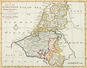
A Map of the Seven United Provinces: with the Dutch Austria and French Netherlands
Verlag: 1770, 1770
Anbieter: Peter Harrington. ABA/ ILAB., London, Vereinigtes Königreich
Verbandsmitglied: ABA ILAB PBFA
Bewertung:
Attractive map of the Netherlands from Gravelines in the West to Embden in the North East and South to Thionville Copper engraving. Hand coloured. Fine condition Size: 27 x 22 cm. (10˝ x 8˝ inches).
-
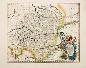
A Correct Map of the North West part of Germany
Verlag: London. c1745, 1745
Anbieter: Peter Harrington. ABA/ ILAB., London, Vereinigtes Königreich
Verbandsmitglied: ABA ILAB PBFA
Bewertung:
Nice map of north western germany. An ornamental cartouche at lower right. From Mr Tindal's Continuation of Rapin's History. Copper engraving. Hand coloured. Fine condition Size: 43 x 35 cm.
-
A Correct Map of the North West part of GERMANY
Verlag: London. c1745, 1745
Anbieter: Peter Harrington. ABA/ ILAB., London, Vereinigtes Königreich
Verbandsmitglied: ABA ILAB PBFA
Bewertung:
A map of the north western portion of Germany. A decorated cartouche at lower left. From Mr Tindal's Continuation of Rapin's History. Copper engraving. Hand coloured. Fine condition, good margins. Size: 43 x 35 cm.
-

A New & Accurate Map of the Netherlands or Low Countries
Verlag: Mr Tindal's Continuation of Rapin's History. c1745, 1745
Anbieter: Peter Harrington. ABA/ ILAB., London, Vereinigtes Königreich
Verbandsmitglied: ABA ILAB PBFA
Bewertung:
Copper engraving. Hand coloured. Size: 43 x 36 cm. (17 x 14 inches).
-
Zustand: Befriedigend. Karte aus Bowen's Werk 'A Complete System of Geography' aus dem Jahr 1747, etwas später von Hand grenzkoloriert, auf Karton aufgezogen. Der Karton mit Abbruch am oberen Eck links, die Karte selbst ist gedunkelt und in gutem Zustand ohne Flecken oder Schäden. Die Rückseite ist teilw. gebräunt fleckig. Titelkartusche rechts oben, einschließlich einer Würdigung der zuarbeitenden Kartographen: 'Drawn from the best Authoritiesand most approved Maps, and Regulated by Astron'l Observations.' Mit einer Einschaltkarte/Stadtplan von Alt Breisach und einem schematischen Plan der Festung Breisach. Emanuel Bowen (1694 8 May 1767) was a Welsh map engraver, who achieved the unique distinction of becoming Royal Mapmaker to both to King George II of Great Britain and Louis XV of France. Bowen was highly regarded by his contemporaries for producing some of the largest, most detailed and most accurate maps of his era. He is known to have worked with most British cartographic figures of the period including John Owen and Herman Moll. (Wikipedia) Sprache / Language: de 1 Seiten. ca. 35,5 x 25,5 cm.
-
48 x 41,5 cm A New & Correct Map of the Netherlands, or Low Countries, hrsg. ca. 1750. Kupferstich, von Emanuel Bowen, Links unten figuralle Kartusche. Bowen Emanuel: um 1720-67. englischer Kartenstecher und Verleger., guter Zustand Sprache: Deutsch Gewicht in Gramm: 550.
-
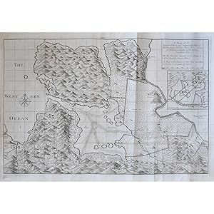
A Plan & Perspective view of the Improved Land of Mingary
Verlag: London, 1734
Anbieter: Bruce Marshall Rare Books, Cheltenham, Vereinigtes Königreich
Bewertung:
Karte
No Binding. Zustand: Very Good. Copper engraved plan inset view of Mingary Castle, compass rose,old folds, reinforced along one fold on verso, overall size 480 x 645mm, London [c.1734] An attractive plan of Mingary in Argyllshire with an inset view of Mingary Castle from the sea. The highly detailed plan is based on the survey of Ardnamurchan by John L. Cowley. It shows hills, forests, rivers, roads, buildings and even tide lines. A higher standard of map was demanded in the eighteenth and early nineteenth century due to the radical changes being made to the landscape, a result of industrialisation, population growth and migration. Trigonometrical surveying had replayed the traverse and sketch methods used prior, leading to a higher standard in accuracy and detail. Mingary Castle is a 14th Century castle with an interesting history. The castle was used as a stronghold for King James IV of Scotland when fighting off the Clan Donald in the late 15th Century. In 1588, one of the ships of the Spanish Armada, named the San Juan de Sicilia, landed on Mull and MacLean of Duart used troops from the ship to aid him in his warring against the MacDonalds of Clanranald and the MacIans of Ardnamurchan. On one occasion, a force from the ship besieged to the castle for three days before withdrawing.
-
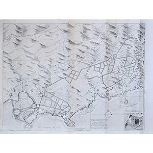
A Map of the Improved Moss and Improveable Bay of Kintra
Verlag: London, 1734
Anbieter: Bruce Marshall Rare Books, Cheltenham, Vereinigtes Königreich
Bewertung:
Karte
No Binding. Zustand: Very Good. Copper engraved map, inset plan showing The Method of Draining the Channel of any Considerable River , compass rose, old folds, small marginal tears repaired on verso, folds reinforced on verso, overall size 655 x 460mm, [c.1734] A scarce map of Kintra in Argyllshire. The highly detailed map is based on the survey of Ardnamurchan by John L. Cowley. It shows hills, forests, rivers, roads, buildings and instruction on draining canals. A higher standard of map was demanded in the eighteenth and early nineteenth century due to the radical changes being made to the landscape, a result of industrialisation, population growth and migration. Trigonometrical surveying had replayed the traverse and sketch methods used prior, leading to a higher standard in accuracy and detail. A strong impression of a scarce map.
-
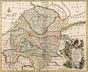
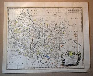
A CORRECT MAP of the South East part of GERMANY. Including the Electorate of Bavaria, Arch.Bishopk. of Salzburg & Kingdom of Bohemia. ALSO, the QUEEN of HUNGARY'S Hereditary Dominions in the Empire; vizt. Austria, Moravia, Styria, Carinthia, Carniola, Trent, Tirol & c. Drawn from the best Authorities, and adjusted by Astronl. Observatns. By Emanl. Bowen
Verlag: London. c1745, 1745
Anbieter: Peter Harrington. ABA/ ILAB., London, Vereinigtes Königreich
Verbandsmitglied: ABA ILAB PBFA
Bewertung:
Map of Bavaria, Bohemia and Austria. Ornamental cartouche at lower right. Emmanuel Bowen was one of the leading English mapmakers of the eighteenth-century, and was cartographer to both the French and English Royal Courts. From Mr Tindal's Continuation of Rapin's History. Copper engraving. Hand coloured. Very good condition; good margins; light stain along the centrefold; some offsetting. Size: 43 x 36 cm.
-
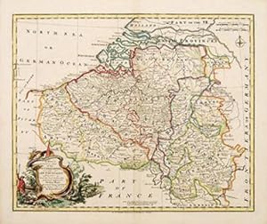
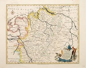
A New & Correct Map of the Netherlands or Low Countries
Verlag: Mr Tindal's Continuation of Rapin's History c1745, 1745
Anbieter: Peter Harrington. ABA/ ILAB., London, Vereinigtes Königreich
Verbandsmitglied: ABA ILAB PBFA
Bewertung:
This attractive map covers modern day Belgium, and northern France, but not Holland, which, according to the map, is 'Part of the seven Provinces'. Ornamental cartouche at lower left Copper engraving. Hand coloured. Fine condition. Size: 48 x 40 cm. (19 x 15˝ inches).
-

A CORRECT MAP of the North West part of GERMANY.
Verlag: London. 1752, 1752
Anbieter: Peter Harrington. ABA/ ILAB., London, Vereinigtes Königreich
Verbandsmitglied: ABA ILAB PBFA
Bewertung:
Attractive map of part of Germany with decorative cartouche at lower left. From Mr Tyndal's Continuation of Mr Rapin's History. Copper engraving. Hand coloured. Fine condition. Margins are slightly brittle. Size: 42 x 34 cm.
-
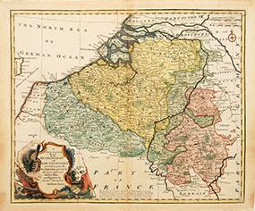
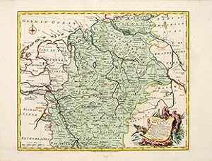
A New & Accurate Map of the Netherlands or Low Countries
Verlag: London. 1752, 1752
Anbieter: Peter Harrington. ABA/ ILAB., London, Vereinigtes Königreich
Verbandsmitglied: ABA ILAB PBFA
Bewertung:
Ornamental cartouche at lower left. This attractive and detailed map covers modern day Belgium, and northern France, but not Holland, which, on the map is called, 'The Seven United Provinces.' Copper engraving. Later colouring. Fine condition, slightly age toned. Size: 43 x 36 cm.
-
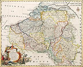
A NEW & CORRECT MAP of the NETHERLANDS OR LOW COUNTRIES DRAWN from the best Authorities and most approved Modern Maps. the whole being regulated by Astronl. Observatns. by Eman: Bowen
Verlag: Mr Tindal's Continuation of Rapin's History. c1745, 1745
Anbieter: Peter Harrington. ABA/ ILAB., London, Vereinigtes Königreich
Verbandsmitglied: ABA ILAB PBFA
Bewertung:
Detailed map of the Netherlands with an ornamental cartouche at bottom left. Emmanuel Bowen was one of the leading English mapmakers of the eighteenth-century, and was cartographer to both the French and English Royal Courts. Copper engraving. Hand coloured. Very good condition. Size: 43 x 35 cm. (17 x 14 inches).
-
A New And Correct Map of the South West Part of Germany, containing the Archbishopricks and Electorates of Mentz (Mainz) and Triers (Trier) (.). Wohl aus E. Bowen: The maps and charts to the modern part of the Universal History.
Verlag: London, Osborne et al., 1766., 1766
Anbieter: Antiquariat am Moritzberg, Hildesheim, NDS, Deutschland
Bewertung:
Teilkolorierte OKuperstichkarte mit Kartusche. 35 x 43 cm (Druckspiegel). 2 Knickfalten; Blatt gering angegraut. Die Abbildung reicht von Zürich bis Düsseldorf, von Straubing bis Clermont. EN.
-
The Harbor of Placentia
Verlag: c. 1748, London, 1748
Anbieter: Alexandre Antique Prints, Maps & Books, Toronto, ON, Kanada
Bewertung:
Karte
Size : 87x137 (mm), 3.43x5.39 (Inches), Hand Colored Very Good, backed on acid free tissue paper for long term preservation.
-
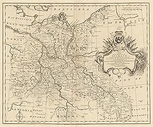
A Correct Map of the North East Part of Germany containing the Electorates. of Saxony and Brandenburg, and the duchies of Silesia, Mecklenburg, Pomerania & c. Drawn from the best Authorities and adjusted by Astron Observations.By Eman Bowen.
Verlag: Emanuel Bowen, Germany, 1730
Anbieter: Antiquariat Reinhold Berg eK Inh. R.Berg, Regensburg, Deutschland
Bewertung:
Karte
Other. Original Kupferstich, unkoloriert erschienen. Dargestellt wird der nordöstliche Teil Deutschlands mit Teilen von Preussen, Polen, Ungarn, Böhmen und Bayern. Die sehr dekorative Kartusche befindet sich auf der rechten Kartenseite mittig. Der Meilenzeiger ist im rechten oberen Eck angebracht und links unten finden wir eine Kompassrose. In ausgezeichnetem Zustand. 345 by 420mm (13˝ by 16˝ inches).
-
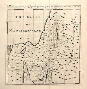
A Map of the Journey in the Wilderness and of the Conquest and Partition of the Land of Canaan, by the Children of Israel according to this History
Verlag: Bowen, Emanuel, London
Anbieter: Argosy Book Store, ABAA, ILAB, New York, NY, USA
Bewertung:
unbound. Map. Uncolored Engraving. Image measures 11 1/4" x 10 3/4" This map of the Holy Land published in the 18th century depicts the region in Biblical times. Extending from the Nile Delta to the Arabian Desert, the map illustrates the journey of the Israelites from Egypt through Sinai and into the Promised Land. Mountains are depicted pictorially. Cities are labeled, as well as the encampments of the Israelites, numbered according to biblical references. The region is divided for the twelve sons of Jacob. Emanuel Bowen (1714-1767) was an English map engraver who served as Royal Mapmaker to George II of England and Louis XV of France. He was well-regarded for his large, detailed, accurate, and overall attractive maps. This map is a lovely look at the expansion of geographic and scientific knowledge that occurred in the colonial era.
-
A Correct Map of the South East part of Germany
Verlag: London. c1745, 1745
Anbieter: Peter Harrington. ABA/ ILAB., London, Vereinigtes Königreich
Verbandsmitglied: ABA ILAB PBFA
Bewertung:
Map of Bavaria, Bohemia and Austria. Ornamental cartouche at lower right. Rivers prominent. From Mr Tindal's Continuation of Rapin's History. Copper engraving. Hand coloured. Very good condition. Good margins. Waterstain at top right edge, not affecting map Size: 43 x 36 cm.

