Gesamtpreis (1 Artikel Artikel):
Versandziel:

BOCAGE, M BARBIE DU, (7 Ergebnisse)
Direkt zu den wichtigsten Suchergebnissen
Produktart
- Alle Produktarten
- Bücher (5)
- Magazine & Zeitschriften
- Comics
- Noten
- Kunst, Grafik & Poster
- Fotografien
- Karten (2)
-
Manuskripte &
Papierantiquitäten
Zustand
- Alle
- Neu
- Antiquarisch/Gebraucht
Einband
Weitere Eigenschaften
- Erstausgabe
- Signiert
- Schutzumschlag
- Angebotsfoto (4)
Land des Verkäufers
Verkäuferbewertung
-
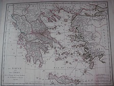
49,0 x 41,5 cm. map "La Grčce et sees Isles pour le Voyage du Jeune Anarcharsis Par M. Barbie du Bocage, 1788, Kupferstich tlw. koloriert, guter-sehr guter Zustand genuine map, Original-Landkarte Sprache: Deutsch Gewicht in Gramm: 550.
-

La Grčce et ses Isles. (Mapa): Pour le Voyage du Jeune Anacharsis
Verlag: [Imp. Benoit Cano], 1788
Anbieter: Librería Miguel Miranda, Lope de Vega n.ş XIX, Madrid, M, Spanien
Bewertung:

Buch
Zustand: Good / Bien. [Paris]: [Imp. Benoit Cano], 1788.- Mapa plegado de 34 x 42 cm.- Ligeramente tostado en la cabecera superior sin afectar el encuadre del mapa. Buen papel y en general buen estado. Livre en français GEOGRAFÍA, GUÍAS Y ATLAS DEL EXTRANJERO.
-
Recueil de Cartes Geographiques, Plans, Vues et Medailles de L'Ancienne Grece, Relatifs au Voyage du Jeune Anacharsis, precede d'une Analyse Critique des Cartes. Nouv. Ed.
Verlag: Paris: Didot Le Jeune (1799)., 1799
Anbieter: Antiquariat Bergische Bücherstube Mewes, Overath, Deutschland
Verbandsmitglied: GIAQ ILAB VDA
Bewertung:
110 S., mit gest. Portr., 1 dplblgr., gefalt., grenzkolor. Generalkarte mit gr. Kartusche gest. von Tardieu u. 38 (von 40) (1 dplblgr.) gest. Karten (einige grenzkolor.), Pl. u. Taf. .(u.a. Explication des medailles). Atlas zu: "J.J.Barthelemy. Voyage du jeune Anacharsis en Grece" Die Taf. num. 3-19, 19bis u. 20-39, Taf 1+2 nicht vorhanden* Lex 8° Ldr. *Einband berieben* schönes Expl. aus der Bibliothek v. Eynatten, Schloss Trips*.
-
Recueil de Cartes Geographiques, Plans, Vues et Medailles de L'Ancienne Grece, Relatifs Au Voyage du Jeune Anacharsis; Precede d'une Analyse Critique des Cartes
Verlag: De Bure, Paris, 1790
Anbieter: Argosy Book Store, ABAA, ILAB, New York, NY, USA
Bewertung:
hardcover. Zustand: very good. Third. 31 copper engraved maps plans and plates with several hand colored in outline, many double page. 42 pages of text, small 4to, full mottled calf; rubbed, spitting along spine, corners bumped, title page stamped. William Short bookplate pasted on flyleaf Paris: De Bure, 1790. Third Edition. Very Good. Great atlas of Ancient Greece, including many classical maps and battle plans.
-
Maps, Plans, Views, and Coins, Illustrative of the Travels of Anacharsis the Younger, in Greece, During the Middle of the Fourth Century, Before the Christian Aera
Verlag: Published by J. Johnson, W. J. and J. Richardson, T. Payne, and others , London, 1806
Karte
, [2 blank] i-vii [1] 1-112 pages, followed by maps and plates [4 blank] pages, portrait Frontispiece, Critical Observations on the Maps of Ancient Greece is by Bocage and is the main text of this volume accompanied by a Note Relative to the Plate No. XIX.* and the Explanation of the Plate of Medals and Coins, coloured fold-out map of Greece and the Grecian Islands at the front (plate 2), plate 1 is not included as published, 37 further plates (39 of 39 as published) , the cover is tatty, evidence of pest damage, the leather has suffered loss, the paper is chipped and worn, peeling away from the boards in places, front and back joints and hinges are split, the front board is detached, the rear board loosely held, the contents are fair to very good, some shading and staining to the edges plates, some pest damage, plate 37 is loose, the book is in fair condition , half bound in calf and marbled paper with gilt ruling front and back, 5 raised bands and gilt decoration to the spine, green morocco labels with gilt titles to the spine quarto 28 x 23 cm Hardback ISBN:
-
Recueil de cartes geographique, plans, vues et medailles de l'ancienne Grece, relatifs au Voyage du jeune Anacharsis, précéde d'une analyse critique des cartes,
Verlag: Paris, Chez de Bure l#ainé, 1788
Buch
4°, blauer Pp. Mit 25 doppelseitigen Karten, XLI Seiten, Buchblock gelockert, Karten teilweise lose. Eine Karte mit Fehlstelle, zwei Karten mit halbseitigem Abriss, eine Karte mit Einriss und Fehlstelle oben, eine Karte mit durchgehendem Einriss Sprache: Deutsch.
-
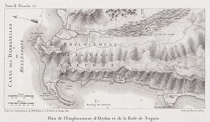
Plan de l'Emplacement d'Abydos et de la Rade de Nagara" - Abydos Hellespont Mysia Dardanelles Canakkale Turkey Türkei map Karte Plan
Verlag: Paris 1782-1822., 1782
Anbieter: Antiquariat Steffen Völkel GmbH, Seubersdorf, Deutschland
Bewertung:
Karte
OriginalKupferstich von 1782-1822 aus der Erstausgabe "Voyage Pittoresque de la Grece" von Marie-Gabriel-Florent-Auguste de Choiseul-Gouffier. -- Blattmasse: ca. 13 x 26 cm. -- gut erhalten. || Original copper engraving from 1782-1822 out of Marie-Gabriel-Florent-Auguste de Choiseul-Gouffier's "Voyage Pittoresque de la Grece". in good condition. || Dies ist ein Original! - Kein Nachdruck! - Keine Kopie! -- This is an original! - No copy! - No reprint! Sprache: Französisch.