Gesamtpreis (1 Artikel Artikel):
Versandziel:

BLAEU, W (201 Ergebnisse)
Direkt zu den wichtigsten Suchergebnissen
Produktart
- Alle Produktarten
- Bücher (137)
- Magazine & Zeitschriften
- Comics
- Noten
- Kunst, Grafik & Poster (14)
- Fotografien
- Karten (49)
-
Manuskripte &
Papierantiquitäten (1)
Zustand
Einband
Weitere Eigenschaften
Gratisversand
Land des Verkäufers
Verkäuferbewertung
-

Zustand: Good. Used book that is in clean, average condition without any missing pages.
Mehr Angebote von anderen Verkäufern bei ZVAB
Gebraucht ab EUR 5,72
-

Judaism : Post Biblical and Talmudic Period
Verlag: Macmillan Publishing Company, Incorporated, 1954
ISBN 10: 0672603446ISBN 13: 9780672603440
Buch
Zustand: Good. Presumed 1st as edition not stated. Former library book; may include library markings. Used book that is in clean, average condition without any missing pages.
-
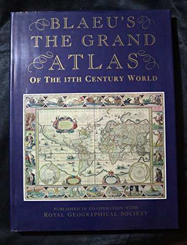
Grand Atlas of the Seventeenth Century World
Verlag: London, Studio, 1990
ISBN 10: 1851704000ISBN 13: 9781851704002
Buch
Befriedigend/Good: Durchschnittlich erhaltenes Buch bzw. Schutzumschlag mit Gebrauchsspuren, aber vollständigen Seiten. / Describes the average WORN book or dust jacket that has all the pages present.
-
SEA CHART OF THE COAST OF DUNKIRK
Verlag: c.1640, Amsterdam, 1640
Anbieter: Second Story Books, ABAA, Rockville, MD, USA
Bewertung:

Karte
Antique map of the coast of Dunkirk from Willem Blaeu and his son, Joan Blaeu--the seventeenth century's most widely known cartographic publishers. Copper engraving printed on paper. Moderate age toning with a few partial tears (not examined out of frame). Frame measures 28 1/8 in x 18 1/8 and has a few scrapes. Map measures 27" x 17". LD Consignment. The map based on a previous chart prepared by Pieter Codde, a sea captain from Enkhuizen in Holland, shows the coast from Dunkirk to Gravelines and beyond with inset at lower right corner of Calais (partially disrupted due to framing). 1367817. FP New Rockville Stock.
-

Tabula Islandiae Auctore Georgio Carolo Flandro.
Verlag: c.1630, Amsterdam, 1630
Anbieter: Alexandre Antique Prints, Maps & Books, Toronto, ON, Kanada
Bewertung:

Karte
Zustand: Very Good. Willem Blaeu map of Iceland, beautifully hand coloured, blank verso. , Size : 382x499 (mm), 15.04x19.65 (Inches), Hand Colored.
-
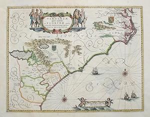
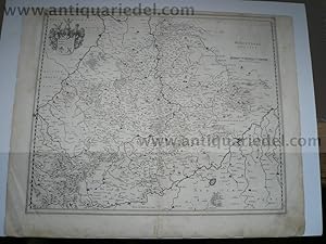
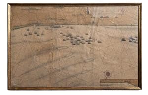
Amsterdam, vers 1630-40. 50X38 cm (sans les marges). Carte des côtes de la Virginie et de la Floride avec limites des possessions anglaises et françaises, rehaussée en couleurs ŕ l époque. Second état de cette rare carte publiée pour la premičre fois en 1620. Papier uniformément bruni, mais sans tache, plié par le milieu (la carte était montée sur onglet ŕ l origine et comporte deux pages de texte en allemand au verso).
-
Virginiae partis australis, et Floridae partis orientalis
Verlag: Amsterdam, 1640
Anbieter: Antipodean Books, Maps & Prints, ABAA, Garrison, NY, USA
Verbandsmitglied: ABAA ANZAAB ESA ILAB
Bewertung:
Zustand: Very good condition. Important early map exhibiting the disputes of England and France over land in the new world, showing the southeastern portion of the United States stretching from 'Chesapeack Bay' in the north to the area of present day Georgia in the south. With the British coat of arms placed near Virginia, and the French coat of arms near the "Apalatcy Montes" and an imaginary lake. Based on a Mercator-Hondius map of 1606, with changes such as a better proportioned Outer Banks, and, for the first time on a printed map, Newport News is shown as Newport Nesa. Handsome original color, ornate cartouche with native American figures; French text on the verso. Image size: 19 3/4 x 15 1/4". Paper size: 23 x 20". The South-East in Early Maps 41 - 'the most correct map of this area yet to appear'; KOEMAN: Bl 22.
-

Damals. Geschichten aus der guten, alten Zeit
Verlag: Gondrom Verlag GmbH, 1997
ISBN 10: 3811215531ISBN 13: 9783811215535
Anbieter: Versandantiquariat Felix Mücke, Grasellenbach - Hammelbach, Deutschland
Bewertung:

Buch
Gebundene Ausgabe. Zustand: Akzeptabel. Artikel stammt aus Nichtraucherhaushalt! BQ4652 Sprache: Deutsch Gewicht in Gramm: 635.
-
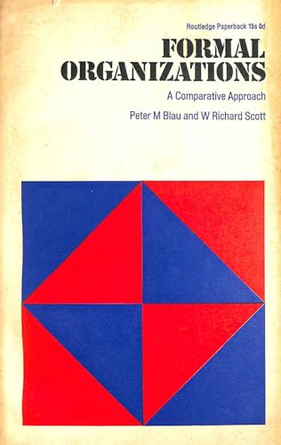
Formal organizations. A comparative approach
Verlag: Routledge, London, 1970
ISBN 10: 071004657XISBN 13: 9780710046574
Buch
Softcover. Zustand: Gut. xiv, 312 p. w/ index. Size: 210 x 150 mm.
-
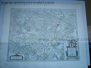
Mansfeldia Comitatus. Auctore Tilemanno Stella Sig.
Verlag: Amsterdam, Blaeu ca.1640., 1640
Altkolorierte Orig.-Kupferstichkarte im Format ca. 41 x 49 cm. + Papierrand. Im unteren Teil leicht braunfleckig. Sonst sauber u. gut erhalten.
-
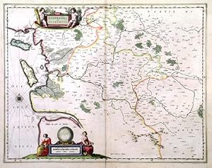
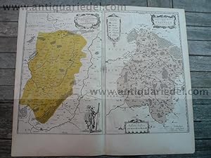
XAINTONGE ET ANGOUMOIS . Map of the greater area from Ile de Ré, La Rochelle, Ile d Oléron and Gironde inland to Angoulęme. Two figurative cartouches.
Verlag: Willem & Joan Blaeu 1639, 1639
Karte
39x50cm. Latin text verso. Original outline colour. Excellent condition. Latin text verso with contemporary ms annotations.
-
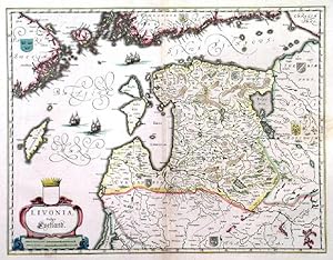
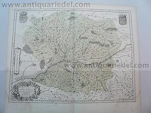
LIVONIA, VULGO LYEFLAND . Highly decorative map of Latvia and Estonia with cartouche and sailing ships.
Verlag: Willem & Joan Blaeu 1639, 1639
Karte
38x49cm. Latin text verso. Original outline colour. Excellent condition.
-
India quae Orientalis dicitur, et Insvlae Adiacentes.
Verlag: Amsterdam, 1635
Anbieter: Alexandre Antique Prints, Maps & Books, Toronto, ON, Kanada
Bewertung:
Karte
Zustand: Excellent. State 2, 1635 German edition. "This extremely rare map is the first and most important derivative of John Smith's mao if Virginia originally published in 1612. Through the purchase of this plate by Willem Jansz. Blaeu in 1629 and its subsequent extensive publication for forty-two years, word of the English in Virginia became known throughout Europe. It is slightly larger than its parent, although more attractively engraved. Taken from the first state of the Smith, it continues the coastlines where the former had left them vague."-Burden 193, Size : 380x493 (mm), 15x19.375 (Inches), Original Hand Coloring.
-
Formal Organizations: A Comparative Approach
Verlag: Routledge & Kegan Paul, 1963
Anbieter: World of Rare Books, Goring-by-Sea, SXW, Vereinigtes Königreich
Bewertung:
Zustand: Good. 1963. First Published. 312 pages. Blue jacket over green cloth with gilt lettering. Visible pencil annotations throughout. Pages are mildly tanned throughout. Text is clear. Binding remains firm. Boards have mild edge-wear with bumping to corners. Light crushing to spine. Gilt lettering remains bright and clear. Unclipped jacket. Panels have light edge wear with tears and creasing.
-
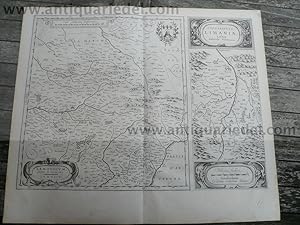
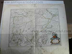
Piemonte et Monferrato
Verlag: Amsterdam, chez Jean&Corneille Blaeu, 1640,, Amsterdam, 1640
Anbieter: Libreria Antiquaria Pregliasco, Torino, Italien
Bewertung:
Zustand: molto buono. Incisione originale in rame (mm 420 x 525 e grandi margini) abilmente colorata da mano coeva, testo in lingua francese al verso. Titolo entro cartiglio circondato da figure allegoriche in alto a destra. Elegante carta geografica del Piemonte e del Monferrato tratta da "Le Theatre du Monde ou Nouvel Atlas" edizione francese del 1640. Conosciuta come ?carta del falconiere?, per il cartiglio. Esemplare ben conservato arricchito da coloritura coeva. KOEMAN C., Atlantes Neerlandici [.], Amsterdam 1967-71, vol. I, pp. 160, scheda Bl 35 A / (2). Book.
-
Zustand: Fair. This is an ex-library book and may have the usual library/used-book markings inside.This book has hardback covers. Book contains pencil markings. In fair condition, suitable as a study copy. No dust jacket. Re-bound by library. Please note the Image in this listing is a stock photo and may not match the covers of the actual item,650grams, ISBN:
-
Deutschland vor drei Jahrhunderten. Seine Städte, Flüsse u. Wälder betrachtet. M. e. nachw. v. C. Broekema.
Verlag: (Gütersloh) Bertelsmann (), 1971
4°. M. zahlr. Ktn u. Abb. 300 S. OPp. m. OPp.-Schuber. Sprache: Deutsch.
-
Hardcover. Zustand: very good. Picardia, map, Blaeu anno 1660 Coppermap, edited by G Blaeu, ca. anno 1660, no text on verso, size of the leaf: 40 x 55 cm., little waterstained, foxed.
-
Hardcover. Zustand: very good. Aardenburg-Ysendijck, Zeeland, Blaeu anno 1640, townbooks, dutch lanquage on verso, size of the leaf: 43x62 cm.
-
Hardcover. Zustand: very good. Bituricum ducatus, Duche de Berri, map, 1640, Blaeu J. Coppermap, edited by the Blaeu Family, anno 1640, german text on verso, size of the leaf: 46x54 cm., no cracs, little brownish.
-
Hardcover. Zustand: very good. Nivernois,ducatus,anno 1650, map, Blaeu Coppermap, edited by Blaeu Family, anno 1650, "NIVERNIVM DVCATVS. Gallice DVCHE DE NEVERS.", german text on verso, printed on thick paper, clean map, no cracs. size of the leaf: 46 x 54 cm.
-
Hardcover. Zustand: very good. Coppermap, edited by Joan Blaeu, in his townbooks, anno 1649, size of the leaf: 49x62 cm., latin text on verso, restored crac on below margin (in the view).
-
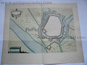
Hardcover. Zustand: very good. Büderich (BVRICK)-Wesel, anno 1700, Grundriss, Blaeu, Grundriss der Stadt, Blattmaß: 50x30 cm., Plan: 34x23 cm. Referenz: Fauser, Nr. 2126, lat. Rückentext. Büderich ist seit 1975 ein Ortsteil der Stadt Wesel, der zusammen mit dem Ortsteil Ginderich den Stadtteil Büderich mit seinen 6.227 Einwohnern (30. Juni 2006) bildet.
-
Hardcover. Zustand: very good. Wirtenberg Ducatus, anno 1640, Blaeu, Karte Wirtenberg Ducatus. Blattmaß: 46x58 cm., Württemberg mit angrenzenden Gebieten zwischen Heidelberg, Schwäbisch Hall, Lauingen / Donau, Memmingen, Villingen / Schwarzwald, Freiburg und dem Rhein von Straßburg bis Mannheim, mit Stuttgart im Zentrum der Karte. Etwas fingerfleckig, kleinere Randläsuren, an den Rändern kleinere Reparaturen.
-
Stift Hirschfeld, anno 1650, Blaeu, altkoloriert, dt. Rückentext
Verlag: Blaeu W.+J.,Atlases,Maps,Townboo
Hardcover. Zustand: very good. Stift Hirschfeld, anno 1650, Blaeu, altkoloriert, franz. Rückentext Kupferkarte, verlegt bei Blaeu, Amsterdam, anno 1650, Blattmaß: 49x60 cm., Mittelfalz etwas geknittert; ansonsten guter Erhaltungszustand, breitrandig.
-
Hardcover. Zustand: very good. Anjou, anno 1640, Blaeu map Coppermap, edited by the Blaeu family, anno 1640, german text on verso, little waterstained, size of the leaf: 46x54 cm.
-
Hardcover. Zustand: very good. Vermandois/Capelle, 2 maps, Blaeu anno 1640 Title: Descriptio Veromanduorum . . . Gallice Vermandois [and] Gouvernement de la Cappelle . . . Map Maker: Willem Janszoon Blaeu Place / Date: Amsterdam / 1640 A nice pair of decorative regional maps on a single sheet. The Vermandois map is centered on the Oyse and Somme Rivers, and shows Chatelet, Beaurevoir, S. Quintin , Preone, Lafere, Channi and Noyon, amoung other larger towns in the region. The Cappelle map is centered on the Oyse and includes Vervins, La Cappelle, Aubanton and Marle, amoung others. Both with title carouches and additional embellishments. German lanquage on verso, size of the leaf: 46x54 cm., little waterstained, no cracs.
-
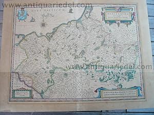
Hardcover. Zustand: very good. Please read german textKupferkarte, verlegt bei G. Blaeu, anno 1650, dt. Rückentext: "Das Hertzogthumb Meckelnburg" , alt koloriert, etwas gebräunt, untere Mittelfalz alt hinterlegt, min. Randläsuren. Blattmaß: 46x56 cm.
-
Hardcover. Zustand: very good. Lemovicum-Limosin, Limaniae, anno 1650, Blaeu Willem Janszoon Blaeu: Lemovicum - Lymosin (and) Topographia Limaniae Acutore Gabriele Simeoneo. Size of the leaf: 46x54 cm., german text on verso, good print, no cracs. Decorative map of the Limosin and Limoge region, with decorative cartouches. Large inset of the Elaver River region.
-
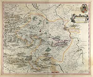
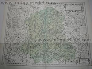
Bavaria Ducatus, anno 1665, Blaeu J., Atlas Major, altkoloriert,
Verlag: Blaeu W.+J.,Atlases,Maps,Townboo
Hardcover. Zustand: very good. Bavaria Ducatus, anno 1665, Blaeu J., Atlas Major, altkoloriert, span. Rückentext, Blattmaß: 64x52 cm. Das Blatt ist stark wasser-und sporenfleckig. Die detaillreiche Karte zeigt das Herzogtum Bayern, das Gebiet zwischen den Flüssen Lech, Donau, Inn-Salzach und Traun mit den Alpen im Süden. Die Karte wird begrenzt durch die Ortschaften Füssen , Landsberg und Augsburg im Westen, Donauwörth, Regensburg und Passau im Norden, Wels und Salzburg im Osten sowie Zell am See und Innsbruck im Süden. Rechts unten große, dekorative Titelkartusche "Bavaria Ducatus / Per Ger. Mercatorem" , auf der Kartusche sitzende weibliche Figur mit bayrischem Wappen. Darunter Meilenanzeiger (Milliaria Bavarica). Links daneben Verlegerhinweis "Apud Guiljelmum Blaeu.".

![Bild des Verkäufers für VIRGINIAE PARTIS AUSTRALIS, ET FLORIDAE PARTIS ORIENTALIS, INTERJACENTIUMQ[UE] REGIONUM NOVA DESCRIPTIO. zum Verkauf von Librairie de l'Univers](https://pictures.abebooks.com/inventory/md/md12972629908.jpg)