Gesamtpreis (1 Artikel Artikel):
Versandziel:

BELFIELD,H CONWAY (2 Ergebnisse)
Direkt zu den wichtigsten Suchergebnissen
Produktart
- Alle Produktarten
- Bücher (2)
- Magazine & Zeitschriften
- Comics
- Noten
- Kunst, Grafik & Poster
- Fotografien
- Karten
-
Manuskripte &
Papierantiquitäten
Zustand
- Alle
- Neu
- Antiquarisch/Gebraucht
Einband
- alle Einbände
- Hardcover
- Softcover
Weitere Eigenschaften
- Erstausgabe
- Signiert
- Schutzumschlag
- Angebotsfoto
Land des Verkäufers
Verkäuferbewertung
-
Handbook of the Federated Malay States.
Verlag: London: Edward Stanford, 1904, 1904
Anbieter: Peter Harrington. ABA/ ILAB., London, Vereinigtes Königreich
Verbandsmitglied: ABA ILAB PBFA
Bewertung:

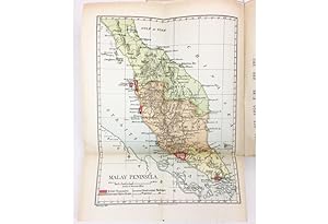
Second edition, first impression, updated from the 1902 first edition with new statistical data, and pleasingly with the fragile maps in well-preserved condition. This informative guide, weighted toward economic affairs, reflects the centrality of Malaya to the industrial health of the British Empire and the opportunities available to overseas investors. Following the creation of the Federated Malay States in 1896, Sir Henry Conway Belfield (1855-1923) was appointed the first commissioner of lands and mines. With his legal and linguistic expertise, he served as resident in three of the Malay states between 1901 and 1912, before being appointed governor of the East Africa Protectorate. Provenance: with the 1906 ownership signature of L. B. Greig on the front free endpaper. In a 1909 directory, Greig is listed as the co-owner of a 650-acre rubber plantation in Selangor. He has made some pencilled economic notes on pp. 165-7 and the final leaf. These include some production estimates for the Perak Kongsi Coconut Company; in 1916, Greig (as the trustee of several debenture-holders) was involved in a civil appeal case concerning Perak Kongsi. A 1906 map of British Malaya, compiled for Sir Frank Swettenham's guide to the country, is loosely inserted. Octavo. Original boards, black cloth backstrip, front cover lettered in black. With 5 folding maps (4 colour), the largest unfolding to 610 x 460 mm, 7 half-tone plates. Boards lightly soiled, backstrip and front inner hinge professionally repaired, maps bright with the usual small stub tears, two slightly crossing the neatline and repaired with Japanese tissue, touch of foxing internally. A very good copy.
-
Handbook of the Federated Malay States Second Edit
Verlag: London: Edward Stanford, []., 1904
Anbieter: Antiquariat Dasa Pahor GbR, München, Deutschland
Bewertung:

Buch
8°: vi, 174 pp., plus 5 folding maps (4 coloured) on thin paper and 7 photographic plates, bound in original printed card covers with brown cloth spine (Good, text with some sporadic marginal foxing and some folding to some corners, some underlining in pencil; Map #1 (Malay Peninsula) with small tear near hinge with no loss closed by old repair; Map #2 (Perak) with large tear through much of upper-right corner with no loss partially closed with old repairs, some creasing; Map #5 (Pahang) with marginal tear at hinge with no loss closed with old repair; covers lightly toned with light edge-wear and faint abrasions MALAYSIA: Handbook of the Federated Malay States Second Edition. Scarce the definitive official overview of the Federated Malay States at the beginning of the 20th Century, during the rubber and tin boom; richly illustrated with 5 folding maps and 7 photographic plates, by Sir H. Conway Belfield, the British Resident in Selangor.The Federated Malay States (FMS) was a British Protectorate on the Malay Peninsula formed in 1895 with the joining of the four hitherto independent kingdoms of Perak, Selangor, Negeri Sembilan and Pahang. The FMS was distinct from the British Crown Colony of Straits Settlements (Singapore, Penang, Malacca and Dinding) and the 'unfederated' states of Perlis, Kedah, Kelantan, Terengganu. While the chief British official of the protectorate, the Resident General, in Kuala Lumpur, possessed broad powers over the economy, military and external affairs, the sultans of each constituent state maintained considerable autonomy over internal affairs. The FMS existed until 1946, wheended and expanded, eventually becoming the modern independent nation of Malaysia in 1963.The present work is the finest and most authoritative general overview of the FMS made during the protectorate's early period, which was also a time of great prosperity and expansion brought about the rubber and tin boom. The work was authored by Sir Henry Conway Belfield, who then served as the Resident (chief British official) in Selangor. The work has much of the feel of an almanac, packed with intriguing information, but is better-written and of a more coherent format than most works of its kind. Belfield, an erudite Oxfordian and highly competent administrator, was able to use his official position to gain access to the best sources, intelligence which he lays out in a manner quite pleasing to the reader. All considered, the Belfield's Handbook is a seminal source on Malaysian history during this critical period.The text is divided into five parts: Part I is a general overview of the Federated Malay es (pp. ); Part II concerns Perak (pp. 33-66); Part III covers Selangor (pp. 67-84); Part IV features Negeri Sembilan (pp. 85-94) and Part V showcases Pahang (pp. 95-142). Each part features well-ordered sections detailing various aspects of the each jurisdiction's official establishment; topography; boundaries; geology; climate; demographics (the 1901 Census shows that the FMS had a total population of 665,000); history; military establishment; economy (especially the all-important rubber and tin industries, as well as the agrarian sector); the entertaining 'Hints to New Arrivals': transportation (the FMS then possessed 396.25 miles of railway lines); as well as other curious matters. Importantly, each section features its own fine folding map, from the best and most recent sources, variously printed by the London firm of Waterlow & Sons or the British Army's Ordnance Survey Office in Southampton. The maps are as follows:1. Malay Peninsula (London: Waterlow & Sons), printed in full colour, 29.m.2. Alfred , Chief Surveyor, Map of Perak 1901 (Southampton: Ordnance Survey Office, 1901), highly detailed official topographical survey, 61 x 47 cm.3. Selangor 1902 (Southampton: Ordnance Survey Office, 1901), coloured agricultural (green) and mining areas (blue), 34.5 x 27.5 cm.4. Sketch Map of Negeri Sembilan (Southampton: Ordnance Survey Office, 1901), printed in red and black, 41.5 x 31 cm.5. Map of Pahang Federated Malay States (Southampton: Ordnance Survey Office, 1901), printed in red and black, 36 x 31 cm.Additionally, the work is augmented by seven full-page photographic plates depicting: a railway station; tin mine; the Perak River; 2 plates of limestone cliffs with railway lines at Kinta; Government Offices in Kuala Lumpur; and the Public Gardens at Kuala Lumpur. The work also features three appendices. The first, concern the shipping lines and routes. The second, provides hints for English planters in Malaya. The third, describes the Straits Settlements, Britain's Crown Colony on t Malay Peninsula (inuding Georgetown, Malacca and Singapore). SEE OUR WE PAGE FOR A LONGER DESCRIPTION.