Gesamtpreis (1 Artikel Artikel):
Versandziel:

Blaue (Mehr als 156.000 Ergebnisse)
Direkt zu den wichtigsten Suchergebnissen
Produktart
- Alle Produktarten
- Bücher (120.817)
- Magazine & Zeitschriften (237)
- Comics (136)
- Noten (567)
- Kunst, Grafik & Poster (2.949)
- Fotografien (183)
- Karten (1.216)
-
Manuskripte &
Papierantiquitäten (30.616)
Zustand
Einband
Weitere Eigenschaften
Gratisversand
Land des Verkäufers
Verkäuferbewertung
-
Illustrirte Zeitung Leipzig Nr.5037 vom Mai 1944, mitsamt dem Gemäldezyklus "Die 4 Tageszeiten" von Willy Kriegel: 4 Originale, in kleinerer Fassung 1943 ff
Verlag: Leipzig, J.J.Weber Verlag,, 1944
Anbieter: Galerie für gegenständliche Kunst, Kirchheim unter Teck, Deutschland
Bewertung:

Buch Erstausgabe
(noch zu Nr.12336:) - "Willy Kriegel und seine Tageszeiten", vierseitiger Bildbericht von Dr.Kurt Karl Eberlein, mit Fotoaufnahme "Professor Willy Kriegel im Atelier bei der Arbeit am "Tageszeitenzyklus", zwei ganzseitigen Farbwiedergaben "Abend" und "Nacht", Schwarzwald-Landschaften aus dem "Tageszeiten-Zyklus" von Willy Kriegel, Große Deutsche Kunstausstellung München 1943" und drei weiteren Wiedergaben von Kriegel schen Zeichnungen: " München, das durch seine großen Kunstausstellungen wieder nach des Führers Willen der zur Stadt der deutschen Kunst wurde, hat auch dem deutschen Volke den Dresdner Künstler bekannt gemacht, den die Kunstkenner längst beachteten und kannten. Ein Bilderzyklus der "Vier Jahreszeiten" auf der Großen Deutschen Kunstausstellung1943 war der große Erfolg des sächsischen Meisters. Der Künstler, der im Kriege in einen stillen, hoch gelegenen Haus am Schluchsee im badischen Schwarzwald sein Heim gefunden hatte, hat in den vier leuchtenden Landschaften "Morgen", "Mittag", "Abend" und "Nacht" die badische Schwarzwaldlandschaft, die durch Hans Thoma und andere badische Maler in die deutsche Kunst eingegangen war, in vier Gedichte verwandelt. Die vier Symphonien in Grün, Blau, Rosa, Silber, ganz von dem Lichtglanz des Himmels erfüllt, vier Sätze eines Schwarzwaldmotivs, das Schluchsee heißt, klingen vor uns diese badischen Landschaften auf, Gleichnisse des Tages, des Lichtes, der Seele, des Lebens, voll von jenem höheren Frieden, den nur die Gottnatur den Schauenden, Fühlenden, Dankenden schenkt. Man beachte, wie nordisch Prof.Kriegel die Blickbühne baut, wie er den Höhenraum sucht - im Gegensatz zum Alemannen, der den ostisch geschlossen Tiefenraum des See- und Waldwinkels bevorzugt - wie er alles dem Lichterlebnis unterordnet, das den Farbbau bestimmt. Vor allem aber beglückt es, wie in Willy Kriegels Werk die Klein- und Feinwelt der Natur zur Kunstwelt des Bildes geworden ist, die für den Maler wie für den Beschauer doch immer das Letzte und Höchste sein wird." - / Bildchronik des Monats (insgesamt elf Fotoabbildungen, u.a.: "Arbeiter und Arbeiterinnen eines lettischen Betriebes bei einem Betriebsappell; sie hören aufmerksam den Ausführungen des ersten Ritterkreuzträgers der lettischen SS-Freiwilligen-Legion, SS-Standartenführer Voldemar Veiß, zu; Generalgouverneur Dr. Frank und Professor Dr.Kümmel, der Direktor der Staatlichen Museen in Berlin, bei der Besichtigung einer kürzlich eröffneten Ausstellung in Krakau, die japanische Drucke der Malerei und der Holzschnittkunst zeigt; Karl Henkell, Betriebsführer der Sektkellerei Henkell & Co., erlag seinen während eines Bombenangriffs erlittenen Verletzungen; Professor Ernst Rüdin, ein sehr verdienstvoller Forscher auf dem Gebiet der Rassenhygiene, beging am 19. April seinen 70. Geburtstag; Generalmusikdirektor Prof.Dr. Hans Pfitzner, einer der anerkannt großen Komponisten der Gegenwart, wurde am 5. Mai 75 Jahre alt") / Wehrpolitische Chronik vom 24. März bis zum 30. April (Der Kampf im Osten, der Luftkrieg - "war schon im März die deutsche Luftwaffe gegen die britisch-nordamerikanischen Terrorangriffe äußerst erfolgreich, indem sie 1234 Feindmaschinen, in der überwiegenden Mehrzahl viermotorige Bomber, abschoß, so ist mit der Steigerung der feindlichen Lufttätigkeit im April auch eine Steigerung der deutschen Verteidigungskraft parallel gegangen; sie konnte in diesen Monat 1392 britisch-nordamerikanische Terrorflugzeuge abschießen, und zwar 1264 viermotorigeBomber und 266 Jagdflugzeuge. Dementsprechend ist auch für die britisch-nordamerikanischen Luftstreitkräfte der Ausfall an fliegendem Personal sehr hoch; er beträgt für den April allein fast 11.000 Mann. . "/ Diplomatische Nachrichten / Kulturchronik. - Später Kriegsdruck, Erstausgabe in guter Erhaltung (Einband etwas stockfleckig, sonst gut) Versand an Institutionen auch gegen Rechnung Sprache: Deutsch Gewicht in Gramm: 2000.
-
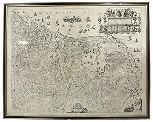
An exceptional pair of Blaeu Table Globes
Verlag: Amsterdam, Willem Jansz. Blaeu 1602 (published after 1621), 1602
Anbieter: Antiquariaat de Roo, Zwijndrecht, Niederlande
Bewertung:

A very rare set of globes, 9 inch / 23cm, with an overall height of 38 cm, Amsterdam, dated 1602, but published after 1621. In their original stands with circular wooden horizon rings, covered with printed paper, supported by four legs and brass meridian rings supported by a single column. The terrestrial and celestial globes are made up of a set of 12 engraved gores, heightened in gold and Arctic ice caps, printed on paper and mounted on a plaster sphere of papier maché. Each sphere is mounted in a graduated brass meridian ring, with the production number stamped on the back of the ring. The hour circles are renewed. Both globes are mounted on four-legged ebonized oak Dutch stands, which support the horizon ring. The legs are connected by two crossbeams, which support a circular base plate with central support for the meridian ring. The horizon rings are covered with printed paper. With usual defects: paper equinoctial tables present gaps that are filled and restored; small splits along gores; several partially deleted entries; on the globe, the date 1602 and the text of the cartouche in America, are illegible ; small scattered spots, but in general in good condition for such an early globe pair, of which presently only 19 pairs are recorded. These 9-inch globes are among the rarest since very few copies of them are known to exist, in comparison with the smaller or larger globes of Blaeu (4, 6, 13.5, and 26 inches). Blaeu's terrestrial globes were highly valued and were much in demand, because of the care with which they had been prepared, because of the efforts to give the latest information on discoveries, and because of the loxodromic lines that made them of special value to navigators. Willem Janszoon Blaeu (1571 1638) started "one of the most successful publishing houses of the seventeenth century" (Dekker). Originally trained in astronomy, he quickly became a leading maker of maps, atlases and instruments. At the time the Low Countries hosted the best cartographers in Europe, and Blaeu produced ever more accurate and more beautiful globes, spurred by his rivalry with fellow Dutch cartographer and publisher Jodocus Hondius. Blaeu s globes were luxury items for wealthy and intellectual merchants and nobility, who benefited from Blaeu s access through the Dutch East India Company to the latest navigational discoveries and geographical information. Willem Jansz Blaeu collected information that Dutch mariners gathered from around world and brought back to Amsterdam. Crews were instructed to record information about the lands they visited and the skies they saw. Blaeu incorporated these observations in maps and globes. Through his web of contacts and assiduous research, he was also able to obtain the most recent information about the latest discoveries in the western hemisphere and the South Pacific, where Dutch explorers were particularly active at the time. Since the globe was published after 1618, Blaeu was able to include the discoveries made by Henry Hudson in his attempt to find a passage to the East Indies. He also included recent Pacific discoveries of the celebrated voyages of Willem Cornelis Schouten and Jacob Le Maire, who both traversed the South Pacific and the Atlantic. The findings of Schouten and Le Maire in the Tierra del Fuego region are also incorporated. The Strait of Le Maire is drawn and the hypothetical southern continent is labeled "Terra Australis Incognita Magalanica". Olivier van Noort s track is drawn and labelled. His route is indicated with a broken line and the words: "Navigationis Olivierij ductus" (several times). There are various decorative features, such as animals on the different continents, many ships on the high seas and allegorical and mythical figures around the cartouches. The nine-inch globe is not just a smaller version of the one published in 1599. Drawings of animals and people do often correspond to those on the earlier globe, but Blaeu made several significant changes. The west coast of North America is drawn differently, and the river system of Brazil is altered. The hypothetical southern continent is labelled: Terra Australis Incognita Magallanica. There are nine ocean names in handsome curling letters: Mare Congelatum, Mare Atlanticum, Oceanus Aethiopicus, Mare Arabicum et Indicum, Mare di India, Oceanus Chinensis, Mar del Zur, Mare Pacificum, Mar del Nort. Willem Blaeu, always eager to display the latest discoveries, traced the route of Van Noort s route with a broken line. The findings of the voyage of Schouten and Le Maire in the Tierro del Fuego region are included, despite the 1602 date (names: Fr. Le Maire, Mauritius, Staten Landt, C.Hoorn, I.Barneveltij). Publication : According to Peter van der Krogt, the following states are known: Terrestrial, First state: 1602 (no known examples). Second state, c1618-1621 (no known examples). Third state: 1602, but c1621 (the present example). All the states are dated 1602 but the second state must have been published after 1618, since it includes the discoveries of Schouten and Le Maire (1615 1617), but not the name "Blaeu". Elly Dekker makes no distinction between the different states. The third state can be divided into states 3a and 3b. All globes have a different production number, some of which are illegible today. This terrestrial nine-inch globe is marked with "fabr. nr. 4". Celestial: First state: 1602 (known in a catalogue record but no known example surviving). Second state: presumably published after 1621. All 30 known celestial globes are in the second state, as is this one, which is marked with "fabr. no. 12". Rare: there are 19 recorded pairs, of which 14 are in institutions.Bibliography: Van der Krogt, Globi Neerlandici BLA III. Dekker GLB0152, GLB0083 (terrestrial) and GLB0151 (celestial).
-
[Pair of nine-inch table globes].
Verlag: 1602 [but c1621]., Amsterdam,, 1602
Anbieter: Daniel Crouch Rare Books Ltd, London, Vereinigtes Königreich
Verbandsmitglied: ABA ILAB PBFA
Bewertung:

Manuskript / Papierantiquität
Amongst the rarest to survive Terrestrial and celestial globes, each with 12 hand-coloured engraved gores heightened in gold, with two polar calottes, over a papier mâché and plaster sphere, rotating on brass pinions within a brass meridian ring with graduated scale, and a graduated brass altitude quadrant, set into a seventeenth century Dutch wooden base with an engraved horizon ring, adumbrating scales, calendar, almanacs etc. With usual defects: paper equinoctial tables present gaps that are filled and restored, small splits along the gores, several partially deleted entries, small scattered spots but in general in good condition for such an early globe pair, modern hour circles and pointers. Biography Willem Janszoon Blaeu (1571-1638) started "one of the most successful publishing houses of the seventeenth century" (Dekker). Originally trained in astronomy, he quickly became a leading maker of maps, atlases and instruments. At the time the Low Countries hosted the best cartographers in Europe, and Blaeu produced ever more accurate and more beautiful globes, spurred by his rivalry with fellow Dutch cartographer and publisher Jodocus Hondius. Blaeu's globes were luxury items for wealthy and intellectual merchants and nobility who benefited from Blaeu's access through the Dutch East India Company to the latest navigational discoveries and geographical information. As van der Krogt observes, "During the preceding century, more than half of the known world, including the entire western hemisphere, had been charted and, more recently, during Blaeu's own time, large portions of the Pacific were being explored". Dutch explorers had played a key role in the expanding European worldview: from Olivier van der Noort's circumnavigation of the earth, to Willem Barentsz's attempts to find the Northeast Passage. Blaeu also had the advantage of considerable personal technical skill: he studied under the astronomer Tycho Brahe to create a star catalogue for his first celestial globe. Even at the time, Blaeu's globes were an expensive purchase: the terrestrial globe cost 16 guilders and the celestial globe cost nine guilders. However, it was also the most advanced cartographic document of the age: it was a monument and tool, to be used as much as admired. Blaeu's pair of nine-inch table globes are amongst the rarest to survive in comparison with the smaller or larger globes by Blaeu (four, six, 13.5, and 26 inches). Geography Willem Jansz Blaeu collected information that Dutch mariners gathered from around world and brought back to Amsterdam. Crews were instructed to record information about the lands they visited and the skies they saw. Blaeu incorporated these observations in maps and globes. Through his web of contacts and thanks to assiduous research, he was also able to obtain the most recent information about the latest discoveries in the western hemisphere and the South Pacific, where Dutch explorers were particularly active at the time. Since the globe was published after 1618, Blaeu was able to include the discoveries made by Henry Hudson in his attempt to find a passage to the East Indies. He also included recent Pacific discoveries of the celebrated voyages of Willem Cornelis Schouten and Jacob Le Maire, who both traversed the South Pacific and the Atlantic. The findings of Schouten and Le Maire in the Tierra del Fuego region are also incorporated. The Strait of Le Maire is drawn and the hypothetical southern continent is labelled "Terra Australis Incognita Magalanica". Olivier van Noort's track is drawn and labelled. His route is indicated with a broken line and the words: "Navigationis Olivierij ductus" (several times). There are various decorative features, such as animals on the different continents, many ships on the high seas and allegorical and mythical figures around the cartouches. The nine-inch globe is not just a smaller version of the one published in 1599. Drawings of animals and people do often correspond to those on the earlier globe, but Blaeu made several significant changes. - The west coast of North America is drawn differently and the river system of Brazil is altered. - The hypothetical southern continent is labelled: Terra Australis Incognita Magallanica. - There are nine ocean names in handsome curling letters: Mare Congelatum, Mare Atlanticum, Oceanus Aethiopicus, Mare Arabicum et Indicum, Mare di India, Oceanus Chinensis, Mar del Zur, Mare Pacificum, Mar del Nort. - Willem Blaeu, always eager to display the latest discoveries, traced the route of Van Noort's route with a broken line. The findings of the voyage of Schouten and Le Maire in the Tierro del Fuego region are included, despite the 1602 date (names: Fr. Le Maire, Mauritius, Staten Landt, C.Hoorn, I.Barneveltij). Astronomy The first maker of globes from the northern Netherlands was the cartographer Jacob Floris van Langren (before 1525-1610). He published his first terrestrial and celestial globes in 1586 with a diameter of 325mm, the terrestrial globes being based on the work of Mercator. The second edition of the celestial globe was improved after the observations of the southern hemisphere by Pieter Dirkz Keyser and Frederik de Houtman were incorporated by the geographer Petrus Plancius (1552- 1622), who was also influential as a globe maker. Two other famous Dutch mapmakers produced celestial globes: Jodocus Hondius the Elder (1563-1612), one of the most notable engravers of his day, and Willem Jansz Blaeu (1571-1638). Publication history According to Peter van der Krogt, the following states are known: Terrestrial First state: 1602 (no known examples). Second state, c1618-1621 (no known examples). Third state: 1602, but c1621 (the present example). All the states are dated 1602 but the second state must have been published after 1618, since it includes the discoveries of Schouten and Le Maire (1615-1617), but not the name "Blaeu". Elly Dekker makes no distinction between the different states. The third s.
-
![Bild des Verkäufers für Theatrum Orbis Terrarum. [Le Theatre du Monde]. zum Verkauf von Raptis Rare Books](https://pictures.abebooks.com/inventory/md/md31792963173.jpg)
Theatrum Orbis Terrarum. [Le Theatre du Monde].
Verlag: Chez Jean Blaeu/Apud Guiljelmum et Johannem Blaeu 1643-1645, Amsterdam, 1643
A fine French-text copy in a presentation binding. Folio, 4 volumes, contemporary Dutch vellum likely from the Blaeu workshop with gilt tooling to the spine in eight compartments within gilt bands, central gilt arabesques and fleuron corner pieces within double gilt ruling to the front and rear panels, all edges gilt. Gilt presentation inscription to the front panel of vol. I dated July 3, 1646 dedicating the set to Omer Talon, avocat-gà nà ral to the French Parliament with the compliments of François du Monstier, rector of the University of Paris. Illustrated with 335 magnificent hand-colored engraved maps of the world and four continents including, in particular, sixty devoted to Great Britain (Volume IV), the map of the environs of Frankfurt (Volume I), a fine map of China and Japan (Volume III), and a series of thirteen maps of America (Volume III) that includes early and important maps of New England and the Chesapeake Bay. The set is comprised of: Volume I: Theatrum Orbis Terrarum Sive Atlas Novus; in Quo Tabulae et Descriptiones omnium Regionum, Editae a Guiljel: et Joanne Blaeu. [Amsterdami: Apud Guiljelmum et Johannem Blaeu, 1643]. Folio, 120 engraved maps in two parts. Part I: World map, plus 83 maps of Germany, Scandinavia, the Arctic and eastern Europe, several oversized and folding. Part II: 36 maps of the Lowlands. Volume II: Le Theatre Du Monde, ou Novvel Altas, Mis en lumiere par Guillaume & Jean Blaeu. Second Partie [A Amsterdam: Chez Jean Blaeu, 1643-1644]. Folio, contains 92 engraved maps in two parts (one folding): Part I: 48 maps of France; Part II: 14 maps of Spain and Portugal, 12 maps of Asia, 5 maps of Africa, 13 maps of America, including the appendix of the British Isles, map number 15 entitled "Le Duche de Mantove" on recto of leaf and "Mantua Ducatus" on map, without leaf 22 as listed in Van der Krogt. Volume III: Le Theatre Du Monde, ou Novvel Atlas, Mis en lumiere par Guillaume & Jean Blaeu. Troiseme Partie [A Amsterdam: Chez Jean Blaeu, 1643]. Folio, contains 66 engraved maps: 58 maps of Italy and 4 maps of Greece, with maps 2 and 3 supplied from another copy. Volume IV: Le Theatre Du Monde, ou Novvel Altas, Mis en lumiere par Guillaume & Jean Blaeu. Quatriesme Partie. [Amsterdami: Apud Johannem Blaeu, 1645]. Folio, contains 57 engraved maps detailing the British Isles with the maps "Britannia prout divisa" and "Anglia Regnum" supplied. Lacking the map of Wales. [Van der Krogt 2:212.1F, 2:212.2F, 2:212.3F, and 2:211.3C; Koeman BL 42A]. In near fine condition. Exceptionally clean internally with some maps numbered in a contemporary hand. Armorial bookplates. Exceptionally rare and desirable. Containing some of the most beautiful maps ever produced during the golden age of cartography. In 1630, Willem Janszoon Blaeu, the official cartographer of the Dutch East India Company, published his first world atlas, the Atlantis Appendix, with 60 engraved maps. The second expanded edition, with 99 maps, appeared the following year and Blaeu continued to produce new maps at such a rate that by 1634, he announced his intention to publish a new world atlas, entitled the Theatrum. This atlas, which originally incorporated most of the maps from Blaeu's Appendix, was expanded so rapidly that by 1643, when this version appeared, it consisted of four volumes with 336 maps. Widely considered one of the finest seventeenth century illustrated books printed, Blaeu's Theatrum is universally acclaimed for the quality of the engraving, paper, and fine coloring.
-
Kunyu quantu [A Complete Map of the World].
Verlag: 1860]., [Beijing, 1674, but reprinted Seoul,, 1860
Anbieter: Daniel Crouch Rare Books Ltd, London, Vereinigtes Königreich
Verbandsmitglied: ABA ILAB PBFA
Bewertung:
Karte
One of the largest world maps ever printed Xylograph, printed on 6 sheets, the southern polar landmass embellished with animals, including a unicorn, a lion, a rhinoceros, a crocodile, a giraffe, a beaver and a turkey, the spandrels with eight large lozenges with text descriptions. Verbiest's original is as rare as its forerunner produced by Matteo Ricci at Beijing in 1602 (or its now-lost predecessors). Kunyu quantu (A Map of the Whole World), was first produced in 1674 by the Jesuit Father Ferdinand Verbiest (1623-1688). Commissioned by the Second Qing Emperor Kangxi (1654-1722, r. 1661- 1722), it is one of the largest woodblock-printed maps of its type. It consists of two hemispheres, reversing the conventional European positioning so that China and the Pacific are toward the centre, with the prime meridian running through Beijing. Cartouches are depicted surrounding the hemispheres containing information on the size, climate, landforms, customs and history of various parts of the world and details of natural phenomena such as eclipses and earthquakes. Sea creatures cavort in the waves, a six-masted trading vessel sails the Atlantic, and exotic animals populate the southern continent. Columbus' discovery of America is also discussed. Images of ships, real and imaginary animals, and sea creatures pepper both hemispheres, creating a visually stunning as well as historically important object. The present 1860 reprint is easily distinguished from the 1674 by the addition of a new imprint in Chinese (accompanied with a chop in this example), and by the fact that the text in the spandrels of the original is within differently-shaped frames. The prototype of this map is probably the world map by Joan Blaeu in 1648, and has been revised on the basis of Chinese maps so that it approaches a sino-centric worldview. The map was published to mark the official return to favour of the Jesuits in China. Beginning with Ricci at the end of the sixteenth century, the Jesuits were really only tolerated in China as scientific advisers and were not allowed to embark on a general mission throughout the country. Nevertheless the influence at the imperial court of Ricci's successor, Adam Schall von Bell, aroused the jealousy of imperial agents who, on the pretext of the Jesuits supposedly preparing the way for Portuguese occupation, had Schall von Bell and five assistants sentenced to death in 1664. Schall von Bell was reprieved, but his Chinese assistants were executed and all the priests in China were rounded up in Canton with a view to being expelled. It wasn't until 1667 when the young Emperor Kangxi began to take a hand in the affairs of government and made friends with Schall's successor, Ferdinand Verbiest, that the measures taken against the Christians were rescinded and the position of the Fathers made secure. Verbiest arrived in China after the Ming dynasty had fallen to the Manchu-ruled Qing dynasty. Highly skilled in many disciplines, he became a court adviser, working especially closely with Emperor Kangxi. Kangxi was astute in using the service of Jesuit missionaries in ways that furthered his own political power, and he enlisted Verbiest's aid with astronomical predictions, calendrical studies and ballistics. His Kunyu quantu was one of a series of maps produced by the Jesuits at the Court in Beijing, beginning with Matteo Ricci's two woodcut maps of 1584 (single hemisphere) and 1602. Verbiest wrote Kunyu tushuo (Illustrated Discussion of the Geography of the World) in the same year to assist with the interpretation of the map. An example of a synopsis by Verbiest in the cartouche to the left of the title next to the character examines the qualities of the Aristotelian principle of the element air. Verbiest refers to air in this manner to distinguish it from the traditional Chinese concept of Qi, the breath or life force. He applies reason to support its existence: "If one says that air does not exist because it has no colour or shape, then will one say that all invisible things the sound of wind, smell, ghosts, and souls of human and other species do not exist? When the external eyes cannot see, the internal eyes of reason will understand." The map represents that the geographical and cartographical thoughts of Europeans have influenced in China in the seventeenth century, and is a good example of the cultural exchange between European and Chinese Cartography, by means of the activities of the Jesuits. Wallis, Helen, 'Chinese Maps and Globes in The British Library and The Phillipps Collection', 1988, British Library Occasional Papers 10 - Chinese Studies, London, pp. 88-96. Walravens, Hartmut, 'Father Verbiest's Chinese World Map (1674)', in Imago Mundi Vol. 43 (1991), pp. 31-47. Reproduced in 'Europa und die Kaiser' (Frankfurt, 1985), at p.109-111. A Canton version c.1860 is reproduced (in error for the original), in 'Chine Ciel et Terre' (Gent, 1982), at p.408-409.
-
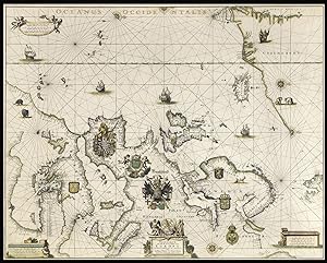
West-Indische Paskaert waer in de graden der breedde over wederzijden van de middellijn wassende so vergrooten dat die geproportioneert sijn tegen hunne nevenstaende graden de lengde. Vertonende behalve[n] Europaes zuydelijcste alle de zeekusten van Africa en America begrepen in 't Octroy bij de H.M.H. Staten Generael der vereenichde Nederl. verleent aende Generale West Indische Compagnie. Mitsgaders die van Peru en Chili inde groote Zuyd-Zee.
Verlag: Amsterdam, Pieter Goos, [ca. 1660]., 1660
Anbieter: Antiquariat INLIBRIS Gilhofer Nfg. GmbH, Vienna, A, Österreich
Verbandsmitglied: ILAB VDA VDAO
Bewertung:
Printed on vellum (ca. 80 x 98 cm) from one large copperplate engraving, partly coloured by a contemporary hand. The "West-Indische Paskaert" engraved by Pieter Goos, in its rare first state, a nautical chart prepared for the Dutch West India Company (WIC) as an aid to crossing the Atlantic Ocean to the trading regions of the Americas and visiting trading posts in Africa. It shows parts of the east coast of North America, both coasts of South America, Mediterranean Europe and the west coast of Africa. Many "West-Indische Paskaerten", as these navigational charts were called, were reprinted over and over from new states of the copperplates. For more than a century Dutch and foreign seafarers profited from their use on transatlantic journeys. The great cartographer Willem Jansz. Blaeu (1571-1638) published the first "West-Indische Paskaert" around 1630 using manuscript charts and other documents of the Atlantic and its coasts, including information provided by the Dutch WIC navigators who sailed these routes. Being one of the first practical uses of the Mercator projection, Blaeu's small-scale nautical chart was the first useful chart for crossing the Atlantic Ocean, making it easier to plot a straight line course for long distances on one map. Around 1660 Pieter Goos engraved four large navigation charts on new copperplates, including the plate for his present "West-Indische Paskaert". The present copy shows the plate in its first state, the only copperplate that Goos actually engraved himself. - Pieter Goos (ca. 1616-75) was a Dutch cartographer, engraver and printer and publisher of maps and atlases, whose father Abraham Goos (ca. 1590-1643) published many globes and maps together with Jodocus Hondius and Johannes Janssonius. He was especially known for his sea charts and his "Zee-atlas ofte water-wereld" (first edition 1666), one of the best maritime atlases of its time. Goos's "West-Indische Paskaert" in its present first state is of the utmost rarity: 8 other copies are known, of which only 4 on vellum. - The "West-Indische Paskaert" remained one of the Dutch West India Company's most important nautical charts for decades, with several important map printers and publishers producing editions from various plates that went through numerous states. The present nautical chart therefore not only bears beautiful witness to the golden age of Dutch maritime history, exploration and cartography; it is also a very rare vellum copy showing the first state of the copperplate engraved by Goos himself. The map has been professionally restored, with the tears along the edges repaired and the brittle parts reinforced with Japanese paper, and the map is mounted on museum-quality preservation corrugated board which in turn is mounted on museum-quality honeycomb board. Somewhat faded, with a water stain in the left part, some smaller stains, the foot a little frayed (hardly affecting the map) and a little dust-soiled, but overall in good condition. - Burden II, 442 (misdated ca. 1674); Schilder & Kok, Goos 4.1 (8 copies, incl. 2 on paper, 1 missing, 1 incomplete); cf Schilder, Monumenta, 63 (other states), 63.4 (the 1675 Blaeu-Goos state); for the use of nautical charts: Koeman, "17e eeuwse Hollandse bijdragen in de kartering van de Amerikaanse kusten", in: Caert thresoor 1 (1982), pp. 50-51; Schilder & Van Egmond, "Maritime cartography in the Low Countries during the Renaissance", in: The history of cartography, volume 3: cartography in the European Renaissance (2007), pp. 1425-1426.
-
West-Indische Paskaert waer in de graden der breedde over wederzijden van de middellijn wassende so vergrooten dat die geproportioneert sijn tegen hunne nevenstaende graden de lengde. Vertonende behalve[n] Europaes zuydelijcste alle de zeekusten van Africa en America begrepen in 't Octroy bij de H.M.H. Staten Generael der vereenichde Nederl. verleent aende Generale West Indische Compagnie. Mitsgaders die van Peru en Chili inde groote Zuyd-Zee.Amsterdam, Pieter Goos, [ca. 1660]. Printed on vellum (ca. 80 x 98 cm) from one large copperplate engraving, partly coloured by a contemporary hand.
Anbieter: Antiquariaat FORUM BV, Houten, Niederlande
Bewertung:
The West-Indische Paskaert engraved by Pieter Goos, in its rare first state, a nautical chart prepared for the Dutch West India Company (WIC) as an aid to crossing the Atlantic Ocean to the trading regions of the Americas and visiting trading posts in Africa. It shows parts of the east coast of North America, both coasts of South America, Mediterranean Europe and the west coast of Africa. Many West-Indische Paskaerten, as these navigational charts were called, were reprinted over and over from new states of the copperplates. For more than a century Dutch and foreign sea farers profited from their use on transatlantic journeys. The great cartographer Willem Jansz. Blaeu (1571-1638) published the first West-Indische Paskaert around 1630 using manuscript charts and other documents of the Atlantic and its coasts, including information provided by the Dutch WIC navigators who sailed these routes. Being one of the first practical uses of the Mercator projection, Blaeu's small-scale nautical chart was the first useful chart for crossing the Atlantic Ocean, making it easier to plot a straight line course for long distances on one map. Around 1660 Pieter Goos engraved four large navigation charts on new copperplates, including the plate for his present West-Indische Paskaert. The present copy shows the plate in its first state, the only copperplate that Goos actually engraved himself.Pieter Goos (ca. 1616-1675) was a Dutch cartographer, engraver and printer and publisher of maps and atlases, whose father Abraham Goos (ca. 1590-1643) published many globes and maps together with Jodocus Hondius and Johannes Janssonius. He was especially known for his sea charts and his Zee-atlas ofte water-wereld (first edition 1666), one of the best maritime atlases of its time. Goos's West-Indische Paskaert in its present first state is of the utmost rarity: 8 other copies are known and only 4 on vellum.The West-Indische Paskaert remained one of the maps for the Dutch West India Company s most important nautical charts for decades, with several important map printers and publishers producing editions from various plates that went through numerous states. The present nautical chart therefore not only bears beautiful witness to the golden age of Dutch maritime history, exploration and cartography; it is also a very rare vellum copy showing the first state of the copperplate engraved by Goos himself.The map has been professionally restored, with the tears along the edges repaired and the brittle parts reinforced with Japanese paper, and the map mounted on museum-quality preservation corrugated board which in turn is mounted on museum-quality honeycomb board. Somewhat faded, with a water stain in the left part, some smaller stains, the foot a little frayed (hardly affecting the map) and a little dust-soiled, but overall in good condition. a very rare state, the first state of the Goos s copperplate nautical chart of the Atlantic in its rare first state and printed on vellum.l Burden II, 442 (misdated ca. 1674); Schilder & Kok, Goos 4.1 (8 copies, incl. 2 on paper, 1 missing, 1 incomplete); cf Schilder, Monumenta, 63 (other states), 63.4 (the 1675 Blaeu-Goos state); for the use of nautical charts: Koeman, "17e eeuwse Hollandse bijdragen in de kartering van de Amerikaanse kusten", in: Caert thresoor 1 (1982), pp. 50-51; Schilder & Van Egmond, "Maritime cartography in the Low Countries during the Renaissance", in: The history of cartography, volume 3: cartography in the European Renaissance (2007), pp. 1425-1426.
-
[Chart of the West Coast of Saudi Arabia and the Red Sea].
Verlag: Amsterdam,, 1701
Anbieter: Daniel Crouch Rare Books Ltd, London, Vereinigtes Königreich
Verbandsmitglied: ABA ILAB PBFA
Bewertung:
Karte
A Dutch East India Company (VOC) manuscript chart fragment of the Arabian Coast and Red Sea signed and dated by Joan Blaeu II Chart fragment in pen, ink, and wash colour on vellum, signed Joan Blaeu II, later profile portrait in charcoal of a lady in early nineteenth century dress to verso, some abrasion to surface of chart. A manuscript chart fragment of the West Coast of Saudi Arabia and the Red Sea, signed and dated by Joan Blaeu II, master chartmaker to the Dutch East India Company, during the Dutch Golden Age. The chart was, at the time, the most accurate depiction of the Arabian and Egyptian coasts of the Red Sea, and is one of only seven extant charts of the area signed by Joan Blaeu II. The chart, drawn on vellum, outlines the coast of the Red Sea from the Gulf of Suez down to the current Saudi Arabian border with Yemen, listing the principal ports and coastal towns, including Jeddah ("Sidade de Judda"). To the sea are marked numerous rocks and shoals, three of which are marked by words in red ink, denoting particular treacherous areas. To the far left is the signature of Joan Blaeu II, the chart's place of production Amsterdam, and the date 1701. Below the signature is a fine compass rose with a fleur-de-lys marking true north, and east marked by a Christian cross, which traditionally denoted the direction of Jerusalem, though, more aptly on this chart, Mecca. A latticework of rhumb lines in red and green ink, typical of sea charts produced in the seventeenth and eighteenth century, and which hark back to the portolans of the sixteenth century, criss-cross the work. The fragment was originally the upper left portion of the: 'Indische Zee gelyckgradighe, van Caep tot de Straet Sunda' [Plane chart of the India Ocean, from the Cape to Sunda Straits], which stretched from the Cape of Good Hope to the Straits of Sunda, the narrow passage of water between the islands of Sumatra and Java. The chart would be carried by all Dutch East India Company ships, on their voyage from Amsterdam to the Dutch port of Batavia, modern day Jakarta. An inspection of the six extant charts with the current example, shows a remarkable consistency in execution, in the placement not only of the geographical information but also in the arrangement of Joan Blaeu II's signature, and the compass rose. One aspect that does change, however, is the omission of the privilege granted by the States General, which appears on his chart of 1688, but is absent on his chart of 1691, our chart of 1701, and a chart dated 1704. Early VOC chart production: In 1602, the Verenigde Oostindische Compagnie (VOC, or Dutch East India Company) was granted a charter by the States General of the Netherlands (the Dutch parliament) to conduct a monopoly in trade east of the Cape of Good Hope and west of the Strait of Magellan. Seventeen years later, in 1619, the Company's monopoly was expanded to include all geographical knowledge (i.e. charts and maps) that had been and would be acquired by the Company. From then on, the dissemination of cartographic information, be it through the publication of charts or rutters, without the express permission of the Company, could lead to a fine of 6000 guilders. This draconian amount suggests not only that the VOC were at pains to keep the latest cartographic knowledge secret, but also that a rather liberal exchange of cartographic knowledge existed before 1619. In order to maintain their hold on the new cartographic information, the Dutch like the Spanish and Portuguese before them, decreed that all charts issued to VOC shipping would be produced by hand (i.e. not printed), and were to be returned to the relevant authorities at the end of each voyage, with substantial penalties for non-compliance. Also, in line with tradition, the charts would be drawn on vellum, a much more robust material than paper, able to withstand the ravages of a long sea voyage. The VOC's first official map and chartmaker was Hessel Gerritsz, who held the position from 1619 until his death in 1632. The position was subsequently filled by three generations of the Blaeu family, the leading cartographic publishers and mapmakers of the seventeenth century, from 1633 until 1705. The Blaeu Family as VOC chartmakers: Although Willem Blaeu had been mooted as chartmaker to the VOC in 1619, his rather liberal Dutch Reformist views were out of favour at the time, and the position was handed to his former assistant Gerritsz. The political and religious climate had eased by 1632, and Blaeu was confirmed as the VOC's map and chartmaker on 3rd January 1633. When Willem passed away in 1638, the position was filled by his son Joan, who, in turn, was succeeded, in 1674, by his son Joan II, who retired from the post in 1705, thus ending the Blaeu families 72 year association with the VOC. The records that survive from Joan Blaeu's time as VOC chartmaker, shine a light on just how profitable the position was for the house of Blaeu. Not only did Joan take a rather liberal approach to the publication of classified information, he was also paid handsomely for the charts he provided to the VOC: for the route from Amsterdam to Batavia a set of nine charts were required, with each chart costing the VOC between five and nine guilders. The captain, chief pilot, and junior pilot each received a full set, with the third watch receiving five. Thus each ship would have a total of at least 32 charts onboard, costing the VOC 228 guilders. It has been estimated that Blaeu made a profit of 164 guilders on each voyage, a margin of more than seventy percent. In 1668, for example, Blaeu submitted an invoice to the VOC for no less than 21,135 guilders! The profits gained by Blaeu's monopoly were obviously crucial in funding his other projects, such as his magnum opus the Atlas Maior, and would go some way to explain why he never produced a printed sea atlas or pilot for the VOC, with any such undertaking undermining his lucrative manuscript chart business. During.
-
[Terrestrial globe]. In ista quam exhibemus Terreni Globi descriptione omnium regionum juxta et insularum .
Verlag: Mattaeus Greuter, 1632
Anbieter: Bruce Marshall Rare Books, Cheltenham, Vereinigtes Königreich
Bewertung:
Karte
No Binding. Zustand: Fine. [Rome], Mattaeus Greuter, 1632. Large engraved terrestrial globe (49 cm diameter) on a brass spindle and ebony-stained wooden base, with 2 sets of 12 half-gores running from 80&730;N to 80&730;S and 2 polar callottes over a plaster-covered papier mâché sphere, unstained wooden horizon and meridian rings, both covered with manuscript paper rings. There are 4 cartouches with arms, figures and navigational instruments (and a depiction of the globe itself); 4 compass roses; two mythological figures and a sea monster; and numerous ships. Partly coloured in outline by a contemporary hand. One of the largest and most accurate terrestrial globes produced before 1650, serving to launch Greuter's short career as Italy's leading globe maker. Though mostly based on Blaeu's largest globe (state 1c of c.1618 or state 2 of 1622), it is more than just a copy. Greuter gives a much more detailed and more accurate depiction of Tierra del Fuego and also reflects the 1624 establishment of a Dutch colony in the present-day New England by labelling it "Nieu Nederland." Not intending his globe as a navigational instrument, he also omitted Blaeu's rhumb lines. Lake Ontario is depicted fairly well, but the other Great Lakes are merged into one enormous body. The Solomon Islands and The Solomon Islands and northern coast of New Guinea, explored by Jacob Le Maire and Willem Schouten in 1616, are depicted (as is "Willem Schouten Eylandt"). Like Blaeu's globe, it indicates the hypothetical coast of the still elusive Antarctica (the ephemeral Dutch sightings of Australia were not to solidify for another decade, but Antarctica shows a northward extension approximately in its place). In the Pacific, a sea god riding on a spouting whale plays a lyre, while a nearby mermaid blows a shell trumpet. The cartouche around the note to the reader (the text used as the "title" in the present description) is flanked by a man with a spade and woman with a whip, together holding an armillary sphere. That around the note on the determination of longitude is flanked by two Ottomans, one with a quadrant and the other with a cross-staff. They both look up at an image of the globe itself, in its four-legged stand. These two cartouches are mirror image copies of Blaeu's, and the texts are based on Blaeu's (the former slightly revised and latter abbreviated in the middle). The scrollwork cartouches around the note on discoveries and around Greuter's new dedication (to Count Jacobo Boncompagni of Aquino) are new, the former with garlands of fruit and the latter topped by the dedicatee's arms. The text of the former is partly based on Blaeu's, but rearranged and with additions and omissions (Greuter's reference to "Cathaić et China" is new; both note Henry Hudson's discoveries). The paper on the horizon ring is drawn and lettered in manuscript, as usual. Although smaller than Blaeu's globe (68 cm), Greuter's is nearly as large as Van Langren's (1589) and Hondius's (1613), and larger than any other globe produced in the Netherlands at the time. Blaeu produced his globe in 1617, but revised it soon after to include Le Maire's new discoveries in Tierra del Fuego and New Guinea. He rendered Tierra del Fuego in three different forms, the last in the globes issued c.1618 and later. While Greuter clearly copied most of Blaeu's globe, he renders Tierra del Fuego more accurately than any of the three Blaeu versions. The closest possible model is Hondius's 1629 map (Koeman & V.d. Krogt II, p. 604, map 9950:2A.1, with a small illustration).
-
Pascaarte van alle de Zee-custen van Europa tot Amsterdam MDCLXXVII, Amsterdam, 1677.
Verlag: Amsterdam,, 1677
Anbieter: Daniel Crouch Rare Books Ltd, London, Vereinigtes Königreich
Verbandsmitglied: ABA ILAB PBFA
Bewertung:
Karte
A majestic sea chart from the Dutch "Golden Age" probably illuminated by the "Meester Afsetter" Dirk Jansz van Santen Separately published large engraved chart, printed in two sheets on thick paper, joined, with fine contemporary hand-colour lavishly heightened in gold. One of the last maps to bear the Blaeu family imprint and a tour-de-force of the mapmaker's art. An exceptional rarity, and a splendid work of art, the Pascaarte of Europe was the work of the grandsons of Willem Jansz. Blaeu, Pieter and Johannes, and one of the last maps to bear the Blaeu imprint as the chart dates from the period following the fire at the Blaeu family's Gravenstraat premises in Amsterdam in February 1672. A year later Johannes Blaeu I died, and the remaining plate stock was auctioned in 1674 and 1677. The present chart of Europe therefore is one of the few productions from the post-fire period. The chart is an improved re-engraving of the elder Blaeu's 1621 (or later) chart with the same title. No census of the 1677 chart has ever been attempted, but Schilder locates only two examples of the c.1621 pascaarte printed on paper, compared to six on vellum. This is the last in a series of large-scale pascaartes of Europe published from c.1606 by the firm of Blaeu. The charts of 1621 and 1677 extend much further west than the earlier examples, so that they include southern Greenland and the Azores. They also add small compass roses that Cannenberg says "show the magnetic variation on the spot." The 1677 chart improves on the 1621 by extending the coast of Greenland, and correcting the coasts of Iceland, Ireland and other parts of Europe. Illumination One of the greatest treasures from the Golden Age of Dutch cartography is the 19-volume 'Atlas van Hadrianus Relandus' at the Meermanno-Westreenianum Museum in The Hague. Not only does it include many legendary maps and sea charts of the seventeenth century, but, according to Herman de la Fontaine Vervey, "the majestic whole has been coloured leaf by leaf by van Santen with the utmost care, using transparent colours, and with even the tiniest details heightened with gold." He was referring to Dirk Jansz van Santen, the "Meester Afsetter" (master colourist), whose "name was renowned throughout his lifetime and long thereafter, and for whose work there was great demand." Dirk Jansz. van Santen "illuminated and gilded the most prestigious printed works of his time in an exceptionally painterly and brilliant manner. In so doing, he made the Golden Age, quite literally, golden" (Goedings). His clients were the foremost collectors of his age, who often described his art in similarly eulogistic terms. Rarely do maps coloured in van Santen's hand come up for sale; rarer still are maps offered that can be ascribed to him with certainty, as he did not sign the works that he illuminated. The present example can confidently be attributed to the master,as it is coloured in a manner identical to that used for the chart of Southeast Asia by Hendrick Doncker in the Hadrianus Relandus atlas. A note in the Relandus atlas reads "artifex eximinus Theodorus van Santen," and when the atlas came up for sale in 1707, the catalog stated that it was "magnificently coloured by Dirk Jansz van Santen, the equal of Blok." This comparison to Joanna Blok-Koerten was a strong accolade, as she was the seventeenth century Dutch artist most celebrated for fine colouring. Examples from the Relandus atlas of two of the three maps here offered are illustrated in Robert Putnam's 'Early Sea Charts'. Both have pale blue oceans, rich colouring in the decorative vignettes, and the lavish use of gold. The colouring is so alike on the two charts that at first we were concerned that they might be the same work, but close inspection revealed such minor differences as the outline color of Japan on ours it is green; on the Relandus copy it is red - that make it clear that they are in fact different charts coloured by the same hand. Truusje Goedings, author of 'Dirk Jansz. Van Santen a Survey', and acknowledged authority on the works of the master colourist, has examined the present charts and compared them carefully with the maps in the Relandus atlas, and has made the following statement: : "I have examined the two charts at Daniel Crouch Rare Books, and the equivalent charts in the 'Atlas van Hadrianus Relandus' at the Meermanno-Westreenianum Museum in The Hague, and I can confidently conclude that these charts were coloured by the same hand". A copy of her full report on the charts is available on request. Burden, P, 'The Mapping of North America', I, #233 (state II/III); Campbell, T, ' Blaeu's second 'West Indische paskaart' of 1630,' in 'The Map Collector', 30, pp. 36-38; Cannenberg, W. V., 'A Dutch Chart that Survived the Ages', in 'Imago Mundi', IV, pp. 62-63; Fontaine Verwey, Herman de la, 'The Glory of the Blaeu Atlas and the Master Colourist', in Quaerendo XI (1981), pp. 197-229; Keuning &c., 'Willem Janzoon Blaeu', plate 10, & pp. 74-75; Putnam, R., 'Early Sea Charts', plates 27, 41; Schilder, G., 'Monumenta Cartographica Neerlandica', IV, pp.100, 45.1 (first edition, dating 1621 or later) and 114-117, plate 2.53; Schilder, G., 'Willem Janszoon Blaeu's Map of Europe (1606), A Recent Discovery in England', in 'Imago Mundi', 28 (1976), pp. 9-20; Waters, D., 'The Art of Navigation', plate LXXVIII; & p. 327; Zandvliet, K., 'Mapping for Money', plate 9.4, & p. 168-169. See also Keuning, 'Hessel Gerritsz', 'Imago Mundi', VI, 49-66; Goedings, T., 'A Composite Atlas Coloured by Dirk Jansz. Van Santen', pp. 24, 25 (no. 3), 32.
-
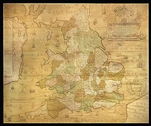
The Travellers Guide being the best Mapp of the Kingdom of England and Principality of Wales Wherein are Delineated 3000 Towns & Villages more than in any Mapp yet Extent besides ye Notations of Bridges & Rivers &c. To which is added ye Direct and cross Roads according to Mr Ogilby's late Survey. Described by C. Saxton And now carefully Corrected with New Additions by Phillip Lea.
Verlag: [1583, but c1716]., London,, 1583
Anbieter: Daniel Crouch Rare Books Ltd, London, Vereinigtes Königreich
Verbandsmitglied: ABA ILAB PBFA
Bewertung:
Karte
A nation defined An Elizabethan wall map by "the father of English cartography" Engraved wall map, printed on 20 sheets, joined, with fine original full body colour. Christopher Saxton's wall map is a result of the first survey of the whole of England and Wales, and is the first map of those countries to give all the place names in English. Saxton has been dubbed "the father of English cartography" (Skelton). The idea of making a survey of the kingdom and its parts in a consistent format developed in the mid sixteenth century. Although the first English map of Britain, by Matthew Paris, had appeared in about 1250, it was not until the mid fifteenth century that the principles of mapping were fully understood. These techniques emerged, in part, as a result of the practical needs of military engineers: military surveyors were well able to draft plans and topographical maps to scale by the 1540s. Estate surveys also became increasingly popular, as the advent of enclosures necessitated the definition of land boundaries. Thus, a large number of treatises on surveying and the use of the cross-staff appeared. Such interest led to the construction of increasingly sophisticated surveying instruments, resulting in a new accuracy in mapping. Saxton's wall map dates from 1583, and was published separately from his atlas of 1579. Only two copies of the first state of the map are known to exist: one in Birmingham Public Library, printed on paper with watermarks consistent with the date on the map; the second example is bound in atlas form in the British Library and is probably a reprint from the original plates by William Web, dating from c.1642. "After the Restoration, Saxton's map was reissued on several occasions by publishers who made considerable alterations to the plates" (Shirley). Of these, only the second state, published by Cade and Morgan in 1678, is known to have been issued as a 20-sheet wall map. The others were printed in a travelling "portmanteau" format by Philip Lea. However, "the excellence of the engraving and the rich style of the Elizabethan decoration can only be appreciated fully when the map is seen as a single work" (Shirley). The present example, however, was issued once again in the intended wall map format. It bears the imprint of Philip Lea, but with the "Fleet Street" address of his widow, Anne. It is, therefore, according to Skelton, the seventh state of the map and dates from 1716-1720. The map does not include the name of an engraver, but it is generally accepted that it is Augustine Ryther, who engraved Saxton's earlier map of England published in his county atlas. Ryther was the most accomplished of a team of seven English and Flemish engravers who worked on the county maps in the atlas. Comparison with the county maps shows that Saxon has modernised the spelling of several of the place names and redrawn the Isle of Wight. Bodies of water, vegetation, settlements and notable buildings are all identified. Hills and mountains are also pictorially defined; the "aim was to convey an impression of topography rather than to provide precise information on the location and altitude of individual summits" (Evans and Laurence). Saxton has used the old English mile of ten furlongs, as the eight furlong mile was not instituted until 1593. Saxton's depiction was adopted subsequently by Mercator, Speed, Blaeu, and Jansson, and was recognised internationally as the standard representation of England and Wales until the second half of the eighteenth century. Examples of Saxton's map, in any form, rarely come to market. We are only aware of one example selling at auction in the past 50 years: a later version by Thomas Bowles from around 1720 at Sotheby's New York on 12 November 1968, lot 28A. Ifor M. Evans and Heather Lawrence, Christopher Saxton, Elizabethan map maker (London: Holland Press, 1979), 9-43; Shirley, British Isles, 137.
-
Atlas maior. Amsterdam, Johannes Covens & Cornelis Mortier, [ca. 1725]. Imperial folio (53 x 35.5 cm). With engraved title-page and 76 double page (or in 8 cases larger folding) engraved maps, the title-page and all maps and their decorations coloured by a contemporary hand. Half tanned sheepskin (ca. 1900), gold-tooled spine.
Anbieter: ASHER Rare Books, T Goy Houten, Niederlande
Bewertung:
Extremely rare Covens & Mortier edition of De Wit's Atlas maior, here with the engraved allegorical title-page and all 76 maps and their decorations beautifully coloured by a contemporary hand. It combines maps originally issued by Frederick de Wit, with ones from Nicolaes Visscher II and others. De Wit and Visscher were the leading map and atlas publishers in the Netherlands after a fire crippled the Blaeu firm in 1672. De Wit is known especially for the beautiful pictorial decorations on his maps. Only one other copy is recorded in the literature, at the Depôt de Marine in Paris.The atlas opens with Carel Allard's ca. 1696 world map in 2 hemispheres. Among the other maps are 6 of the continents; Nicholas Sanson's map of the poles; 2 maps nominally of the Ottoman Empire but including besides the entire Arabian peninsula, also most of Iran and either the entire Mediterranean Sea (Visscher) or its eastern part (Jaillot); Homann's map of Iran; De l'Isle's map of India, Southeast Asia and the East Indies (folding); Visscher's map of the West Indies; De Wit's maps of Malta and of Corsica & Sardinia. Within Europe the atlas gives special emphasis to the Low Countries, with 19 maps.With a long tear along the fold repaired in 2 double-page maps and small tears where two folds cross in 1 larger folding map, but otherwise in very good condition and with large margins, with only an occasional small tear at the head or foot of the fold, one or two maps with an unintended fold and one with a small hole. Two maps are slightly smaller than the others and have therefore had some of their margins extended. A splendid hand-coloured great atlas, with only one other copy recorded.l Koeman, C & M 2 (1 copy, with 100 maps), cf. C & M 1 (based on 18th-century catalogues); V. Egmond, Covens & Mortier (2005), III.2 (pp. 143-145, citing Covens & Mortier's ca. 1721 catalogue).
-
Portraitphotographie mit eigenh. Widmung und U.
Verlag: Wien, 1917, 1917
Anbieter: Kotte Autographs GmbH, Roßhaupten, Deutschland
Bewertung:
Manuskript / Papierantiquität
130 : 198 mm auf Trägerkarton (283 : 178 mm). Das Brustbild im Profil zeigt laut Kulturpool, Österreichs Portal zu Kunst, Kultur und Bildung" Gustav Klimt im Alter von 55 Jahren vor seinem Atelier in der Feldmühlgasse 11 in Wien. Es sei eines der letzten Aufnahmen des Künstlers. Aufgenommen wurde sie von Moritz Nähr (1859 - 1945). Mit Widmung Wien 1917 | Frau Johanna Staude zur freundlichen Erinnerung von Gustav Klimt".Gustav Klimt hat die charismatische Persönlichkeit von Johanna Staude (1883-1967) in den Jahren 1917/17 im berühmten Gemälde Johanna Staude" festgehalten. Das Brustbild blieb unvollendet. Johanna Staude stand nicht nur Klimt sondern auch Egon Schiele Modell. Klimt hat Johanna Staude wohl auch Arbeit beim Schriftsteller Peter Altenberg verschafft, der sie als modernen Engel" beschrieb. Klimts Farbpalette hatte sich mit dem Tod seiner Mutter 1915 verdüstert. In Johanna Staudes Bildnis setzt Klimt auf das beherrschende blaue Kleid und den orangeroten Hintergrund. Auch wenn Johanna Staudes Mund unvollendet ist, wird der Betrachter doch von ihrem Gesicht angezogen.Der Fotograf Moritz Nähr war es auch, der im Mai 1911 das weltberühmte Foto von Gustav Klimt mit Katze auf dem Arm aufgenommen hatte. Nähr war ein umtriebiger und origineller Fotograf im Wien des Fin de Sičcle. Mit Klimt verband ihn eine jahrelange Freundschaft mit täglichem gemeinsamem Frühstück. Das Atelier war der Ort an dem Gustav Klimt von 1911 bis zu seinem Tod 1918 einige seiner wichtigsten Werke schuf. Er arbeitete hier an mehr als 50 Gemälden, darunter weltbekannte Bilder wie Adele Bloch-Bauer II", Friederike Beer", Die Braut" und Adam und Eva". Am 6. Februar 1918 starb Gustav Klimt im Alter von nur 55 Jahren an den Folgen eines Gehirnschlags.Zu Beginn seiner Karriere widmete sich Gustav Klimt dem Historismus", einer Stilrichtung, die er lange an der Kunsthochschule studiert hatte. Ein Beispiel hierfür sind seine Wand- und Deckenmalereien und Portrait-Arbeiten. Trotz dieser Erfolge brach er mit dieser Tradition und wandte sich dem Jugendstil zu und gründet deren Hochburg" - die Wiener Secession. Durch die Auseinandersetzung mit dem Jugendstil fand er seinen eigenen persönlichen Ausdruck und gilt heute als der bedeutendste Maler seiner Stilepoche.Typisch für den Jugendstil, ließ sich Klimt von der Natur inspirieren. Seine Werke sind geprägt von floralen Motiven und Ornamenten. Seine zweidimensionale Flächenkunst wird durch die fließenden Linien, Ornamente und geometrisch-spiralförmigen Formen charakteristisch. Durch diese Art der Linienführung entsteht in seinen Bildern ein Eindruck von Lebendigkeit. Traum und Symbolbilder kommen in seinen Bildern zum Ausdruck. Durch die Verwendung von Symbolen hatte Klimt die Möglichkeit, die alte Tradition in die neue Kunstrichtung zu integrieren.Klimt setzte sich mit existenziellen Fragen auseinander. Der zentrale Punkt in seiner Kunst war um Freude zum Leben. Dabei gab er dem Leben einen erotischen Ausdruck. Klimts Hauptaugenmerk lag auf Figuren- und Landschaftsbildern. Am liebsten malt er Menschen, und ganz besonders Frauen. In vielen seiner Bilder stehen erotisch dargestellte und nackte Frauen im Mittelpunkt wohl im Streben danach, den Mythos der Frau zu ergründen.Moritz Nähr war nicht nur mit den Secessionisten vernetzt", sondern auch mit dem Kaiserhaus und der Familie Wittgenstein. Er fertigte klassisch gewordene Porträts des Philosophen Ludwig Wittgenstein an, wie auch von Gustav Mahler, den er 1907 in der Loggia der Wiener Hofoper fotografierte. Der Fotograf experimentierte mit dem Medium. So machte er sich etwa darüber Gedanken, welche neuen Facetten ein Bild durch die Wahl eines bestimmten Ausschnitts erhält. Auf besonderen Anklang stieß Nährs Sinn für die künstlerische Inszenierung bei den Secessionisten, die ihm die Anfertigung effektvoller Ausstellungsansichten übertrugen.
-
Autograph manuscript with 12 watercolours, one of which is a title border and a pen and ink drawing.
Verlag: [No place, but Montagnola, ca. 1957)., 1957
Anbieter: Kotte Autographs GmbH, Roßhaupten, Deutschland
Bewertung:
Manuskript / Papierantiquität
8vo (254x168 mm). 26 ff. Limp vellum binding with title calligraphed in red ink on the front cover. In clamshell box of red morocco, signed by Hugo Peller. Front cover with blindruled intersecting fillets and gilt dots on the left side and gilt lettering "Handschrift von Hermann Hesse" on the right side. Rear cover lined with parchmentpaper, lined with brown calfskin on the inside. As early as 1918, Hermann Hesse began illustrating his own poems with small watercolours and selling twelve of them at a time, with an additional cover sheet, for 200 (typewritten) or 250 Swiss francs (for handwritten copies).The proceeds went to the prisoners of war of the First World War, for whom Hesse organised book shipments from Bern. Later, he offered the Twelve Poems to patrons and collectors to help those persecuted by National Socialism during the Second World War or to support penniless artist friends. Hesse continued to create these collections of poems into old age, not just for sale, but also as gifts for friends.This manuscript contains the following poems written between 1904 and 1933: Morgen, Liebeslied, Blauer Schmetterling, Frühlingstag, Voll Blüten, Alterwerden, Vergänglichkeit, Rückgedenken, Abendgespräch, Traum von der Mutter; Bruder Tod, and Einsame Nacht (erroneously for Einsamer Abend).The accompanying watercolours depict mainly Ticino landscapes. The poem Liebeslied shows a flower vase, Traum von der Mutter a pen and ink drawing of a house and Einsame Nacht an interior with a lit candlestick on a table.A beautifull copy in a custom made morocco clam-shell box by the Swiss bookbinder Hugo Peller (1917-2003).
-
Gerardi Mercatoris - Atlas sive Cosmographicae Meditationes de Fabrica mundi et fabricate figura De novo multis in locis emendates et Appendice auctus Studio Judicu Hondii.
Verlag: Sumptibus Johannis Cloppenbergii, Anno 1630., Amsterdam,, 1630
Anbieter: Daniel Crouch Rare Books Ltd, London, Vereinigtes Königreich
Verbandsmitglied: ABA ILAB PBFA
Bewertung:
Buch
From the inventory of the Van Keulen family of cartographers 2 works in one volume. Oblong 4to., (250 by 275mm). 2 letterpress sectional title-pages, additional allegorical title-page with magnificent contemporary hand-colour in full, heightened with gold, a total of 180 engraved maps with contemporary hand-colour in outline, contemporary blind-paneled vellum over paste-board, title in manuscript on the spine. Collation: [-](4), A-I(4), K-T(4); V(4), X-Z(4), 2A-I(4), 2K-T(4), 2V(4), 2X-Z(4), 3A-I(4), 3K-T(4), 3V(4), 3X-Z(4), 4A-I(4), 4K(4)-Q(4); [4] pages, [1]-676; 'Appendix' a-f(4);[1-3], 4-[48] First edition of Cloppenburg's version of the miniature Mercator-Hondius atlas, with the 'Appendix', containing twenty-two maps. A finely coloured example, and rare as such, from the inventory of the Van Keulen family of cartographers. Including, as the last map in the 'Appendix', 'Nova Virginiae Tabula ': the first reduced version of "the first and most important derivative of John Smith's map of Virginia" (Burden 193), first published in 1612. Smith's map had been reprinted by Jodocus Hondius between 1618 and 1629, and then when he died Blaeu purchased the plate and used the map in his'Atlantic Appendix', 1630, and afterwards in virtually every edition of his atlas. By 1630, there were a reduced number of choices for consumers wanting to buy a small format atlas: the Ortelius 'Epitome' was published only through the first decade of the seventeenth century, although there were Italian imitations; Bertius' 'Tabularum' was last published at the end of the second decade; and the Mercator-Hondius 'Atlas Minor', the copperplates of which had been sold outside the family and shipped to England where they were used by Samuel Purchas, were replaced by the Janssonius issue of 1628, with new and enlarged maps. As with Janssonius' issue, the plates for Coppenburg's edition were engraved by Petrus Kaerius, or Pieter van den Keere. They were slightly larger than these, but also modelled on the folio sized map from the original Mercator-Hondius atlas of 1606. Cloppenburg's atlas was short-lived, he managed to publish further editions of in Latin in 1632, and another in French in 1636, after which it is possible that it was in fact suppressed. Or, perhaps he just went out of business. The van Keulen family operated a chart-making and publishing firm in Amsterdam for nearly 200 years. It was founded by Johannes van Keulen(1676-1718)who registered his business as a "bookseller and cross-staff maker", and in 1680 obtained a privilege from the States General of Holland and West Friesland allowing him to print and publish maritime atlases and shipping guides. This privilege, which protected against the illegal copying of printed material, was especially important for the cartographer's atlases, which were produced with extensive initial costs. Van Keulen named his firm 'In de Gekroonde Lootsman' (In the Crowned Pilot), and began collaborating with cartographers Claes Janz Vooght and Johannes van Luyken. The firm would go on to become one of the most successful publishing firms in Amsterdam; and produce "the largest and finest marine atlases in Holland" (Koeman). Van Keulen's first atlas was his 'Zee Atlas' with about 40 charts. "The culmination in the development of Dutch pilot books was reached with the publication of 'De Nieuwe Groote Lichtende Zee-Fackel ' in 1681.The work was immediately recognized as superior to anything else on the market and enjoyed a considerable reputation for accuracy and detail' (Martin & Martin, 11). On the death of Joannes in 1704 the firm passed to his son, then his grandson, and on the death of Cornelis Buys van Keulen the name of the firm "was altered after much palaver into Gerard Hulsst van Keulen. The surviving son conducted the publishing business with more ambition than before. A considerable number of books appeared in the period 1778-1801. Greater activity was developed in the cartographic branch and new issues of the "Zee-Fakkel" again saw the light" (Koeman page IV 279). The Weduwe (ie Anna Hendrina Calkoen,Widow of)Gerard Hulstvan Keulen, was head of thefirm between 1801 and 1810, and the company continued to publish under her imprint until 1885, although by then the firm was being operated by the descendants of employeeJacob Swart Boonen. One of these was Gerrit Dirk Bom, who published a history and bibliography of the firm, 'Bijdragen tot eene geschiedenis van het geslacht - Van Keulen - als Boekhandelaars, Uitgevers, Kaart - en Instrumentmakers in Nederland; eene Biblio-cartographische Studiein', Amsterdam: H.G. Bom, 1885, in the hopes of finding a buyer for the company. However, the possessions of the firm were sold at auction in 1885, bringing 200 years of "DeGekroonde Lootsman" to an end. Much of what was offered was purchased by theAmsterdam antiquarian book and map-seller FredrikMuller & Co., who (according to the Library of Congress), sold the items individually at public sales in 1887. Rare: no examples of this atlas with contemporary hand-colour have appeared at auction in current records; uncoloured examples of this edition are found at: Yale University Library; Indiana University; State Library of Victoria; Bibliothčque Nationale de France; Zeeuwse Bibliotheek Middelburg; University of Amsterdam; Bibliothčque cantonale et universitaire - Université de Fribourg; and the Universidad de Salamanca. Provenance: 1. Contemporary ownership inscription of 'B.o D Zirbor' (ie Biblioteque D Zirbor), on the first section title-page 2. Inscribed by Frederik Muller upper right-hand corner of the front free endpaper: "971 V.K. from van Keulen's Library Amsterdam" Koeman, C. Atlantes Neerlandici, cop. 1967-1971, V. II, cat. Me 29 A -cat Me 29B (p.339-343); see Tiele, P.A. 'Nederlandsche bibliographie van land- en volkenkunde'. 1884. p. 168.
-
Illustriorum Italiae urbium tabulae, cum appendice celebriorum in Maris Mediterranei insulibus civitatum
Verlag: Amsterdam, Janssonius, 1657,, Amsterdam, 1657
Anbieter: Libreria Antiquaria Pregliasco, Torino, Italien
Bewertung:
Zustand: molto buono. in-folio massimo (490x320 mm), ff. (2 frontespizio e dedica), 149. Legatura Blauiana in piena pergamena, fregi oro ai piatti e al dorso, fleuron centrale in oro riquadrato, dorso a 6 nervi decorato in oro, con unghie, tagli dorati (numerose macchie ai piatti). Raro volume che raccoglie 79 vedute di cittŕ italiane, scenografiche e a volo d'uccello, di cui 3 grandi tavole ripiegate piů volte (Roma antica, Venezia e Firenze), 57 su doppia pagina e 19 a mezza pagina, tutte incise in rame. Il grande atlante delle cittŕ di J. Janssonius fu pubblicato nel 1657. Si compone di otto volumi, che raffigurano importanti cittŕ di tutto il mondo. La maggior parte di queste piante e vedute sono stampate da lastre di rame utilizzate da Braun e Hogenberg per il loro famoso "Civitates orbis terrarum". Altre vedute sono imitazioni di Blaeu. Edizione in tiratura originale di questa stupenda opera, completa di tutte le tavole e del testo latino. Esemplare marginoso e genuino, ma uniformemente brunito. Cremonini n.34. Book.
-
Emblemata amatoria. Afbeeldinghen van minne. Emblemes d'amour.Amsterdam, Wilem Jansz. Blaeu, 1611. Oblong 4to (15 x 19 cm). With an engraved title-page, with the title in Latin, Dutch and French. With 30 engraved emblems (ca. 10.5 x 13.5 cm), each with tri-lingual mottos in the engraving and distichs in Dutch with Latin and French translations on the opposite page. The Dutch text is mainly set in gothic letters, while the Latin and French texts are set in roman and italic letters respectively. The Dutch songs and sonnets in the second half of the work are set in roman and gothic letters, sometimes in two columns. 19th-century gold-tooled red sheepskin, with two triple-fillet frames and 4 ornamental corner pieces between the two frames. With an elaborately gold-tooled spine, including the French title and the year of publication, gold-tooled board edges and turn-ins, gilt edges, marbled endpapers and a yellow, red and green reading ribbon.
Anbieter: Antiquariaat FORUM BV, Houten, Niederlande
Bewertung:
Erstausgabe
144 pp.First edition of a landmark in the history of Dutch literature and the apogee of Dutch emblem books, written by one of the most important authors of the Dutch Golden Age, Pieter Cornelisz. Hooft (1581-1648). This edition was the first publication in an impressive series of books presenting contemporary Dutch poetry and literature, printed and published by Hooft's cousin, the great Amsterdam cartographer, printer and publisher Willem Jansz. Blaeu. The emblems are followed by 48 songs, poems and sonnets, 45 published here for the first time. A second and expanded edition followed in 1618.The Latin and French translations of the distichs were done by Cornelis G. Plemp and Richard Jean de Nérée. The beautiful, very detailed engravings have been variously attributed to Michel and Christoffel le Blon, Jan Pinas, Simon Frisius and Pieter Serwouter.The binding is very slightly scuffed around the corners and the head and foot of the spine, the first and last few pages are slightly browned, occasional very slight foxing. Otherwise in very good condition.l Hollstein (Dutch & Flemish) XXVI, p. 250, no. 59; Landwehr, Emblem Books Low Countries 320; Leendertz 17; Praz, pp. 124-125, 371-372; STCN (5 copies); De Vries, Emblemata 48.
-
Erneuert- und Vermehrtes Wappenbuch, in welcher aller hohen Potentaten der Römischen Kaysere, Könige, des Heil. Römischen Reichs Chur-fürsten. Wappen, Schilde, Helmen, Kleinodien. in schönen Kupfern vorgebildet. Auf das Neue verfertiget und zum Druck befördert.
Verlag: Nürnberg, Fürsts Witwe und Erben sowie J.R. Helmers, 1696-1704., 1704
Anbieter: Antiquariat F. Neidhardt, Böblingen, Deutschland
Bewertung:
6 Teile in einem Band. Folio. Tle. 1-6, 5 und 6 jeweils mit Anhang, sowie Register. 78 Titel, Zwischentitel, Text und zwei Generalregister am Ende. Mit gestoch. Frontispiz, 1 Textkupfer und 12458 (!) kolorierten Wappendarstellungen von 1201 Kupfern auf 623 Tafeln. Blindgeprägter Schweinslederbd. der Zeit mit Mesingschließen und dunkelblau gefärbtem Schnitt. Das berühmte, umfangreiche und prachtvolle Wappenbuch vollständig in feinem Altkolorit, so von größter Seltenheit. Der immense Umfang und die sehr sorgfältige Ausführung des Kolorits in Blau, Rot, Schwarz, Gelb, Grün und vereinzelt Purpur ist äußerst spektakulär.- Es liegt eine Mischausgabe der letzten bei Fürst erschienen Ausgabe und der Helmer'schen Ausgabe vor, die erstmals 1699 erschien und 1704 durch das Generalregister der sechs Teile erweitert wurde. Es handelt sich um die insgesamt 7, 8. und 9. Ausgabe des prachtvollen Werks. Nur die ersten beiden Teile stammen von Siebmacher, nach seinem Tode (1611) gingen die Platten an Paulus Fürst über, der sie wiederholt zu neuen Ausgaben benutzte und das Werk um vier Teile erweiterte.- "In seiner Vorrede hat Siebmacher schon bedacht, daß die Schilde ausgemalt werden. aber wer macht sich solche Mühe ? Versucht hat es mancher, wie wenige nur am Anfang kolorierte Exemplare zeigen. Vollständig kolorierte. gehören zu den großen Seltenheiten (und sind nur in zwei Exemplaren bekannt)" Horst Appuhn im Nachwort zu einer Reprint-Ausgabe, Dortmund, 1994.- Komplettes Exemplar von sehr guter Gesamterhaltung. Leicht gebräunt, Kolorit verso teils etwas durchschlagend, einige sehr wenige und nur kleine Randeinrisse. Kupfer 1 und 169 in Teil I mit kleiner Fehlstelle im Rand, die Kupfer 91 in Teil III, Kupfer 200 in Teil IV und die letzten 4 Blätter mit kleinen, alten Hinterlegungen im Rand, ein Wappen auf Kupfer 278 in Teil V sorgfältig ausgeschnitten und die Fehlstelle alt hinterlegt. Gelenke restauriert, Vorsätze und Schließen erneuert.- Der Zwischentitel vor Teil I mit montierter zeitgenössischer, kurzer Beschreibung des vorliegenden Exemplars in deutscher Sprache und dem zusammenfassenden Hinweis: "exemplar vix in germania reperibile".- Exlibris "Bibliotheca Lindesiana", "J.C.J, de Kohausen de Büschendorf" und "F.C. Koch, Rotterdam".- Henning-Jochums S. 282.- Vgl. Lipperheide Rc10. Sprache: deutsch.
-
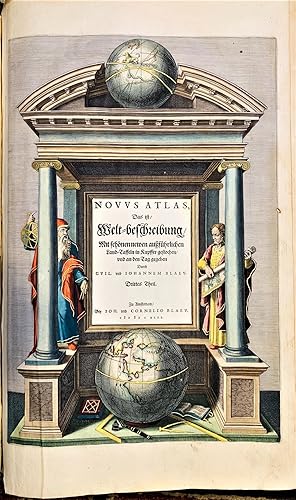
[A set of the world and four continents]. Nova Totius Terrarum Orbis Geographica ac Hydrographica; Europa recens descripta; Africae nova descriptio; Asia noviter delineata; Americae nova Tabula.
Verlag: [1644-55]., Amsterdam,, 1644
Anbieter: Daniel Crouch Rare Books Ltd, London, Vereinigtes Königreich
Verbandsmitglied: ABA ILAB PBFA
Bewertung:
Karte
A fine set of Blaeu's maps of the world and continents Five engraved maps with fine original hand colour, heightened with gold, French and Latin text to verso. A fine set of Blaeu's maps of the world and the four known continents. The Blaeu family popularised the carte-a-figure style of cartography, surrounding their maps with borders showing the native inhabitants of the country and city views. The four continents are shown in this style, with a border of views of major cities at the top and couples wearing the costume of their region at the sides. The border of the world map contains personifications of the four elements and four seasons at the sides, views of the seven wonders of the ancient world at the bottom, and the planets personified as classical deities at the top. In the world map, one of the earliest to use the Mercator projection, Blaeu has chosen not to show California as an island, as it often is on contemporary publications. He does, however, show North America separated from Asia by the mythical Strait of Anian. Much of North America remains blank and unexplored, with a cartouche placed strategically in the middle. There are two polar maps in the lower corners: the North Pole is left blank, showing the recent Dutch discovery of Novaya Zembla; the South Pole shows the mythical southern continent, Magellanica, thought to have been discovered by Magellan as he passed through the strait named after him.
-
![Bild des Verkäufers für Atlas Novus, Sive Theatrum Orbis Terrarum: In quo Hispaniae, Italiae, Asiae, Africae, nec-non Americae. Tabulae & Descriptiones luculentissimae. Tomus tertius [dividido en dos partes, cuyas portadas ambas son dos frontis bellamente grabados] zum Verkauf von Librería Miguel Miranda](https://pictures.abebooks.com/inventory/md/md1368321724.jpg)
Atlas Novus, Sive Theatrum Orbis Terrarum: In quo Hispaniae, Italiae, Asiae, Africae, nec-non Americae. Tabulae & Descriptiones luculentissimae. Tomus tertius [dividido en dos partes, cuyas portadas ambas son dos frontis bellamente grabados]
Verlag: Apud Ioannem Ianssonium, 1649
Anbieter: Librería Miguel Miranda, Lope de Vega n.ş XIX, Madrid, M, Spanien
Bewertung:
Karte
Zustand: Good / Bien. Amstelodami: Apud Ioannem Ianssonium, Anno 1649.- TOMO III, en un volumen de 358 folios, dividido en 2 partes, ambas con sendos frontis grabados al cobre, incluyendo 100 maravillosos mapas a doble folio con los países y continentes citados en la portada, magistralmente grabados al cobre y muy bien conservados; In-Folio Imperial (50 x 35 cm.); Texto en latín; Encuadernado en Plena Piel Pergamino Epoca con dobles ruedas paralelas doradas en planos o tapas, la exterior filete en oro y la interior tipo cadeneta dorada con florones en los ángulos de la rueda interior, y en el centro de ambas gran hierro dorado ornamental barroco floreado. Lomo liso con ruedas paralelas de cadeneta dorada, a modo de nervios, así como florones entre cada rueda.- CONTIENE LOS SIGUIENTES MAPAS, en excelente estado de conservación: HISPANIA: 1. Biscaia y Guipuscoa; 2. León; 3. Galicia; 4. Portugal; 5. Andalucía (Sevilla y Córdoba); 6 Andalucía (Granada y Murcia); 7 Valencia; 8. Aragón; 9. Cataluńa; 10. Baleares insulas. ITALIA: 11. Italia general; 12. Venecia; 13. Bergamo; 14. Brescia; 15. Cremasco; 16 Verona; 17. Polesino di Rovigo; 18. Bizentium; 19 Padova; 20. Trevińano; 21. Belunese; 22. Friuli; 23. Istria; 24. Stato di Milano; 25. Milano pars alpina; 26. Ducato di Milano; 27. Pavia, Lodi; 28. Cremona; 29. Pedemonti; 30. Monferrato e Piemonte; 31. Bercelii; 32. Mantova; 33. Liguria; 34. Genova ponente; 35. Riviera di Genova, levante; 36. Corsica insulae; 37. Sardegna insulae; 38. Lucca; 39. Fiorentino (Dominio) Etruria; 40. Siena con il Ducato di Castro; 41. Parma et Piacenza; 42. Ischia, olim Aenoria; 43. Elba insulae; 44. Ducato di Modena; 45. Vaticano-Dominium Eclesiasticum; 46. Ducato di Ferrara; 47. Romagna e Flaminia; 48. Bologna; 49. Orvieto; 50. Perugino; 51. Urbino; 52. Campagna di Roma et Sabine; 53. Umbría; 54. Dancona, Marchia Anconitana; 55. Nápoles; 56. Abruzzo, citra y ultra; 57. Lavoro; 58. Molise; 59. Citra olim Picentia; 60. Capitanata olim Mesapiae; 61. Bari et Basilicata; 62. Otranto; 63. Calabria citra; 64. Calabria ultra; 65. Sicilia insulae; 66. Candia olim Creta insulae. ASIA: 67. Asia general; 68. Turcicum Imperium; 69. Turquía Natolia; 70. Chipre insulae; 71. Persia; 72. Tartaria sive Magnichami; 73 China; 74. Japón insulae; 75. India oriental; 76. Mongolis Imperium; 77. India oriental insulae; 78. Molucas insulas. AFRICA: 79. Africa general; 80. Barbarie, Tunetonum, Aegiptus; 81. Fez y Marruecos; 82. Guinea; 83. Etiopia Superior Abissiniorum; 84. Etiopía Inferior. AMERICA: 85. América general; 86. Nueva Bélgica y Nueva Inglaterra; 87. Virginia; 88. Virginia y Florida oriental; 89. Bermudas insulas; 90. Nova Hispania et Nova Galicia; 91. Caribe, Insulae Espańola et Cuba; 92. Sud Americae Meridionalis; 93. Nueva Granada et Pompayan; 94. Perú; 95. Venezuela y Nueva Andalucía; 96. Guyana, Amazonam Regio; 97. Brasiliae; 98. Paraguay; 99. Chile; 100. Patagonia, Estrecho de Magallanes. ESTE ATLAS CONSTABA DE 4 TOMOS, PERO ESTE TOMO III QUE OFRECEMOS CONTIENE LOS CODICIADOS MAPAS DE AFRICA, ASIA Y AMERICA, JUNTO CON LOS DE ESPAŃA E ITALIA. MUY RARO. TODOS LOS MAPAS SE ENCUENTRAN EN EXCELENTE ESTADO. La encuadernación, aunque completa, está algo fatigada y con seńales del tiempo, estando el lomo con los dorados poco marcados. Es de lamentar que alguien haya arrancado, y por tanto FALTAN, los tres siguientes mapas: Mapa General de Hispania, Mapa de Navarra Regnum, y Mapa de Castilia Vetus & Nova. Jan Janssonius fue un gran cartógrafo alemán del siglo XVII, siendo además librero y editor, de cuyas prensas salieron maravillosos mapas grabados que rivalizaron en maestría con los de su coetáneo Wilhelm Blaeu y nos ofrecen una impresionante visión geográfica del mundo que se conocía. Libro en latín GEOGRAFÍA, GUÍAS Y ATLAS DEL EXTRANJERO.
-
Novus Atlas.
Verlag: Das ist Welt-bescreibung mit schonen newen auszfuhrlichen. Land-Taffeln in Kupffer gestochen und an den Tag gegeben Durch. Guil. und Iohannem Blaeu. Drittes Theil. Zu Amsterdam Bey ioh. und Cornelio Blaeu, 1642 , Amsterdam, 1642
Anbieter: Libreria Antiquaria Pregliasco, Torino, Italien
Bewertung:
Zustand: molto buono. in-folio (mm 495x325), bellissima legatura coeva in pieno marocchino testa di moro, grande fleuron al centro dei piatti e decorazioni fitoformi agli angoli, il tutto racchiurso entro larghe cornici dorate, filetti e fregi oro al dorso a sette nervi, tagli dorati e cesellati. La pressione dei ferri dorati č stata particolarmente profonda sulla pelle spessa e morbida, rende la rilegatura veramente degna di nota.Il terzo volume dell'Atlas Novus, dedicato all'Italia, completo del frontespizio architettonico: il portico con colonne in stile ionico, con i due grandi globi, celeste e terrestre. Nella parte sinistra č raffigurato Tolomeo con in mano la sfera ed il compasso, a sinistra Magini con una carta geografica. Esemplare completo delle 66 tavole incise in rame a doppia pagina arricchite da bellissima colorazione coeva e rialzi in oro. Ogni carta geografica č arricchita da cartiglio con titolo ed alcune specificitŕ relative alla zona rappresentata. Le ultime 8 tavole riguardano la Grecia ed il Regno Unito. In fine, un'Appendice con l'elenco delle tavole contenute nel volume, bellissimo esemplare fresco, marginoso, qualche traccia di offset dovuta alla colorazione strettamente coeva. Raro a trovarsi completo delle tavole ed in queste condizioni di conservazione. Il Theatrum Orbis Terrarum sive Atlas Novus rappresenta la prima grande produzione cartografica di Willelm Janszoon Blaeu (1571-1638), a soli 5 anni dalla pubblicazione del suo primo atlante, l'Atlantis Appendix del 1630. La prima edizione del 1635, in soli due volumi, č edita in tedesco, olandese, francese e latino. Il terzo volume, quello riguardante l'Italia, č pubblicato per la prima volta nel 1640, con testo in francese e latino; tre ulteriori volumi vengono successivamente aggiunti sino alla definitiva edizione in sei volumi del 1655. Le carte dell'Italia contenute in quest'edizione rappresentano la prima edizione latina delle carte della penisola del Blaeu, basate sulle lastre di Jodocus Hondius giŕ incluse nell'Appendix, derivanti dal modello di Giovanni Antonio Magini (1620). Koeman, I, Bl41A. Book.
-
Speculum naturale.
Verlag: [Straßburg, Drucker mit dem bizarren R (Adolf Rusch), nicht nach 1476]., 1476
Anbieter: Matthaeus Truppe Antiquariat, Graz, Österreich
Bewertung:
Buch Erstausgabe
Bd. 1 (von 2). Gotico-Antiqua. 367 (statt 370, ohne 2 weiße und das erste Textblatt) nn. Bll. mit 2 Spalten zu je 66 Zeilen durchgehend rubriziert, mit eingemalten Lombarden in Rot und Blau und 6 teils. historisierten Pracht-Initialen (diese von neuer Hand). Erste Ausgabe der umfassendsten und größten Naturenzyklopädie des Mittelalters, verfaßt von dem Dominikaner Vinzenz von Beauvais, sehr selten. - GW M50635. Goff V 292. BSB-Ink. V-206. Amelung, Reutlingen 97. Klebs 1036.1. Stillwell, Science 712. Coppinger 6257. - "Edition princeps. Very rare. Printed by Adolf Rusch in the Strassburg print shop of Johann Mentelin, the date of this first edition of Speculum Naturale (usually given as "not after 1478") was revised according to a purchase date found in the copy of the library of the Institution of Electrical Engineers, London. It forms two volumes of the author`s Speculum Maius, which in a complete set of all four parts, is the largest incunabula known, consisting of seven enormous folio volumes, often found bound in ten. Written in the mid-thirteenth century, the Speculum Maius is the greatest and most comprehensive of all the encyclopedias generated in the Middle Ages. It records a very complete overview of all the classical and ecclesiastical knowledge and information available to late medieval man. According to the original plan the work was divided into four main parts dealing respectively with nature, doctrine (science), morality and history (Speculum Naturale, Doctrinale, Morale, Historiale). The text of each of these sections consists of quoted extracts (some of them very long) from a large number of Latin, Greek, Arabic and Hebrew writings (some 450 authors represented). It is a superior effort over earlier, similar encyclopedias, due to Vincent`s access to a larger, better library than other compilers. However, this compilation was more remarkable for its size than for its quality. Vincent did not take the time to assimilate his material into an organic text, instead he quotes from documents available to him without adding anything new or even applying a commentary to explain contradictions. The task was immense, and must have required a long time to compile. Vincent carefully quotes passages and assigns the extracts to their proper authors. During his lifetime Vincent was able to complete all the volumes with the exception of the Speculum Morale, which was written between 1310 and 1325. Yet as it was a part of the original plan, this section has been included in every printed edition of the Speculum Maius. For the purposes of this work the Speculum naturale is the section of interest. It is organized in the form of a commentary on the first chapter of Genesis, and comprises a prologue and 32 books (with a total of 3,718 chapters). It is printed in two large folio volumes, and the subjects treated include geography, geology, mineralogy, agriculture, botany, astronomy, birds, animals, anatomy, physiology, and psychology. All of which are extensively discussed in an order suggested by the Biblical account of the creation. Book 8 describes precious and semiprecious stones in the form of a lapidary, based on the theories of Aristotle and Ibn Sina and influenced by Albertus Magnus. Book 15 covers Astronomy, Astrology, The Seasons, Temporal Divisions of the Liturgical Year; Book 28, Human Anatomy; Book 31, Human Reproduction; Book 32, Geography, World History" (Minrec). - "The Speculum Naturale deals with its subjects in the order that they were created: it is essentially a gigantic commentary on Genesis 1. Thus, book i. opens with an account of the Trinity and its relation to creation; then follows a similar series of chapters about angels, their attributes, powers, orders, etc., down to such minute points such as their methods of communicating thought, on which matter the author decides, in his own person, that they have a kind of intelligible speech, and that with angels, to think and to speak are not the same process. Book ii. treats of the created world, of light, color, the four elements, Lucifer and his fallen angels and the work of the first day. Books iii. and iv. deal with the phenomena of the heavens and of time, which is measured by the motions of the heavenly bodies, with the sky and all its wonders, fire, rain, thunder, dew, winds, etc. Books v.-xiv. treat of the sea and the dry land: the discourse of the seas, the ocean and the great rivers, agricultural operations, metals, precious stones, plants, herbs with their seeds, grains and juices, trees wild and cultivated, their fruits and their saps. Under each species, where possible, Vincent gives a chapter on its use in medicine, and he adopts for the most part an alphabetical arrangement. In book ix., he gives an early instance of the use of the magnet in navigation. Book xv. deals with astronomy: the moon, the stars, the zodiac, the sun, the planets, the seasons and the calendar. Books xvi. and xvii. treat of fowls and fishes, mainly in alphabetical order and with reference to their medical qualities. Books xviii.-xxii. deal in a similar way with domesticated and wild animals, including the dog, serpents, bees and insects; they also include a general treatise on animal physiology spread over books xxi.-xxii. Books xxiii.-xxviii. discuss the psychology, physiology and anatomy of man, the five senses and their organs, sleep, dreams, ecstasy, memory, reason, etc. The remaining four books seem more or less supplementary; the last (xxxii.) is a summary of geography and history down to the year 1250, when the book seems to have been given to the world, perhaps along with the Speculum Historiale and possibly an earlier form of the Speculum Doctrinale" (Wikipedia Abruf vom 31.05.2017). Diese beiden angegebenen Buchbezeichnungen stimmen nicht ganz, so behandel in der vorliegenden gedruckten ersten Ausgabe das Buch 16 die Astronomie. - Vorhanden nur der Band 1 mit den Büchern 1 bis 18, es fehlt der Band 2 mit den Büchern 19 bis 32. - Das fehle.
-
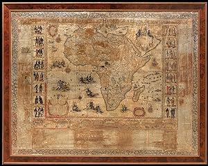
Africa.
Verlag: Willem Blaeu, 1608 [but 1612]., Amsterdam,, 1608
Anbieter: Daniel Crouch Rare Books Ltd, London, Vereinigtes Königreich
Verbandsmitglied: ABA ILAB PBFA
Bewertung:
Karte
Blaeu's monumental wall map of Africa Large engraved wall map, on four sheets joined, with traces of original colour, decorative boarder of the local populace, and major ports, together with descriptive text, title in manuscript, and engraved foliate border, some significant loss to map and text. Blaeu's landmark map of Africa, which was "of such importance that for the next 100 years numerous mapmakers throughout Europe. copied [it] in both design and content" (Betz). The map of Africa depicts the European conception of the continent at the dawn of the seventeenth century, an especially interesting juncture when the coastlines were well-explored, but its heart remained an enigma. Blaeu was influenced by Giacomo Gastaldi's large map of 1564, which was copied in Antwerp by Cornelis De Jode, as well as Abraham Ortelius's maps of 1595. He also considered the maps present in Filippo Pigafetta's book on the Congo, based on the explorations of Duarte Lopes (1591) and the map included in the second edition of Giovanni Battista Ramusio's 'Navigatione et Viaggi' (1550), in addition to Portuguese sources included in Jan Huygens van Linschoten's 'Itinerario' (1596). In west Africa, Blaeu depicted territorial divisions similar to Gastaldi and Ortelius, labelling both Barbaria and Libya Interior. The Niger and Senegal Rivers combine to flow into the Atlantic as one great system, with an apocryphal Lake Niger being the source for the latter. The great entrepot of Tombotu (Timbukto) is shown and the Gold Coast is based on a map by Luis de Texiera, which found its way to Amsterdam in 1602. Central Africa is derived from Ortelius and Pigafetta, and South Africa is updated by the inclusion of Dutch nomenclature, like "Mossel baij", from the work of Cornelis De Houtman (1595-97). The southern interior is based on Portuguese sources, with the frontier fort "Cast[ellum] Portugal" labelled. The heart of the continent, at this point entirely unknown to Europeans, is derived from the ancient maps of Ptolemy. It shows both the sources of Nile and Zambezi Rivers as being lakes on other side of the mythical Mountains of the Moon. Abyssinia is taken from Ortelius's imaginative maps of the legendary Christian kingdom of Prester John. The map is lavishly decorated, with four cartouches, one playfully adorned with a monkey. Sea monsters inhabit the seas and elephants, rhinoceroses, camels and ostriches roam the continent. The side panels each feature vignettes depicting the peoples of different regions in what was thought to be their local costume, including the inhabitants of Senegal, Guinea, Gabon, the Congo, Madagascar, the Cape of Good Hope, Morocco, Malta, Tripoli, Algiers Ethiopia, Egypt, Abyssinia, and Mozambique, as well as a scene of pilgrims traveling to Mecca for the Hajj. Gerritsz derived his artistic inspiration from various sources including Theodore De Bry and the Italian mannerist draughtsman Enea Vico. The lower register features 12 bird's-eye views of towns taken from the early volumes of Braun and Hogenberg's 'Civitas Orbis Terrarum': Tangiers, Ceuta, Algiers, Tunis, Alexandria, Cairo, Quiloa (Mozambique), Mozambique Town, Sofala, Fort St. George of El Mina, the Canary Islands, and Safi (Morocco). Betz, The Mapping of Africa, 54 state 2.
-
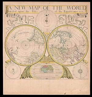
A New Map of the World Projected upon the Poles of the Equator By Will. Berry.
Verlag: Sold by Will Berry at the Signe of the Globe between Chearing-Cross and White-Hall, [c1680]., London,, 1680
Anbieter: Daniel Crouch Rare Books Ltd, London, Vereinigtes Königreich
Verbandsmitglied: ABA ILAB PBFA
Bewertung:
Karte
The first polar projection world map published by an Englishman Engraved map, fine original hand-colour, Ptolemaic, Tychonic, and Copernican diagrams of the solar system around map, map of the ancient world below. The first world map on polar projection to be published by an Englishman. Polar Projection Polar projection is a type of azimuthal projection based on a plane perpendicular to the Earth's axis through the poles. On polar-centered azimuthal projections, longitude is represented by radial straight lines, and latitude by concentric circles, or parallels. One of the earliest examples of a polar map of this kind is Mercator's 1569 world map, on which the Arctic is shown in an inset map on a polar projection, rather than included as part of the main image on the eponymous cartographer's projection. Other early double hemisphere world maps on north and south polar projections include Gerard De Jode's Hemispheriu ab Aequinoctiali Linea, 1593; Isaac Habrecht's map of 1628; Janssonius' Typus Orbis Terrarum from the same year; Jean Boisseau's Nouvelle Description de toute la terre universelle of 1640; and Novus Planiglobe Terrestris Per Utrumque Polum Conspectus, engraved by Joan Blaeu before 1672, the only extant example of which bears the later imprint of Gerard Valck, published around 1695. The present map by Berry is an example of the first map on polar projection to be published by an Englishman. The Map Published around 1680, Berry's map shows both the north and south hemispheres on a polar projection at a scale of approximately 1:100,000,000, with both extending to the equator, which is scaled. The coast of Australia is incomplete and California is shown as an island. Other cartographic myths include the massive single Great Lake and the Straits of Anian. The sizes of the Philippines and Japan are exaggerated, and the southern tip of South America has been truncated due to the projection. At first glance the work would appear to be a copy of Blaeu/Valck Novus Planiglobe Terrestris Per Utrumque Polum Conspectus; and although Berry's English title is an almost direct translation of Blaeu's work, it is no merely slavish copy. Berry has reversed the hemispheres, and significant cartographic differences are evident, especially in the depiction of South America. Surrounding the hemispheres are cosmological diagrams showing the Ptolemaic, Copernican and Tychonic solar systems, as well as a smaller map of the ancient world. This shows only Europe, Asia and Africa, and is divided into layers of "temperate zone", "frozen zone", "unhabitable" and "habitable by the Antients" regions. Ribbons ornament the upper left- and right-hand corners, streaming from the ends of the simple title banner along the upper edge. The map was engraved by John Rich, who also executed his road map of Great Britain the year before. William Berry (1639-1718) In his Printed Maps in the Atlases of Great Britain and Ireland, 1579 1870, Thomas Chubb describes Berry as a bookseller, geographer, and engraver, who was active between about 1670 and 1703. Berry was the son of a Warwickshire baker, probably apprenticed alongside his future partner Robert Morden (c1650-1703) to Joseph Moxon (1627 1691), an engraver, mapmaker, globe-maker and instrument-maker. His most enduring partnership was later with Morden, and together they sold topographical works, prints, maps, charts and globes. Among their shared works were A New Map of the English Plantations in America (1673), William Leybourn's An introduction to astronomy and geography: being a plain and easie treatise of the globes (1675), and Playing cards depicting the Counties (1676). In 1677 they petitioned the Attorney General for "a licence to do all general and particular maps of the several parts of the world according to an alphabetical manner and method first projected by them against any other undertakers". Although there are individual maps and globes prepared by the pair, the larger project never came to fruition, although Berry is best remembered, as the "English Sanson", for the set of maps of the world that he corrected and amended after Nicolas Sanson, which were issued separately between 1680 and 1689. Rare we are only able to trace one institutional example, held at The Library of Congress, and a smaller facsimile at the British Library. Not in Shirley; LC G3200 1675 .B4.
-
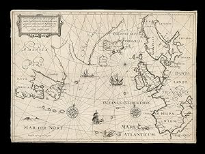
Caerte vande gehele voiage des Experiments vanden Regel, des Gesichts des Grooten Zee-vaerts, gedaen doer Ordere, vande H°. Mog: Heeren Staten Generael, inden Faere onses Heeren Ao 1618.
Verlag: Dierick Alberts, c1618]., ?[Leeuwarden, 1618
Anbieter: Daniel Crouch Rare Books Ltd, London, Vereinigtes Königreich
Verbandsmitglied: ABA ILAB PBFA
Bewertung:
Karte
Jarichs' Solution to the Longitude Problem Engraved chart, trimmed to neatline, a few nicks and small tears to margins skilfully repaired, very minor loss to old folds. Exceptionally rare map of the North Atlantic tracking an experimental voyage conducted to test a new theory of longitude and latitude. Almost nothing is known about the early life of Dutch cartographer Nicolaas Geelkercken, with Scherpenzeel, Zutphen and Geilenkirchen each variously posited as a potential birthplace. He first appears in the records in 1600, when he produced a picture of the Castle of Verwolde, leading to a suggested year of birth of around 1585; this was then followed by a ten-year gap before he reappears in Leiden as a draughtsman, engraver, publisher and surveyor. Throughout his career, Geelkercken engraved at least 169 maps and plans, as well as several views and portraits, and operated in Leiden, Amsterdam and Arnhem, where his business was eventually inherited by his son Isaak in 1656. Among Geelkercken's most important works were two world-maps produced at the outset of his career, a huge map of Pomerania measuring 1250 by 2170mm, and a map of Palestine decorated with ten detailed depictions of Biblical scenes. Until recently the present chart, engraved by Geelkercken in 1618, was unrecorded, and its origins remain something of a mystery. Focused on the North Atlantic and the surrounding lands, it illustrates a voyage undertaken in to test a new method for identifying longitude, suggested by Jan Hendricksz Jarichs van der Ley in 1615. The growth of European empires during the sixteenth and seventeenth centuries meant that new importance was placed on the sailing power and prowess that facilitated overseas trade and travel. There was therefore a rush to find an accurate and reliable method of calculating longitude while at sea, with the British Parliament offering rewards of up to Ł20,000 for successful innovations. The States General and the States of Holland also sponsored a prize for a solution to this ongoing problem, which had resulted in the loss of several Dutch ships in treacherous foreign waters. Alongside applicants such as Galileo Galilei and Christiaan Huygens was Jan Hendrick Jarichs van der Ley, a mathematician and Receiver General, or tax collector. In 1615, Jarichs presented his idea in 'Het gulden zeeghel'. It involved using trigonometric calculations, which were only just beginning to be be applied in navigation, to check the estimated latitude by simple astronomical observations. Although compounded errors could still result in significant inaccuracies, Jarichs' solution reached the trial stage of the research after he presented the States General with his innovative charts showing parallels, meridians and rhumb lines on his own version of a stereographic projection. The present chart displays just such a network of curved lines. Although his method was criticised by some of the government's experts, including Blaeu, it nonetheless secured a trial run. The Bruyn-Visch set sail from Holand under Captain Joris Carolus, a Dutch cartographer and pilot; after voyaging to Iceland via Scotland, it skirted the northeast coast of Greenland before returning from Newfoundland via the Azores, making home port five months after its departure. The complete journey is recorded on the present chart. During the voyage, they had been able to plot coordinates for several landfalls more accurately than previously charted, but there remained substantial errors. Nevertheless, Jarichs persisted with his method, preparing a small booklet entitled 'Gesicht des grooten zeevaerts' for the States General in 1619 detailing the successes of the trial. The following year a small panel official endorsed Jarichs' method, and consequently the States General allowed Jarichs a twelve-year privilege for an account of the voyage. 'Voyage van[']t experiment vanden generalen regul des Gesichts vande groote zeevaert' was published the same year. Jarichs thus became the only applicant who ever received reward from the Dutch government on account of his work on the longitude problem, even though his method never came into general use. Engraved in 1618 after the completion of the voyage, Geelkercken's chart shows parts of New France in the west, including Canadensis and Terra Nova, with its coastline are drawn in grey rather than black to indicate that they were as yet unchartered territories. Greenland is outlined, as is the Davis Strait, Iceland and the mythical island of Friesland, as well as the British Isles and Continental Europe as far south as Spain. The very north-western swathes of Africa, labelled "Barbarien", are shown in the lower right-hand corner. The waters are adorned with illustrative ships and sea-creatures, along with two ornate compass roses. The title of the chart, which explains that it was "executed by Order of the High and Mighty Gentlemen of the States General", indicates that it is likely to have been ordered as part of an official report on Jarichs' trial. Other sources have suggested, however, that the chart was included in his books, although no extant copies of either the 'Gesicht' or 'Voyage' contain it. Likewise, although some have suggested 's-Gravenhage as the place of publication, it is more likely that this map was published in Leeuwarden by Dierick Alberts, as was the case for several other works by Geelkercken at the time. Overall, this extremely rare chart offers unique insight into one of the suggested solutions to the longitude problem that would continue to befuddle European navigators for over one hundred years. The only other recorded example of the chart, is according to Burden housed in a private American collection. Keuning, Johannes, (1967), 'Nicolaas Geelkerken', Imago Mundi (11) p174-7; Burden, America Addenda, 193a.
-
Splendor Magnificentissimae Urbis Venetiarum Clarissimus; E Figuris elegantissimis, and accurata Descriptione emicans; In Duas Partes distributus.
Verlag: Leiden Pieter van der Aa c, 1720
Anbieter: Shapero Rare Books, London, Vereinigtes Königreich
Verbandsmitglied: ABA ILAB PBFA
Bewertung:
Buch
2 parts in one vol., folio (45 x 29 cm); half-titles, titles printed in red and black with engraved vignettes, large folding bird's-eye view of Venice and large folding plan (both after Blaeu), a further 115 double-page engraved plates, captioned in Italian, Latin and French, light spotting and toning, predominantly to text leaves, occasionally affecting plate margins (particularly in part II), but generally plates clean and fresh; 1830's half brown morocco over marbled boards, spine with 5 raised bands, gilt-ruled in compartments, gilt lettering to second compartment, some rubbing to boards and extremities, else a very good copy. A rare and lavishly illustrated work devoted entirely to the city of Venice, issued as part of the monumental Thesaurus antiquitatum et historiarum Italiae. The impressive views, including both the magnificent folding panorama and folding plan of the city after Blaeu, reproduce not only the art and architecture of Venice but also the festivities, such as carnival, public boxing, canal regattas, bullfighting, and fireworks. Published by Pieter van der Aa (1659-1733), a famous Dutch publisher of maps and atlases active in the late 17th and early 18th centuries. The present work contains 115 double-page engravings, some after the most famous artists of the time including Carlevarijs and Canaletto. Graesse VI, 472.
-
Novus Atlas Sinensis. A Martino Martinio. Eerste Deel van't Negende Stuck der Aerdycks Beashryving.
Erscheinungsdatum: 1655
Anbieter: Altea Antique Maps, London, Vereinigtes Königreich
Verbandsmitglied: ABA ILAB PBFA
Bewertung:
Amsterdam, 1655, Dutch edition. Folio; full vellum; two coloured engr. titles with gold highlights, pp. [iv] + 212 + 40 + xviii + [20]; 17 maps in excellent original colour. A very fine example of Blaeu's influential Atlas of China, the first Western atlas devoted to that country, with maps compiled by Father Martino Martini (1614-61), a Jesuit missionary. In the preface Martini claimed to have visited seven of the fifteen Chinese provinces, although he does not say which ones. His maps (a general map of China and Japan, 15 provinces and a more detailed map of Japan) were far in advance of any available in the West, and this atlas remained the standard georgraphical work on China until 1737, when D'Anville published his 'Atlas de la Chine'. KOEMAN: Bl 57, as part of the 'Atlas Major'.
-
BAYERN. - Trachten. LIPOWSKY, Felix Joseph. Sammlung bayerischer National-Costume mit historischem Text.
Verlag: Mchn., Hermann und Barth, um, 1828
Anbieter: Peter Bierl Buch- & Kunstantiquariat Inh.: Andrea Bierl, Eurasburg, Deutschland
Bewertung:
Folio. Lithogr. Titel, 52 S. Text und 49 altkolorierte Lithographien von Albrecht Adam, Lorenzo Quaglio u.a. Französ. Halbmaroquin mit eingebundenem blauem Original-Umschlag mit königlichem bayerischen Wappen und Ornamenten in Silberprägung. Lipperheide 755; Vinet 2154 (48 Tafeln); Pfister II,2769; Lentner 3651: "Vollständige Exemplare dieses schönen und wichtigen Kostümwerkes sind sehr selten!". - Das prachtvolle Kostümwerk auf starkem Papier und in blütenfrischer Erhaltung. Komplette Exemplare sind eine Rarität ersten Ranges. - Das vorliegende Exemplar zeichnet sich zudem durch eine perfekte und sehr differenzierte Kolorierung aus: die Trachtenfiguren sind ausdrucksvoll und kräftig koloriert, die Hintergrund-Landschaften zart und durchsichtig. Der blaue Originalumschlag mit silbernem Wappen lässt auf eine königliche Provenienz schließen. Das Werk, Ausdruck eines unter den Königen Max I. Joseph und Ludwig I. nach den Napoleonischen Kriegen neu erwachten Nationalgefühls, erschien in Lieferungen von zwölf Heften mit je vier Tafeln. Hier die letzte Lieferung mit der meist fehlenden 5. Tafel "Bauernmädchen aus Frommersbach im Spessarter Walde". Diese Tracht weist orientalischen Einfluss auf und wurde wegen des Gelübdes bei der die Pest von 1483 (was heißt das ???) "für ewige Zeiten beibehalten". Neben den schönen Trachten aus Ober- und Niederbayern, Bayerisch-Schwaben und Franken sind auch Volksbräuche dargestellt wie der Schäfflertanz und der Metzgersprung in München, das Pferderennen auf dem Oktoberfest, das Hochzeitsmahl in einer Schenke zu Schliersee, das Vogelschießen zu Regensburg, der Kirchweihtanz zu Oberndorf in Franken oder die Hopfenernte bei Straubing.
-
Sedes Belli of De Stoel des Oorlogs in den Landen. Van Braband, Gelderlandt, Kleef en Luykerland &.
Verlag: Amsterdam, Johannes Covens & Cornelis Mortier, 1740
Anbieter: Antiquariaat de Roo, Zwijndrecht, Niederlande
Bewertung:
The first wall map of the Seven Provinces of 1651, re-issued as 'Stoel des Oorlogs' by Covens & Mortier. Size 136,5 x 172 cm. The first issue of the present wall-map is known to be included in the Klencke Atlas in the British Library; the second edition, by son Dancker Danckerts, is present in the other two giant atlases: the Mecklenburg Atlas in Rostock and the Atlas des Grossen Kurfürsten in Berlin. After Nicolaas Visscher published a third state of this decorative piece it was the firm of Covens & Mortier who sold this fourth and final state of the map. Presumably commemorating the 1648 treaty and the Republic's independence, this map might be considered to be a peace-counterpart of the monumental 21-sheet world map that was published by Joan Blaeu in 1648. This historical context, also unveiled by the many decorative and symbolical references, hardly applied to the Covens & Mortier era. However, the new 'Stoel des Oorlogs' title and some minor changes were a poor attempt to bring it more or less up-to-date and fit it into the popular 'Théâtre de la guerre' category. This map, like those in the giant atlases, is a good example of the few surviving cartographic treasures.
-

Brief Traict, ou maniment. DżAulcuns (mais principaulx) usages, et observations des deux Globes, Celeste et Terrestre: Ensemble LżExplication de tous les Cercles, Linees, Instruments, et aultres Verbis-Artis, y appartenant, mises, escriptes, et Dedié.
Verlag: Brussels, 1617
Anbieter: Martayan Lan, New York, NY, USA
Bewertung:

Hardcover. Zustand: Very Good. French manuscript written in brown ink in a French cursive hand, pages ruled in red, 21 lines per page. 15.3 cm x 9.5 cm, (58) pp. Bound in contemporary limp vellum with remains of green silk ties. A presentation copy with the dedicateeżs name left blank. Clean and fresh, an excellent copy. Very rare manuscript userżs manual for the famous terrestrial and celestial globes by the van Langren cartographic dynasty, notable as the first to employ the highly accurate star observations of the żtresfameuxż Tycho Brahe ż whose contribution is duly acknowledged (fol. 9v). Well into the age of print, these manuals were handwritten rather than printed because the globes which they accompanied were luxury articles and relatively few were produced, notwithstanding their importance. The celestial globes of Van Langren (1594), and later Blaeu, soon rendered Mercatorżs great globes obsolete. As early as 1590, the young Arnold van Langren was sent to Hven to take advantage of what was at the time the most advanced celestial observatory in Europe. żWhen Arnold came to Uraniborg, Tychożs plan to publish his stellar positions was already formulated, but the observations and calculations that resulted in the catalogue of 777 stars had not been completed. While Tycho could have provided Arnold van Langren with the newly calculated positions of some stars, perhaps even interim locations for most of them, it seems quite likely that he would have advised the Dutchman to await the completion of this work before beginning a globus Tychonicus. He may even have withheld his consent at this stage.ż (Adam Mosley, Bearing the Heavens, p. 240). Tychożs own Progymnasmata also makes reference to the visit: żJacob Floris, citizen of Amsterdam, a great expert in the making of celestial and terrestrial Globes, having sent here his son, skilled in the construction of the same, decided to prepare a certain celestial globe following this rectification of ours of the places of the Fixed Sars, which in its certainty and skillful elaboration is about to greatly surpass those hitherto employed.ż The present guide directs the user in the workings of both Langrenżs celestial and terrestrial globes, giving both a general introduction and practical working examples in solving geodetic and astronomical problems. According to van der Krogt, the van Langren manuals are based in part on Robert Huesż Tractaet ofte Handlinge van het gebruijck der Hemelscher ende Aertscher globe (1st ed Amsterdam, 1597), and are in part original. żAmong other things, van Langren makes use of a separate żgnomon sphareiconż (sphaerical angle bar), a small instrument which makes it possible to place a perpendicular line easily on the spherical globeż. On f4r Langren discusses the astronomical implcations of the recent calendar reform under Gregory XIII, while on 11r he mentions the influential mentor of Tycho, Landgrave Wilhelm of Hesse-Kasselżs method of observing stars by their almucantar and azimuth ż a procedure which would later become adopted as the standard method for determining stellar positions. Langren also here explains his decision to include the 32 winds by which modern navigators divide up the sky, which are apparently noted on the globe in Flemish. Despite other similar references to the recent advances of Pedro Nunes (23v), and Tycho Brahe, the present manuscript is above all a practical rather than theoretical guide to the use of the globes in understanding celestial and terrestrial mechanics. Imperative instructions - żtournez vostre Globe ainsiżż żCherchez sur le Globe le degre du Soleilżż ż evidently enabled the user to manipulate his globes with or without an instructor present. .
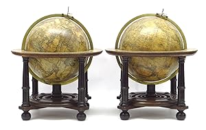
![Bild des Verkäufers für [Pair of nine-inch table globes]. zum Verkauf von Daniel Crouch Rare Books Ltd](https://pictures.abebooks.com/inventory/md/md30793851685.jpg)
![Bild des Verkäufers für Kunyu quantu [A Complete Map of the World]. zum Verkauf von Daniel Crouch Rare Books Ltd](https://pictures.abebooks.com/inventory/md/md30793851691.jpg)
![Bild des Verkäufers für West-Indische Paskaert waer in de graden der breedde over wederzijden van de middellijn wassende so vergrooten dat die geproportioneert sijn tegen hunne nevenstaende graden de lengde. Vertonende behalve[n] Europaes zuydelijcste alle de zeekusten van Africa en America begrepen in 't Octroy bij de H.M.H. Staten Generael der vereenichde Nederl. verleent aende Generale West Indische Compagnie. Mitsgaders die van Peru en Chili inde groote Zuyd-Zee. zum Verkauf von Antiquariat INLIBRIS Gilhofer Nfg. GmbH](https://pictures.abebooks.com/inventory/md/md31041533701.jpg)
![Bild des Verkäufers für West-Indische Paskaert waer in de graden der breedde over wederzijden van de middellijn wassende so vergrooten dat die geproportioneert sijn tegen hunne nevenstaende graden de lengde. Vertonende behalve[n] Europaes zuydelijcste alle de zeekusten van Africa en America begrepen in 't Octroy bij de H.M.H. Staten Generael der vereenichde Nederl. verleent aende Generale West Indische Compagnie. Mitsgaders die van Peru en Chili inde groote Zuyd-Zee.Amsterdam, Pieter Goos, [ca. 1660]. Printed on vellum (ca. 80 x 98 cm) from one large copperplate engraving, partly coloured by a contemporary hand. zum Verkauf von Antiquariaat FORUM BV](https://pictures.abebooks.com/inventory/md/md30997380315.jpg)
![Bild des Verkäufers für [Chart of the West Coast of Saudi Arabia and the Red Sea]. zum Verkauf von Daniel Crouch Rare Books Ltd](https://pictures.abebooks.com/inventory/md/md30793857173.jpg)
![Bild des Verkäufers für [Terrestrial globe]. In ista quam exhibemus Terreni Globi descriptione omnium regionum juxta et insularum . zum Verkauf von Bruce Marshall Rare Books](https://pictures.abebooks.com/inventory/md/md30778535852.jpg)
![Bild des Verkäufers für Atlas maior. Amsterdam, Johannes Covens & Cornelis Mortier, [ca. 1725]. Imperial folio (53 x 35.5 cm). With engraved title-page and 76 double page (or in 8 cases larger folding) engraved maps, the title-page and all maps and their decorations coloured by a contemporary hand. Half tanned sheepskin (ca. 1900), gold-tooled spine. zum Verkauf von ASHER Rare Books](https://pictures.abebooks.com/inventory/md/md30059007522.jpg)
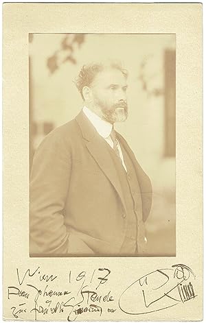
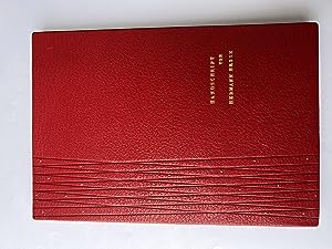
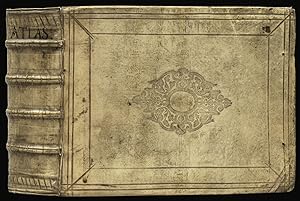
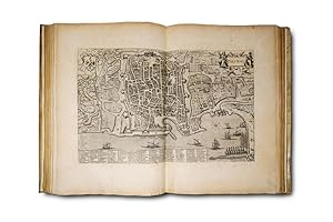
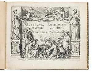
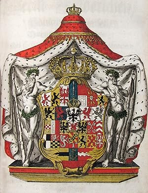
![Bild des Verkäufers für [A set of the world and four continents]. Nova Totius Terrarum Orbis Geographica ac Hydrographica; Europa recens descripta; Africae nova descriptio; Asia noviter delineata; Americae nova Tabula. zum Verkauf von Daniel Crouch Rare Books Ltd](https://pictures.abebooks.com/inventory/md/md21465493832.jpg)