Beschreibung
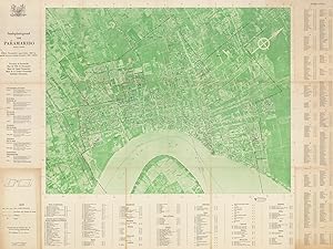
Bi-chrome photolithograph (black and green), with contemporary manuscript annotations in blue and orange pencil crayon (Good, some wear and toning along old folds, some toning and light staining to outer panels, a few closed marginal tears), 75 x 99 cm (29.5 x 39 inches). SURINAM PARAMARIBO / AERIAL CARTOGRAPHY: An intriguing late colonial era map of Paramaribo, Surinam, in the form of an aerial photograph of the city tinted in green superimposed with information identifying all streets, 208 named key sites, neighborhoods, railways, and bus and ferry routes; created by the colony s foremost geographer and geologist, Henk Dahlberg, working for the Surinam s Central Bureau of Air Mapping and employing the advanced methods of 'Controlled Mosaic aerial cartography, published in Paramaribo by the Topographische Dienst surprisingly rare. This unusual and intriguing map of Paramaribo, the capital of Curinam, captures the city in the late 1950s, during the twilight years of the Dutch colonial era (Surinam would gain its independence in 1975). The busting port, located along a sharp bend on the Surinam River, then had, as noted upon the map, a land area of 1868 hectares and a population of 108,416 (December 1958). The area had been settled by Europeans since the first Dutch colonists arrived in 1613 and became the colonial capital in 1667 when Surinam officially became a Dutch colony. Paramaribo became an affluent and culturally diverse mart of commerce, fueled by the ignoble slave-sugar economy. Since the abolition of slavery, which occurred in a graduated fashion between 1863 and 1873, Paramaribo continued to thrive as the colony s agrarian sector remained viable, in part due to the importation if labourers from Asia, while gold mining in the interior increasingly provided more revenue. When the present map was made, Paramaribo was a small but vibrant city full of attractive wooden colonial buildings. However, discontent lay just below the surface, as the Dutch regime became increasingly unpopular, leading to Surinam s independence and the tumultuous years that followed. Curiously, the map comes in the form of an aerial photograph, tinted in green, with a vast quantity of information overlaid in black text, including the labelling all streets, key sites, neighborhoods, and railways, and bus and ferry routes. The map was made by Henk N. Dahlberg, Surinam s leading geographer and geologist, who was then fulfilling a commission for the Centraal Bureau Luchtkaartering, Suriname [Central Bureau of Air Mapping, Surinam], an agency formed in the wake of World War II whose mandate was to map Surinam using advanced techniques of controlled mosaic aerial cartography. To the right of the map is a street index, while the key, bottom centre, lists 208 named sites, as noted by number on the map, classified as crown ministries, public services, banks, cemeteries, libraries, cinemas, clubs and bars, consulates, hotels, factories, hospitals, churches and temples, airline offices, mining offices, museums, radio stations, shipping lines offices, schools, sporting venues, tourism offices and miscellaneous sites. SEE OUR WEB PAGE FOR A LONGER DESCRIPTION. Bestandsnummer des Verk�ufers 69781
Verk�ufer kontaktieren
Diesen Artikel melden

