


Long Island Rail Road Map
Metropolitan Transit Authority (MTA)
Verlag: Metropolitan Transit Authority, New York, 1989
Gebraucht
Verk�ufer
Argosy Book Store, ABAA, ILAB, New York, NY, USA
Verk�uferbewertung 5 von 5 Sternen
![]()
Heritage Bookseller
AbeBooks-Mitglied seit 1996
Dieses Exemplar ist nicht mehr verf�gbar. Hier sind die �hnlichsten Treffer f�r Long Island Rail Road Map.
Beschreibung
Beschreibung:
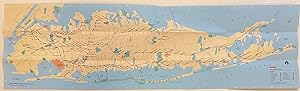
Pocket map. Color lithograph. Sheet measures 35 1/4 x 10 1/8", folded measures 8 3/4" x 3 1/2" This LIRR map issued in 1989 features a colorful map of New York City and Long Island. Railroad branches and stations are prominently labeled, and major roads and highways are also shown. Airports and parks are distinctively colored. Verso includes index of LIRR stations and travel connections; subway connections with three inset maps showing subway lines around Penn Station, Jamaica Station, Flushing, Woodside, and Hunters Point connections, and Flatbush Avenue Terminal; and places of interest with their respective locations and phone numbers. Bestandsnummer des Verk�ufers 308619
Bibliografische Details
Titel: Long Island Rail Road Map
Verlag: Metropolitan Transit Authority, New York
Erscheinungsdatum: 1989
Beste Suchergebnisse beim ZVAB

Foto des Verk�ufers
'SCARBOROUGH'S NEW RAIL-ROAD, POST OFFICE, TOWNSHIP, AND COUNTY MAP OF NEW YORK WITH DISTANCES BETWEEN STATIONS.'. Large and detailed folding (wall) map of the State of New York with two inset maps of Long Island and the City of New York. Published in Boston by the
Verlag:
Scarborough Company 1903, 1903
Gebraucht
Anbieter: Garwood & Voigt, Sevenoaks, Vereinigtes K�nigreich
Verk�uferbewertung 5 von 5 Sternen
![]()
Zustand: Fine. 101x114cm. Printed in full colours. Laid down on linen, not dissected. Occasional wear to crossfolds, otherwise excellent condition. Artikel-Nr. 27394
Gebraucht kaufen
EUR 536,61
EUR 34,73 Versand
Versand von Vereinigtes K�nigreich nach USA
Versand von Vereinigtes K�nigreich nach USA
Anzahl: 1 verf�gbar