Inhaltsangabe
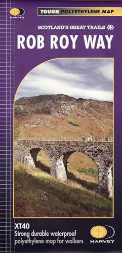
Rob Roy Way is a walk across part of the Southern Highlands of Scotland taking in some of the most beautiful countryside in the UK. Starting from Drymen it goes north east to finish in Pitlochry. The Way is 77mls or 94 mls (124Km or 151Km) depending on your route choice. The tracks and paths you follow were used by Rob Roy MacGregor in the 17th & 18th centuries, other historical characters throughout the Jacobite uprisings and during the feuds between the local clans. Places you will pass through include Aberfoyle, Callander, Strathyre, Killin or Amulree and Aberfeldy. Lochs you will walk along include Venachar, Lubnaig and Tay passing by Ben Ledi, Ben Chonzie and Ben Lawers. XT40 New generation of tough polyethylene maps. The HARVEY series of Long Distance Route maps is an established success. Now the advanced technology used in the creation of our best-selling British Mountain Maps is also applied to the route maps. These maps are a leap forward in technical excellence. They are tough, durable, light and 100% waterproof virtually indestructible in normal use. They are light to carry, and compact not the great bulky package you get with a laminated map. The map is detailed, with the routes clearly marked. It also contains general information, useful telephone numbers and a full key.
Die Inhaltsangabe kann sich auf eine andere Ausgabe dieses Titels beziehen.
Suchergebnisse f�r Rob Roy Way: XT40 (Trail Map XT40)

Beispielbild f�r diese ISBN
Rob Roy Way
Anbieter: PBShop.store UK, Fairford, GLOS, Vereinigtes K�nigreich
Verk�uferbewertung 5 von 5 Sternen
![]()
UNK. Zustand: New. New Book. Shipped from UK. Established seller since 2000. Artikel-Nr. EA-9781851375196
Neu kaufen
EUR 20,16
EUR 3,82 Versand
Versand von Vereinigtes K�nigreich nach USA
Versand von Vereinigtes K�nigreich nach USA
Anzahl: 12 verf�gbar
Beispielbild f�r diese ISBN
Rob Roy Way: XT40
Anbieter: Revaluation Books, Exeter, Vereinigtes K�nigreich
Verk�uferbewertung 5 von 5 Sternen
![]()
Map. Zustand: Brand New. 1 pages. 9.61x4.69x0.24 inches. In Stock. Artikel-Nr. __1851375198
Neu kaufen
EUR 22,61
EUR 11,60 Versand
Versand von Vereinigtes K�nigreich nach USA
Versand von Vereinigtes K�nigreich nach USA
Anzahl: 1 verf�gbar
Beispielbild f�r diese ISBN
Rob Roy Way
Verlag:
Harvey Map Services Ltd, 1819
ISBN 10: 1851375198
ISBN 13: 9781851375196
Gebraucht
Paperback
Anbieter: WorldofBooks, Goring-By-Sea, WS, Vereinigtes K�nigreich
Verk�uferbewertung 5 von 5 Sternen
![]()
Paperback. Zustand: Good. The book has been read but remains in clean condition. All pages are intact and the cover is intact. Some minor wear to the spine. Artikel-Nr. GOR008401277
Gebraucht kaufen
EUR 27,72
EUR 6,50 Versand
Versand von Vereinigtes K�nigreich nach USA
Versand von Vereinigtes K�nigreich nach USA
Anzahl: 1 verf�gbar
Beispielbild f�r diese ISBN
Rob Roy Way
Verlag:
Harvey Map Services Ltd, 1819
ISBN 10: 1851375198
ISBN 13: 9781851375196
Gebraucht
Paperback
Anbieter: WorldofBooks, Goring-By-Sea, WS, Vereinigtes K�nigreich
Verk�uferbewertung 5 von 5 Sternen
![]()
Paperback. Zustand: Very Good. The book has been read, but is in excellent condition. Pages are intact and not marred by notes or highlighting. The spine remains undamaged. Artikel-Nr. GOR008664157
Gebraucht kaufen
EUR 27,72
EUR 6,50 Versand
Versand von Vereinigtes K�nigreich nach USA
Versand von Vereinigtes K�nigreich nach USA
Anzahl: 1 verf�gbar
Beispielbild f�r diese ISBN
Rob Roy Way
Anbieter: Ria Christie Collections, Uxbridge, Vereinigtes K�nigreich
Verk�uferbewertung 5 von 5 Sternen
![]()
Zustand: New. In. Artikel-Nr. ria9781851375196_new
Neu kaufen
EUR 22,83
EUR 13,90 Versand
Versand von Vereinigtes K�nigreich nach USA
Versand von Vereinigtes K�nigreich nach USA
Anzahl: 1 verf�gbar
Beispielbild f�r diese ISBN
Rob Roy Way: XT40
Anbieter: Revaluation Books, Exeter, Vereinigtes K�nigreich
Verk�uferbewertung 5 von 5 Sternen
![]()
Map. Zustand: Brand New. 1 pages. 9.61x4.69x0.24 inches. In Stock. Artikel-Nr. zk1851375198
Neu kaufen
EUR 32,75
EUR 11,60 Versand
Versand von Vereinigtes K�nigreich nach USA
Versand von Vereinigtes K�nigreich nach USA
Anzahl: 1 verf�gbar
Beispielbild f�r diese ISBN
Rob Roy Way
Anbieter: Kennys Bookstore, Olney, MD, USA
Verk�uferbewertung 5 von 5 Sternen
![]()
Zustand: New. 2012. Map. BIC Classification: 1DBK; WSZC; WTRM. Category: (G) General (US: Trade). Dimension: 241 x 132 x 6. Weight in Grams: 76. . . . . . Books ship from the US and Ireland. Artikel-Nr. V9781851375196
Neu kaufen
EUR 40,41
EUR 9,23 Versand
Versand innerhalb von USA
Versand innerhalb von USA
Anzahl: 1 verf�gbar
Beispielbild f�r diese ISBN
ROB ROY WAY
Anbieter: Speedyhen, Hertfordshire, Vereinigtes K�nigreich
Verk�uferbewertung 5 von 5 Sternen
![]()
Zustand: NEW. Artikel-Nr. NW9781851375196
Neu kaufen
EUR 18,66
EUR 47,56 Versand
Versand von Vereinigtes K�nigreich nach USA
Versand von Vereinigtes K�nigreich nach USA
Anzahl: 1 verf�gbar
Foto des Verk�ufers
Rob Roy Way
Anbieter: moluna, Greven, Deutschland
Verk�uferbewertung 5 von 5 Sternen
![]()
Zustand: New. KlappentextrnrnSPORTS & RECREATION / Walking. Artikel-Nr. 598791369
Neu kaufen
EUR 26,20
EUR 48,99 Versand
Versand von Deutschland nach USA
Versand von Deutschland nach USA
Anzahl: 1 verf�gbar
Foto des Verk�ufers
Rob Roy Way
Anbieter: AHA-BUCH GmbH, Einbeck, Deutschland
Verk�uferbewertung 5 von 5 Sternen
![]()
Karte. Zustand: Neu. Neuware - Rob Roy Way is a walk across part of the Southern Highlands of Scotland taking in some of the most beautiful countryside in the UK. Starting from Drymen it goes north east to finish in Pitlochry. The Way is 77mls or 94 mls (124Km or 151Km) depending on your route choice. The tracks and paths you follow were used by Rob Roy MacGregor in the 17th & 18th centuries, other historical characters throughout the Jacobite uprisings and during the feuds between the local clans. Places you will pass through include Aberfoyle, Callander, Strathyre, Killin or Amulree and Aberfeldy. Lochs you will walk along include Venachar, Lubnaig and Tay passing by Ben Ledi, Ben Chonzie and Ben Lawers. XT40 New generation of tough polyethylene maps. The HARVEY series of Long Distance Route maps is an established success. Now the advanced technology used in the creation of our best-selling British Mountain Maps is also applied to the route maps. These maps are a leap forward in technical excellence. They are tough, durable, light and 100% waterproof virtually indestructible in normal use. They are light to carry, and compact not the great bulky package you get with a laminated map. The map is detailed, with the routes clearly marked. It also contains general information, useful telephone numbers and a full key. Artikel-Nr. 9781851375196
Neu kaufen
EUR 24,45
EUR 60,37 Versand
Versand von Deutschland nach USA
Versand von Deutschland nach USA
Anzahl: 1 verf�gbar