Verwandte Artikel zu London Mini A-Z Street Atlas (paperback) (London Street...
Inhaltsangabe
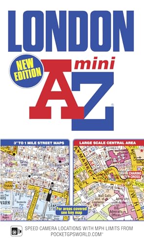
This pocket sized A-Z Mini map of Central London is a full colour, paperback street atlas covering an area extending from the centre of London to:
•Brent Cross
- Golders Green
- Highgate
- Finsbury Park
- Stoke Newington
- Leytonstone
- Wanstead
- West Ham
- Thames Flood Barrier
- Eltham
- Grove Park
- Catford
- Streatham
- Wimbledon
- Barnes Bridge
- Willesden Junction
- Neasden
In addition, there is a large-scale street map section of the inner London area which extends north to Regent's Park and Shoreditch, south to London Victoria station and Lambeth, west to Hyde Park and east to Tower Bridge.
One-way streets and safety camera locations with their maximum speed limit are featured on both scales of street mapping.
The congestion charging zone boundary is shown on both scales of mapping and there is also an overview map of the congestion charging zone. The London Underground Map is featured within the atlas and on the outside back cover is a central London Underground Map.
The comprehensive index lists streets, selected flats, walkways and places of interest, place, area and junction names. There are separate index listings for both hospitals, walk-in centres and hospices and for the National Rail, London Tramlink, Docklands Light Railway, London Underground and Overground stations and River Bus piers covered by this atlas.
Die Inhaltsangabe kann sich auf eine andere Ausgabe dieses Titels beziehen.
�ber die Autorin bzw. den Autor
Geographers’ Map Company Ltd. (A-Z Maps) was established in London on 25 August 1936. The company’s most famous publication, the iconic A-Z Atlas and Guide to London, was created by Phyllis Pearsall, the founder of A-Z, who explored every street in London to create the first edition. Since then, A-Z has become the trusted source for street maps and atlases, as well as developing Visitors’ Guides, Road Atlases and the Adventure Map series for walkers.
��ber diesen Titel� kann sich auf eine andere Ausgabe dieses Titels beziehen.

EUR 1,88
EUR 4,04 f�r den Versand von Vereinigtes K�nigreich nach Deutschland
Versandziele, Kosten & Dauer
Suchergebnisse f�r London Mini A-Z Street Atlas (paperback) (London Street...
Beispielbild f�r diese ISBN
London Mini A-Z Street Atlas (paperback) (London Street Atlases)
Verlag:
Geographers' A-Z Map Co Ltd, 2019
ISBN 10: 1843489058
ISBN 13: 9781843489054
Gebraucht
Paperback
Anbieter: WorldofBooks, Goring-By-Sea, WS, Vereinigtes K�nigreich
Verk�uferbewertung 5 von 5 Sternen
![]()
Paperback. Zustand: Fair. A readable copy of the book which may include some defects such as highlighting and notes. Cover and pages may be creased and show discolouration. Artikel-Nr. GOR009726463
Anzahl: 1 verf�gbar
Beispielbild f�r diese ISBN
Mini London Street Atlas (London Street Atlases)
Verlag:
Geographers' A-Z Map Co Ltd, 2019
ISBN 10: 1843489058
ISBN 13: 9781843489054
Gebraucht
Softcover
Anbieter: medimops, Berlin, Deutschland
Verk�uferbewertung 5 von 5 Sternen
![]()
Zustand: very good. Gut/Very good: Buch bzw. Schutzumschlag mit wenigen Gebrauchsspuren an Einband, Schutzumschlag oder Seiten. / Describes a book or dust jacket that does show some signs of wear on either the binding, dust jacket or pages. Artikel-Nr. M01843489058-V
Anzahl: 2 verf�gbar
Beispielbild f�r diese ISBN
Mini London Street Atlas (London Street Atlases)
Verlag:
Geographers' A-Z Map Co Ltd, 2019
ISBN 10: 1843489058
ISBN 13: 9781843489054
Gebraucht
Softcover
Anbieter: medimops, Berlin, Deutschland
Verk�uferbewertung 5 von 5 Sternen
![]()
Zustand: good. Befriedigend/Good: Durchschnittlich erhaltenes Buch bzw. Schutzumschlag mit Gebrauchsspuren, aber vollst�ndigen Seiten. / Describes the average WORN book or dust jacket that has all the pages present. Artikel-Nr. M01843489058-G
Anzahl: 2 verf�gbar
Foto des Verk�ufers
London A-Z mini atlas
Verlag:
Geographers' A-Z Map Company Ltd, 2012
ISBN 10: 1843489058
ISBN 13: 9781843489054
Gebraucht
Softcover
Anbieter: Bookbot, Prague, Tschechien
Verk�uferbewertung 5 von 5 Sternen
![]()
Softcover. Zustand: As New. This pocket sized A-Z Mini map of Central London is a full colour, paperback street atlas covering an area extending from the centre of London to: -Brent Cross-Golders Green-Highgate-Finsbury Park-Stoke Newington-Leytonstone-Wanstead-West Ham-Thames Flood Barrier-Eltham-Grove Park-Catford-Streatham-Wimbledon-Barnes Bridge-Willesden Junction-NeasdenIn addition, there is a large-scale street map section of the inner London area which extends north to Regent's Park and Shoreditch, south to London Victoria station and Lambeth, west to Hyde Park and east to Tower Bridge.One-way streets and safety camera locations with their maximum speed limit are featured on both scales of street mapping.The congestion charging zone boundary is shown on both scales of mapping and there is also an overview map of the congestion charging zone. The London Underground Map is featured within the atlas and on the outside back cover is a central London Underground Map.The comprehensive index lists streets, selected flats, walkways and places of interest, place, area and junction names. There are separate index listings for both hospitals, walk-in centres and hospices and for the National Rail, London Tramlink, Docklands Light Railway, London Underground and Overground stations and River Bus piers covered by this atlas. Artikel-Nr. 5ba84a8d-b9cb-43dc-9443-298a9356499d
Anzahl: 1 verf�gbar
Beispielbild f�r diese ISBN
London Mini A-Z Street Atlas (paperback) (London Street Atlases)
Verlag:
HarperCollins Publishers, United Kingdom, 2019
ISBN 10: 1843489058
ISBN 13: 9781843489054
Gebraucht
Paperback
Anbieter: WorldofBooks, Goring-By-Sea, WS, Vereinigtes K�nigreich
Verk�uferbewertung 5 von 5 Sternen
![]()
Paperback. Zustand: Very Good. This pocket sized A-Z Mini map of Central London is a full colour, paperback street atlas covering an area extending from the centre of London to: Brent Cross Golders Green Highgate Finsbury Park Stoke Newington Leytonstone Wanstead West Ham Thames Flood Barrier Eltham Grove Park Catford Streatham Wimbledon Barnes Bridge Willesden Junction Neasden In addition, there is a large-scale street map section of the inner London area which extends north to Regent's Park and Shoreditch, south to London Victoria station and Lambeth, west to Hyde Park and east to Tower Bridge. One-way streets and safety camera locations with their maximum speed limit are featured on both scales of street mapping. The congestion charging zone boundary is shown on both scales of mapping and there is also an overview map of the congestion charging zone. The London Underground Map is featured within the atlas and on the outside back cover is a central London Underground Map. The comprehensive index lists streets, selected flats, walkways and places of interest, place, area and junction names. There are separate index listings for both hospitals, walk-in centres and hospices and for the National Rail, London Tramlink, Docklands Light Railway, London Underground and Overground stations and River Bus piers covered by this atlas. The book has been read, but is in excellent condition. Pages are intact and not marred by notes or highlighting. The spine remains undamaged. Artikel-Nr. GOR005516409
Anzahl: 3 verf�gbar
Beispielbild f�r diese ISBN
London Mini a-Z Street Atlas (paperback)
Verlag:
Geographers' A-Z Map Company, Limited, 2019
ISBN 10: 1843489058
ISBN 13: 9781843489054
Gebraucht
Softcover
Anbieter: Better World Books Ltd, Dunfermline, Vereinigtes K�nigreich
Verk�uferbewertung 5 von 5 Sternen
![]()
Zustand: Good. 10th Revised edition. Ships from the UK. Former library book; may include library markings. Used book that is in clean, average condition without any missing pages. Artikel-Nr. 17547616-20
Anzahl: 1 verf�gbar