
Gesamtpreis (1 Artikel Artikel):
Versandziel:

sicily sea (23 Ergebnisse)
Direkt zu den wichtigsten Suchergebnissen
Produktart
- Alle Produktarten
- Bücher (21)
- Magazine & Zeitschriften
- Comics
- Noten
- Kunst, Grafik & Poster
- Fotografien
- Karten (2)
-
Manuskripte &
Papierantiquitäten
Zustand
Einband
Weitere Eigenschaften
Gratisversand
Land des Verkäufers
Verkäuferbewertung
-

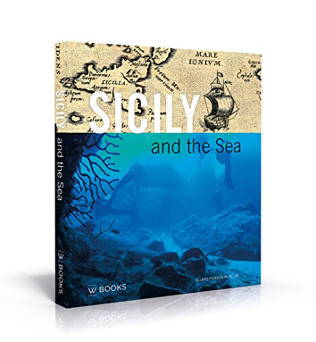
Mattanza : Love and Death in the Sea of Sicily
Verlag: Counterpoint Press, 2000
ISBN 10: 073820269XISBN 13: 9780738202693
Buch Erstausgabe
Zustand: Good. 1st. Used book that is in clean, average condition without any missing pages.
-
Paperback. Zustand: Fine.
Mehr Angebote von anderen Verkäufern bei ZVAB
Gebraucht ab EUR 42,62
-

Zustand: Good. Most items will be dispatched the same or the next working day.
-

Mattanza: Love and Death in The Sea of Sicily
Verlag: Perseus Books, Cambridge, 2000
ISBN 10: 073820269XISBN 13: 9780738202693
Anbieter: PsychoBabel & Skoob Books, Didcot, Oxfordshire, OXON, Vereinigtes Königreich
Bewertung:

Buch Erstausgabe
Hardcover. Zustand: Very Good. First Edition. Hardcover, 1st edition in unclipped dust jacket, very good condition. Minor scuffs to jacket edges and spine ends. Some light scoring to jacket. Clean and unmarked throughout. AD. Used.
-

Title: Mattanza Love and Death in the Sea of Sicily
Verlag: Counterpoint, 2000
ISBN 10: 0965323870ISBN 13: 9780965323871
Buch
Paperback. Zustand: Very Good. The book has been read, but is in excellent condition. Pages are intact and not marred by notes or highlighting. The spine remains undamaged.
-

Diese Veröffentlichung ist Teil einer ca. 25000 Titel umfassenden wissenschaftlichen Sammlung aus dem Gebiet der Geologie. Es handelt sich meist um Regionale Geologie, Mineralogie und Petrografie. Diese sind in verschiedene Kategorien unterteilt. Bitte sprechen Sie uns an! Z.B.: Dänemark/ Spitzbergen, Bären-Insel/ England, Schottland, Irland, Schweden, Finnland, Scandinavien allg., Österreich, Italien, Sizilien, Korsika, Elba, Pyrenäen, Spanien, Polen, Portugal, Russland, Tschechoslowakei, Rumänien, Bulgarien, Karpaten, Hawai usw. This publication is part of a large collection of scientific texts which deal with geology, mostly regionaly orientated. Please ask if you are interested in a list! Sprache: Englisch Gewicht in Gramm: 330.
-

La canzone del mare. The song of the sea Fruits of Sicily
Verlag: Gangemi editore, ROMA, 2013
ISBN 10: 8849227272ISBN 13: 9788849227277
Buch
Zustand: ECCELLENTE USATO. INTERLINGUE Legatura in tela con sovraccoperta plastificata. La coperta č in perfette condizioni, titoli al dorso poco leggibili. La sovraccoperta č ben conservata, ma con alcuni segni di usura, bordi stanchi. Le pagine sono ben salde alla legatura, ben tenute, ma appena ingiallite. Sono presenti illustrazioni a colori. Presentazione di Folco Quilici. Numero pagine 78.
-
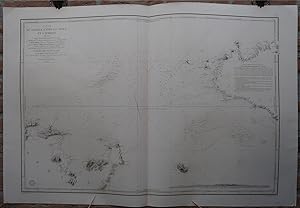
Antique map-SEA CHART-SICILY-TUNESIA-PANTELLERIA-Depot de la Marine-1843
Erscheinungsdatum: 1843
Anbieter: Pictura Prints, Art & Books, Overasselt, Niederlande
Bewertung:
Engraving on hand laid paper. on paper. Size in cm: The overall size is ca. 99.3 x 66.4 cm. The image size is ca. 86.4 x 58.7 cm. Size in inch: The overall size is ca. 39.1 x 26.1 inch. The image size is ca. 34 x 23.1 inch.Antique map, titled: ''Carte du Passage entre la Sicilie et l''Afrique [â ¦].'' - A sea chart of the Mediterranean, showing the South of Sicily in the right edge of the map (Palermo at the far edge) and the coast of North Africa (Tunesia) in the lower left. Also includes the island Pantelleria. Shows depth soundings, location of sand banks and geographical features along the shore. Published by the Depot de la Marine, dated 1843. The text by J. Hacq.Artists and Engravers: Made by 'Jacobs' after 'Mr. Bonard ao.'. Depot des Cartes et Plans de la Marine (1720 - present), often called the Depot de Marine, was a French hydrographic mapping organization founded in 1720. Much like the U.S. Coast Survey, the British Admiralty, and the Spanish Deposito Hydrografico, the Depot was initiated as a storehouse and distribution center of existing nautical and marine charts. Eventually the Depot initiated its on mapping activities in an attempt to improve and expand upon existing material. Some of the well known hydrograhers / cartographers in the development of Depot were Jacques Nicholas Bellin and Riobert Bonne.Condition: Very good, given age. Original middle fold, as issued. Offsetting where the map was folded on itself. A few small creases and faint stains in the margins. General age-related toning and/or occasional minor defects from handling. Please study scan carefully.Keywords: ANTIQUE MAP-SEA CHART-SICILY-TUNESIA-PANTELLERIA-DEPOT DE LA MARINE(PCO) GK-195.
-

Battle of Augusta - Sicily - 1676 - Magnificent Sea Battle in a Rough Sea - an Original Engraving
Erscheinungsdatum: 1820
Anbieter: K Books Ltd ABA ILAB, York, YORKS, Vereinigtes Königreich
Verbandsmitglied: ABA ILAB PBFA
Bewertung:
Buch
No Binding. Zustand: Very Good. A fine engraving - printed in 1820. Mounted and ready to frame. A fine opportunity to purchase an attractive and decorative engraving of a naval view - Battle of Augusta - Sicily.
-

The Centre of the Central Sea: Malta. Sicily. an Ascent of Mount Etna by Officers of a Man-Of-War
Verlag: LIGHTNING SOURCE INC, 2016
ISBN 10: 1356753167ISBN 13: 9781356753161
Buch
Gebunden. Zustand: New.
-
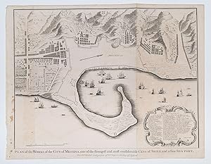
Plan of the Works of the City of Messina, one of the strongest and most considerable Cities of Sicily, and a fine Sea-Port.
Verlag: London-47, 1732
Anbieter: Robert Frew Ltd. ABA ILAB, London, Vereinigtes Königreich
Verbandsmitglied: ABA ILAB PBFA
Bewertung:
Karte
36 x 47.5 cm. Uncoloured. Double page plan. A few stains towards left edge. Some very light offsetting, otherwise good.
-
Plan of the Works of the City of Messina, one of the strongest and most considerable Cities of Sicily, and a fine Sea-port.
Erscheinungsdatum: 1750
Anbieter: Altea Antique Maps, London, Vereinigtes Königreich
Verbandsmitglied: ABA ILAB PBFA
Bewertung:
Karte
No Binding. Zustand: Good. London, Rapin & Tindall, c.1750. Coloured. 380 x 480mm. Engraved by Basire for Rapin's History of England, with an extensive key.
-
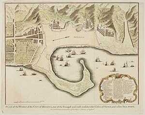
Plan of the Works of the city of Messina, one of the strongest and most confiderable Cities of Sicily, and a fine sea- port
Verlag: Artist: Rapin de Thoyras Paul ( - 1725 ) ; issued in: London ; ca: 1745; - Paul de Rapin de Thoyras ( 1661 ? 1725) sieur of Thoyras (and therefore styled Thoyras de Rapin) was a French historian writing under English patronage The son of Jacques de Rapin an avocat at Castres (Tarn) he was educated at the Protestant Academy of Saumur and in 1679 became an advocate but soon afterwards joined the army The revocation of the Edict of Nantes in 1685 and the death of his father led him to move to England; but unable to find work there he went on to the Netherlands where he enlisted in a company of French volunteers at Utrecht commanded by his cousin Daniel de Rapin He accompanied William III to England in 1688 and during the Williamite war in Irel, 1661
Anbieter: Antique Sommer& Sapunaru KG, München, Deutschland
Bewertung:

Technic: Copper print; colorit: original colored; condition: Perfect condition, size (in cm): 38 x 47 cm; - Map shows the port of Messina with offshore ships and city index.
-
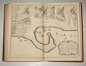
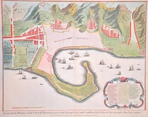
Original Copper Engraved View of the Plan of the Works of the City of Messina, one of the strongest and most considerable Cities of Sicily, and a fine Sea-Port
Verlag: London John & Paul Knapton 1752, 1752
Anbieter: PROCTOR / THE ANTIQUE MAP & BOOKSHOP, DORCHESTER, Vereinigtes Königreich
Verbandsmitglied: PBFA
Bewertung:
Unmounted. Original engraved double page plan. Size 19 x 16 inches. (49 x 40 cm) In very good condition. Centre Fold as issued. Two tiny dot holes on title lower margin. Uncoloured, Blank on verso. The decorative cartouche holds the key to the numbers on the map. Original engraved folding page map Bird's eye view style map. Antique black and white View of the City of Messina. MILITARY MAP. Showing battle lines and positions, contours and geographical features such as buildings, fortifications, fields and rivers. from Thomas Rapin's 'History of England'.
-

Strait of Sicily Area 1 - Balearic Basin-West Area 2 - Balearic Basin-North Area 3 - Ligurian Sea Area 4 - Balearic Basin-East Area 5 - Tyrrhenian Sea Area 6 - Alboran Sea Area 1- Aegean Sea Area 13.
Erscheinungsdatum: 1970
Anbieter: Libreria Piani, Monte San Pietro, BO, Italien
Bewertung:
Buch
Genova, Ist. Idr. Marina, 1970, otto carte ripiegate di cm. 64 x 86 circa cad.
-

A Journey across the Desert, from Ceylon to Marseilles: comprising sketches of Aden, the Red Sea, Lower Egypt, Malta, Sicily and Italy. By Major and Mrs. G. D. Griffith. [The illustrations taken from drawings made by Major G. D. Griffith.
Verlag: British Library, Historical Print Editions, 2011
ISBN 10: 1241336431ISBN 13: 9781241336431
Buch
Zustand: New.
-

Sketches of Foreign Travel and Life at Sea : Including a Cruise on Board a Man-Of-War, as Also a Visit So Spain, Portugal, the South of France, Italy, Sicily, Malta, the Ionian Islands, Continental Greece, Liberia, and Brazil; and a Treatise on
Verlag: HardPress Publishing, 2020
ISBN 10: 0371848032ISBN 13: 9780371848036
Buch
Zustand: Sehr gut. Zustand: Sehr gut - Gepflegter, sauberer Zustand. | Seiten: 454 | Sprache: Englisch.
-
The Little Sea Torch. or, True Guide for Coasting Pilots . .how to navigate along the coasts of England , Ireland , France , Spain , Portugal , Italy and Sicily ; the Isles of Malta , Corsica , Sardinia , and others in the Straits ; and of the coast of Barbary.
London, J. Debrett for the "author" (Serres), G. & W. Nicol, et al. (printed by T. Rickaby), 1801, in-folio, 44 x 28 cm, title + vi pp + 144 pp + (5)(index) + (1)(bl) + 20 hand coloured aquatint plates of the 137 approaches + 24 hand coloured plans on 12 sheets. (complete). Bound in contemporary leather, all edges gilt, marbled endpapers, binding with some traces of use and some wear at extremities, back cover scratched. Fine, stainless interior, with high quality hand coloured plates. Manuscript ex-libris on fly leaf (dated 1857, a member of the Mannock Strickland family). Abbey, Life in England 344; Cat. National Maritime Museum 218; Phillips & LeGear 2852. Only edition in English. This is an extensively revised edition of Bougard's Le Petit Flambeau de la Mer, a marine pilot guide to coastal navigation first published, in French, in 1684 . The list of subscribers contains the name of admiral Nelson duke of Bronte. It is almost certain that some copies of this atlas were on board of the English ships which participated in the sea battle at Trafalgar, which took place 4 years after the publication. On sheet 5 of the plans is represented the port of Cadiz, from which the French-Spanish fleet sailed to Trafalgar.
-

Sketches of Foreign Travel and Life at Sea, Vol. 1 of 2 : Including a Cruise on Board a Man-of-War, as Also a Visit to Spain, Portugal, the South of France, Italy, Sicily, Malta, the Ionian Islands, Continental Greece, Liberia, and Brazil, and a Treatise o
Verlag: Forgotten Books, 2016
ISBN 10: 1332900879ISBN 13: 9781332900879
Buch
Zustand: Wie neu. Zustand: Wie neu | Seiten: 436 | Sprache: Englisch.
-
The little sea torch: or, true guide for coasting pilots: by which they are clearly instructed how to navigate along the coasts of England, Ireland, France, Spain, Portugal, Italy, and Sicily; the isles of Malta, Corsica, Sardinia, and others in the straits; and of the coast of Barbary, from Cape Bon to Cape de Verd. Enriched with upwards of one hundred appearances of head-lands and light-houses. Together with plans of the principal harbours. Also a table of soundings [.].
Verlag: London, printed by T. Rickaby for J. Debrett and the author, 1801., 1801
Anbieter: Antiquariat INLIBRIS Gilhofer Nfg. GmbH, Vienna, A, Österreich
Verbandsmitglied: ILAB VDA VDAO
Bewertung:
Folio (285 x 447 mm). (2), II, 144, (6) pp. With 20 hand-coloured aquatint plates, each showing several coastal views, and 24 hand-coloured detailed plans on 12 plates, engraved by John Luffman. Contemporary half calf over marbled boards with giltstamped red spine label. Later endpapers. First English translation of Le Sieur Bougard's famous and oft-printed navigation manual, the "Petit flambeau de la mer", which contains "the minute description of the coasts of the countries and islands indicated by the title" (Phillips). Crucially, this edition boasts a new and original series of illustrations, "beautifully drawn and colored views of the principal headlands, harbors, lighthouses, ports, etc. mentioned in the text" (Phillips), drawn by the English painter John Thomas Serres (1759-1825), who was created Maritime Painter to King George III in 1793. In 1800 Serres became Marine Draughtsman to the Admiralty, and the sketches he made on his ensuing coastal voyages around Britain, France and Spain, and into the Mediterranean, were self-published in the present form, with the consent of the Admiralty (which purchased two copies). "The vast majority of the [.] 170 subscribers were naval officers. This may well be considered to be Serres's most important contribution to the arts of naval victory, both because it was a valuable aid to navigation and because it displays such consummate workmanship" (Tracy). The harbour charts are the work of John Luffman, who was active between 1776 and 1820 as an engraver, publisher, and goldsmith, and the "Naval Chronicle" published quite a few of Luffman's charts. - Slight wear to extremities. Occasional light spotting, neatly rebacked to style. - Phillips 2852. Goldsmiths'-Kress library of economic literature; v. 5, reel 22, no. 4. Tooley, Mapmakers I, 172. N. Tracy, Britannia's Palette: The Arts of Naval Victory (Montreal 2007), p. 232. Cf. Polak 1044; NHSM 69.
-
The New Sailing Directory For The Strait of Gibraltar and The Western Division of The Mediterranian Sea: Comprehending The Coasts of Spain, France and Italy, From Cape Trafalgar to Cape Spartivento; The Balearic Isles, Corsica, Sardinia, Sicily, and The Maltese Islands: With The African Coast. [Bound with] The New Sailing Directory for The Gulf of Venice And The Eastern or Levantine Division of The Mediterranean Sea; Together With The Sea of Marmara and The Euxine or Black Sea, Comprehending The Eastern Coast of Italy, The Illyrian Coast, The Coasts of Dalmatia and Greece, The Ionian and Grecian Isles, The Archipelago And Levant, &c.
Verlag: Printed for R. H. Laurie, London, 1840
Anbieter: McNaughtan's Bookshop, ABA PBFA ILAB, Edinburgh, Vereinigtes Königreich
Verbandsmitglied: ABA ILAB PBFA
Bewertung:
8vo, pp. xvi, xlv, [i], 208, xxvii, [i], 282. Contemporary half black calf, marbled boards, spine divided by double gilt rules between blind rolls, lettered in gilt direct, edges sprinkled red. Some spotting to first and last leaves. A bit rubbed and a touch worn. Two navigation aids by hydrographer John Purdy (1773-1843), covering the whole of the Mediterranean between them. Purdy ?was respected as the foremost authority in private chart publishing, where he was exceptional for the care with which he acknowledged the many varied sources on which his work was based? (ODNB) and is the namesake of the Purdy Islands in the Bismark Sea. Both volumes are scarce, with The Strait of Gibraltar only showing digital copies on Library Hub and 2 copies on Worldcat, at California and Missouri, and The Gulf of Venice only at the National Maritime Museum, Greenwich.

![Bild des Verkäufers für The little sea torch: or, true guide for coasting pilots: by which they are clearly instructed how to navigate along the coasts of England, Ireland, France, Spain, Portugal, Italy, and Sicily; the isles of Malta, Corsica, Sardinia, and others in the straits; and of the coast of Barbary, from Cape Bon to Cape de Verd. Enriched with upwards of one hundred appearances of head-lands and light-houses. Together with plans of the principal harbours. Also a table of soundings [.]. zum Verkauf von Antiquariat INLIBRIS Gilhofer Nfg. GmbH](https://pictures.abebooks.com/inventory/md/md22744513348.jpg)
![Bild des Verkäufers für The New Sailing Directory For The Strait of Gibraltar and The Western Division of The Mediterranian Sea: Comprehending The Coasts of Spain, France and Italy, From Cape Trafalgar to Cape Spartivento; The Balearic Isles, Corsica, Sardinia, Sicily, and The Maltese Islands: With The African Coast. [Bound with] The New Sailing Directory for The Gulf of Venice And The Eastern or Levantine Division of The Mediterranean Sea; Together With The Sea of Marmara and The Euxine or Black Sea, Comprehending The Eastern Coast of Italy, The Illyrian Coast, The Coasts of Dalmatia and Greece, The Ionian and Grecian Isles, The Archipelago And Levant, &c. zum Verkauf von McNaughtan's Bookshop, ABA PBFA ILAB](https://pictures.abebooks.com/inventory/md/md31048527302.jpg)