Gesamtpreis (1 Artikel Artikel):
Versandziel:

israel map (149 Ergebnisse)
Direkt zu den wichtigsten Suchergebnissen
Produktart
- Alle Produktarten
- Bücher (58)
- Magazine & Zeitschriften
- Comics
- Noten
- Kunst, Grafik & Poster (16)
- Fotografien
- Karten (75)
-
Manuskripte &
Papierantiquitäten
Zustand
Einband
Weitere Eigenschaften
Gratisversand
Land des Verkäufers
Verkäuferbewertung
-

The Road Map to Nowhere : Israel/Palestine Since 2003
Verlag: Verso Books, 2006
ISBN 10: 1844670767ISBN 13: 9781844670765
Buch Erstausgabe
Zustand: Good. 1st Edition. Former library book; may include library markings. Used book that is in clean, average condition without any missing pages.
-

Map of Israel
Verlag: U.S. Government Printing Office
Anbieter: Wonder Book, Frederick, MD, USA
Bewertung:

Zustand: Very Good. Very Good condition. Fold-out map in envelope.
-
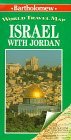
Israel with Jordan (Bartholomew World Travel Map S.)
Verlag: Hammond World Atlas Corp
ISBN 10: 0702830453ISBN 13: 9780702830457
Buch
Paperback. Zustand: Very Good. The book has been read, but is in excellent condition. Pages are intact and not marred by notes or highlighting. The spine remains undamaged.
Mehr Angebote von anderen Verkäufern bei ZVAB
Gebraucht ab EUR 2,95
-
Zustand: Fair. Acceptable condition. (Israel, Maps) A readable, intact copy that may have noticeable tears and wear to the spine. All pages of text are present, but they may include extensive notes and highlighting or be heavily stained. Includes reading copy only books.
-
Zustand: Good. Most items will be dispatched the same or the next working day.
-

israel & palästina - Zeitschrift für Dialog. Heft 4/2005 On the Road(map) Again?.
Verlag: Wochenschau, Schwalbach, 2005
Bro. Zustand: Sehr gut erhalten. israel & palästina - Zeitschrift für Dialog; 80 Seiten; Deutsch - Israelischer Arbeitskreis für Frieden im Nahen Osten e.V.diAk - Deutschland Israel Palästina - Zusammen denken e.V.
-
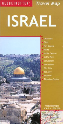
Globetrotter Israel (Globetrotter Travel Map)
Verlag: UNKNO, 2006
ISBN 10: 1845373316ISBN 13: 9781845373313
Buch
Befriedigend/Good: Durchschnittlich erhaltenes Buch bzw. Schutzumschlag mit Gebrauchsspuren, aber vollständigen Seiten. / Describes the average WORN book or dust jacket that has all the pages present.
-
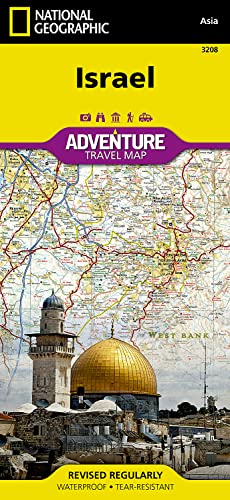
Israel Map (National Geographic Adventure Map, 3208)
Verlag: Natl Geographic Society Maps, 2019
ISBN 10: 156695617XISBN 13: 9781566956178
Buch
Paperback. Zustand: Very Good. The book has been read, but is in excellent condition. Pages are intact and not marred by notes or highlighting. The spine remains undamaged.
Mehr Angebote von anderen Verkäufern bei ZVAB
Neu ab EUR 18,91
Gebraucht ab EUR 13,70
Mehr entdecken Softcover
-

Befriedigend/Good: Durchschnittlich erhaltenes Buch bzw. Schutzumschlag mit Gebrauchsspuren, aber vollständigen Seiten. / Describes the average WORN book or dust jacket that has all the pages present.
-
Befriedigend/Good: Durchschnittlich erhaltenes Buch bzw. Schutzumschlag mit Gebrauchsspuren, aber vollständigen Seiten. / Describes the average WORN book or dust jacket that has all the pages present.
-
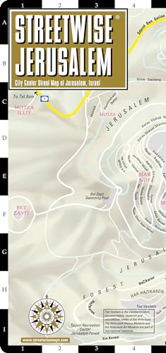
Streetwise Jerusalem Map - Laminated City Center Street Map of Jerusalem, Israel
Verlag: Michelin 2018-04-15, Boulogne-Billancourt, 2018
ISBN 10: 2067230123ISBN 13: 9782067230125
Buch
sheet map (folded). Zustand: New. Language: ENG.
-
Carta's Map of Israel
Verlag: Carta The Israel Map and Publishing Company Ltd.
Anbieter: Wonder Book, Frederick, MD, USA
Bewertung:
Zustand: Good. Good condition. (Israel, Maps) A copy that has been read but remains intact. May contain markings such as bookplates, stamps, limited notes and highlighting, or a few light stains.
-

Befriedigend/Good: Durchschnittlich erhaltenes Buch bzw. Schutzumschlag mit Gebrauchsspuren, aber vollständigen Seiten. / Describes the average WORN book or dust jacket that has all the pages present.
-
Couverture souple. Zustand: bon. RO80248892: Non daté. In-Plano. Broché. Bon état, Couv. convenable, Dos satisfaisant, Intérieur acceptable. Une carte dépliante en couleurs. . . . Classification Dewey : 912-Atlas, cartes et plans.
-
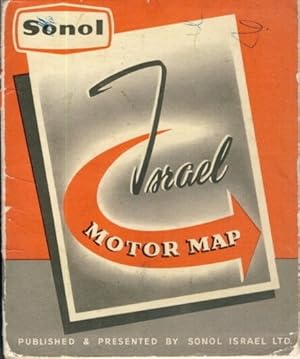
Zustand: guter bis sehr guter Zustand. guter bis sehr guter Zustand, geringe Gebrauchs- und Alterungsspuren: Umschlag abgenutzt und verschmutzt - Karte tadellos - Sonol offices - Sonol service & filling stations - Road signs - Map 1:500.000, revised by the Survey of Israel, December 1957 - Register Format: ca. 14 x 16,5 (aufgeklappt ca. 39 x 98) kartoniert / Papier Deutsch.
-
![Beispielbild für Jerusalem, Israel, Petra & Sinai [With Map] (DK Eyewitness Travel Guides) zum Verkauf von medimops](https://pictures.abebooks.com/isbn/9780756685713-de-300.jpg)
Jerusalem, Israel, Petra & Sinai [With Map] (DK Eyewitness Travel Guides)
Verlag: DK Eyewitness Travel, 2012
ISBN 10: 0756685710ISBN 13: 9780756685713
Buch
Gut/Very good: Buch bzw. Schutzumschlag mit wenigen Gebrauchsspuren an Einband, Schutzumschlag oder Seiten. / Describes a book or dust jacket that does show some signs of wear on either the binding, dust jacket or pages.
-
1 Kt., laminiert. Sprache: Deutsch Gewicht in Gramm: 500.
-

Pas de couverture. Zustand: bon. RO60118501: 1997. In-8. En feuillets. Bon état, Livré sans Couverture, Dos satisfaisant, Pliures. Carte dépliable en couleur d'env. 60/40 cm., recto-verso. . . . Classification Dewey : 912-Atlas, cartes et plans.
-
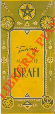
Touring map of Israel.
Erscheinungsdatum: 1950
Anbieter: Libreria Piani, Monte San Pietro, BO, Italien
Bewertung:
Buch
Jerusalem, (anni '50), cartina a col. ripiegata, scala 1:500.000 di cm 68 x 24 .
-
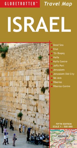
Israel (Globetrotter Travel Map)
Verlag: New Holland Publishers Ltd, 2009
ISBN 10: 1847736289ISBN 13: 9781847736284
Buch
map. Zustand: Used; Good. Dispatched, from the UK, within 48 hours of ordering. This book is in good condition but will show signs of previous ownership. Please expect some creasing to the spine and/or minor damage to the cover. Grubby book may have mild dirt or some staining, mostly on the edges of pages.
-
Map. 8vo; Large map, single sided, 600:485mm. Hebrew map of Erez Israel created for the Federation of American Zionists by Israel Belkind in the year of the Balfour Declaration, 1917. Belkind was born in Logoisk. In 1882, while studying at Kharkov University, he was among the students who founded the Bilu movement and went to Erez Israel at the head of its first group. He led the opposition against Baron Edmond de Rothschild's officials and, on being expelled by them from Rishon le-Zion, settled in Gederah. In 1889 Belkind opened a private Hebrew school in Jaffa. He was accepted as a teacher at the Alliance Israelite Universelle in Jerusalem in 1892, and there published several textbooks. In 1903 he foundedan agricultural training school at Shefeyah (near Zikhron Ya'akov) for orphans of the Kishinev pogroms whom he brought to Erez Israel. However, theschool was forced to close down in 1906 because of lack of funds. During World War I Belkind was in the U.S., where he published his memoirs inYiddish, Di Ershte Shrit fun Yishuv Erets Yisroel ("The First Steps of the Jewish Settlement of Palestine," 1918), and created this map. Apart fromnumerous articles and popular pamphlets, Belkind published a geography of Palestine, Erez Yisrael ba-Zeman ha-Zeh ("The Land of Israel Today," 1928). He died in Berlin, where he had gone for medical treatment. His remains were interred in Rishon le-Zion. Map has light age staining, bit of edgewear in the extreme margins, Very Good Condition. Not in Wajntraub.
-
![Beispielbild für Archaeological Survey of Israel: Map of Nahal Yattir (139) [Israel Antiquities Authority] zum Verkauf von Windows Booksellers](https://pictures.abebooks.com/isbn/9789654060042-de-300.jpg)
Archaeological Survey of Israel: Map of Nahal Yattir (139) [Israel Antiquities Authority]
Verlag: Archaeological Survey of Israel, 1991
ISBN 10: 9654060043ISBN 13: 9789654060042
Buch
Paperback. Bilingual text in Hebrew and English. Previous owner name and stamp on half title. Wrappers are edge worn and scuffed. Some curling at corners. Else good. 280 pages. 280 pp.
-
Paper; 27" x 40". In color. With index. Scale 1" = 4 1/2 miles. Based on U. N. Security Council Official Records. OCLC lists no copies worldwide. C over brown; few 1-2" tears at folds. Good condition. (PC-1).
-
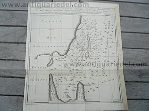
Hardcover. Zustand: very good. Coppermap, edited anno 1750, size of the leaf: 33x29 cm., some restorations on margin.
-

Hardcover. Zustand: Gut. Israel, map, anno 1720, Homann Coppermap, edited by Homann, Norimberg, anno 1720, size of the leaf: 50 x 60 cm., margins cracked, some cracs with a little loss in the map, foxed.
-
Survey of Israel, Ministry of Labour/ohne Ort Ed. Nov. 1964, zwei Teile: North and South (2 x 67,5x95,5 cm), Beigleitheftchen: List of Settlement, Localities and Antiquity Sites, zusammen in einer illustr. OKart.-Mappe, Mappe etwas bestoßen und angeschmutzt, bei Karten am oberen Rand mit kleiner Tesafilmverstärkungen zum Aufhängen, demmoch gut erhalten. 3601817 Sprache: Deutsch.
-
Paperback. Zustand: Very Good. The book has been read, but is in excellent condition. Pages are intact and not marred by notes or highlighting. The spine remains undamaged.
-

Sheet: Front: 'Palestine.' (Palestine, Israel map). Rear: text. Colour lithograph using rastering techniques. Description: This lithographic print originates from: 'Nouveau Larousse Illustre en sept volumes.', Directeur Claude Auge, Paris, published 1897-1904, with a supplement addedin 1907. The Nouveau Larousse illustre (New Larousse Illustrated) was an illustrated French language encyclopedia published by Larousse between 1897-1904, in 7 volumes and a supplement. It was essentially a scaled-down version of the 'Grand dictionnaire universel du XIXe siecle.' (Great universal dictionary of the 19th century) of Pierre Larousse, but updated and written in a more neutral, scientific style under the editorship of Claude Auge.Artists and Engravers: Pierre Larousse (1817-1875). Claude Auge (1854-1924). Plate by Vignerot Demoulin. Condition: Excellent. Some small stains in lower margin, not affecting image. General age-related toning and occasional light stains from handling. Please study image carefully. Storage location: A124-08 The overall size is ca. 9.3 x 12.2 inch. The image size is ca. 7.9 x 11.4 inch. The overall size is ca. 23.6 x 31 cm. The image size is ca. 20.1 x 29 cm.
-
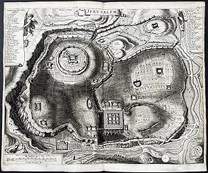
Jersualem" - Jerusalem Israel Palestine map plan
Verlag: Amsterdam c.1680., 1680
Anbieter: Antiquariat Steffen Völkel GmbH, Seubersdorf, Deutschland
Bewertung:
Kunst / Grafik / Poster
Rare copper engraving from circa 1680. -- size of sheet: ca.31 x39cm. -- in verygood condition. || Original Kupferstich von circa 1680. -- gut erhalten. Sprache: Niederländisch Gewicht in Gramm: 1550.
-
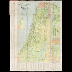
The Jewish Chronicle Map of Israel
Anbieter: Douglas Stewart Fine Books, Armadale, VIC, Australien
Bewertung:
Cover title : Map of Israel, including plans of Jaffa - Tel Aviv, Jerusalem, Haifa, the Middle East. London : Geographers' Map Co. for The Jewish Chronicle, November 1949. Map, printed in colour, 101 x 76 cms, folded and housed in lettered card wrappers (small tears to the corners, and at the point where the map is affixed to the wrappers, which have rubbed corners and a few stains), a very good example. Rare and early map of Israel published by the London-based Jewish weekly newspaper The Jewish Chronicle (founded in 1841, the oldest continuously published Jewish newspaper in the world), shortly after the Declaration of Independence of the Jewish State of Israel on 14 May 1948, and its admission to the United Nations on 11 May 1949, displaying Jewish Settlements and international borders based on the 1949 Armistice Agreements, 'subject to alteration and based on U. N. Security Council Official Records Ref. S/1302/Rev. 1. Dated 20th June, 1949' (from the key).