
Gesamtpreis (1 Artikel Artikel):
Versandziel:

borussiae regnum (45 Ergebnisse)
Direkt zu den wichtigsten Suchergebnissen
Produktart
- Alle Produktarten
- Bücher (9)
- Magazine & Zeitschriften
- Comics
- Noten
- Kunst, Grafik & Poster (10)
- Fotografien
- Karten (26)
-
Manuskripte &
Papierantiquitäten
Zustand
- Alle
- Neu
- Antiquarisch/Gebraucht
Einband
- alle Einbände
- Hardcover
- Softcover
Weitere Eigenschaften
- Erstausgabe
- Signiert (1)
- Schutzumschlag
- Angebotsfoto (41)
Land des Verkäufers
Verkäuferbewertung
-

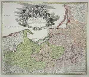
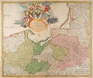
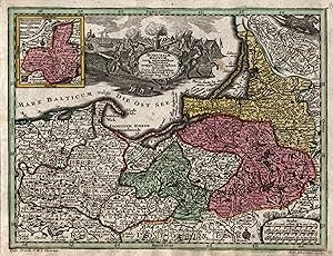
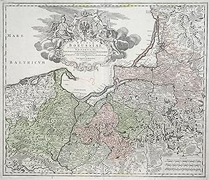
Borussiae Regnum.
Verlag: Augsburg, presso C.Lotter s.d. (ma 1744), 1744
Anbieter: Libreria Ex Libris ALAI-ILAB/LILA member, Roma, Italien
Bewertung:

Karte
Incisione originale su rame (cm. 27x20,5 piů margini). Coloritura coeva all'acquarello. Ottimo esemplare.
-
Altkolorierte Kupferstichkarte. Prachtvolle, barocke Kartusche mit dem Porträt von Friedrich III., späteren König Friedrich I. Ostpreussen mit Danzig, Königsberg bis zum südwestlichen Litauen. Mittelfalz teilweise gering angeplatzt, meist nur im Rand leicht fleckig. Sprache: Deutsch Gewicht in Gramm: 3000 Blattgröße: ca. 53 x 61 cm, Ansicht: ca. 47 x 57 cm.
-
Altkolorierte Kupferstich Landkarte v. Matth. Seutter, um 1730, 50 x 58 cm Große dekorative Kartusche. Gleichmäßig kräftiges Flächenkolorit. Schöner, kräftiger Druck. JPEG-Bilder auf Anfrage möglich. - Borussiae Regnum". Period coloured copperplate engraved map by Matthaus Seutter, ca. 1730 (50 x 58 cm / 19.6 x 22.8 in.) Large decorative cartouche. Evenly rich full period colouring. Nice rich print.
-
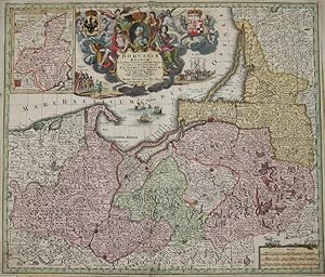
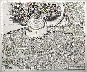
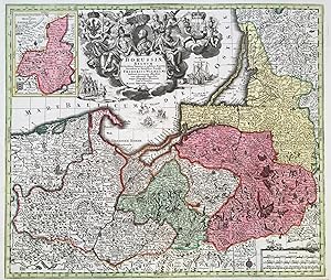
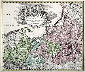
Regnum Borussiae". Altkolorierte Kupferstichkarte.
Verlag: Nürnberg, Hohmann, um 1730., 1730
Anbieter: Matthaeus Truppe Antiquariat, Graz, Österreich
Bewertung:
Karte
Grenz- und flächenkolorierte historische Landkarte von Ostpreußen mit Danzig, Königsberg bis zum Ende des kurischen Haffs im südwestlichen Litauen. Große dekorative Kartusche mit figuralem Schmuck. - Johann Baptist Homann veröffentlichte als erster deutscher Kupferstecher Karten und Atlanten in großer Zahl. Er stand mit zahlreichen Gelehrten in engem Kontakt um seine Karten, die zu den genauesten ihrer Zeit gehören, auf eine wissenschaftliche Grundlage zu stellen. Die Genauigkeit und die besonders dekorative Gestaltung seiner Karten machte Homanns Unternehmen zum führenden Kartenverlag des 18. Jahrhunderts in Deutschland. - Papierbedingt etw. gebräunt. *** *** Copyright: Matthaeus TRUPPE Buchhandlung & Antiquariat - Stubenberggasse 7 - A-8010 Graz - ++43 (0)316 - 829552 *** *** Sprache: Deutsch Gewicht in Gramm: 800 Ca. 49 cm x 58 cm (Platte), 54 cm x 61 cm (ganze Blatt).
-
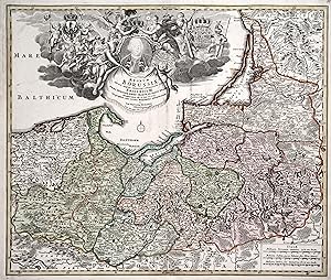
Borussiae Regnum? Friderici Wilhelmi.
Verlag: Artist: Seutter Matthias ( - 1757 ) Augsburg; issued in: Augsburg; Seutter Matthias ( 1678 - 1757 ) Augsburg; Matthias Seutter (1678- 1757) Augsburg was the son of a goldsmith in Augsburg In 1697 Seutter began his studies in Nuremberg and subsequently worked in the publishing house of Jeremias Wolff in Augsburg In 1710 he established his own publishing house and print shop The Seutter publishing house produced a great number of maps atlases and globes However very few original maps were printed there as Augsburg at that time had no university and no connection to the fields of mathematics or the natural sciences Seutter therefore copied the work of other cartographers making his own engravings based on their models Over 500 maps were produc, 1678
Anbieter: Antique Sommer& Sapunaru KG, München, Deutschland
Bewertung:

Technic: Copper print; colorit: original colored; condition: Very good; size (in cm): 49 x 57,5; Map shows total Prussia with the Baltic Sea coast, with splendoufully cartouche, ship representation and coat of arms. On inset map Neuchatel. History: Prussia: The name Prussia derives from the Old Prussians; in the 13th century, the Teutonic Knights?an organized Catholic medieval military order of German crusaders?conquered the lands inhabited by them. It was a historically prominent German state that originated in 1525 with a duchy centred on the region of Prussia on the southeast coast of the Baltic Sea. It was de facto dissolved by an emergency decree transferring powers of the Prussian government to German Chancellor Franz von Papen in 1932 and de jure by an Allied decree in 1947. For centuries, the House of Hohenzollern ruled Prussia, successfully expanding its size by way of an unusually well-organised and effective army. Prussia, with its capital in Königsberg and from 1701 in Berlin, decisively shaped the history of Germany. The Thirteen Years' War (1454?1466) began when the Prussian Confederation, a coalition of Hanseatic cities of western Prussia, rebelled against the Order and requested help from the Polish king, Casimir IV Jagiellon. The Teutonic Knights were forced to acknowledge the sovereignty of, and to pay tribute to Casimir IV in the Second Peace of Thorn (1466), losing western Prussia (Royal Prussia) to Poland in the process. Pursuant to the Second Peace of Thorn, two Prussian states were established. In 1701, Frederick William's son, Elector Frederick III, upgraded Prussia from a duchy to a kingdom and crowned himself King Frederick I. In the Crown Treaty of 16 November 1700, Leopold I, emperor of the Holy Roman Empire, allowed Frederick only to title himself "King in Prussia", not "King of Prussia". The state of Brandenburg-Prussia became commonly known as "Prussia", although most of its territory, in Brandenburg, Pomerania, and western Germany, lay outside Prussia proper. The Prussian state grew in splendour during the reign of Frederick I, who sponsored the arts at the expense of the treasury. During the reign of King Frederick William II (1786?1797), Prussia annexed additional Polish territory through further Partitions of Poland. His successor, Frederick William III (1797?1840), announced the union of the Prussian Lutheran and Reformed churches into one church.
-
Kein Einband. Zustand: Gut. Original Kupferstich von: Homann: Regnum Borrusiae. Um 1740. Blattgröße: ca. 62 x 53 cm. Etwas fleckig, leichte Gebrauchsspuren. Leichte Quetschfalten. Original engraving from: HomannPublished approx. 1740. Sheetsize: approx. 62 x 52 cm. Slight staining, some wrinkling in places.
-

OSTPREUSSEN. - Karte. "Regnum Borussiae . Friderici III".
Anbieter: Peter Bierl Buch- & Kunstantiquariat Inh.: Andrea Bierl, Eurasburg, Deutschland
Bewertung:
Kunst / Grafik / Poster
Altkol. Kupferstich von J.B. Homann, um 1720, 49 x 57 cm. Karte von Ostpreussen mit großer figürlicher Kartusche oben (mit Porträt Friedrich III.), rechts unten Meilenzeiger.
-
1 Karte plano 57 x 48 cm gutes Exemplar.
-
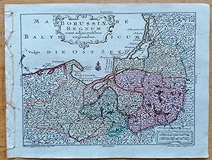
Lotter Original Map Prussia Poland - Borussiae Regnum
Verlag: Augsburg, Wagner für Lobeck, 1755
Karte
Kein Einband. Zustand: Gut. Original engraving from: Lotter/Lobeck: Atlas portatilis. Augsburg, 1755. Sheetsize: 14 x 10.5 cm. Condition: please see photo.
-
Regnum Borussiae. Flächenkolorierte Kupferstichkarte mit unkolorierter Kartusche.
Verlag: Nürnberg, Joh. Bapt. Homann, um 1740., 1740
Kunst / Grafik / Poster
49,0 x 58,0 cm. Ecke unten links mit leichtem Wasserrand, rechter weißer Rand etwas fleckig. [SW - Landkarte, Landkarten].
-
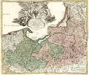
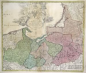
Borussiae regnum cum adjacentisbus Regionibus mappa Geographica.
Verlag: Artist: Seutter Matthias ( - 1757 ) Augsburg; issued in: Augsburg; Seutter Matthias ( 1678 - 1757 ) Augsburg; Matthias Seutter (1678- 1757) Augsburg was the son of a goldsmith in Augsburg In 1697 Seutter began his studies in Nuremberg and subsequently worked in the publishing house of Jeremias Wolff in Augsburg In 1710 he established his own publishing house and print shop The Seutter publishing house produced a great number of maps atlases and globes However very few original maps were printed there as Augsburg at that time had no university and no connection to the fields of mathematics or the natural sciences Seutter therefore copied the work of other cartographers making his own engravings based on their models Over 500 maps were produc, 1678
Anbieter: Antique Sommer& Sapunaru KG, München, Deutschland
Bewertung:
Technic: Copper print; colorit: original colored; condition: Very good; size (in cm): 19 x 25,5; Map shows total Prussia, ob inset map Neufchatel.
-
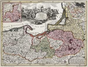
Regnum Borussiae gloriosis auspicijis Serenissimi e Potentissimi?
Verlag: Artist: Homann Johann Babtiste ( - 1724 ) Nuremberg; issued in: Nuremberg; Homann Johann Babtiste ( 1664 - 1724 ) Nuremberg; Johann Babtiste Homann (1664-1724) Nuremberg was born in Oberkammlach the Electorate of Bavaria Although educated at a Jesuit school and preparing for an ecclesiastical career he eventually converted to Protestantism and from 1687 worked as a civil law notary in Nuremberg He soon turned to engraving and cartography; in 1702 he founded his own publishing house Homann acquired renown as a leading German cartographer and in 1715 was appointed Imperial Geographer by Emperor Charles VI Giving such privileges to individuals was an added right that the Holy Roman Emperor enjoyed In the same year he was also named a member of, 1664
Anbieter: Antique Sommer& Sapunaru KG, München, Deutschland
Bewertung:
Technic: Copper print; colorit: original colored; condition: Minor restorations; size (in cm): 48 x 57; Gorgeous map of Prussia with the Baltic regoin. History: Prussia: The name Prussia derives from the Old Prussians; in the 13th century, the Teutonic Knights?an organized Catholic medieval military order of German crusaders?conquered the lands inhabited by them. It was a historically prominent German state that originated in 1525 with a duchy centred on the region of Prussia on the southeast coast of the Baltic Sea. It was de facto dissolved by an emergency decree transferring powers of the Prussian government to German Chancellor Franz von Papen in 1932 and de jure by an Allied decree in 1947. For centuries, the House of Hohenzollern ruled Prussia, successfully expanding its size by way of an unusually well-organised and effective army. Prussia, with its capital in Königsberg and from 1701 in Berlin, decisively shaped the history of Germany. The Thirteen Years' War (1454?1466) began when the Prussian Confederation, a coalition of Hanseatic cities of western Prussia, rebelled against the Order and requested help from the Polish king, Casimir IV Jagiellon. The Teutonic Knights were forced to acknowledge the sovereignty of, and to pay tribute to Casimir IV in the Second Peace of Thorn (1466), losing western Prussia (Royal Prussia) to Poland in the process. Pursuant to the Second Peace of Thorn, two Prussian states were established. In 1701, Frederick William's son, Elector Frederick III, upgraded Prussia from a duchy to a kingdom and crowned himself King Frederick I. In the Crown Treaty of 16 November 1700, Leopold I, emperor of the Holy Roman Empire, allowed Frederick only to title himself "King in Prussia", not "King of Prussia". The state of Brandenburg-Prussia became commonly known as "Prussia", although most of its territory, in Brandenburg, Pomerania, and western Germany, lay outside Prussia proper. The Prussian state grew in splendour during the reign of Frederick I, who sponsored the arts at the expense of the treasury. During the reign of King Frederick William II (1786?1797), Prussia annexed additional Polish territory through further Partitions of Poland. His successor, Frederick William III (1797?1840), announced the union of the Prussian Lutheran and Reformed churches into one church.
-
OST- und WESTPREUSSEN. - Karte. "Regnum Borussiae . Friderici III".
Anbieter: Peter Bierl Buch- & Kunstantiquariat Inh.: Andrea Bierl, Eurasburg, Deutschland
Bewertung:
Kunst / Grafik / Poster
Altkol. Kupferstich von J.B. Homann, um 1720, 48 x 57 cm. Karte von Ostpreussen mit großer, kolorierter, figürlicher Kartusche oben (mit Porträt Friedrich III.), rechts unten Meilenzeiger. - Schönes altes Flächenkolorit.
-
Kupferstich- Karte, b. J. B. Homann, "Regnum Borussiae .".
Anbieter: Antiquariat Clemens Paulusch GmbH, Berlin, Deutschland
Bewertung:
Karte
mit Grenzkolorit, um 1715, 48,3 x 57,5 Jäger, Nr. 95. (Engel mit sichtbarer Brust, s. Jäger). - Dek. Karte mit übergroßer fig. u. herald. Kartusche mit einem Portrait Friedrich I. und kleiner Karte der preuss. Monarchie. Jäger:"Die erste Prussia-Karte mit eingetragenen Postrouten".
-

Kupferstich- Karte, b. J. B. Homann, "Regnum Borussiae .".
Anbieter: Antiquariat Clemens Paulusch GmbH, Berlin, Deutschland
Bewertung:
Karte
mit altem Flächenkolorit, um 1715, 48,3 x 57,5 Jäger, Nr. 95. ( Engel mit sichtbarer Brust, s. Jäger ). - Dek. Karte mit übergroßer fig. u. herald. Kartusche mit einem Portrait Friedrich I. und kleiner Karte der preuss. Monarchie. Jäger:"Die erste Prussia-Karte mit eingetragenen Postrouten".
-
Kupferstich- Karte, b. J. B. Homann, "Regnum Borussiae .".
Anbieter: Antiquariat Clemens Paulusch GmbH, Berlin, Deutschland
Bewertung:
Karte
mit altem Flächenkolorit, um 1730, 48,3 x 57,5 Jäger, Nr. 97. Dek. Karte mit übergroßer fig. u. herald. Kartusche mit einem Portrait Friedrich Wilhelm I. und kleiner Karte der preuss. Monarchie. Jäger:"Die erste Prussia-Karte mit eingetragenen Postrouten".
-
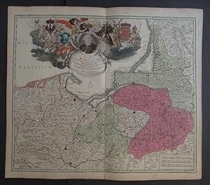
Borussić Regnum.
Erscheinungsdatum: 1730
Anbieter: Altea Antique Maps, London, Vereinigtes Königreich
Verbandsmitglied: ABA ILAB PBFA
Bewertung:
Karte
Augsburg, c.1730, Original colour, 495 x 580mm Bottom centerfold repaired, otherwise a very fine example. Showing the Baltic coast of Poland, Kaliningrad and part of Lithuania, from the 'Atlantis Geographicus Maior' engraved by Tobias Conrad Lotter, and marking topography and settlements, with an inset of Neufchatel. The elaborate title cartouche which depicts personifications of Justice, War and Prudence, is surmounted by a portrait of Friedrich Wilhelm I of Prussia (1688-1740) who resettled East Prussia after a devastating plague in 1709. He was also the sovereign prince of the Principality of Neuchâtel in Western Switzerland, hence its inclusion here as an inset. Also in the title cartouche can be seen a depiction of Friedrich Wilhelm's famous regiment of taller than average soldiers, known as the 'Potsdam Giants', entry to which required a minimum height of 6ft 2.
-
Kupferstich- Karte, v. Silbereisen b. M. Seutter, "Borussiae Regnum .".
Anbieter: Antiquariat Clemens Paulusch GmbH, Berlin, Deutschland
Bewertung:
Karte
mit altem Flächenkolorit, um 1745, 19,7 x 25,5 Jaeger, Nr. 117. Oben mittig die Titelkartusche, rechts unten Meilenanzeiger. Mit zwei kleinen Nebenkarten. Links oben eine kleine Karte vom Fürstentum Neuchatel, rechts oben eine Karte von Schlesien.
-

Kupferstich- Karte, b. Tob. Con. Lotter, "Borussiae Regnum complectens .".
Anbieter: Antiquariat Clemens Paulusch GmbH, Berlin, Deutschland
Bewertung:
Karte
mit altem Flächenkolorit, um 1770, 49,2 x 57 Jäger, Nr. 159. - Dek. Karte mit prachtvoller Kartusche im Rokokostil ( mit Portrait Friedrich des Großen ). 2. Zustand der Prussiakarte von Lotter ( ohne Datierung ), die dieser - nach der Teilung des seutterischen Verlages ( 1757 ) - neu anfertigte.
-
Kupferstich- Karte, b. Tob. Con. Lotter, "Borussiae Regnum complectens .".
Anbieter: Antiquariat Clemens Paulusch GmbH, Berlin, Deutschland
Bewertung:
Karte
mit altem Flächenkolorit, dat. 1759, 49,2 x 57 Jäger, Nr. 158 und Abb. 223 (der Kartusche) und S.117 (der Karte). Ritter, die Welt aus Augsburg, S. 49. - Dek. Karte mit prachtvoller Kartusche im Rokokostil (mit Portrait Friedrich des Großen). 1. Zustand der Prussiakarte von Lotter (Datierung 1759), die dieser - nach der Teilung des Seutterischen Verlages (1757) - neu anfertigte.
-
Kupferstich- Karte, b. J. B. Homann ( Homann Erben ), "Regnum Borussiae .".
Anbieter: Antiquariat Clemens Paulusch GmbH, Berlin, Deutschland
Bewertung:
Karte
mit altem Flächenkolorit, um 1735, 48,4 x 57,5 Jäger, Nr. 99. Mit allen Merkmalen. - Große Kartusche m. fig. Schmuck und Adler auf Wappenschild.
-
Kupferstich- Karte, b. J. B. Homann ( Homann Erben ), "Regnum Borussiae .".
Anbieter: Antiquariat Clemens Paulusch GmbH, Berlin, Deutschland
Bewertung:
Karte
mit altem Flächenkolorit, nach 1749, 48,4 x 57,5 Jäger, Nr. 100. Mit allen Merkmalen. - Große Kartusche m. fig. Schmuck und Adler auf Wappenschild. Privileg getilgt.
-
Kupferstich- Karte, b. J. B. Homann (Homann Erben), "Regnum Borussiae .".
Anbieter: Antiquariat Clemens Paulusch GmbH, Berlin, Deutschland
Bewertung:
Karte
mit altem Flächenkolorit, nach 1753, 47,8 x 56,8 Jäger, Nr. 101. - Mit großer Kartusche, m. Adler auf Wappenschild. - Am Lager auch ein 2. Exemplar, leider mäßig im Druck und Buntstiftbekritzelung. ( Preis 150.- Euro ).
-
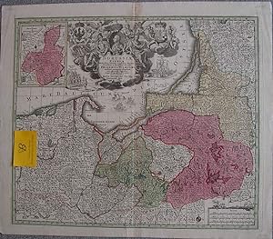
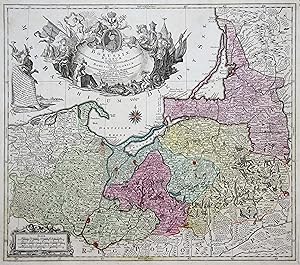
Borussiae Regnum sub fortissimo Tutamine et justissimo Regimine Friderici Wilhelmi.
Verlag: Augsburg ca. ,, 1725
Anbieter: Antiquariat Ruthild Jäger, Lueneburg, Deutschland
Bewertung:

Kunst / Grafik / Poster Signiert
Altkolor. Kupferstich 56 x 48 cm. Sehr gut erhalten. * Jäger, Prussia-Karten Nr. 111. Dekorative Karte von Ost- und Westpreußen mit großer allegorischer Kartusche (darin Medaillonportrait des Königs Friedrich Wilhelm I.). Die Karte zeigt Ost- und Westpreußen sowie als kleine Nebenkarte das Fürstentum Neuchâtel (das damals und noch bis weit in das 19. Jahrhundert hinein zu Preußen gehörte!). Vorliegene Karte stellt den frühesten Plattenzustand dar: Seutter signiert als "Chalcographus", noch nicht als kaiserlicher Geograph. Schönes Exemplar in kräftigen Farben.
-

Regnum Borussiae Gloriosis auspiciis Serenissimi et Potentissimi Princi Friderici III .
Anbieter: Kunstantiquariat Beisler, Weilheim i. Ob., Deutschland
Bewertung:
Altkolorierte Kupferstich- Landkarte v. Joh. Bapt. Homann b. Nürnberg, 1701, 50 x 59 cm. Im oberen Drittel prachtvolle Kartusche mit Herrschafts- und Kriegsmotiven.- Kräftiger originaler Druck, im Bug etwas schwächer. Im unteren Rand Wurmloch. Am oberen Rand leichte Einrisse.- Gut erhalten. Dekoratives Blatt. JPEG-Bilder auf Anfrage möglich. East Prussia. "Regnum Borussiae Gloriosis auspiciis .". Period coloured copperplate engraved map by J. B. Homann, Nuremberg ca. 1701. 50 x 59 cm. JPEG pictures upon request. In the upper third beautiful cartouche with motifs of rule and war.- Clear and rich print, a bit weaker in the fold. Wormhole in the down rim. Small tears in the upper rim. Otherwise in a good condition. Decorative !.
-
Kupferstich- Karte, b. J. B. Homann (Homann Erben), "Regnum Borussiae .".
Anbieter: Antiquariat Clemens Paulusch GmbH, Berlin, Deutschland
Bewertung:
Karte
mit altem Flächenkolorit, nach 1753, 47,8 x 56,8 Jäger, Nr. 101. - Mit großer Kartusche, m. Adler auf Wappenschild. - Sehr schönes Exemplar.
-
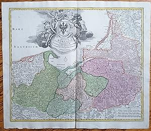
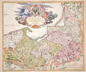
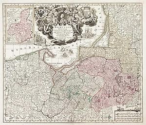
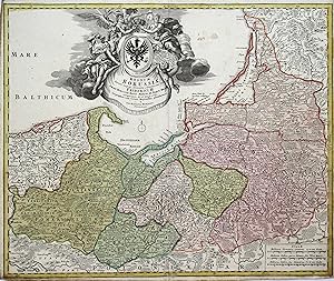
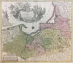
Regnum Borussiae Gloriosis auspiciis Serenissimi e Potentissimi Priv. Friderici III. - [Ostpreußen]. -
Verlag: Nürnberg: Homann, [um ]., 1720
Kunst / Grafik / Poster
Altkolorierte Kupferstichkarte von J.B. Homann, 48,5 x 57 cm. Blattgröße 52 x 63,5 cm. Im oberen Bildbereich ausladende, dekorative Kartusche mit Engeln, heraldischen Elementen. einem Portrait und einer kleinen Landkarte. Unter dem Titel Druckerprivileg. In der unteren rechten Bildecke eine Tafel mit Entfernungsmaßstäben. - Das Altkolorit von Karte und Kartusche leuchtend und sorgfältig. Einige Randeinrisse alt hinterklebt, am oberen Blattrand minimal wasserrandig und ein unschöner Klebestreifen außerhalb des Plattenrandes. Trotz der beschriebenen Mängel ordentliches Exemplar.
-
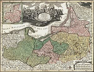
Borussiae Regnum Circulos Sambiensem, Natangiensem et Hockerlandiae Nec non Borussia Polonica
Verlag: Augsburg, 1759
Anbieter: Argosy Book Store, ABAA, ILAB, New York, NY, USA
Bewertung:
unbound. Map. Engraving with hand coloring. 20 1/2" x 25 3/4". Beautifully designed map of Northern Poland. Spans from Pomerania and Palatinatus to Lithuania and Belarus, and shows the coast on the Baltic Sea. Includes cities and towns, mountains, forests, bodies of water, and other topographical features. Notes each voivodeship. Two lavish title cartouches with float in the Baltic centered on a portrait of Frederick the Great. Tobias Conrad Lotter was a German mapmaker based in Augsburg. His work dates to the revival of mapmaking in 18th century Germany that was spurred in large part by the work of Matthäus Seutter. Lotter, who married Seutter's daughter, worked on behalf of the Seutter firm as a master engraver and took over half of the printing house upon Seutter's death. His individual work, combined with his republication of Seutter's maps under his own imprint, allowed Lotter to match, if not surpass, his predecessor's reputation as one of the most prominent German cartographers of the period.
-
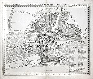
Stadtplan, "Regnum Borussiae Episcopatus Warmiensis Palatinatus Mariaburgensis" ( Kopftitel) und "Plan der Stadt Koenigsberg".
Anbieter: Antiquariat Clemens Paulusch GmbH, Berlin, Deutschland
Bewertung:
Kunst / Grafik / Poster
Kupferstich aus Berliner Akademie, um 1765, 44 x 54,5 Jäger/Schreiner, Das alte Königsberg, Nr. 21. Detailreicher Plan der Stadt Königsberg, erschien als erstes Blatt zur großen Karte Ostpreussens nach Suchodoletz (siehe Jäger, Prussia - Karten, Nr. 183). Die Zeichnung für diese Karte wurde laut Jäger schon 1732 angefertigt, daher zeigt der Plan den Bauzustand Königsbergs wohl in der ersten Hälfte des 18. Jahrhunderts. Unten rechts Erklärungen von A-W; a-x und 1 - 13. Bis auf eine Mittelfalz ausgezeichnetes, breitrandiges Exemplar mit dem üblichen Stempel der Berliner Akademie.
-
Kupferstich- Karte, v. Silbereisen n. M. Seutter b. T.C. Lotter "Borussiae Regnum .".
Anbieter: Antiquariat Clemens Paulusch GmbH, Berlin, Deutschland
Bewertung:
Karte
mit altem Flächenkolorit, nach 1757, 19,7 x 25,5 Jaeger, Nr. 118. Oben mittig die Titelkartusche, rechts unten Meilenanzeiger. Mit zwei kleinen Nebenkarten. Links oben eine kleine Karte vom Fürstentum Neuchatel, rechts oben eine Karte von Schlesien. Bis an die Einfassungslinie beschnitten und montiert.

![Bild des Verkäufers für Regnum Borussiae Gloriosis auspiciis Serenissimi e Potentissimi Priv. Friderici III. - [Ostpreußen]. - zum Verkauf von Antiquariat Tautenhahn](https://pictures.abebooks.com/inventory/md/md30775718032.jpg)