Gesamtpreis (1 Artikel Artikel):
Versandziel:

account geographical astronomical expedition von sauer martin (11 Ergebnisse)
Produktart
- Alle Product Types
- Bücher (11)
- Magazine & Zeitschriften
- Comics
- Noten
- Kunst, Grafik & Poster
- Fotografien
- Karten
- Manuskripte & Papierantiquitäten
Zustand
Einband
Weitere Eigenschaften
- Erstausgabe (2)
- Signiert
- Schutzumschlag
- Angebotsfoto (7)
Gratisversand
- Versand nach USA gratis
Land des Verkäufers
Verkäuferbewertung
-

An account of a geographical and astronomical expedition to the northern parts of Russia.
Anbieter: Antiquariaat A. Kok & Zn. B.V., Amsterdam, Niederlande
Bewertung:

London, 1802 [Reprint, Richmond, 1972]. 332, [58] pp. B./w. ills. 1 fold. map. Hardcover.
-
An Account of a Geographical and Astronomical Expedition to the`
Erscheinungsdatum: 1785
Anbieter: Anthony C. Hall, Bookseller ABA ILAB, Isleworth, MIDDX, Vereinigtes Königreich
Verbandsmitglied: ABA ILAB PBFA
Bewertung:

Hardback. Northern Parts of Russia, for Ascertaining the Degrees of Latitude and Longitude of the Mouth of the River Kovima; of the Whole Coast of the Tshutski, to East Cape; and of the Islands in the Eastern Ocean, stretching to the American Coast. Performed, by Command of Her Imperial Majesty Catherine The Second, Empress of All the Russias, by Commodore Joseph Billings, In the Years 1785, &c. to 1794. The Whole Narrated from the Original Papers, by Martin Sauer, Secretary to the Expedition. 416pp, frontis., 14 plates & fldg. map (1802) reprinted Richmond Publishing, Richmond, Surrey 1972. Very good.
-
An Account of a Geographical and Astronomical Expedition to the Northern Parts of Russia : For Ascertaining the Degrees of Latitude and Longitude of the Mouth of the River Kovima, of the Whole Coast of the Tshutski, to East Cape, and of the Islands in the
Verlag: Forgotten Books, 2017
ISBN 10: 0282567372ISBN 13: 9780282567378
Buch
Zustand: Sehr gut. Zustand: Sehr gut - Gepflegter, sauberer Zustand. | Seiten: 454.
-

An Account of a Geographical and Astronomical Expedition to the Northern Parts of Russia : For Ascertaining the Degrees of Latitude and Longitude of the Mouth of the River Kovima; Of the Whole Coast of the Tshutski, to East Cape; And of the Islands in the
Verlag: Forgotten Books, 2016
ISBN 10: 1333105134ISBN 13: 9781333105136
Buch
Zustand: Sehr gut. Zustand: Sehr gut - Gepflegter, sauberer Zustand. | Seiten: 448 | Sprache: Englisch.
-
An Account of a Geographical and Astronomical Expedition to the Northern Parts of Russia: For Ascertaining the Degrees of Latitude and Longitude of t
Verlag: BIBLIOLIFE, 2012
ISBN 10: 1275625312ISBN 13: 9781275625310
Buch
Zustand: New.
-
An Account of a geographical and astronomical expedition to the northern parts of Russia, performed by . J. Billings in the year 1785 . to 1794. The whole narrated from the original papers, by M. Sauer.
Verlag: British Library, Historical Print Editions, 2011
ISBN 10: 1241495610ISBN 13: 9781241495619
Buch
Zustand: New.
-
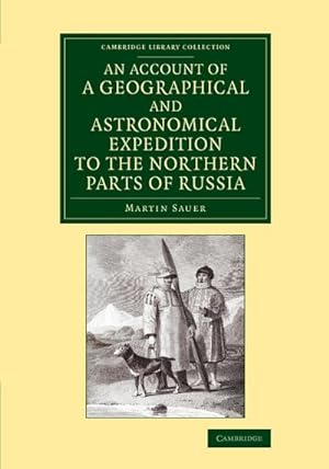
An Account of a Geographical and Astronomical Expedition to the Northern Parts of Russia
Verlag: Cambridge University Press, 2013
ISBN 10: 1108066658ISBN 13: 9781108066655
Buch
Taschenbuch. Zustand: Neu. Druck auf Anfrage Neuware - Printed after ordering - The first-hand 1802 account of the 1785-94 Russian expedition to chart the east Siberian coastline and undertake scientific activities.
-
An Account of a Geographical and Astronomical Expedition to the Northern Parts of Russia for ascertaining the degrees of latitude and longitude of the mouth of the River Kovima; of the whole coast of the Tshutski, to East Cape; and of The Islands in the Eastern Ocean, stretching to the American Coast. Performed, by Command of Her Imperial Majesty Catherine The Second, empress of all the Russians, By Commodore Joseph Billings, in the Years 1785, &c. to 1794. The whole narrated from the original papers by Martin Sauer
Verlag: London. Printed by A. Strahan, for T. Cadell. 1802, 1802
Anbieter: J. Patrick McGahern Books Inc. (ABAC), Ottawa, ON, Kanada
Verbandsmitglied: ABAC ILAB IOBA
Bewertung:
Erstausgabe
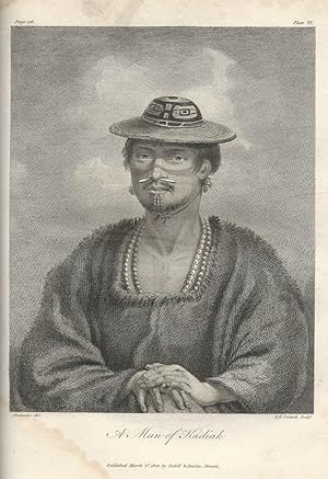
Hardcover. 1st Edition. 4to. 26.7cm, the First Edition, xxvi,[2],332,58p., (appendix: vocabularies), with 14 engraved plates, large engraved folding map, contemporary boards, rebacked in calf, light damp stain through the bottom spine corner mainly on the plates, and the last 20 text pages. Lada-Mocarski 58. Sabin 77152. Street VI: 3499. Howes S117. Cox. I-353. Hill I:268. Smith 8989. Wickersham 6134. Nerhood #112. - One of the most important Russian expeditions to Siberia and Alaska, with much material on the land and people, views of Kadiak, Aleutians, Kamchatka, etc. Captain Joseph Billings, who had sailed with James Cook on Cook's last voyage, became an officer in the Russian navy and was given command of this expedition by the Empress. He had, as his secretary, Martin Sauer, who was responsible for this, the fullest account of this important expedition. Visits were made to Kodiack, Montague Island, and Prince William Sound. Eventually a scarcity of provisions forced the return of the expedition to the mainland. The map, A Chart of the Strait between Asia and America, is by Arrowsmith. "Englishman serving in Catherine's navies sails and rides horseback along the north Russian coast, 1785-94. He provides a valuable description of the land and the natives by word and sketch". (Nerhood).
-
An Account of a Geographical and Astronomical Expedition to the Northern Parts of Russia, for ascertaining the degrees of latitude and longitude of the mouth of the River Kovima; of the whole coast of the Tshutski, to East Cape; and of the islands i n the Eastern Ocean, stretching to the American Coast. Performed, By Command of Her Imperial Majesty Catherine the Second?
Anbieter: John Windle Antiquarian Bookseller, ABAA, San Francisco, CA, USA
Verbandsmitglied: ABAA ILAB IOBA
Bewertung:
London: A. Strahan, 1802. 4to, xxvi, (1, errata), 332, 58 (Appendix) pp. With a large folding map before the title page, and 14 engraved plates. Some foxing in one gathering, otherwise a clean crisp copy entirely uncut and partially unopened in antique-style boards, paper backstrip lettered in black. § First and only edition in English of the Englishman Sauer's full account of the Billings voyage, on which he travelled as secretary to the Captain, it is the classic description of the Aleutian Islands. This was the last of the major Russian surveys of the eastern coast of Siberia, and accomplished a great deal of geographical research. They visited Kodiak, Montague Island and Prince William Sound, and saw Mount St. Elias.Billings's naval career had started under Cook: he sailed as an able-bodied seaman on the Discovery, transferring on Cook's death to the Resolution. His voyage included a revisiting of Kamchatka where Captain Clerke, who had taken over the command of the third voyage after Cook's death, had been buried. One of the plates in this publication shows Clerke's grave.Sauer's is the "first account in English of the first major exploring expedition sent out by the Russians to the Frozen Ocean and the North Pacific after Bering's second expedition of 1741? The chart was made by Arrowsmith from Sauer's notes and Captain Billings's astronomical observations?" (Streeter). The large folding map is of Bering's Strait and the American and Asian coasts. The appendices include linguistic tables, one of which compares Kamchatkan, Aleutian and Kodiak dialects. Bibliography: Hill, 1528; Lada-Mocarski, 58.
-
An Account of a Geographical and Astronomical Expedition to the Northern Parts of Russia, for ascertaining the degrees of latitude and longitude of the mouth of the River Kovima; of the whole coast of the Tshutski, to East Cape; and of the islands in the Eastern Ocean, stretching to the American Coast. Performed, By Command of Her Imperial Majesty Catherine the Second.
Verlag: A. Strahan, London, 1802
Anbieter: Hordern House Rare Books, Surry Hills, NSW, Australien
Bewertung:

Zustand: Some foxing in one gathering. Quarto, xxvi, (1, errata), 332, 58 (Appendix) pp. With a large folding map before the title page, and 14 engraved plates. A clean crisp copy entirely uncut and partially unopened in antique-style boards, paper backstrip lettered in black. First and only edition in English of the Englishman Sauer's full account of the Billings voyage, on which he travelled as secretary to the Captain: the classic description of the Aleutian Islands. This was the last of the major Russian surveys of the eastern coast of Siberia, and accomplished a great deal of geographical research. They visited Kodiak, Montague Island and Prince William Sound, and saw Mount St. Elias. Billings's naval career had started under Cook: he sailed as an able-bodied seaman on the Discovery, transferring on Cook's death to the Resolution. His voyage included a revisiting of Kamchatka where Captain Clerke, who had taken over the command of the third voyage after Cook's death, had been buried. One of the plates in this publication shows Clerke's grave. Sauer's is the "first account in English of the first major exploring expedition sent out by the Russians to the Frozen Ocean and the North Pacific after Bering's second expedition of 1741. The chart was made by Arrowsmith from Sauer's notes and Captain Billings's astronomical observations." (Streeter). The large folding map is of Bering's Strait and the American and Asian coasts. The appendices include linguistic tables, one of which compares Kamchatkan, Aleutian and Kodiak dialects. .
-

An Account of a Geographical and Astronomical Expedition to the Northern Parts of Russia, for ascertaining the degrees of latitude and longitude of the mouth of the River Kovima; of the whole coast of the Tshutski, to East Cape; and of the islands in the Eastern Ocean, stretching to the American coast. Performed, by Command of Her Imperial Majesty Catherine the Second, Empress of All the Russias, by Commodore Joseph Billings, in the years 1785, &c. to 1794.
Erscheinungsdatum: 1802
Anbieter: Henry Sotheran Ltd, London, Vereinigtes Königreich
Verbandsmitglied: ABA ILAB PBFA
Bewertung:
Erstausgabe
London, Printed by A. Strahan ⦠For T. Cadell, Jun., and W. Davies, 1802. 4to. Modern calf-backed marbled boards, red morocco lettering-piece to spine; pp. xxvii, [2, errata], 332, 58 (Appendixes); one large folding map, 14 engraved plates; initially, the map and a few plates carefully cleaned, minimal spotting in places, a very good, entirely uncut and complete copy. First English edition. Sauer was secretary to the Billings' expedition, in which Sarychev also participated (his separate account was published in Russian in the same year). Billings sailed to the Behring Strait, touching land both on the Chukchi peninsular and in Alaska. Most importantly, the expedition explored the Aleutian islands. The present account, which complements Sarychev's, was compiled by Sauer from official reports. Chavanne 3988; Lada-Mocarski 58; Ricks' Alaska Bibliography p. 192.