Gesamtpreis (1 Artikel Artikel):
Versandziel:

james wyld (164 Ergebnisse)
Direkt zu den wichtigsten Suchergebnissen
Produktart
- Alle Produktarten
- Bücher (76)
- Magazine & Zeitschriften
- Comics
- Noten
- Kunst, Grafik & Poster (1)
- Fotografien
- Karten (83)
-
Manuskripte &
Papierantiquitäten (4)
Zustand
Einband
Weitere Eigenschaften
- Erstausgabe (6)
- Signiert (1)
- Schutzumschlag
- Angebotsfoto (140)
Land des Verkäufers
Verkäuferbewertung
-
A General Atlas, containing Maps illustrating some important periods in Ancient History and distinct Maps of the several Empires, Kingdoms and States in the World, From Original Drawings according to the latest Treaties by J. Wyld and Engraved by N. R. Hewitt
Verlag: Printed for John Thomson & Co. for Baldwin, Craddick & Joy, London, & John Cumming, Dublin ca. 1819-1825, Edinburgh, 1819
Anbieter: Attic Books (ABAC, ILAB), London, ON, Kanada
Bewertung:

Hardcover. Zustand: Very good. Second Edition. xxviii, Plates, 18 p. 38 cm. Frontispiece Mountains table, title page vignette, engraving p. viii, 8 in-text illustrations before plates (6 colour, 2 tables), 44 engraved hand-coloured plates, most with small vignettes. Bound in half leather with marbled paper boards. New endpapers. Signed by previous owner William Hossack (1829) on front and rear endpapers. Foxing. Repaired edges to plates 36 & 37. An attractive atlas engraved by N. R. Hewitt from maps drawn by James Wyld the Elder (1790-1836). One of the foremost geographers of his time, Wyld is credited with introducing lithography to map printing during the Peninsula Campaign in 1812. A prolific publisher, he is reputed to have died of overwork. The detailed maps in this atlas emphasize Europe but there are several maps showing the Americas and Australia. Most maps feature a vignette illustrating a feature of the region depicted. This second edition shows three new maps: Van Dieman's Land (Tasmania), New South Wales, and Ross, Parry, and Franklin's Discoveries in the Arctic Circle.
-
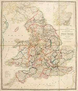
A Map of England, Wales, & Scotland describing all the Direct and principal Cross Roads in Great Britian, with the Distances measured between the Market Towns and From London.
Verlag: Published by James Wyld, Charing Cross East, Geographer To Her Majesty. London. A New General Atlas of Modern Geography Consisting of a Complete Collection of Maps of the Four Quarters of the Globe; Delineating their Physical Features and Coloured to show the Limits of their respective states. c1853, 1853
Anbieter: Peter Harrington. ABA/ ILAB., London, Vereinigtes Königreich
Verbandsmitglied: ABA ILAB PBFA
Bewertung:
A detailed map of England, Wales and southern Scotland, with inset of the north of Scotland. James Wyld was successor to William Faden, one of the luminaries of late eighteenth century publishing in England. Wyld maintained the high standard of graphic and factual excellence that had been established by his predecessor and his maps are among the finest published in the early nineteenth century. Copper engraving. Original outline colour. Good condition. Original fold lines as issued. On two sheets dissected and joined with linen. Several small tears along margins. 62 x 73 cm.
-
A Map of the Dutchy of Holstein, with the Territories of the Imperial Towns Hamburg and Lubeck
Verlag: London. 1853, 1853
Anbieter: Peter Harrington. ABA/ ILAB., London, Vereinigtes Königreich
Verbandsmitglied: ABA ILAB PBFA
Bewertung:
James Wyld maintained the high standard of graphic and factual excellence that had been established by his predecessors, and his maps are among the finest published in the early nineteenth century. This excellent map of the Dutchy of Holstein is no exception. Copper engraving. Original colour. Very good condition. Original fold line as issued. 58.5 x 66.5 cm.
-

A Map of the Kingdom of Poland, describing it's Ancient Limits with the Dismemberments Likewise Its Present Boundary As Settled by Act of Congress at Vienna.
Verlag: c.1838, London, 1838
Anbieter: Alexandre Antique Prints, Maps & Books, Toronto, ON, Kanada
Bewertung:

Karte
With a small inset map of Warsaw., Size : 544x610 (mm), 21.42x24.02 (Inches), Hand Colored Very Good; backed with acid free tissue paper for long term preservation.
-
A Map of the Province of Upper Canada, describing All The New Settlements, Townships, &c. With The Countries Adjacent, From Quebec To Lake Huron London, Published by Jas. Wyld, Geographer to Her Majesty, Charing Cross East 1838.
Verlag: [London: 1838]., 1838
Anbieter: D & E LAKE LTD. (ABAC/ILAB), Toronto, ON, Kanada
Bewertung:
No Binding. Zustand: Good. No Jacket. 22 1/2 x 34 inches (57 x 86.1 cm). original colour. backed on linen, as issued (narrow brown stain near horizontal fold & one section of linen stained). cloth slipcase (bit frayed) original printed label. First issued in 1800 by Smyth and subsequently revised by Wyld, this map of Upper Canada contains detailed information on the counties, districts, townships, transportation systems, place-names and northern Ontario ('Great Tract of Wilderness') &c. It also includes portions of Quebec, Michigan Territory, New York, Pennsylvania. The 1838 issue includes additional rivers, lakes, place-names, roads and a railway from London to Hamilton. Winearls, Mapping Upper Canada, 30.6b. Tooley, The Mapping of America, 82(e), p. 102.
-
A Map of the Province of Upper Canada, describing All the New Settlements, Townships, & c. With the Countries Adjacent from Quebec to Lake Huron.
Verlag: James Wyld c.1842, London, 1842
Anbieter: Alexandre Antique Prints, Maps & Books, Toronto, ON, Kanada
Bewertung:
Karte
Zustand: Very Good, An important and early map of Upper Canada with districts and counties shown. Map is compiled and corrected from the latest surveys in the Surveyor General's Office. It focuses on the Great Lakes, extending from Lake Superior and Lake Michigan in the West to Quebec City and New Hampshire to the East. , Size : 572x866 (mm), 22.52x34.09 (Inches), Original Hand Coloring.
-
A Map of the Province of Upper Canada, describing All the New Settlements, Townships, &c.
Verlag: London, 1838
Anbieter: Alexandre Antique Prints, Maps & Books, Toronto, ON, Kanada
Bewertung:
Karte
An important and early map of Upper Canada with districts and counties shown. Map is compiled and corrected from the latest surveys in the Surveyor General's Office. It focuses on the Great Lakes, extending from Lake Superior and Lake Michigan in the West to Quebec City and New Hampshire to the East. , Size : 568x870 (mm), 22.36x34.25 (Inches), Original Hand Coloring Very Good, with some skillful restorations, backed on acid free tissue paper for long term preservation.
-
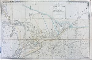
A Map of the Province of Upper Canada, describing all the New Settlements, Townships, &c, with the Countries Adjacent from Quebec to Lake Huron. Compiled from the Original Documents in the Surveyor General's Office
Verlag: London. Published by Jas. Wyld, Geographer to Her Majesty. 1838, 1838
Anbieter: J. Patrick McGahern Books Inc. (ABAC), Ottawa, ON, Kanada
Verbandsmitglied: ABAC ILAB IOBA
Bewertung:

Linen backed folding map, 57x 86cm, (22.5"x 34"), original colour, as issued, original printed label. very good to fine condition , rare. (cgc) First issued in 1800 by Smyth (see below). and subsequently revised by Wyld, this map of Upper Canada contains detailed information on the counties, districts, townships, transportation systems, place-names and northern Ontario ('Great Tract of Wilderness') &c. It also includes portions of Quebec, Michigan Territory, New York, Pennsylvania. The 1838 issue includes additional rivers, lakes, place-names, roads and a railway from London to Hamilton. Winearls, Mapping Upper Canada, 30.6b. Tooley, The Mapping of America, 82(e), p. 102.
-
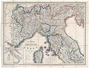
A Map of the Theatre of War In Italy.
Erscheinungsdatum: 1859
Anbieter: Altea Antique Maps, London, Vereinigtes Königreich
Verbandsmitglied: ABA ILAB PBFA
Bewertung:
Karte
London: James Wyld, c.1859. Original colour. Lithograph, sheet 650 x 850mm, dissected and laid on linen, original blind-decorated cloth boards with gilt title. Ownership inscription, 'Captain Acton, Dublin 20th May 1859', on front pastedown. A map of northern Italy, published to illustrate news reports about the Second War of Independence, 1859, with the Kingdom of Sardinia allied with the France of Napoleon III against the Austrian Empire. The war was short and inconclusive, as both France and Austria had reasons to call it off. Wyld published a similar but smaller map for the First War of Independence, 1848: this map is larger and has the names of the various states and railways overprinted.
-
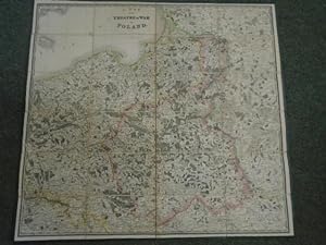
A Map of the Theatre of War in Poland
Verlag: Published by James Wyld, London, 1831
Karte
, 4 x 6 sectioned linnen backed paper engraved map, 1 inch to 20 miles, , the case is rubbed at the extremities, chipped at the corners and sunned, labels are lightly shaded, the map has light rubbing on the corners and edges but it is a fine quality map in very good+ condition , green cloth covered case with titled paper labels to the front and edge, green cloth cover edge to the back backed in cream linnen with green sugar paper end pannels , 66 x 72cm Hardback ISBN:
-
A New Map of England & Wales, Projected upon the Trigonometrical Operations made for the General Survey of the Kingdom.
Verlag: London, J.A. Wyld, (successor to McFaden) Geographer to Her Majesty, 1845, 1845
Anbieter: PROCTOR / THE ANTIQUE MAP & BOOKSHOP, DORCHESTER, Vereinigtes Königreich
Verbandsmitglied: PBFA
Bewertung:
Large folding canvas-backed map. 39 x 50.5 inches. Blue cloth edging. White and blue marbled paper outer covers. In very good condition. Overall darkened and tanned, with pinholes to corners and edges. Rubbing to edges of marbled paper covers. Some darkening and handling marks. Else a very good large map of England. Large B&W map with hand coloured boundary lines.
-

A New Map of Greece?
Verlag: Faden, London, 1828
Anbieter: Alexandre Antique Prints, Maps & Books, Toronto, ON, Kanada
Bewertung:
Karte
Zustand: Very good, folded. Size : 925x630 (mm), 36.375x24.75 (Inches), Original Hand Coloring.
-
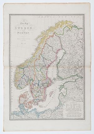
A New Map of Sweden and Norway.
Verlag: LondonJames Wyld. Geographer to the Queen 457 Strand Charing Cross East. c., 1870
Anbieter: Robert Frew Ltd. ABA ILAB, London, Vereinigtes Königreich
Verbandsmitglied: ABA ILAB PBFA
Bewertung:
Karte
Double page engraved map (70 x 50 cm overall sheet 84 x 58 cm.) with original outline colour. Trivial browning to outer margins not affecting map, generally very good.
-
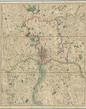
A New Map of the Country Twenty-Five Miles Round London.
Verlag: LondonPublished by James Wyld Geographer to the Queen and H.R.H. Prince Albert c., 1872
Anbieter: Robert Frew Ltd. ABA ILAB, London, Vereinigtes Königreich
Verbandsmitglied: ABA ILAB PBFA
Bewertung:
Karte
Very large engraved map of London and its environs (110 x 132 cm) with original hand-colouring, dissected into 32 sections and backed onto linen, folding into original brown cloth slipcase with title-label affixed to upper portion, publisher's advertisement to verso. Edged in green silk and with marbled paper covers to verso. Extends from Hertford in the north to Dorking in the south, and from Beaconsfield in the west to Chelmsford in the east. Engraved armorial bookplate to verso. Some faint offsetting, generally an excellent copy with particularly vibrant colour.
-
A New Map of the Country Twenty-five Miles Round London.
Verlag: James Wyld London c., 1872
Anbieter: Shapero Rare Books, London, Vereinigtes Königreich
Verbandsmitglied: ABA ILAB PBFA
Bewertung:
Karte
Hand coloured linen-backed map folding into dark blue slip case. Dimensions: 49 x 40.25 inches, scale one inch to 1 mile. Publisher's label on cover. Slip case worn along edges, but overall in very good condition. Extends from Hertford to Dorking and from Beaconsfield to Chelmsford. Shows the railway to Walthamstow (1870) extending south to Dalston (1872) but not north to Chingford (1873). Also shows the Great Northern Railway's Barnet branch (1872). Hyde D&H 188(3).
-
A New Map of the Province of Lower Canada, Describing all the Seigneuries, Townships, Grants of Land, &c. Compiled from Plans deposited in the Patent Office Quebec
Verlag: Wyld, James, London, 1840
Anbieter: Alexandre Antique Prints, Maps & Books, Toronto, ON, Kanada
Bewertung:
Karte
Zustand: Very Good, Size : 570x868 (mm), 22.44x34.17 (Inches), Original Hand Coloring.
-
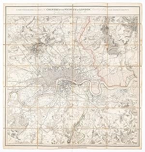
A New Topographical Map of the Country in the Vicinity of London, Describing all the New Improvements. Drawn from a Scale of two Inches to a Statute Mile.
Verlag: London July 3rd, 1828
Anbieter: Robert Frew Ltd. ABA ILAB, London, Vereinigtes Königreich
Verbandsmitglied: ABA ILAB PBFA
Bewertung:
Karte
(87 x 82 cm). Original folding map of London with some original outline colour. The map, printed on paper, dissected and mounted on to linen, shows extents from Edmonton in the north to Beckenham in the south and from Barnes in the west to Plumstead in the east. Blue marbled paper to folded end sections. Label of 'G. Cruchley, Map Seller & Publisher, 38, Ludgate Street, St. Pauls, London' to lower margin and advertisement for 'Works Published and Sold by G. Cruchley' to folded end-section. Some toning and wear. Folds and corners reinforced on verso. James Wyld (1812-1887) was "the most important mapmaker producing maps of London in the year of the Great Exhibition". Wyld was a highly successful publisher, MP for Bodmin, and an active figure in public life. He promoted the development of the British Library and campaigned for the Public Libraries and Museums Bill. Like his father, he was made Geographer to Queen Victoria and Prince Albert in 1836. He built his business on his ability to produce maps quickly in reaction to new discoveries and information: Punch remarked drily that if a country were discovered in the centre of the earth then Wyld would have a new map out "as soon as it is discovered, if not before".
-
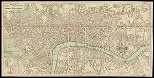
A Plan of London and Westminster with the Borough of Southwark. 1825.
Verlag: Published by James Wyld (Successor to W. Faden) Geographer to the King & to H.R.H. the Duke of York, 3 Charing Cross,, London,, 1825
Anbieter: Daniel Crouch Rare Books Ltd, London, Vereinigtes Königreich
Verbandsmitglied: ABA ILAB PBFA
Bewertung:

Wyld's plan of London and Westminster Engraved plan, original outline hand-colour, dissected and mounted on linen, evenly age-toned, housed within original brown marbled slipcase with publisher's label on front cover, remnants of twentieth century label on rear cover, reading "James Wyld (Successor to Mr. Faden) Geographer to his Majesty and to HRH the Duke of York. London, Charing Cross, opposite Northumberland House", rubbed. Wyld, the successor to William Faden, continued to issue his London maps, the present example covering the area from Regent's Park in the north west to Bethnal Green in the north east and Chelsea in the south west to Rotherhithe in the south east. To the lower left and lower right of the plan is a list of parishes without the City of London. The boundary of the City of London is marked out in red, the Borough of Southwark in green, the Liberties of Westminster in yellow, and Rules of the Bench and Fleet in orange.Faden had started issuing these popular and useful maps sometime before 1818; in August 1823 Wyld took over his Charing Cross map business.Scale: 5 inches to 1 statute mile. Howgego 272 (6).
-
A map of the Province of Upper Canada describing all the New Settlements, Townships, &c. With the countries adjacent, from Quebec to Lake Huron.
Verlag: Wyld, James c.1838, London, 1838
Anbieter: Alexandre Antique Prints, Maps & Books, Toronto, ON, Kanada
Bewertung:
Karte
This is an important and early map of Upper Canada with districts and counties shown. Map is compiled and corrected from the latest surveys in the Surveyor General\\\'s Office. It focuses on the Great Lakes, extending from Lake Superior and Lake Michigan in the West to Quebec City and New Hampshire to the East. Also, Upper New York state is depicted in detail. It is a finely engraved and nicely colored map., Size : 600x910 (mm), 23.625x35.75 (Inches), Original Hand Coloring Very Good, folding map dissected and laid down on original canvas.
-
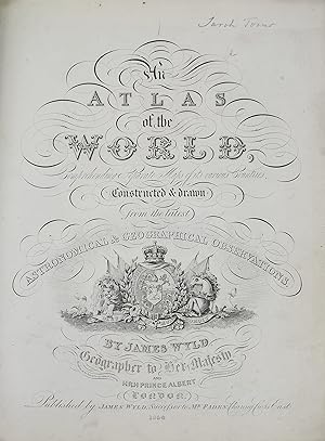
An Atlas of the World comprehending Separate Maps of its various Countries constructed and drawn from the latest Astromnical & Geographical Observations
Verlag: Published by James Wyld, Successor to Mr. Faden, Charing Cross East, London, 1858
Anbieter: James Cummins Bookseller, ABAA, New York, NY, USA
Bewertung:
With engraved title-page, letterpress contents leaf (on different stock) , double-page table "A Comparative Table of Itinerary Measures" , 3 tables, forty-six maps (double page of The Confederated Sates of Germany) in original wash colour. Large 4to (13 x 10-5/8 inches). Bound in half mottled polished brown calf and marbled boards. Very nice, maps crisp and well coloured With engraved title-page, letterpress contents leaf (on different stock) , double-page table "A Comparative Table of Itinerary Measures" , 3 tables, forty-six maps (double page of The Confederated Sates of Germany) in original wash colour. Large 4to (13 x 10-5/8 inches).
-
An Atlas of the World, comprehending separate maps of its various countries, constructed & drawn from the latest astronomical & geographical observations
Erscheinungsdatum: 1854
Anbieter: Maggs Bros. Ltd ABA, ILAB, PBFA, BA, London, Vereinigtes Königreich
Verbandsmitglied: ABA ILAB PBFA
Bewertung:
Quarto (330 x 254 mm); engraved title-page, letterpress contents, double-page table of scales, four tables, forty-six maps in original wash colour, South Africa trimmed with loss. Contemporary half dark red morocco over green cloth, gilt titling to spine and front board. Spine worn, boards rubbed and stained. London : James Wyld jr. Uncommon edition of Wyld?s quarto world atlas.
-
Autograph Letter Signed ('(Thomas Hyde Hills) | John Bell & Co') from Thomas Hyde Hills of John Bell & Co [later John Bell & Croyden], Oxford Street, to the M.P. James Wyld, regarding jury exemption for pharmaceutical chemists.
Verlag: 2 August ; 338 Oxford Street London, 1862
Anbieter: Richard M. Ford Ltd, London, Vereinigtes Königreich
Bewertung:
Manuskript / Papierantiquität
12mo, 2 pp. Fifteen lines. Text clear and complete. Thanking Wyld for his 'Support on Thursday in the House of Commons, agreeing with the Lords' Amendment for the exemption of Pharmaceutical Chemists serving on Juries'. He hopes that the exemption will prove 'a Stimulus to Pharmaceutical education and thereby be of great service and increased safety to the Public'. Hills was Mayor of Cambridge from 1894 to 1895.
-
Autograph Letter Signed ('Dudley Coutts Stuart | Vice-Presid[ent]') from Lord Dudley Stuart to James Wyld, Member of Parliament for Bodmin, as Vice-President of the Literary Association of the Friends of Poland, on behalf of a Polish refugee.
Verlag: 3 April ; on letterhead of the Literary Association of the Friends of Poland Sussex Chambers Duke Street St. James's, 1840
Anbieter: Richard M. Ford Ltd, London, Vereinigtes Königreich
Bewertung:
Manuskript / Papierantiquität
12mo, 3 pp. Text clear and complete. Worn and aged, with pinholes and unobtrusive repair to closed tears. The 'kindness' Wyld has 'always shewn to the Poles' makes Stuart sure that he will attend to his recommendation of 'Captain Thadeus Grubski, one of the Polish Refugees who bears a very high character'. By employing him Wyld would 'render an essential service to a deserving man much in need of it, and confer a favor as well on this association in general', and on Stuart in particular.
-
Autograph Letter Signed from ' Bell' of Hastings, written while dying, to James Wyld, member of Parliament for Bodmin, regarding a Parliamentary Bill on the sale of poisons.
Verlag: 28 February ; Hastings, 1859
Anbieter: Richard M. Ford Ltd, London, Vereinigtes Königreich
Bewertung:
Manuskript / Papierantiquität
12mo, 4 pp. 64 lines. Text clear and complete. Good, on lightly-aged paper. He was 'mistaken about the Marylebone Election - Having been a prisoner so much lately' he had 'not seen many electors & those whom I saw thought it was too late & regretted to see a split in the liberal party'. He 'did not influence a single vote being too unwell to take any part in it'. He 'left town to escape the excitement'. He has 'already troubled our new Representative with a little Parliamentary Business', and is sending Wyld 'some documents on the same subject by the Book post'. He hopes to be in London in the next few days, and hopes to have 'a few minutes conversation [.] to whisper any explanation that may be required'. He lists the documents, which include 'the Pharmaceutical Journal for March with two articles on the Sale of Poisons Bill. (the first & second articles -)' and 'a circular sent by the Poison Committee of the Pharml. Society to our correspondents in the Country'. 'Mr. Walpole declines to insert [certain clauses] in his Bill reserving that part of the question for another Bill which I fear will not be passed during the remains of my life'. In December 1854 Bell had stood unsuccessfully in the Liberal interest at a by-election for the borough of Marylebone.
-
Autograph Letter Signed from Abbott Lawrence, United States Minister to the Court of St James, to James Wyld, Member of Parliament for Bodmin, concerning his gift to the American people of his 'New Map of Central America'.
Verlag: 28 February ; 138 Piccadilly London, 1850
Anbieter: Richard M. Ford Ltd, London, Vereinigtes Königreich
Bewertung:
Manuskript / Papierantiquität
4to, 1 p. Text clear and complete. In original envelope, addressed by Lawrence and with his red wax seal and frank ('Abbott Lawrence'), 'To | James Wyld Esqre M.P. | &c &c &c | Charing Cross East'. On aged and stained paper. He thanks him for his 'New Map of Central America', which he will 'transmit to Washington, where I believe it will be thought, that you have made ample provision for the "Mosquito Indians"'. The following year Wyld would erect his 'Great Globe' in Leicester Square, where it would remain until 1862.
-
Belgium and Holland, late the Km. of the Netherlands.
Verlag: LondonJames Wyld. Geographer to the Queen Charing Cross East. c., 1870
Anbieter: Robert Frew Ltd. ABA ILAB, London, Vereinigtes Königreich
Verbandsmitglied: ABA ILAB PBFA
Bewertung:
Karte
Single sheet (35 x 34 cm. 58 x 43 cm.) engraved map with original outline hand-colour. Slight spotting, mainly to margins.
-
![Bild des Verkäufers für Berkshire [Map] zum Verkauf von Adrian Harrington Ltd, PBFA, ABA, ILAB](https://pictures.abebooks.com/inventory/md/md22477905170.jpg)
Berkshire [Map]
Verlag: London: James Wyld, no date [circa 1870], 1870
Anbieter: Adrian Harrington Ltd, PBFA, ABA, ILAB, Royal Tunbridge Wells, KENT, Vereinigtes Königreich
Verbandsmitglied: ABA ILAB PBFA
Bewertung:
Karte
[Map] POCKET SIZED FOLDING MAP OF BERKSHIRE. Small format (unfolded 37 x 49cm, folded 13 x 12cm). In original red cloth covered boards, publisher's printed label to upper board with box for a title to be added by hand. Fifteen segments laid onto linen. Some wear to the binding, some toning to map. Very good.
-
China, compiled from original Surveys & Sketches.
Verlag: LondonJames Wyld Charing Cross East c., 1870
Anbieter: Robert Frew Ltd. ABA ILAB, London, Vereinigtes Königreich
Verbandsmitglied: ABA ILAB PBFA
Bewertung:
Karte
Original outline hand-coloured engraved map of China, (60 x 78 cm, overall 69 x 85cm.) Some light spotting, mainly to margins, slight tear down vertical crease.
-
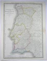
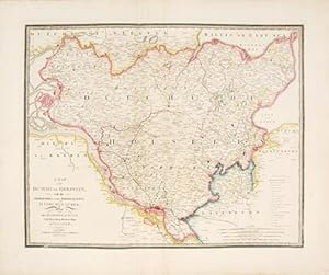
Chorographic Map of the Kingdom of Portugal Divided into its Grand Provinces.
Verlag: London, 1838
Anbieter: Alexandre Antique Prints, Maps & Books, Toronto, ON, Kanada
Bewertung:
Karte
Size : 768x540 (mm), 30.25x21.25 (Inches), Original Outline Coloring Very Good, minor browning to the right margin along the central fold.
-
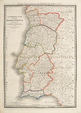
Chronographical Map of the Kingdom of Portugal Divided into its Grand Provinces.
Verlag: Published by James Wyld, Charing Cross East, Geographer To Her MAjesty. London. A New General Atlas of Modern Geography Consisting of a Complete Collection of Maps of the Four Quarters of the Globe; Delineating their Physical Features and Coloured to show the Limits of their respective states. c1853, 1853
Anbieter: Peter Harrington. ABA/ ILAB., London, Vereinigtes Königreich
Verbandsmitglied: ABA ILAB PBFA
Bewertung:
A large and detailed map of Portugal. James Wyld was successor to William Faden, one of the luminaries of late eighteenth century publishing in England. Wyld maintained the high standard of graphic and factual excellence that had been established by his predecessor and his maps are among the finest published in the early nineteenth century Copper engraving. Original outline colour. Very good condition. 54 x 77 cm (21 x 30 inches).