Gesamtpreis (1 Artikel Artikel):
Versandziel:

george philip ltd (12 Ergebnisse)
Direkt zu den wichtigsten Suchergebnissen
Produktart
- Alle Produktarten
- Bücher (10)
- Magazine & Zeitschriften
- Comics
- Noten
- Kunst, Grafik & Poster
- Fotografien
- Karten (2)
-
Manuskripte &
Papierantiquitäten
Zustand
Einband
Weitere Eigenschaften
- Erstausgabe
- Signiert
- Schutzumschlag
- Angebotsfoto (9)
Land des Verkäufers
Verkäuferbewertung
-

Der neue Weltatlas. Aktualisierte Ausgabe mit allen Staaten der Welt. Übersetzung: Maria Prechtl.
Verlag: Hamburg, Merit 1996., 1996
Anbieter: Antiquariat Markus Wolter, Emmendingen bei Freiburg, Deutschland
Bewertung:

31 x 23 cm. 160 S. Ill. OPp. Gutes Exemplar. Der Versand erfolgt als Päckchen (EUR 4,79 Inlandsporto). Bitte bestellen Sie nur, wenn Sie dieser Portoanpassung zustimmen können.
-
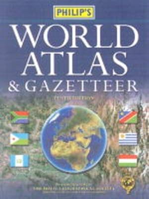
Philip's World Atlas and Gazetteer
Verlag: Philip's, 2002
ISBN 10: 0540082341ISBN 13: 9780540082346
Buch
Zustand: Good. Most items will be dispatched the same or the next working day. Small Tears to the Dust Jacket, Slipcase, or cover.
-
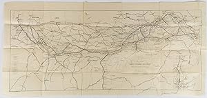
[Jigsaw Maps] The World on Mercator's Projection. Scotland. Europe
Verlag: London: George Philip & Son Limited [c.1920]., 1920
Anbieter: Bow Windows Bookshop (ABA, ILAB), Lewes, Vereinigtes Königreich
Verbandsmitglied: ABA ILAB PBFA
Bewertung:
Three jigsaw maps of the world, Scotland and Europe, each c. 24 x 32 cm. Colour printed on paper, mounted on wood and dissected into multiple small pieces. All pieces present and in very good condition. The world map published after 1917, featuring the Union of Soviet Socialist Republics. Similarly the Europe map shows the Serb-Croat-Slovene State, created in 1918 and superceded by Yugoslavia in 1929. The world map is subtitled "British Empire Coloured Red".
-
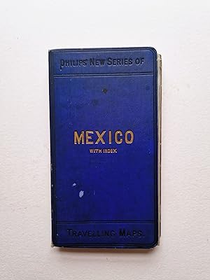
Mexico with Index/ Mexico and Central America
Verlag: George Philip & Son Ltd London, Liverpool, 1900
Anbieter: Angelika C. J. Friebe Ltd. - MapWoman, Dorking, Vereinigtes Königreich
Bewertung:
Karte
Hardcover. Zustand: Fair. colourprinted folding map; overall 53 x 64 cm, folds down to 17 x 9 cm. folds as issued; some discolouration; some wear and tear; some creases; some minor marginal tears not affecting the image; some small tears in crossfolds; o/w g cond. blue cloth binding with index; wear and tear; some staining and soiling; o/w fair cond. A very attractive and very detailed map of Mexico and Central America, with parts of Southern America. With inset if Isthmus of Panama.
-
Philips' Planisphere Showing The Principal Stars Visible For Every Hour In The Year. George Philip & Son, Ltd., The London Geographical Institute, 32 Fleet Street, London, E.C.4. Philip, Son & Nephew, Ltd., Liverpool, 1. Printed in Great Britain By George Philip And Son, Ltd., London.
Verlag: London: [c1925]., 1925
Anbieter: D & E LAKE LTD. (ABAC/ILAB), Toronto, ON, Kanada
Bewertung:

No Binding. Zustand: Good. No Jacket. blue cardboard & revolving brown leather discs (light wear to extremities). measuring 31 cm in diameter. Verso 'Explanation' & 'A Selection of Popular Astronomical Aids'. "The gilt figures on the leather disc represent clock time On the movable cardboard disc are marked the months of the year To find that part of the Heavens visible at any stated time, revolve the movable disc till the day of the month marked upon its edge, corresponds with the time of day or night figured upon the leather disc."(Verso).
-
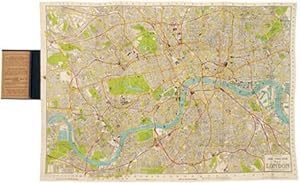
Philip's Tape Indicator map of London.
Verlag: London: c 1910, 1910
Anbieter: Peter Harrington. ABA/ ILAB., London, Vereinigtes Königreich
Verbandsmitglied: ABA ILAB PBFA
Bewertung:
An attractive and very detailed plan of Edwardian London, produced by George Philip and Son. Although the plan lacks the original tape indicator (not uncommon), it still has original comprehensive booklet containing an alphabetical listing of all streets, public buildings etc. Tram routes, underground and over ground railways are shown, and postal districts are defined. All major thoroughfares, public parks, commons, gardens, fields and grounds are coloured and highlighted. Map extent is from Peckham and Hackney in the east to Barnes and Willesden in the west. Size: 895 x 625 mm. Lithograph, dissected on linen and printed in colour. In original cloth embossed dark green boards. In very good condition. Unframed.
-
[London n.d. ca.1900], Philips'. Red cloth folding case,very good, some old discoloration, else clean, solid, [24]p. + cover, case size 10 x 18.8 cm., color folding map opens to 67 x 53.8 cm., linen backed, very nice early work. SCARCE An excellent early folding map, with nice linen backing. The work is printed in color, and shows English Miles, Kilometers, Geographical Miles, and shows from about 84 degrees west to ca. 135 degrees east; from ca 12 degrees south up to ca 55 degrees north. This includes Sakhalin, Karafuto Hokkaido, all of Japan, Korea, stretching down through the Liu Kiu or Luchu Islands [Ryukyu or Okinawa]. to Formosa or Taiwan, and the tip of Luzon. The China Sea, showing all of China, from Hainan Island up the coast to Siberia [Russia], Korea, Manchuria, Koko Nor Mongolia, Chinese Turkistan, Tibet, India, Burma, Shan States, Laos & Tonking [North Vietnam]. * China area shows all provinces of China, with provinces done in green outline, shows a large number of small towns, villages, rivers, lakes, mountains, shipping lines, based on the London Geographic Institute projection. * This is a nice work, with cloth backing, easily opens and folds back into the cloth covers. * CONDITION: Very solid item, a small amount of covers discolored, else map is excellent and solid, with the index pages to the left, which are also very clean and solid. *.
-

Philips\ Comprehensive School Atlas of Ancient and Modern Geography
Verlag: CHIZINE PUBN, 2018
ISBN 10: 137788001XISBN 13: 9781377880013
Buch
Zustand: New.
-

Philips\ Introductory School Atlas
Verlag: FRANKLIN CLASSICS, 2018
ISBN 10: 034201871XISBN 13: 9780342018710
Buch
Zustand: New.
-

Gebunden. Zustand: New.
-
Map of the East Indian Railway showing stations and mileage by Shortest route.
Verlag: E. I. R. Press [circa1910.], Calcutta., 1910
Anbieter: Asia Bookroom ANZAAB/ILAB, Canberra, ACT, Australien
Bewertung:
Folding engraved map 33.5 x 73.5 cm, river systems in blue, attractively bursting the borders of the map, inset map of the network into Calcutta, legend noting stations, lines under construction and foreign railways; original folds, two small fold splits with no loss, slight overall toning more noticeable at the folds, in very good condition. Attractive map capturing one of the busiest areas of a staggeringly vast railway network. The Barharwa-Azimganj-Katwa loop is marked under construction. Scarce.
-
Manitoba With Parts of Saskatchewan & Ontario
Verlag: George Philip & Son, Ltd c. 1890., London., 1890
Anbieter: Alexandre Antique Prints, Maps & Books, Toronto, ON, Kanada
Bewertung:
Karte
Part of Philip\'s New Series of Imperial Maps for Tourists and Travelers. The map provides detailed information on Manitoba, Eastern Saskatchewan and Northern Ontario. Various railways are shown. The map depicts rivers, settlements, and territories of the first nation people. , Size : 502x592 (mm), 19.75x23.30 (Inches), Hand Colored in Outline Very Good, Folding map laid on original canvas.

![Bild des Verkäufers für [Jigsaw Maps] The World on Mercator's Projection. Scotland. Europe zum Verkauf von Bow Windows Bookshop (ABA, ILAB)](https://pictures.abebooks.com/inventory/md/md4356464475.jpg)