Gesamtpreis (1 Artikel Artikel):
Versandziel:

cook james hawkesworth john (16 Ergebnisse)
Direkt zu den wichtigsten Suchergebnissen
Produktart
- Alle Produktarten
- Bücher (16)
- Magazine & Zeitschriften
- Comics
- Noten
- Kunst, Grafik & Poster
- Fotografien
- Karten
-
Manuskripte &
Papierantiquitäten
Zustand
Einband
Weitere Eigenschaften
- Erstausgabe (5)
- Signiert
- Schutzumschlag
- Angebotsfoto (12)
Land des Verkäufers
Verkäuferbewertung
-
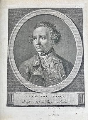
Relation des voyages entrepris par ordre de sa majesté britannique, et successivement executes par le commodore Byron, le capitaine Carteret, le capitaine Wallis & le capitaine Cook, dans les vaisseaux le Dauphin, le Swallow & l'Endeavour. Paris, Saillant et Nyon, Panckouke, 1774.Voyage dans l'hémisphčre austral, et autour du monde, fait sur les vaisseaux de roi l'Aventure & la Resolution, en 1772, 1773, 1774, & 1775. dans lequel on a inséré la relation du capitaine Furneaux, & celle de MM. Forster. Paris, Hôtel de Thou, 1778.Troisičme Voyage., ou Voyage ŕ l'Océan Pacifique, ordonne par le roi d'Angleterre, pour faire des decouvertes dans l'hémisphere nord, pour déterminer la position & l'étendue de la cote ouest de l'Amérique septentrionale, sa distance de l'Asie, & résoudre la question du passage au Nord.
Verlag: Hôtel de Thou, Paris, 1785
Ensemble de 18 vol. in-8 et 3 vol. d'atlas in-4 de 52-67-88 planches, demi-veau havane, dos lisse orné de filets dorés, pičces de titre et de tomaison en veau vert (reliure de l'époque). Deuxičme édition française aprčs l'édition in-4 publiée la męme année, et premičre édition au format in-8 des trois voyages de Cook.La traduction des deux premiers voyages a été assurée par Suard, et Demeunier pour le troisičme voyage. James Cook, célčbre navigateur anglais, apporta une contribution trčs importante a la connaissance du Pacifique grâce a ses nombreuses levées hydrographiques, révélant l'existence d'un hémisphčre océanique. Au cours de sa premičre expédition, de 1768 a 1771, il découvrit l'archipel des îles de la Société, la Nouvelle Zélande, les cotes orientales de l'Australie qu'on englobait jusqu'alors dans l'hypothétique continent austral. En 1772, lors de son second voyage, il visita des îles Marquises, les Nouvelles Hébrides et la Nouvelle Calédonie. Le troisičme voyage eut lieu entre 1776 et 1780 dans l'océan Pacifique ; c'est lors de ce voyage que James Cook trouva la mort d'un coup de poignard ŕ Hawaii.Provenance : Anthelme-Michel-Laurent de Migieu (1723-1788), marquis de Savigny-lčs-Beaune, bibliophile bourguignon, avec ex-libris manuscrit ŕ la plume, accompagné d?un prix d?achat, ŕ la fin du 11e volume : Demigieu 1785. Cachet Bibliothčque de Laplanche.Bel exemplaire complet de toutes les planches et cartes requises. (Infime défaut de papier avec perte d'un mot (III, p. 342) ; petite déchirure sans perte (VIII, p. 363) ; tache de rousseurs (IX, p. 37).
-
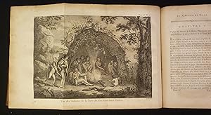
The Landing At Middleburgh One of the Friendly Isles
Verlag: 1778-1785, 1778
Zustand: Very Good. This fascinating engraving is from Captain James Cook & John Hawkesworth's Relation des Voyages entrepris par ordre de Sa Majesté Britannique. Or A Voyage towards the South Pole, and Round the World. Performed in His Majesty's Ships the Resolution and Adventure, In the years 1772, 1773, 1774, and 1775. In which is included Captain Furneaux's Narrative of his Proceedings in the Adventure during the Separation of the Ships. The work was published in Paris by Hotel de Thou from 1778 to 1785. It is an account of Cook's second voyage on which he was directed to circumnavigate the globe as far south as possible to search for any southern continent. "The famous accounts of Captain Cook's three voyages form the basis for any collection of Pacific books. In three great voyages Cook did more to clarify the geographical knowledge of the southern hemisphere than all his predecessors had done together. He was really the first scientific navigator and his voyages made great contributions to many fields of knowledge." (Hill) "Cook earned his place in history by opening up the Pacific to western civilization and by the foundation of British Australia. The world was given for the first time an essentially complete knowledge of the Pacific Ocean and Australia, and Cook proved once and for all that there was no great southern continent, as had always been believed. He also suggested the existence of antarctic land in the southern ice ring, a fact which was not proved until the explorations of the nineteenth century." (Printing and the Mind of Man p.135) "The success of Cook's first voyage led the Admiralty to send him on a second expedition, which was to circumnavigate the globe as far south as possible in search of any southern continents . The men of this expedition became the first to cross the Antarctic Circle. Further visits were made to New Zealand, and on two great sweeps Cook made an astonishing series of discoveries and rediscoveries including Easter Island, the Marquesas, Tahiti and the Society Islands, Niue, the Tonga Islands, the New Hebrides, New Caledonia, Norfolk Island, and a number of smaller islands. Rounding Cape Horn, on the last part of the voyage, Cook discovered and charted South Georgia, after which he called at Cape Town, St. Helena and Ascension, and the Azores . This voyage produced a vast amount of information concerning the Pacific peoples and islands, proved the value of the chronometer as an aid to finding longitude, and improved techniques for preventing scurvy." (Hill p.123) 20 1/2" by 10 1/4.
-

Relation des voyages entrepris par ordre de Sa Majesté Britannique, actuellement régnante; pour faire des Découvertes dans l'Hémisphčre Méridional, et successivement exécutés par le Commodore Byron, le Capitaine Carteret, le Capitaine Wallis & le Capitaine Cook, dans les Vaisseaux le Dauphin, le Swallow & l'Endeavour: rédigée d'aprčs les Journaux tenus par les différents Commandants & les Papiers de M. Banks, par J. Hawkesworth. Et enrichie de Figures, & d'un grand nombre de Plans & de Cartes relatives aux Pays qui ont été nouvellement découverts, ou qui n'étaient qu'imparfaitement connus. Traduite de l'Anglois.
Erstausgabe
Paris, Chez Saillant et Nyon ; chez Panckoucke, 1774 ; 4 volumes in-4, XVI pp. + 1 f.n.ch. + XXXII + 388 pp. + 1 f.n.ch. + 536 pp. + 1 f.n.ch. + 394 pp. + VIII + 367 pp. + 52 ff. de cartes et planches interfoliés, plein veau marbré de l'époque, dos ornés ŕ nerfs, triple filet d'encadrement sur les plats, roulettes sur les coupes, tranches marbrées (petits manques de cuir ŕ quatre coins). Les 4 volumes. Chadenat, n°6104. Sabin, n°30940. O'Reilly, Tahiti, 368. Édition originale de la traduction française, donnée par Jean-Baptiste Suard, de cette compilation de récits d'expéditions britanniques, rédigée d'aprčs les journaux des commandants et les papiers de Joseph Banks (les pičces de titre indiquent "voyage de Banks"). Elle est illustrée de 52 planches hors texte, dont 30 cartes et 22 vues, dépliantes pour la plupart, gravées par Bénard, Duret, Godefroy, Delaunay et d'autres. L'ouvrage renferme notamment la premičre relation officielle du premier voyage de Cook autour du monde, traduite sur l'édition originale anglaise de 1773. Bel exemplaire malgré les petits défauts signalés ŕ quelques coins, bien conservé. 1774.
-
Relation des voyages entrepris par ordre de sa Majeste Britannique, actuellement regnante: Pour faire des decouvertes dans l'Hemisphere Meridional, et successivement executes par le Commodore Byron, le Capitaine Carteret, le Capitaine Wallis & le Capitaine Cook, dans les vaisseaux le Dauphin, le Swallow & l'Endeavour . Four volumes. Paris, 1774.
Verlag: 1774, 1774
Anbieter: Charlotte Du Rietz Rare Books (ILAB), Stockholm, Schweden
Bewertung:

Erstausgabe
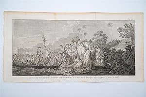
4to. Pp. (iv), iv, (ii), v-xvi, xxxii, 388 with 16 folding engraved maps and plates; pp. (vi), 536 and 16 engraved maps and plates, of which many folding; pp. (vi), 394, (1) and 17 engraved maps and plates, mostly folding; pp. viii, (ii), 367, (1) and 3 folding engraved maps and plates. A few plates with small tears at fold and one leaf in volume four (pp. 359/60) reinforced at outer margin without loss of text. Contemporary full calf, spines with five raised bands, decorated in gilt and with title labels, worn. Extremities rubbed, hinges weak and cracked (volume four upper board detached), and first volume's title label vanished. Occasionally some browning but overall a good copy. First French edition of this early important compilation of British maritime expeditions, edited by Hawkesworth, translated from the original English published in the previous year. Includes the first official account of Cook's first voyage during which he visited Tahiti to observe the transit of Venus across the disk of the sun, discovered the Society Islands, explored and surveyed New Zealand, and the eastern coast of Australia, naming it New South Wales. Other voyages included are: Byron's voyage to the Gilbert Islands, Wallace's discovery of Tahiti and Moorea, and Carteret's discovery of Pitcairn Island. The beautiful plates depict sea views, landscapes and natives. The maps show the new discoveries in the Pacific and the different routes of the ships. Many new areas were charted and several islands and coastlines were recorded for the first time. Borba de Moraes 395. Cf Hill 783. Sabin 30940.
-
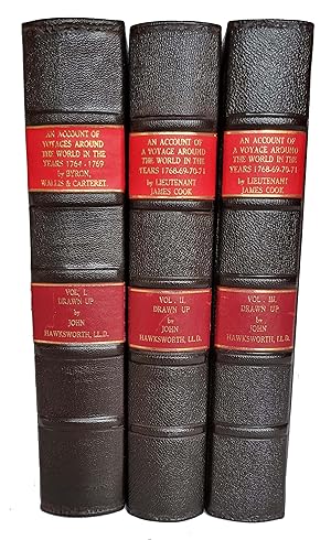
An Account of the Voyages Undertaken by the Order of His Present Majesty for Making Discoveries in the Southern Hemisphere, and Successively Performed by Commodore Byron, Captain Carteret, Captain Wallis and Captain Cook &c., &c.
Verlag: W. Strahan and T. Cadell, London, 1773
Anbieter: Arapiles Mountain Books - Mount of Alex, Castlemaine, VIC, Australien
Bewertung:
Erstausgabe
Hard Cover. Zustand: VG-. First Edition. Cook's First Voyage. 3 vols. 4to. modern full black leather gilt, blindstamped raised bands (new endpapers, some toning and marking, bound without half-titles, leaf edges a little thumbed, occ. misfolding to plans and charts, marginal tear to final leaf with only slight loss, occ. pencil marginalia, else generally clean and neat); pp. [xii (last blank)], xxxvi, [iv ('Directions for Placing the Cuts and Charts', last blank), 1-39, 360-676, with folding frontispiece + 19 other views, charts and plates (many folding, lacks 'Chart of the Streight of Magellan', as is usual in the first edition); xvi (last errata), 1-410 (last blank), with 21 views, charts and plates (lacks 'Chart of Cook's Streight in New Zealand'); vi (last errata), 411-800 (last blank), with 9 views, charts and plates; Very heavy set (7 kg), additional postage may be required for international and domestic delivery. A very good copy in a new binding. (Holmes, 3). Ex-libris Charles Scobie (ANARE, Macquarie Island, 1948), with his ownership signature dated 19-9-41 to first volume and his occasional pencil marginalia.
-
An Account of the Voyages Undertaken by the Order of His Present Majesty for Making Discoveries in the Southern Hemisphere, and successively performed by Commodore Byron, Captain Wallis, Captain Carteret, and Captain Cook, in the Dolphin, the Swallow, and the Endeavour
Verlag: W. Strahan and T. Cadell, London, 1785
Anbieter: James Cummins Bookseller, ABAA, New York, NY, USA
Bewertung:
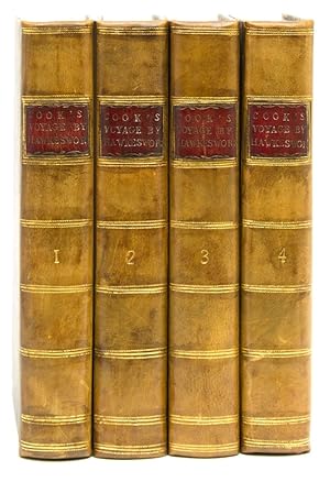
Third edition. Third edition. Large folding general chart of the expedition, folding chart of the Island of Otaheite, and 9 folding plates. [lvi], 362; [10], 447; [8], 416; [6], 429, [3] pp. 4 vols. 8vo. Cook's first voyage. Third edition of this chronicle of important English south-seas expeditions, including Cook's monumental first voyage, which is covered in volumes 2-4. The aim of Cook's first voyage was to sail to Tahiti to observe the transit of Venus; having done so Cook left Tahiti and discovered the Society Islands, explored New Zealand at great length, as well as the eastern coast of Australia, which he charted for 2,000 miles and named New South Wales. The expedition lasted from 1768-1771 and resulted in the annexation of both Australia and New Zealand by Britain, won Cook fame, and led to his two subsequent voyages. Beddie 665; ESTC T165111 Modern calf over marbled paper boards. Occasional foxing and minor offset, a very clean copy Large folding general chart of the expedition, folding chart of the Island of Otaheite, and 9 folding plates. [lvi], 362; [10], 447; [8], 416; [6], 429, [3] pp. 4 vols. 8vo.
-
An Account of the Voyages undertaken by the order of his Present Majesty for Making Discoveries in the Southern Hemisphere, and, successively performed by Commodore Byron, Captain Wallis, Captain Carteret, and Captain Cook, In the Dolphin, the Swallow, and the Endeavour: Drawn up from the Journals which were kept by the several Commanders, and from the Papers of Joseph Bankes, Esq.
Verlag: London: Printed for A. Strahan, and T. Cadell, 1773, 1773
Anbieter: Peter Harrington. ABA/ ILAB., London, Vereinigtes Königreich
Verbandsmitglied: ABA ILAB PBFA
Bewertung:
Second edition of the official account of Cook's first voyage. This edition, printed in the same year as the first, is preferred "as it is complete with the chart of the Strait of Magellan and the List of Plates, and contains new information in the form of a new preface [by Hawkesworth]" (Parsons). The primary purpose of Cook's voyage in Endeavour was the observation of the transit of Venus from Tahiti, which would enable the distance between the earth and the sun to be calculated. Another mission was to search for "Terra Australis", the great hypothetical southern continent balancing the northern land mass. The first voyage was to result in the discovery of the Society Islands, the circumnavigation of New Zealand, and the charting of the eastern coast of Australia. "Hawkesworth, an eminent London author, was chosen by Lord Sandwich and commissioned by the Admiralty to prepare these narratives for publication. [He] was expected to add polish to the rough narratives of sea men, and to present the accounts in a style befitting the status of the voyages as official government expeditions, intended to embellish England's prestige as a maritime power" (Hill). Although the book was a huge success, fast becoming a best-seller, it was disastrous for its editor: "He was publicly attacked on three different counts: by the captains for tampering with the texts of their journals, by prudish readers for reprinting descriptions of the sexual freedoms of the South Sea islanders, and by devout churchmen for impiety in the general introduction to the work, in which Hawkesworth had rashly challenged the doctrine of providential intervention. He was devastated by this critical barrage, and it was thought to be the main cause of his death. The rumour recorded by Malone that he killed himself with an overdose of opium is uncorroborated, but Fanny Burney's conviction that his health was destroyed by the vilification he suffered seems well founded" (ODNB). Hill 782; Howgego I, C173; Parsons Collection 90; Sabin 30934. Three volumes, quarto (290 x 235 mm). Contemporary diced calf, spines lettered direct, gilt single-fillet border to sides, spines and turn-ins, marbled endpapers, edges sprinkled blue. With 52 maps, charts and plates (most folding). Bindings expertly refurbished, a few marks to covers, scattered foxing, some offsetting (largely to or from plates), minor tear to plate 11 in vol. II. A very good copy.
-
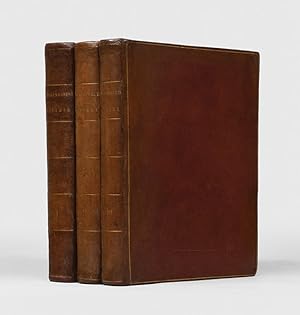
An Account of the Voyages undertaken by the order of His Present Majesty for making Discoveries in the Southern Hemisphere, and successively performed by Commodore Byron, Captain Wallis, Captain Carteret and Captain Cook, in the Dolphin, the Swallow, and the Endeavour. [Together with:] A Voyage towards the South Pole, and Round the World. Performed in His Majesty's Ships the Resolution and Adventure, in the years 1772, 1773, 1774 and 1775 [Together with:] A Voyage to the Pacific Ocean. Undertaken by the command of His Majesty, for making Discoveries in the Northern Hemisphere.
Anbieter: John Windle Antiquarian Bookseller, ABAA, San Francisco, CA, USA
Verbandsmitglied: ABAA ILAB IOBA
Bewertung:
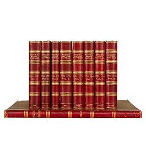
London: 1773-1785. 8 vols, 4to, and one vol. folio. Complete with 21 plates and charts in volume 1, 22 in volume 2 and 9 in volume 3, most of which are folding. 20th century half calf with linen paper-covered sides, backstrip tooled in gilt with green volume labels. Backstrips and board tips quite worn with splitting and some loss of calf, scattered foxing, signature "St. John" dated 1785 on the three title pages of the third voyage. Folio vol. boards detached, plates with some toning, foxing and marginal staining. Bookplates. § Complete set of Cook's Voyages: second (and best) edition of the first voyage, fourth edition of the second voyage, second edition of the third voyage. An internally attractive set in a worn binding. An excellent candidate for rebinding or enjoying in its current condition. The first voyage describes Cook's explorations of New Zealand, Australia, Tahiti, and other islands. The second voyage describes his southern voyages in search of a southern continent. The third is his north Pacific explorations of Alaska, the Northwest Coast, and Hawaii, where the great navigator met his death. Of equal importance as a text of exploration, a cartographic source for the numerous maps and charts included in the work, and a visual source of the engravings of fauna, flora, and inhabitants of the Pacific. In all, the entire set contains more than 200 maps and plates. Hill 782, 783. Howes C729a (3rd voyage). Holmes 5, 24, 47.
-

Relation Des Voyages Entrepris Par Ordre de Sa Majeste Britannique Actuellement Regnante. Tome 4
Verlag: HACHETTE LIVRE, 2019
ISBN 10: 2329286740ISBN 13: 9782329286747
Buch
Zustand: New.
-

Relation Des Voyages Entrepris Par Ordre de Sa Majeste Britannique Actuellement Regnante. Tome 1
Verlag: HACHETTE LIVRE, 2019
ISBN 10: 2329286767ISBN 13: 9782329286761
Buch
Zustand: New.
-

Relation Des Voyages Entrepris Par Ordre de Sa Majeste Britannique Actuellement Regnante. Tome 2
Verlag: HACHETTE LIVRE, 2019
ISBN 10: 2329286775ISBN 13: 9782329286778
Buch
Zustand: New.
-
Relation des voyages entrepris par ordre de sa majesté britannique, actuellement regnante, pour faire des découvertes dans l'hémisphčre méridional, et successivement exécutés par le commodore Byron, le capitaine Carteret, le capitaine Wallis & le capitaine Cook, dans les vaisseaux le Dauphin, le Swallow & l'Endeavour: réeigée d'aprčs les journaux tenus par les différens commandans & les papiers de M. Banks. Traduit de l'anglais.
Verlag: Paris, Saillant et Nyon, Panckoucke., 1774
Vol. 2 (von 4). 25,3x20 cm. 3 Bl., 536 S. Mit 16 (10 gefalt.) gestoch. Tafeln. Lederband der Zeit mit Rückenschild und Rückenvergoldung. Der zweite Band beschreibt die Reise von Samuel Wallis und James Cooks erste Reise auf der Endeavour. - 1) Voyage du capitaine Samuel Wallis: La Côte des Patagons - Passage du Détroit de Magellan ŕ Otahiti - Séjour ŕ Batavia - Séjour au Cap de Bonne-Espérance. - 2) Voyage du capitaine James Cook: Passage de Plymouth ŕ l'isle Madčre - Passage ŕ Rio-Janéiro. - Terre de Feu - Passage du Cap Horn - Otahiti - (Einband berieben. Rücken im Gelenk etwas eingerissen. Name auf Vortitelblatt. Seitenränder etwas gebräunt, stellenweise leicht fleckig). Sprache: französisch.
-
Relation des voyages entrepris par ordre de Sa Majeste Britanique . Pour faire des Decouvertes dans L Hemisphere Meridional
Verlag: Saillant et Nyon & Panckoucke,, 1774
Anbieter: Libreria Antiquaria Pontremoli SRL, Milano, MI, Italien
Bewertung:
Buch Erstausgabe
Paris, Saillant et Nyon & Panckoucke, [1774] MDCCLXXIV, Prima edizione francese. Ex libris nobiliare. Professionale restauro alle cerniere ma esemplari in ottimo stato di conservazione, grandi margini. James Cook (Marton, 27 ottobre 1728 Kealakekua, 14 febbraio 1779) č stato uno dei piů importanti esploratori britannici. Tra il 1768 e il 1779 compě tre viaggi nell'Oceano Pacifico nel corso dei quali realizzň il primo contatto europeo con le coste dell'Australia e le Hawaii, oltre alla prima circumnavigazione ufficiale della Nuova Zelanda. Il primo volume inizia con la spedizione in navigazione verso Rio de Janeiro, e copre il passaggio attraverso lo Stretto di Magellano, rappresentato in una dettagliata carta pieghevole, che spesso manca, qui presente. L'opera č riccamente illustrata con mappe, vedute di cittŕ, fauna e costumi locali. Il viaggio era destinato principalmente alle Indie Orientali, ma il vero scopo era fare scoperte nei mari del sud. Sbarcato in Patagonia, riferě degli indiani alti otto piedi e infine avvistň le Falkland che rivendicň come territorio inglese. Il viaggio toccň in fine Filippine, Sumatra, Capo di Buona Speranza prima di rientrare in Inghilterra. Cfr. Graesse, II, 258; Brunet, II, 254; Sabin 30940; Borba de Moraes 395. 4 voll., in 4°, bella legatura in piena pelle con stemma in oro al piatto anteriore; titoli in tassello in oro al dorso, pp. [4] xxxii 388; [6], 536 [2]; [6] 394 [4]; [2] viii, 367 [1]; carta bianca all inizio e fine di ogni volume e 52 mappe e tavole incise, per lo piů volte ripiegate o a doppia pagina. Prima edizione francese. Ex libris nobiliare. Professionale restauro alle cerniere ma esemplari in ottimo stato di conservazione, grandi margini. bella legatura in piena pelle con stemma in oro al piatto anteriore; titoli in tassello in oro al dorso,
-
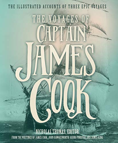
The Voyages of Captain James Cook: The Illustrated Accounts of Three Epic Pacific Voyages
Verlag: Voyageur Press 06 O, 2016
ISBN 10: 0760350299ISBN 13: 9780760350294
Buch
Hardcover. Zustand: Very Good. The Voyages of Captain James Cook: The Illustrated Accounts of Three Epic Pacific Voyages This book is in very good condition and will be shipped within 24 hours of ordering. The cover may have some limited signs of wear but the pages are clean, intact and the spine remains undamaged. This book has clearly been well maintained and looked after thus far. Money back guarantee if you are not satisfied. See all our books here, order more than 1 book and get discounted shipping. .
-
The three voyages of Captain James Cook
Anbieter: Douglas Stewart Fine Books, Armadale, VIC, Australien
Bewertung:
Erstausgabe
1. An account of the voyages undertaken by the order of his present Majesty for making discoveries in the southern hemisphere, and successively performed by Commodore Byron, Captain Wallis, Captain Carteret, and Captain Cook, in the Dolphin, the Swallow, and the Endeavour: drawn up from the journals which were kept by the several commanders, and from the papers of Joseph Banks, Esq; by John Hawkesworth, Ll.D. in three volumes. Illustrated with cuts, and a great variety of charts and maps relative to countries now first discovered, or hitherto but imperfectly known. London: W. Strahan and T. Cadell, 1773. First edition. Three volumes, quarto, late nineteenth century quarter straight-grained Morocco over papered boards by Morrell, his binder's stamp to first leaf, spines in compartments lettered in gilt with gilt lines, unusual gilt-tooled corner pieces to the upper and lower boards, a few scuffs and pale foxing to the boards, top edge gilt, others uncut, vol. I pp. [xii]; xxxvi; 676 (the numbering skips from 139 - 360 as per Beddie); vol. II pp. xv; [i]; 410, vol. III pp. [vi]; 411 - 799, without the[4] pp."Directions for placing the cuts." leaf (as commonly found in early issues); 51 engraved plates, maps and charts (41 folding, one backed on linen), occasional toning and offsetting, with the large folding map of the Straits of Magellan, not always present. "The first voyage under Captain Cook's command on the Endeavour was primarily of a scientific nature. The expedition was to sail to Tahiti in order to observe the transit of Venus across the disk of the sun, to determine the earth's distance from the sun, and also to carry on the geographical discovery that John Byron had started. Entering the Pacific around Cape Horn, Cook reached Tahiti in 1769 and carried out the necessary astronomical observations.Leaving Tahiti in July, Cook discovered, named, and charted the Society Islands, and then, heading southwest, explored New Zealand, then headed towards Australia and discovered and charted the eastern coast for 2,000 miles, naming the area New South Wales. Both Australia and New Zealand were annexed by Britain as a result of this voyage which began in 1768 and ended in 1771." (Hill). Beddie 648; Hill (2004) 782; Holmes 5 2. A voyage towards the South Pole, and round the world. Performed in His Majesty's ships the Resolution and Adventure, in the years 1772, 1773, 1774, and 1775. Written by James Cook, Commander of the Resolution. In which is included Captain Furneaux's narrative of his proceedings in the Adventure during the separation of the ships.In two volumes. Illustrated with maps and charts, and a variety of portraits of persons and views places drawn during the Voyage by Mr. Hodges and engraved by the most eminent Masters.London :W. Strahan and T. Cadell, 1777. First edition.Two volumes, quarto, late nineteenth century quarter straight-grained Morocco over papered boards by Morrell, his binder's stamp to first leaf, spines in compartments lettered in gilt with gilt lines, unusual gilt-tooled corner pieces to the upper and lower boards, a few scuffs and pale foxing to the boards, top edge gilt, others uncut, vol. 1 pp. xl; 378; vol. II pp. [viii]; 396; 64 engraved maps, plates and charts, some folding (a few with expert relining on linen or paper with mended tears). Beddie 1216; Hill (2004) 358; Holmes 24 The voyage where 'Cook proved there was no "Terra Australis" which supposedly lay between New Zealand and South America . [and] the first to cross the Antarctic Circle . This voyage produced a vast amount of information concerning the Pacific peoples and islands, proved the value of the chronometer as an aid in finding longitude, and improved techniques for preserving scurvy, in addition to the aforementioned discoveries." (Hill). 3. A Voyage to the Pacific Ocean.Undertaken, by the command of His Majesty, for making discoveries in the Northern Hemisphere . Performed under the direction of Captains Cook, Clerke, and Gore, in his majesty?s ships the Resolution and Discovery; in the years 1776, 1777, 1778, 1779, and 1780. London : Printed by W. and A. Strahan for G. Nicol, 1784. First edition. Three volumes, quarto and atlas folio,late nineteenth century quarter straight-grained Morocco over papered boards by Morrell, his binder's stamp to first leaf, spines in compartments lettered in gilt with gilt lines, unusual gilt-tooled corner pieces to the upper and lower boards, a few scuffs and pale foxing to the boards, scuff with loss to the upper board of the third volume, top edge gilt, others uncut, vol. I pp. [viii]; xcvi; 421; [blank]; vol. II pp. [xii]; 549; [blank]; vol. iii pp. [xi]; [blank]; 558, 24 engraved maps and charts (thirteen folding); the atlas folio with 61 plates and 2 folding charts (one plate with a repaired tear), occasional foxing and marks. The official account of Cook's third voyage, including his death on the islands of Hawaii, the discovery 'Cook judged his most valuable discovery' - Hill. 'One of the most important English books published in the last quarter of the eighteenth century.' (Forbes). Beddie 1543; Hill (2004) 361; Holmes 47 A magnificent set ofthe official account of Cook's voyages, finely illustrated with maps and plates. Finely bound by the venerable London firm of Morell in the late nineteenth century, this exceptional collection of the complete set of voyages of Cook is distinguished by its full, wide margins and rich, dark impressions. Provenance: E. Joseph, Bookseller, London Private collection, Melbourne, acquired from the above in 1963 (letter enclosed) acquired from the above.
-
An Account of the Voyages Undertaken by the Order of His Present Majesty for Making Discoveries in the Southern Hemisphere . in the Dolphin, Swallow and Endeavour (with) folding plates ?View of Endeavour River? and ?The Kanguroo?. Volumes III & IV
Verlag: W. Strahan and T. Cadell, London, 1785
Anbieter: Muir Books -Robert Muir Old & Rare Books - ANZAAB/ILAB, PERTH, WA, Australien
Bewertung:
Full Calf. William Bryne and George Stubbs (after) (illustrator). 3rd edition. 3rd ed. (first octavo edition), two volumes (of four). Vol.III: pp.(viii), 416, five fold engraved plates, closed tear along upper fold and tape remains to rear of 'Endeavour' plate, some darkening to folds, light off-setting opp. plates, lacking r.f.e.p. Vol.IV: pp.(vi), 429, (ii, publisher's adverts), two engraved folding plates, lacking r.f.e.p. and creased f.f.e.p., water-staining to edges of prelims, t.p. and contents, not affecting text. Prev owner's ink signature and date to f.f.e.p. of both volumes, "George Mundy, Sept. 19th, 1790" (1792 in other volume) with his contemporary book-plates (G.M.) to front paste-down in each volume. Both volumes full calf, cnrs and edges rubbed, spine worn, green and red titled leather labels to each volume. Engraved folding plates in volume four, "A View of Endeavour River on the Coast of New Holland" and "The Kanguroo, an animal found on the Coast of New Holland". Very good and generally clean condn, the two volumes complete with all plates. First English octavo edition, volumes 3 and 4 only, with the two folding plates, "A View of Endeavour River"on the Coast of New Holland" and "The Kanguroo". Beddie 665.

![Bild des Verkäufers für An Account of the Voyages undertaken by the order of His Present Majesty for making Discoveries in the Southern Hemisphere, and successively performed by Commodore Byron, Captain Wallis, Captain Carteret and Captain Cook, in the Dolphin, the Swallow, and the Endeavour. [Together with:] A Voyage towards the South Pole, and Round the World. Performed in His Majesty's Ships the Resolution and Adventure, in the years 1772, 1773, 1774 and 1775 [Together with:] A Voyage to the Pacific Ocean. Undertaken by the command of His Majesty, for making Discoveries in the Northern Hemisphere. zum Verkauf von John Windle Antiquarian Bookseller, ABAA](https://pictures.abebooks.com/inventory/md/md31218402351.jpg)