
Gesamtpreis (1 Artikel Artikel):
Versandziel:

cook james benard robert (4 Ergebnisse)
Direkt zu den wichtigsten Suchergebnissen
Produktart
- Alle Produktarten
- Bücher (3)
- Magazine & Zeitschriften
- Comics
- Noten
- Kunst, Grafik & Poster
- Fotografien
- Karten (1)
-
Manuskripte &
Papierantiquitäten
Zustand
- Alle
- Neu
- Antiquarisch/Gebraucht
Einband
- alle Einbände
- Hardcover
- Softcover
Weitere Eigenschaften
- Erstausgabe
- Signiert
- Schutzumschlag
- Angebotsfoto
Land des Verkäufers
Verkäuferbewertung
-
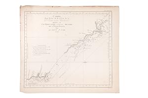
![Bild des Verkäufers für Carte d'une partie de la cote de la N[ouvel]le. Galles Merid[iona]le. depuis le Cap Tribulation jusqu'au détroit de l'Endeavour. zum Verkauf von Peter Harrington. ABA/ ILAB.](https://pictures.abebooks.com/inventory/md/md2717926128.jpg)
Carte d'une partie de la cote de la N[ouvel]le. Galles Merid[iona]le. depuis le Cap Tribulation jusqu'au détroit de l'Endeavour.
Verlag: [Paris: Saillant et Nyon, & Panckoucke, 1774], 1774
Anbieter: Peter Harrington. ABA/ ILAB., London, Vereinigtes Königreich
Verbandsmitglied: ABA ILAB PBFA
Bewertung:

An interesting chart of the north-eastern coast of Australia discovered by Cook in 1770, showing the Endeavour River and the Endeavour Strait, so named by Cook after his ship was careened and repaired on the banks of the river following grounding on a coral reef offshore, the site of present day Cooktown. From an early French edition of Cook's Voyages, vol. IV, plate 3. The Printed World III, item 165 Copper engraving. Later colour. Good condition, some offset and a little browning to left of central fold. Size: 33 x 29 cm. (13 x 11˝ inches).
-

Vue de la Côte du Japon lorsque nous la vimes pour la 1ere fois la Colline A restant dans l'O. ŕ 3 Millea
Verlag: 1785]., [Paris,, 1785
Anbieter: Daniel Crouch Rare Books Ltd, London, Vereinigtes Königreich
Verbandsmitglied: ABA ILAB PBFA
Bewertung:

Karte
From the French edition of Captain Cook's journal Engraved map. A map of the coast of Japan from the French edition of Captain Cook's 'A Voyage to the Pacific Ocean'. Captain James Cook made three major voyages to the Pacific. The first voyage, with HMS Endeavour, from 1768 1771, was ostensibly made to observe the Transit of Venus, but also to search for the mythical Great Southern Continent supposed to lie somewhere between New Holland and South America. Cook became the first European to set foot on New Zealand, and named the land New South Wales. During the second voyage, with HMS Resolution and Adventure, from 1772 1775, Cook made the first crossing of the Antarctic Circle. In his third and final voyage, with HMS Resolution and Discovery, from 1776 1780, Cook became the first European to discover Hawaii and showed that there was no navigable northern passage from the Atlantic to the Pacific. He died during a skirmish with natives in Hawaii. Cook's journals were published after each voyage. This map is from the 1785 French translation of the journals of his third voyage, 'A Voyage to the Pacific Ocean', first published in 1784.
-
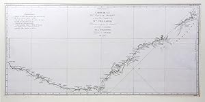
Carte d'une Partie de la Cote de la Nle. Galles Meridle. depuis le Cap Tribulation jusqu'au Detroit de L'Endeavour, par le Lieut. J.Cook
Verlag: Saillant et Nyon, Paris, 1774
Anbieter: Hordern House Rare Books, Surry Hills, NSW, Australien
Bewertung:
Engraved map, 295 x 335 mm.; original folds. French edition of Cook's chart, based on the original engraved chart in Hawkesworth's official account of the first voyage. This was the earliest charting of the coast of Queensland; it details the tracks and anchorages of the Endeavour as the expedition sailed north along the coastline in 1770, and commemorates one of the most memorable passages of Cook's first voyage. Far North Queensland was a difficult passage for the Endeavour: the ship ran aground on a shoal near the Hope Isles and required numerous repairs at Endeavour River. The expedition's naturalists, Joseph Banks, Herman Spöring and Daniel Solander, used the delay as an opportunity to collect Australian flora for European study. Cook's chart shows the exact spot of the reef where the ship went aground, as well as Endeavour River, where they beached the ship. The track to Cape York, including the passage through Providential Channel, is marked. The original manuscript chart from which this derives, now in the British Library, is reproduced in Historical Records of NSW (1893, plate 6). . In fine condition, with good margins.
-
Carte de la Nlle. Galles Meridle. Ou de la Côte Orientale de la Nlle. Hollande Découverte et visitée par le Lieutenant J. Cook.
Verlag: Saillant et Nyon, Paris, 1774
Anbieter: Hordern House Rare Books, Surry Hills, NSW, Australien
Bewertung:
Zustand: In fine condition. Engraved map, 370 x 785 mm.; original folds; mounted. Perhaps Cook's most famous chart, here in its first French version, prepared for the French language edition of the official account of the Endeavour voyage. The magnificent sweep of the east coast of Australia from Point Hicks to Cape York is testament to Cook's extraordinary achievement on the first voyage. Cook's original manuscript chart is in the British Library. Two contemporary English engraved versions are recorded by David, the version published in Hawkesworth's official account and another, upright in shape, that appears only in Wales' Astronomical Observations (1788). This French version is not recorded by David. .