
Gesamtpreis (1 Artikel Artikel):
Versandziel:

cook first voyage after lieutenant (1 Ergebnisse)
Direkt zu den wichtigsten Suchergebnissen
Produktart
- Alle Produktarten
- B¸cher (1)
- Magazine & Zeitschriften
- Comics
- Noten
- Kunst, Grafik & Poster
- Fotografien
- Karten
-
Manuskripte &
Papierantiquit‰ten
Zustand
- Alle
- Neu
- Antiquarisch/Gebraucht
Einband
- alle Einb‰nde
- Hardcover
- Softcover
Weitere Eigenschaften
- Erstausgabe
- Signiert
- Schutzumschlag
- Angebotsfoto
Land des Verk‰ufers
Verk‰uferbewertung
-
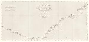
A Chart of New South Wales, or the East Coast of New Holland discover'd and explored by Lieutenant J. Cook, Commander of His Majesty's Bark Endeavour, in the year MDCCLXX
Verlag: London, 1773
Anbieter: Hordern House Rare Books, Surry Hills, NSW, Australien
Bewertung:

Engraved map, 345 x 774 mm, expertly mounted and framed. This finely engraved chart of the east coast of Australia is the earliest published charting of the coast of New South Wales. This area was first charted by James Cook on the Endeavour and was one of the most memorable passages of Cook's first voyage to Australia and the Pacific. This expedition was an initiative by the Royal Navy and the Royal Society to the South Pacific Ocean aboard HMS Endeavour, from 1768 to 1771. Detailed are the tracks and anchorages of the Endeavour as the expedition sailed north along the eastern seaboard in 1770. The chart depicts the route from Port Hicks in the East Gippsland region of Victoria, and includes Botany Bay, Port Jackson, Port Stephens, Hervey Bay as the expediton travels to the Endeavour Straits and Cape York. North Queensland was a difficult passage for the Endeavour, as the ship ran aground on a shoal near the Hope Isles and required numerous repairs at Endeavour River, present day Cooktown. The expedition's naturalists, Joseph Banks, Herman Spˆring and Daniel Solander, using the delay as an opportunity to collect exotic Australian flora. Although neither Banks nor Solander published their botanical findings, the two naturalists returned to England with a vast wealth of new discoveries. Delineated is the exact spot of the reef where the ship went aground, as well as "Endeavour River, where we beached the ship". The ongoing route to Cape York, including the passage through Providential Channel, is marked. The expedition re-entered known waters near New Guinea in late August, 1770. During the last part of the voyage, the expedition visited Batavia, Java and at the Cape of Good Hope and Africa, returning to England in July, 1771. The Endeavour arrived on the east coast in April, 1770 after six months in New Zealand where the first cartographic survey was completed. It sailed northwards along the east coast in search of a harbour in which to take on supplies. In late April it anchored at a place Cook later called Botany Bay. During the first landing two men, armed with spears and stones, tried to stop the British coming ashore. After a stand-off lasting ten or fifteen minutes the British fired muskets loaded with small shot, wounding one of the men in the leg. The Endeavour stayed a week at the bay, during which no direct contact was made with the Gweagal people, although both groups observed each other from a distance. (British Library). This first chart of New South Wales was prepared for James Hawkesworth's, Account. from the original manuscript map done by James Cook held in the British Library. The name, New South Wales came from Cook's journal, it is recorded that as the land looked like the south coast of Wales he named it New Wales then, changed the name in his journal to New South Wales. This engraved map is by William Whitchurch, (1748-1794) a London engraver and printer who worked on several charts from the voyages of James Cook. . With full margins and in very good condition.