
Gesamtpreis (1 Artikel Artikel):
Versandziel:

connor edward (24 Ergebnisse)
Produktart
- Alle Product Types
- Bücher (23)
- Magazine & Zeitschriften
- Comics
- Noten
- Kunst, Grafik & Poster
- Fotografien
- Karten (1)
- Manuskripte & Papierantiquitäten
Zustand
Einband
Weitere Eigenschaften
- Erstausgabe (1)
- Signiert
- Schutzumschlag
- Angebotsfoto (10)
Gratisversand
- Versand nach USA gratis
Land des Verkäufers
Verkäuferbewertung
-

Zustand: Good. New edition. Used book that is in clean, average condition without any missing pages.
-

Essential Medical Genetics, Includes Desktop Edition
Verlag: Wiley & Sons, Incorporated, John, 2011
ISBN 10: 1405169745ISBN 13: 9781405169745
Buch
Zustand: Very Good. 6 Edition. Used book that is in excellent condition. May show signs of wear or have minor defects.
Mehr Angebote von anderen Verkäufern bei ZVAB
Neu ab EUR 54,81
Gebraucht ab EUR 9,56
Mehr entdecken Softcover
-

Abandoned Stations on London's Underground: A Photographic Record
Verlag: Connor & Butler, 2000
ISBN 10: 0947699309ISBN 13: 9780947699307
Buch
Paperback. Zustand: Very Good. The book has been read, but is in excellent condition. Pages are intact and not marred by notes or highlighting. The spine remains undamaged.
-

London, Chatham and Dover Railway (v. 3) (London's Disused Stations)
Verlag: Connor & Butler, 2002
ISBN 10: 0947699333ISBN 13: 9780947699338
Buch
Paperback. Zustand: Very Good. The book has been read, but is in excellent condition. Pages are intact and not marred by notes or highlighting. The spine remains undamaged.
-

Conversation-Book in English and Swedish for the use of Schools and Travellers; Method Gaspey-Otto-Sauer;
Verlag: Julius Groos, 1907
Anbieter: books4less (Versandantiquariat Petra Gros GmbH & Co. KG), Welling, Deutschland
Bewertung:

Buch
Hardcover-Kleinformat. Zustand: Gut. 220 Seiten; Das hier angebotene Buch stammt aus einer teilaufgelösten wissenschaftlichen Bibliothek und trägt die entsprechenden Kennzeichnungen (Rückenschild, Instituts-Stempel.); leichte altersbedingte Anbräunung des Papiers; der Buchzustand ist ansonsten ordentlich und dem Alter entsprechend gut. Einbandkanten sind leicht bestoßen. In ENGLISCHER und SCHWEDISCHER Sprache. Sprache: Deutsch Gewicht in Gramm: 170.
-

Comprehension for Independent Readers Upper: Literal - Inferential - Evaluative: 2
Verlag: Prim-Ed Publishing, 2012
ISBN 10: 1846546087ISBN 13: 9781846546082
Buch
paperback. Zustand: New. BRAND NEW ** SUPER FAST SHIPPING FROM UK WAREHOUSE ** 30 DAY MONEY BACK GUARANTEE.
-

Spontaner Glaube. Ereignis und Erfahrung der charismatischen Erneuerung.
Verlag: Herder Verlag, Freiburg, 1974
ISBN 10: 3451170531ISBN 13: 9783451170539
Buch
Broschiert. 270 Seiten. Minimale Gebrauchssuren. Sehr gut. Sprache: Deutsch Gewicht in Gramm: 400.
-
Medical Genetics for the MRCOG and Beyond
Verlag: Cambridge University Press 2014-03-20, Cambridge, United Kingdom |New York, 2014
ISBN 10: 1107661307ISBN 13: 9781107661301
Buch
paperback. Zustand: New. Language: ENG.
-

Acrostic Sonnets, and Other Poems
Verlag: CHIZINE PUBN, 2018
ISBN 10: 1376875535ISBN 13: 9781376875539
Buch
Zustand: New. KlappentextThis work has been selected by scholars as being culturally important, and is part of the knowledge base of civilization as we know it. This work was reproduced from the original artifact, and remains as true to the origina.
-

Comprehension for Independent Readers Middle
Verlag: Prim-Ed Publishing, 2012
ISBN 10: 1846546079ISBN 13: 9781846546075
Buch
Zustand: New. Comprehension for independent readers - Middle offers a range of writing genres and activities to develop theskills required for comprehension. The aim is to provide pupils with the opportunity to work independently to extract information from different tex.
-

Zustand: Wie neu. Zustand: Wie neu | Seiten: 38.
-

A Promethean Legacy: Late Quaternary Vegetation History of Southern Georgia, the Caucasus
Verlag: Peeters, Leuven, 2011
ISBN 10: 9042923504ISBN 13: 9789042923508
Anbieter: ERIC CHAIM KLINE, BOOKSELLER (ABAA ILAB), Santa Monica, CA, USA
Bewertung:

Buch Erstausgabe
Hardcover. Zustand: near fine. First edition. Quarto (12" x 8-1/2"). xii, 419, (3)pp. Red cloth lettered in gilt. Illustrated throughout with statistical diagrams, photos and maps (1, in color). An ex-library copy with minimal rubber stamps on title page & at bottom of text block, otherwise fine. In this work, the author presents an original analysis of palaeoecological and archaeological data from Southern Georgia, demonstrating how past societies and environments interacted in this region of high biodiversity and ancient culture. New pollen records, including the first fire histories for the Caucasus region, are analysed using novel statistical techniques, providing insights into the region's climatic and vegetation history that challenge preconceived notions about the evolution of Georgia's diverse landscapes. Readers with an interest in the region's archaeology will find the synthesis of archaeological and palaeoenvironmental data in the chapter on human impact to be of great value, whereas those interested in Georgia's biogeography will find in the text and appendix a wealth of information, much of which has never before appeared in the English language. The text is thoroughly illustrated, including maps and descriptive notes on the present and past distribution of each of the major pollen types and vegetation units. (Publisher) Contents: Introduction -- Background -- Methods -- Modern pollen-vegetation relationships -- The Tbilisi area -- The Tsalka plateau -- 7. Holocene palaeovegetation maps of Georgia -- Human impact on the vegetation of southern Georgia -- Conclusion -- Appendices. A. Present and past pollen maps of Georgia -- B. Correlations with weighted averaging trends -- C. Pollen preparation method -- D. Radiocarbon dating -- E. Complete pollen diagrams. (OCLC) Supplement 34 of the Peeters series, "Ancient Near Eastern Studies.".
-
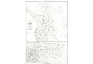
BRISBANE, Australia. Australia, East Coast: Queensland: Brisbane River surveyed by Staff Comr. Bedwell & Navg. Lieut. Connor. R.N. 1873 With corrections to 1899.
Anbieter: Antiquariat Dasa Pahor GbR, München, Deutschland
Bewertung:

Karte
This important landmark of the coastal surveying of Australia depicts the first advanced scientific survey of the estuary of the Brisbane River, featuring the capital of Queensland and its route of access to Moreton Bay. It is based on surveys conducted in 1873 by Commander Edward Parker Bedwell and Lieutenant Edward Connor, as part of an extraordinary effort jointly sponsored by the British Admiralty and the Queensland government. The chart was first issued in 1875, with the present example being of the third edition, printed in 1899, featuring new information gained over the preceding generation, as the chart is labeled in the lower margin "Large Corrections" up to "Sep. 1899". The chart is today very rare, the present example is the only one we have been able to locate as having appeared on the market in the last 25 years. The sea chart is divided into two sections, the upper, larger section features the mouth of the Brisbane River and the adjacent waters of Moreton Bay. The town o in the lower part of the section, and the waters feature copious hydrographic information, including bathymetric soundings, compass variations, navigational sightlines, remarks on hazards, with lighthouses and buoys heightened by red and yellow accents. The lower third of the sheet features the river from Gibson Island over to include downtown Brisbane as far west as Albert Park. Significantly, the map includes a fairly detailed early street plan of the city with all major buildings outlined and labeled, such as: 'House of Parliament', 'Government House', 'Public Offices', 'Town Hall', 'Theatre Royal', 'Opera House', 'St. Patrick's Roman Catholic Church', 'Synagogue', 'Masonic Hall', the 'Observatory', various banks, and many other curious sites. Queensland, with much of its coastline guarded by the Great Barrier Reef, and many of its best areas for settlement, such as Brisbane, located deep along inshore waters, was always considered to begerous r All of the great early surveyors, James Cook, Matthew Flinders, and Phillip Parker King had either sailed by or into Moreton Bay, but none had surveyed the estuary of the Brisbane River. The first survey of the river was carried out by Lieutenant John Oxley in 1823-4, aboard the HM Cutter Mermaid. This was done in preparation for the foundation of a penal colony in 1825, at North Quay, in what is now the city of Brisbane. This was followed, in 1839, by a survey of Moreton Bay and the approaches to the Brisbane River conducted by Commander John Clements Wickham, aboard the HMS Beagle, famously the ship that previously carried Charles Darwin on his legendary voyages of natural discovery. Wickham's survey resulted in the publication of the Plan of the North Entrance into Moreton Bay (1846), which featured the Brisbane River Estuary. Brisbane attained a high level of importance in 1859, when it was selected to become the capital of the newlestablished state of Queensland. However,he state's leaders had a major challenge on their hands, as Queensland's immense, intricate and unusually dangerous coastlines were not particularly well charted, compared to most other regions of the Australian littoral. As the road system was embryonic, and would remain so for quite some time, by far the most important means of transport was by water. The lack of accurate charts threatened to hinder Queensland's development, unless concerted action was taken. By 1860, even the maritime approaches to the state capital were not adequately mapped. Oxley's survey of the Brisbane River was not done to sufficiently high scientific standards, and the Wickham survey's coverage of the Brisbane River was of comparatively small scale and lacked critical detail. Moreover, the changing positions of the shoals in the Brisbane River and the adjacent parts of Moreton Bay also rendered Wickham and Oxley's charts somewhat outdated. Normallyibility for surveying Australia's coastlinusively on the British Admiralty. The problem, in this case, was that properly and thoroughly charting Queensland's coasts promised to be a remarkably expensive and time consuming process, an endeavor that was not sufficiently high on the Admiralty's list of priorities. In 1860, the state government proposed a progressive solution to the problem. It was estimated that supporting a proper hydrographic program for Queensland would cost Ł3,000 per annum. If the Admiralty would supply staff, instruments and provide for the publication of charts to the amount of Ł1,500 per annum, then the Queensland authorities agreed provide the surveyors with the use of vessels and lodging to a matching amount. In 1861, the Admiralty agreed to Queensland's proposal and Master James Jeffery was appointed as Queensland's first Admiralty Surveyor. Provisionally, a local vessel was hired to chart various points on the coast, such as the y Strait, Hervey Bay, and the mouth of the Mary River. Inhe Queensland government had a dedicated surveying vessel, the HMS Pearl, specially constructed. From 1864 to 1866, Jeffery surveyed parts of Moreton Bay and Keppel Bay. In 1866, Jeffery was replaced as Queensland's Admiralty Surveyor by Master (Staff-Commander from 1870) Edward Parker Bedwell (1834-1919). Bedwell joined the Royal Navy in 1848 and served under in the Crimean War. In 1854, he had the privilege of personally delivered the news of the key British victory at the Battle of Alma to the Royal Navy's Mediterranean Command in Malta. In 1857, he became a navy surveyor and was sent to chart parts of the rugged coastlines of British Columbia, where he learned skills that would prove invaluable in Australia. Bedwell continued Jeffery's survey of Moreton Bay, from 1866 to 1868, before moving on to chart other areas of Queensland's coasts, such as the Great Barrier Reef. In 1873, he was joined by Lieutenanrd Connor (1846-1903), who had previously worked on surveys in theerranean, the English Channel, and most notably in the Straits of Magellan. In 1873, Bedwell an.