Gesamtpreis (1 Artikel Artikel):
Versandziel:

James Cook, Endeavour (78 Ergebnisse)
Direkt zu den wichtigsten Suchergebnissen
Produktart
- Alle Produktarten
- Bücher (55)
- Magazine & Zeitschriften
- Comics
- Noten
- Kunst, Grafik & Poster (12)
- Fotografien
- Karten (11)
-
Manuskripte &
Papierantiquitäten
Zustand
Einband
Weitere Eigenschaften
Gratisversand
Land des Verkäufers
Verkäuferbewertung
-

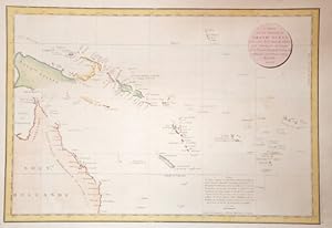
A Chart of Capt.n Carteret's Discoveries at New Britain, with Part of Capt.n. Cooke's Passage thro Endeavour Streights, & of Capt.n Dampier's Tract & Discoveries in 1699, & 1700, at New Guinea and New Britain.
Erscheinungsdatum: 1773
Anbieter: Altea Antique Maps, London, Vereinigtes Königreich
Verbandsmitglied: ABA ILAB PBFA
Bewertung:

Karte
London: Strahan & Cadell, 1773. Coloured. 245 x 645mm. Another one of Cook's achievements on his First Voyage was the confirmation that Torres Strait separated New Guinea and Australia, although Cook had expresssed doubt that it existed himself. This chart marks the southern coastline he verified, with the rest of the outline taken from earlier explorers. To the north of the island are the tracks of Dampier and Carteret around New Britain and New Ireland. Engraved by W.Whitchurch for Hawkesworth's important work 'An Account of the Voyages. for making Discoveries in the Southern Hemisphere', the official account of Cook's First Voyage.
-
A Chart of New South Wales, or the East Coast of New Holland discover'd and explored by Lieutenant J. Cook, Commander of His Majesty's Bark Endeavour, in the year MDCCLXX
Verlag: London, 1773
Anbieter: Hordern House Rare Books, Surry Hills, NSW, Australien
Bewertung:
Engraved map, 345 x 774 mm, expertly mounted and framed. This finely engraved chart of the east coast of Australia is the earliest published charting of the coast of New South Wales. This area was first charted by James Cook on the Endeavour and was one of the most memorable passages of Cook's first voyage to Australia and the Pacific. This expedition was an initiative by the Royal Navy and the Royal Society to the South Pacific Ocean aboard HMS Endeavour, from 1768 to 1771. Detailed are the tracks and anchorages of the Endeavour as the expedition sailed north along the eastern seaboard in 1770. The chart depicts the route from Port Hicks in the East Gippsland region of Victoria, and includes Botany Bay, Port Jackson, Port Stephens, Hervey Bay as the expediton travels to the Endeavour Straits and Cape York. North Queensland was a difficult passage for the Endeavour, as the ship ran aground on a shoal near the Hope Isles and required numerous repairs at Endeavour River, present day Cooktown. The expedition's naturalists, Joseph Banks, Herman Spöring and Daniel Solander, using the delay as an opportunity to collect exotic Australian flora. Although neither Banks nor Solander published their botanical findings, the two naturalists returned to England with a vast wealth of new discoveries. Delineated is the exact spot of the reef where the ship went aground, as well as "Endeavour River, where we beached the ship". The ongoing route to Cape York, including the passage through Providential Channel, is marked. The expedition re-entered known waters near New Guinea in late August, 1770. During the last part of the voyage, the expedition visited Batavia, Java and at the Cape of Good Hope and Africa, returning to England in July, 1771. The Endeavour arrived on the east coast in April, 1770 after six months in New Zealand where the first cartographic survey was completed. It sailed northwards along the east coast in search of a harbour in which to take on supplies. In late April it anchored at a place Cook later called Botany Bay. During the first landing two men, armed with spears and stones, tried to stop the British coming ashore. After a stand-off lasting ten or fifteen minutes the British fired muskets loaded with small shot, wounding one of the men in the leg. The Endeavour stayed a week at the bay, during which no direct contact was made with the Gweagal people, although both groups observed each other from a distance. (British Library). This first chart of New South Wales was prepared for James Hawkesworth's, Account. from the original manuscript map done by James Cook held in the British Library. The name, New South Wales came from Cook's journal, it is recorded that as the land looked like the south coast of Wales he named it New Wales then, changed the name in his journal to New South Wales. This engraved map is by William Whitchurch, (1748-1794) a London engraver and printer who worked on several charts from the voyages of James Cook. . With full margins and in very good condition.
-
A Journal of a Voyage Round the World in H.M.S. Endeavour 1768-1771
Verlag: Amsterdam/New York : N. Israel/Da Capo Press, 1967
Buch
Zustand: Good. Original leatherette binding, transperent dust jacket, 130,(3)p., large 8vo. Bibliotheca Australiana #14. Facsimile of the 1771 edition.
-
A Journal of a Voyage round the World in His Majesty's Ship Endeavour, in the years 1768, 1769, 1770 and 1771; Undertaken in Pursuit of Natural Knowledge, at the Desire of the Royal Society: containing All the various Occurrences of the Voyage, with Descriptions of several new discovered Countries in the Southern Hemisphere; and Accounts of their Soil and Productions; and of many Singularities in the Structure, Apparel, Customs, Manners, Policy, Manufactures, &c. of their Inhabitants
Verlag: Printed for T. Becket and P.A. De Hondt, in the Strand, London, 1771
Anbieter: Hordern House Rare Books, Surry Hills, NSW, Australien
Bewertung:
Erstausgabe
Zustand: A fine copy. Quarto; a fine copy in a Sangorski-style binding of half green morocco, spine panelled in gilt between raised bands. First edition of the earliest published account of Cook's first voyage to the Pacific: the rare first issue, with the leaf of dedication to 'The Right Honourable Lords of the Admiralty, and to Mr. Banks and Dr. Solander' inserted by the publishers to add authenticity. This was the first of a series of so-called "surreptitious accounts" of Cook's various voyages to appear in print: the Admiralty found it practically impossible to enforce their ruling that no unofficial publications should pre-empt the official and lengthier accounts of the voyages, naturally much slower in the press. In this case, however, legal action was taken against the publisher for using an unauthorised dedication, forcing removal of the leaf during publication. 'It is accordingly of the greatest rarity, and copies of the book containing the dedication are far more valuable than those without it.' (Davidson). In this large copy, the offending leaf has generous margins and retains its printed instruction to the binder "Place this next the title" (which also, interestingly, indicates that the leaf was printed quite separately from the rest of the work). The British public's eagerness for news of the voyage needed more than newspaper accounts, while the officially sanctioned narrative would be a long time coming. Published anonymously some two months after the return of the Endeavour and nearly two years before Hawkesworth's official account, the Cook scholar Beaglehole demonstrated that the sailor James Magra was the author. His illicit sale of his journal to the publishers might well have confirmed Cook's opinion of him: 'one of those gentlemen, frequently found on board Kings Ships, that can very well be spared, or to speake more planer good for nothing.'. He was a New Yorker and a loyalist. Whatever his skipper and the authorities may have thought of him, it was Magra who got the first description of the voyage into print -- the earliest printed account of the east coast of Australia, published even before acceptance of the name Botany Bay, here called Sting-ray Bay as Cook originally christened it. Magra later changed his name to Matra to claim a family inheritance. As Alan Frost has shown ("The Precarious Life of James Mario Matra: Voyager with Cook; American Loyalist; Servant of Empire", 1995) Matra used his experiences on the east coast of Australia to draft his 1783 proposal for a penal colony at Botany Bay. Never shy in self-promotion, he announced his hope of being made Governor. His plan, like Sir Joseph Banks's before and George Young's after him, had its effect on the planners of the First Fleet and he was called as an expert witness to the committee in charge of solving the question of transportation (see Frost, pp.113-122). His life has prompted a considerable literature, with multiple studies of his career and importance including those by G.B. Barton, George Anthony Wood, James Watson (who christened him the "Father of Australia", an accolade more often awarded to Joseph Banks), and more recently Antonio Giordano (who has him as "Australia's Spiritual Father") and Andrew Tink. .
-
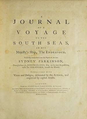
A Journal of a Voyage to the South Seas, in His Majesty's Ship, The Endeavour. Faithfully transcribed from the papers of the late Sydney Parkinson, Draughtsman to Joseph Banks, Esq. on his late expedition with Dr. Solander, round the World. Embellished with views and designs, delineated by the Author, and engraved by capital artists
Verlag: Printed for Stanfield Parkinson, London, 1773
Anbieter: James Cummins Bookseller, ABAA, New York, NY, USA
Bewertung:
Erstausgabe
First edition with the very rare "Explanatory Remarks" by Fothergill and postscript. Complete with frontispiece and 27 engraved plates (including 1 map). xxiv, 22, 212, 2 pp. Imperial 4to. With The Rare Explanatory Remarks by Fothergill. First edition of this important account of Cook's first voyage, based on the journal of Parkinson, who had been engaged by Sir Joseph Banks to serve as natural history draughtsman aboard the Endeavour. Parkinson died of dysentery on the homeward voyage, and his account was transcribed and published by his brother Stanfield Parkinson, who was forced by injunction to delay publication until Hawkesworth's official account appeared. "Parkinson made numerous drawings of botanical and other subjects, including landscapes and portraits of native chiefs . Banks spoke highly of his 'unbounded industry' in making for him a much larger collection of drawings than he anticipated. His observations, too, were valuable, and the vocabularies of South Sea languages given in his journal are of great interest" (Hill). This copy includes the rare "Explanatory Remarks" by John Fothergill, a Parkinson family friend who mediated an agreement between Stanfield Parkinson and Banks, both of whom laid claim to the journal, which would allow for the publication of the book. When Stanfield Parkinson included a scurrilous preface attacking Banks and misrepresenting his actions, an offended Fothergill purchased the remaining copies, inserting into them these 22 pages of remarks which sought to set the record straight. In 1784 he brought out a new edition of Parkinson's account which included the remarks, but copies of the first edition which include them are scarce on the market. Beddie 712; Hill 1308; Holmes 7; Howgego C173; Du Rietz 944; Sabin 58787 Contemporary tree calf, finely rebacked with gilt spine to period style. Fine Complete with frontispiece and 27 engraved plates (including 1 map). xxiv, 22, 212, 2 pp. Imperial 4to First edition with the very rare "Explanatory Remarks" by Fothergill and postscript.
-
A complete set of the three official voyage accounts
Verlag: Strahan & Cadell; Strahan & Cadell; H. Hughs for Nicol & Cadell, London, 1785
Anbieter: Hordern House Rare Books, Surry Hills, NSW, Australien
Bewertung:
Erstausgabe
Together eight volumes, quarto, and folio atlas; a good set in old half calf and marbled boards, double labels. The full series of the official narratives of Cook's voyages - the cornerstone of any collection of books relating to Australia or the Pacific. Each of the three narratives is illustrated with marvellous engravings based on the work of the official artists on the voyages, including Parkinson, Hodges, and Webber, and the series stands as the great monument to Cook's achievements. These were the best-sellers of the second half of the eighteenth century; very expensive when published, the first editions were sold out within a few days of publication. Their popularity meant that many copies were almost literally read to pieces; as a result, good uniform sets of the voyages are fairly scarce. This set comprises the first edition of the first voyage in its first issue form; the unchanged second edition of the second voyage; and the preferred second edition of the third voyage. Sets of the voyages are seen in many combinations of editions: this particular combination, generally regarded as a good way to have the set, is one of those seen with some regularity. The set is made up as follows: First voyage HAWKESWORTH, John. An Account of the Voyages. for making Discoveries in the Southern Hemisphere. Three volumes, quarto, 51 engraved plates and maps, many folding. London, Strahan and Cadell, 1773. First edition, first issue, before printing of the chart of the Streights of Magellan and the "Directions for Placing the Cuts". Cook's great first voyage into the Pacific during the course of which he discovered and charted the entire east coast of Australia, naming it New South Wales. This is in fact a compendium of four major voyage accounts to the Pacific which culminates with that of Cook's first voyage, which fills two of the three large volumes, giving an enthralling account of his exploration of Tahiti, New Zealand and the east coast of Australia. The work was edited by the professional writer John Hawkesworth, who was given the original journals of Captains Byron, Wallis, Carteret and Cook, as well as the private journal of Joseph Banks, in order to prepare it for publication, a task which took almost two years. Cook himself was in the middle of his second voyage when it was finally published in London to widespread enthusiasm on 9 June 1773 (Cook was actually in Cook Strait, New Zealand at the time, having just left Queen Charlotte Sound). Hawkesworth's involvement in the book was controversial, and much ink has been spilt on the subject of his fitness for the task (the dilettante man of letters Horace Walpole is known to have wittily criticised Cook's enthusiasm for the fishermen of 40 islands, Samuel Johnson an apparent fixation with exotic insects, while indignant letters to contemporary editors attacked everything from Hawkesworth's apparent lasciviousness to his godlessness), but these reactions cannot distract from the fascinating story, the moments of early contact, and the great characters such as Banks or the Tahitian priest Tupaia. The plates, charts and views are magnificent, and most famously include the first astonishing engraving of a kangaroo, charts of New Zealand and the east coast of Australia, and the moving depiction of the Endeavour, hauled on shore just north of Cape Tribulation on the north Queensland coast to fix the hole that nearly sent them to the bottom. Beddie, 648; Hill, 782; Holmes, 5n; Kroepelien, 535. Second Voyage COOK, James. A Voyage towards the South Pole, and Round the World. Two volumes, quarto, 64 engraved plates and maps, many folding. London, Strahan and Cadell, 1777. Second edition: the official account of Cook's great second voyage, prepared for publication by the navigator himself. The superb engravings, here in fine black impressions, are mostly the work of Hodges whose recording of the voyage resulted also in a famous series of oil-paintings. This was the second of four London editions of the full work (there would be many abridgments and translations). Unhappy with Hawkesworth's rendering of his first voyage, Cook was determined that the second would not be similarly treated: although he had the editorial help of Dr John Douglas this 'is certainly Cook's book. There were to be no more Hawkesworths. "The Journal of my late voyage", writes Cook to his friend Commodore Wilson at Great Ayton, "will be published in the course of next winter, and I am to have the sole advantage of sale. It will want those flourishes which Dr Hawkesworth gave the other, but it will be illustrated and ornamented with about sixty copper plates, which I am of opinion, will exceed every thing that has been done in a work of this kind. As to the Journal, it must speak for itself. I can only say that it is my own narrative, and as it was written during the voyage" .' (Beaglehole). The two resulting quarto volumes, with their dramatic illustrations after the expedition's official artist, William Hodges, 'would have given pleasure to any author', but they were never seen by Cook, who had embarked on his fatal last voyage by the time they appeared. This was historically the most important of Cook's three voyages. For the first time the Antarctic circle was crossed when, at the beginning of the voyage, Cook cruised as far south as possible, round the edge of the Antarctic ice. His belief in the existence of a land-mass in the southern ice ring was eventually proved by the nineteenth-century explorers. In the Pacific, he visited New Zealand again, and either discovered or revisited many of the islands, including New Caledonia, Palmerston and Norfolk Islands, Easter Island, the Marquesas, New Hebrides, Tonga, the South Sandwich Islands and South Georgia. Between February and May 1773, the two ships separated, and Furneaux, commander of the Adventure, supplied Cook with the narrative of his experiences in the Adventure printed here: they called at Adventure Bay in Van Diem.
-
An Account of a Voyage Round the World with a Full Account of the Voyage of the Endeavour in the Year MDCCLXX along the East Coast of Australia by Lieutenant James Cook Commander of his Mahjesty's Bark Endeavour
Verlag: W.R. Smith & Paterson, Brisbane, 1969
Anbieter: Muir Books -Robert Muir Old & Rare Books - ANZAAB/ILAB, PERTH, WA, Australien
Bewertung:
Erstausgabe
Boards. 1st thus. Quarto, original cloth boards with gilt title upper board and spine, folding maps and plans, two large folding maps loosely inserted. The large general plan has been previously repaired with tape along a closed tear. Gift inscription front free endpaper. Very good condition. ALSO included: a facsimile letter from Captain Cook, single sheet, loosely inserted. The letter is from Cook to the Secretary of the Admiralty in 1768, regarding the arrival of the Bark Endeavour in Plymouth. The facsimile was available while the replica Endeavour was in Melbourne at Station Pier in November 1995. Facsimile edition of part of Cook's voyage, along the east coast. Reproduced from the first edition (1773),
-
An Account of a Voyage Round the World with a Full Account of the Voyage of the Endeavour in the year MDCCLXX along the East Coast of Australia by Lieutenant James Cook.
Verlag: Smith & Paterson, Brisbane, 1969
Anbieter: Antipodean Books, Maps & Prints, ABAA, Garrison, NY, USA
Verbandsmitglied: ABAA ANZAAB ESA ILAB
Bewertung:

Hardcover. A facsimile reprint of Cook's 1st voyage, the section pertaining to Queensland. 4to, xiv, xxx, 481 - 661pp, 5pp, 4 folding maps, 2 folding plates, and ills. in text. Dark green gilt cloth in green pictorial slipcase. Slipcase slt rubbed, sml splits at front edges, o/w very good.
-
An Account of the Voyages Undertaken by the Order of His Present Majesty for Making Discoveries in the Southern Hemisphere . in the Dolphin, Swallow and Endeavour (with) folding plates ?View of Endeavour River? and ?The Kanguroo?. Volumes III & IV
Verlag: W. Strahan and T. Cadell, London, 1785
Anbieter: Muir Books -Robert Muir Old & Rare Books - ANZAAB/ILAB, PERTH, WA, Australien
Bewertung:
Full Calf. William Bryne and George Stubbs (after) (illustrator). 3rd edition. 3rd ed. (first octavo edition), two volumes (of four). Vol.III: pp.(viii), 416, five fold engraved plates, closed tear along upper fold and tape remains to rear of 'Endeavour' plate, some darkening to folds, light off-setting opp. plates, lacking r.f.e.p. Vol.IV: pp.(vi), 429, (ii, publisher's adverts), two engraved folding plates, lacking r.f.e.p. and creased f.f.e.p., water-staining to edges of prelims, t.p. and contents, not affecting text. Prev owner's ink signature and date to f.f.e.p. of both volumes, "George Mundy, Sept. 19th, 1790" (1792 in other volume) with his contemporary book-plates (G.M.) to front paste-down in each volume. Both volumes full calf, cnrs and edges rubbed, spine worn, green and red titled leather labels to each volume. Engraved folding plates in volume four, "A View of Endeavour River on the Coast of New Holland" and "The Kanguroo, an animal found on the Coast of New Holland". Very good and generally clean condn, the two volumes complete with all plates. First English octavo edition, volumes 3 and 4 only, with the two folding plates, "A View of Endeavour River"on the Coast of New Holland" and "The Kanguroo". Beddie 665.
-
An Account of the Voyages Undertaken by the Order of His Present Majesty for Making Discoveries in the Southern Hemisphere, and successively performed by Commodore Byron, Captain Wallis, Captain Carteret, and Captain Cook, in the Dolphin, the Swallow, and the Endeavour
Verlag: W. Strahan and T. Cadell, London, 1785
Anbieter: James Cummins Bookseller, ABAA, New York, NY, USA
Bewertung:
Third edition. Third edition. Large folding general chart of the expedition, folding chart of the Island of Otaheite, and 9 folding plates. [lvi], 362; [10], 447; [8], 416; [6], 429, [3] pp. 4 vols. 8vo. Cook's first voyage. Third edition of this chronicle of important English south-seas expeditions, including Cook's monumental first voyage, which is covered in volumes 2-4. The aim of Cook's first voyage was to sail to Tahiti to observe the transit of Venus; having done so Cook left Tahiti and discovered the Society Islands, explored New Zealand at great length, as well as the eastern coast of Australia, which he charted for 2,000 miles and named New South Wales. The expedition lasted from 1768-1771 and resulted in the annexation of both Australia and New Zealand by Britain, won Cook fame, and led to his two subsequent voyages. Beddie 665; ESTC T165111 Modern calf over marbled paper boards. Occasional foxing and minor offset, a very clean copy Large folding general chart of the expedition, folding chart of the Island of Otaheite, and 9 folding plates. [lvi], 362; [10], 447; [8], 416; [6], 429, [3] pp. 4 vols. 8vo.
-
An Account of the Voyages undertaken by the order of His Present Majesty for making Discoveries in the Southern Hemisphere, and successively performed by Commodore Byron, Captain Wallis, Captain Carteret and Captain Cook, in the Dolphin, the Swallow, and the Endeavour. [Together with:] A Voyage towards the South Pole, and Round the World. Performed in His Majesty's Ships the Resolution and Adventure, in the years 1772, 1773, 1774 and 1775 [Together with:] A Voyage to the Pacific Ocean. Undertaken by the command of His Majesty, for making Discoveries in the Northern Hemisphere.
Anbieter: John Windle Antiquarian Bookseller, ABAA, San Francisco, CA, USA
Verbandsmitglied: ABAA ILAB IOBA
Bewertung:
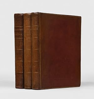
London: 1773-1785. 8 vols, 4to, and one vol. folio. Complete with 21 plates and charts in volume 1, 22 in volume 2 and 9 in volume 3, most of which are folding. 20th century half calf with linen paper-covered sides, backstrip tooled in gilt with green volume labels. Backstrips and board tips quite worn with splitting and some loss of calf, scattered foxing, signature "St. John" dated 1785 on the three title pages of the third voyage. Folio vol. boards detached, plates with some toning, foxing and marginal staining. Bookplates. § Complete set of Cook's Voyages: second (and best) edition of the first voyage, fourth edition of the second voyage, second edition of the third voyage. An internally attractive set in a worn binding. An excellent candidate for rebinding or enjoying in its current condition. The first voyage describes Cook's explorations of New Zealand, Australia, Tahiti, and other islands. The second voyage describes his southern voyages in search of a southern continent. The third is his north Pacific explorations of Alaska, the Northwest Coast, and Hawaii, where the great navigator met his death. Of equal importance as a text of exploration, a cartographic source for the numerous maps and charts included in the work, and a visual source of the engravings of fauna, flora, and inhabitants of the Pacific. In all, the entire set contains more than 200 maps and plates. Hill 782, 783. Howes C729a (3rd voyage). Holmes 5, 24, 47.
-
An Account of the Voyages undertaken by the order of his Present Majesty for Making Discoveries in the Southern Hemisphere, and, successively performed by Commodore Byron, Captain Wallis, Captain Carteret, and Captain Cook, In the Dolphin, the Swallow, and the Endeavour: Drawn up from the Journals which were kept by the several Commanders, and from the Papers of Joseph Bankes, Esq.
Verlag: London: Printed for A. Strahan, and T. Cadell, 1773, 1773
Anbieter: Peter Harrington. ABA/ ILAB., London, Vereinigtes Königreich
Verbandsmitglied: ABA ILAB PBFA
Bewertung:
Second edition of the official account of Cook's first voyage. This edition, printed in the same year as the first, is preferred "as it is complete with the chart of the Strait of Magellan and the List of Plates, and contains new information in the form of a new preface [by Hawkesworth]" (Parsons). The primary purpose of Cook's voyage in Endeavour was the observation of the transit of Venus from Tahiti, which would enable the distance between the earth and the sun to be calculated. Another mission was to search for "Terra Australis", the great hypothetical southern continent balancing the northern land mass. The first voyage was to result in the discovery of the Society Islands, the circumnavigation of New Zealand, and the charting of the eastern coast of Australia. "Hawkesworth, an eminent London author, was chosen by Lord Sandwich and commissioned by the Admiralty to prepare these narratives for publication. [He] was expected to add polish to the rough narratives of sea men, and to present the accounts in a style befitting the status of the voyages as official government expeditions, intended to embellish England's prestige as a maritime power" (Hill). Although the book was a huge success, fast becoming a best-seller, it was disastrous for its editor: "He was publicly attacked on three different counts: by the captains for tampering with the texts of their journals, by prudish readers for reprinting descriptions of the sexual freedoms of the South Sea islanders, and by devout churchmen for impiety in the general introduction to the work, in which Hawkesworth had rashly challenged the doctrine of providential intervention. He was devastated by this critical barrage, and it was thought to be the main cause of his death. The rumour recorded by Malone that he killed himself with an overdose of opium is uncorroborated, but Fanny Burney's conviction that his health was destroyed by the vilification he suffered seems well founded" (ODNB). Hill 782; Howgego I, C173; Parsons Collection 90; Sabin 30934. 3 volumes, quarto (290 x 235 mm). Contemporary diced calf, spines lettered direct, gilt single-fillet border to sides, spines and turn-ins, marbled endpapers, edges sprinkled blue. With 52 maps, charts and plates (most folding). Bindings expertly refurbished, a few marks to covers, scattered foxing, some offsetting (largely to or from plates), minor tear to plate 11 in vol. II. A very good copy.
-
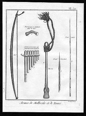
Armes & Mallicolo et de Tanna" - Tanna Island weapon Vanuatu Australia Kupferstich
Erscheinungsdatum: 1780
Anbieter: Antiquariat Steffen Völkel GmbH, Seubersdorf, Deutschland
Bewertung:
Kunst / Grafik / Poster
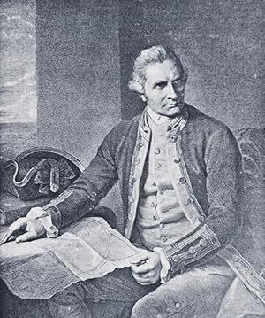
originalKupferstich von ca. 1780 - aus dem Atlas von James Cook's dritter Reise | original copper engraving from circa 1780 out of the atlas from James Cook's third voyage - Blattmasse ca.19 x25,5 cm - gut erhalten. - in very good condition. | | Cook's Third Voyage (1776-1779) During his first and second voyage, Cook circumnavigated the globe twice. He had sailed into the Antarctic extensively and had charted the coastlines from Newfoundland to New Zealand. Cook's third voyage was organized to seek a more efficient route from England to both southern and eastern Asia without entailing rounding the Cape of Good Hope.Since the beginning of the European expansion in the later fifteenth century, the search for a Passage more Northwest or even Northeast had been on the agenda of lots of northern European mariners and merchants. Incentive for the latest exploration for this specific route was England's growing interests in India, economical as well as colonial, in the late eighteenth century. Cook, who again was in command of this Resolution, was to approach the Northwest Passage from the Pacific. The Discovery, a second ship captained by Charles Clerke, was to accompany him. After leaving England separately, they regrouped at Cape Town and went from there to Tasmania, New Zealand and also Tahiti. They then continued to sail north and made landfall at the Christmas Island and Hawaiian Islands. Cook went further northward and charted the American west coast from northern California as far as the Bering Strait. When he returned to Hawaii for the winter, he was killed in an encounter with natives on February 14, 1779. Clerke took over the command of the expedition after Cook's death, but died several months later in August. Both ships returned to England in 1780, commanded by John Gore who had taken over the Discovery after Cook's death. The voyage had lasted a total of more than four years from start to finish. James Cook James Cook was born on 7 November 1728 in the Yorkshire village Marton. His father was a poor Scottish farm labourer, who had worked his way up to supervisor. James also began as a farm labourer and grocer's assistant. Soon he found employment in a Collier on the Baltic Sea. During the Seven Year's War in 1755, he volunteered for service and enlisted as an able seaman on the Eagle. He was promoted to master's mate under Captain Joseph Hamar within a month due to his outstanding ability. About four years later he had passed his master's examinations. James Cook, commanding his own ship, performed a very crucial charting and mapping of the Saint Lawrence River making the great amphibious assult upon Quebec City in 1759 possible. He was given command of the schooner Grenville in 1763 to survey the eastern coasts of Canada over a four year periode. These excellent charts were used up until the early 20th century. In 1768 James Cook was selected to lead an expedition to observe the transit of Venus as well as to explore new lands in the Pacific Ocean. In his first Pacific voyage, he rounded Cape Horn in the Endeavour reaching Tahiti on 3 June 1769. The transit of Venus was successfully observed after recovering a necessary scientific instrument stolen by the natives. The Endeavour then spent six months charting New Zealand. Next Cook explored and claimed possession of eastern Australia. The crew suffered an appalling 43% fatality rate after returning to England, on 12 June 1771, via New Guinea, Java and the Cape of Good Hope. James Cook thus became very concerned about crew health on subsequent voyages. He instituted compulsory dietary reforms that were copied by several other ship captains. The reason of Captain Cook's second Pacific Ocean voyage was to confirm the existence of a theorized Great Southern Continent. His ship the Resolution, which was accompanied by the Adventure, departed Plymouth on 13 July 1772 and again sailed around the Cape of Good Hope. Beset by ice, he unfortunately wasn't able to reach Antarctica. Although its existence was suspected, James Cook demonstrated, by traversing large areas of the south Pacific, that it would have to be a frigid wasteland, and not an economically productive addition to the British empire. With the incredible accuracy of only 3 miles James Cook charted many of the South Pacific Islands. This incredible accuracy was made possible by a new and highly accurate clock. Both ships returned to England on 29 July 1775, via Cape Horn. The experimental diets and close attention to cleanliness had a miraculous effect: out of a crew of 118, only one man was lost to disease. The many paintings by the artists were widely displayed and published as engravings, due to high public interest. Furthermore James Cook was awarded the Copley Gold Medal and elected as a fellow of the Royal Society. The third and last great voyage is significantly important to the history of the west coast of North America. Primarily Captain Cook and his men were searching for the Northwest Passage from the Pacific Ocean to the Atlantic Ocean. The ships both sailed around the Cape of Good Hope to reach the west coast of America in February of 1778. They continued north along the coast in haste to the Bering Sea and Bering Strait in an attempt to pass through the Arctic Ocean during the summer season. Foiled by ice, James Cook returned to Hawaii to prepare for another attempt at the Northwest Passage in the next season. A storm damaged the foremast of the Resolution soon after they had departed and forced them to return to Kealakekua Bay for repairs. Unfortunately, they had previously overstayed their welcome and relations became tense. The theft of a ship's cutter led Captain Cook to put ashore to demand the return of the boat. A fight broke out and James Cook was killed on 14 Feb 1779 by irked natives. Although his crew made another attempt at the Northwest Passage, they were unsuccessful. The expedition did identify the possibilities of trade with the coastal American na.
-
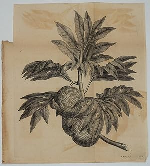
Breadfruit Engraving from Cook's first voyage
Verlag: Strahan & Cadell, London, 1773
Anbieter: Antipodean Books, Maps & Prints, ABAA, Garrison, NY, USA
Verbandsmitglied: ABAA ANZAAB ESA ILAB
Bewertung:
Copper engraving , folded, printed on watermarked paper . Impression size 12 ins x 14 ins. The work of John Frederick Miller (fl.1759-1794), the artist was employed by Joseph Banks to make drawings of some of the specimens collected on Cook's first voyage to the Pacific in the Endeavour. This image appeared as plate 11 in the official account of Cook's first voyage, An Account of the Voyages., London, 1773. In Chapter VIII on Otaheite (Tahiti) there is a long description of the discovery of the tree and the uses of its fruit: "it must be roasted before it is eaten, being fully divided into three or four parts.". William Bligh, who sailed with Cook on this first expedition, returned to Tahiti in 1787 as commander of the Bounty specifically to gather the breadfruit tree for cultivation in the West Indies. The condition is very good with the paper though folded being clean and crisp with a full margin. There is some light offsetting from the dark ink used in this obvious early pull of the plate.
-
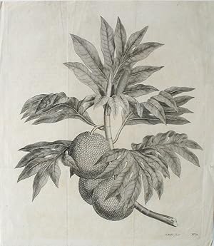
Breadfruit Engraving from Cook's first voyage. (A branch of the bread-fruit tree with the fruit)
Verlag: Strahan & Cadell, London, 1773
Anbieter: Antipodean Books, Maps & Prints, ABAA, Garrison, NY, USA
Verbandsmitglied: ABAA ANZAAB ESA ILAB
Bewertung:
Copper engraving of a branch of the bread fruit tree, with three fruit. The work of John Frederick Miller (fl.1759-1794), the artist was employed by Joseph Banks to make drawings of some of the specimens collected on Cook's first voyage to the Pacific in the Endeavour. This image appeared as plate 11 in the official account of Cook's first voyage, An Account of the Voyages., London, 1773. In Chapter VIII on Otaheite (Tahiti) there is a long description of the discovery of the tree and the uses of its fruit: "it must be roasted before it is eaten, being fully divided into three or four parts.". William Bligh, who sailed with Cook on this first expedition, returned to Tahiti in 1787 as commander of the Bounty specifically to gather the breadfruit tree for cultivation in the West Indies. The condition is very good with the paper, though originally folded, being clean and crisp with a full margin outside the impression mark. Short closed tear in right hand margin, not affecting printed area. Printed on watermarked paper. Impression size 12 x 14". Mitchell, 932, no. 11.
-

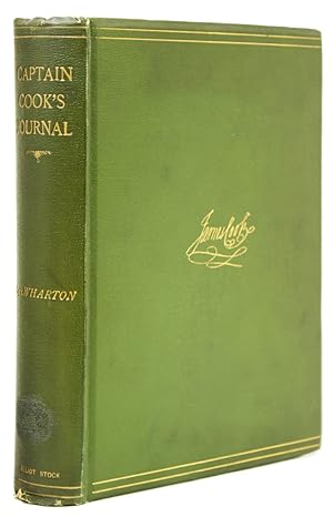
Captain Cook's Journal During His First Voyage Round the World Made in H.M. Bark "Endeavour" 1768-71 - A Literal Transcription of the Original MSS
Verlag: Elliot Stock, London, 1893
Buch Erstausgabe
Hardcover. Zustand: Good. First Edition. 400 pages. Index. Three maps in pocket at back. Three fold-out maps, the first of these "Modern Chart of South Pacific Ocean" has been cut in half with each half bound separately at page 32. A portion of this map is detached but present. Two fascimile pages of portions from Cook's original journal. Two plates. Frontispiece illustration of Cook. Sturdily rebound in forest green buckram with covers of the original boards affixed to new boards. Library call number gilt stamped to backstrip. Card pocket adhesive inside front board. Minor bit of peeling to new front free endpaper. Moderate overall wear.
-
Captain Cook's Journal During His First Voyage Round the World, Made in H.M. Bark Endeavour, 1768 71 : A Literal Transcription of the Original Mss
Verlag: Cambridge University Press, 2014
ISBN 10: 1108070507ISBN 13: 9781108070508
Buch
Taschenbuch. Zustand: Neu. Druck auf Anfrage Neuware - Printed after ordering - Transcribed from the original copies of James Cook's journals, this annotated 1893 publication includes a sketch of the explorer's life.
-
Captain Cook's Journal During his First Voyage Round the World Made in H. M. Bark "Endeavour" 1768-71. A Literal Transcription of the Original MSS
Verlag: Elliot Stock, London, 1893
Anbieter: ERIC CHAIM KLINE, BOOKSELLER (ABAA ILAB), Santa Monica, CA, USA
Bewertung:
Hardcover. Zustand: g. Quarto. lvi, 400pp. Original green cloth with gold border and signature of James Cook stamped in gold on front cover. Beveled edges, deckled page edges. Frontispiece of Cook in collotype protected by tissue guard. Ex-libris of Vice Admiral Sir Bouverie Francis Clark on inside of front board. Captivating account of Cook's first voyage of discovery to Australia and New Zealand from 1768-71. Illustrated with 7 fold-out maps, two facsimile letters and two full-page b/w reproductions of drawings. 3 of the maps rest in pocket at rear endpaper, as issued. Fold-out prospectus for "Captain Bligh's Second Voyage to the South Seas" by Ida Lee, Longmans, Green and Co. publishers, laid-in. Illustrated with one b/w reproduction of a painting showing Bligh. Age wear, staining and scuffing on binding. Age toning to outer edges of interior pages. Overall good+ condition. Complete with all plates and maps.
-
Captain Cook's Journal during His First Voyage Round the World Made in H.M. Bark "Endeavour" 1768-71. A Literal Transcription of the Original Mss
Verlag: Elliot Stock, London, 1893
Anbieter: James Cummins Bookseller, ABAA, New York, NY, USA
Bewertung:
First Wharton edition. First Wharton edition. Frontispiece portrait, 4 folding map and charts, 4 plates including two manuscript facsimiles, 3 folding maps in pocket at rear as issued. lvi, 400 pp. 4to. Beddie 683. Provenance: W.K. Bixby (bookplate); Missouri Historical Society (presentation stamp from Bixby and a few other discrete stamps; bookplate) Publisher's green cloth, spine lettered gilt, facsimile signature of Cook in gilt to upper cover. Some soiling to boards, hinges cracked, leaves toned, title page working loose, very good Frontispiece portrait, 4 folding map and charts, 4 plates including two manuscript facsimiles, 3 folding maps in pocket at rear as issued. lvi, 400 pp. 4to.
-
Captain Cook's Journal during his First Voyage round the World made in H.M. Bark "Endeavour" 1768-71. A Literal Transcription of the Original MSS. with Notes and Introduction, edited by Captain W.J.L. Wharton
Verlag: Libraries Board of South Australia, Adelaide, 1968
Anbieter: Adelaide Booksellers, Clarence Gardens, SA, Australien
Bewertung:
Hardback. Facsimile Edition. Small Quarto Size [approx 17.5cm x 24cm]. Very Good+ condition. Cream cloth boards, green title patch to spine. Australiana Facsimile Editions No 188. Black & white plates and facsimile documents (2) & fold-out maps and charts. An excellent copy. 400 pages. The first voyage of James Cook was a combined Royal Navy and Royal Society expedition to the south Pacific Ocean aboard HMS Endeavour, from 1768 to 1771. It was the first of three Pacific voyages of which Cook was the commander. The aims of this first expedition were to observe the 1769 transit of Venus across the Sun (3 - 4 June of that year), and to seek evidence of the postulated Terra Australis Incognita or "unknown southern land". Robust, professional packaging and tracking provided for all parcels.
-
Captain Cook's Journal during his First Voyage round the World, made in H.M. Bark Endeavour, 1768-71: A Literal Transcription of the Original MSS
Verlag: Cambridge University Press, 2014
ISBN 10: 1108070507ISBN 13: 9781108070508
Anbieter: Prior Books Ltd, Cheltenham, Vereinigtes Königreich
Verbandsmitglied: ABA ILAB PBFA
Bewertung:
Buch Erstausgabe
Paperback. Zustand: Like New. First Edition. Firm, square and tight, just showing a few very mild rubs. Hence a non-text page is stamped 'damaged'. Despite such this book looks and feels unread and is actually in nearly new condition. Thus the contents are crisp and fresh. Now offered for sale at a special bargain price.
-
Zustand: Gut. 1. 480 Seiten Gebrauchs- und Lagerspuren. Außen: Klebereste / Klebespuren. 24584659/3 Altersfreigabe FSK ab 0 Jahre Taschenbuch, Größe: 17.8 x 2.5 x 25.4 cm.
-
Carte d une partie du Grand Ocean.
Verlag: Artist: Cook/ Whitchurch James / Gulielmus ( - 1779 ) London; issued in: unknown; Cook/ Whitchurch James / Gulielmus ( 1728 - 1779 ) London; The first voyage of James Cook was a combined Royal Navy and Royal Society expedition to the south Pacific Ocean aboard HMS Endeavour from 1768 to 1771 It was the first of three Pacific voyages of which Cook was the commander The aims of this first expedition were to observe the 1769 transit of Venus across the Sun and to seek evidence of the postulated Terra Australis Incognita or "unknown southern land", 1728
Anbieter: Antique Sommer& Sapunaru KG, München, Deutschland
Bewertung:
Technic: Copper print; colorit: original colored; condition: Very good; size (in cm): 34 x 49,5; Map shows the east coast of Australia, with the Melanesian islands of New Guinea, Solomon Islands, New Caledonia and the Fiji Islands, as well as the Polynesian islands of Tonga and the Cook Islands. History: Oceania is the name for the island world of the Pacific north and east of the continent of Australia. In English, the term transoceania is also used. This term originated mainly for economic reasons in Australia and New Zealand and describes an area from northern Australia via Indonesia to the southern border of the Philippines and the far west of the Pacific islands. The term "South Sea" was coined in 1513 by Vasco Núńez de Balboa, when he had crossed the isthmus of Panama and called the sea (Pacific) in front of him Mar del sur (South Sea), as he was facing south from his location looked. Central island groups are the Society Islands (French Polynesia / Tahiti), the Samoa Archipelago and the Fiji Islands. In November 1520 Ferdinand Magellan, coming from the Strait of Magellan, reached the Pacific or the Pacific Ocean while circumnavigating the world. He called it Mar Pacifico (Portuguese and Spanish for Peaceful Seas) because the storms that had accompanied it until then subsided. Despite this name, there are also violent storms and cyclones in the Pacific, which are called typhoon or hurricane depending on the region. The spirit of discovery of the 16th century is decisive for numerous expeditions. The first focus is on exploring a western route across the Pacific to the rich trading centers of Asia. Later, mainly Spanish and Portuguese adventurers search for the hypothetical southern continent Terra Australis Incognita or hope to find legendary riches such as the mines of King Solomon. Due to inadequate navigation techniques, some of the island groups discovered, e.g. B. the Solomon Islands, cannot be found again and fell into oblivion. At the end of the 16th century, the Dutch began exploring Oceania too. In the 17th century there is still a lot undiscovered in the Pacific and, above all, the stories of those returning home from Paradise attract more and more sailors. The motivation to travel to new worlds is great, but goes hand in hand with the greed for the pristine natural resources of the new world. The church is meanwhile worried about the "mixing" with the heathen peoples, but is nevertheless interested in the salvation of the "savages". She reacts by publicly discrediting the fornication with the inhabitants and delegating missionaries to assist with the trips. In the 18th century there were less and less available on undiscovered islands, but circumnavigators like Louis Antoine de Bougainville, James Cook and others still found some unexplored areas. In addition, some of the discoveries made in the 16th century were forgotten again. Some now set about mapping the islands using modern means. In the 18th century, mapping continued and imperialism is beginning to take effect. Foreign island groups are increasingly being divided up among the great powers. The colonization of the South Pacific is becoming a race. Above all, Germans, British, French, Dutch and Americans fight over every island. At the end of the 19th century, the Spanish-American War led to a wild castling of the colonial territories.
-
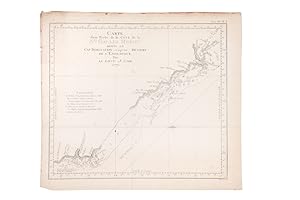
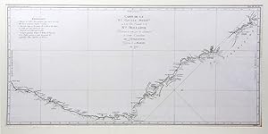
Carte d'une Partie de la Cote de la Nle. Galles Meridle. depuis le Cap Tribulation jusqu'au Detroit de L'Endeavour, par le Lieut. J.Cook
Verlag: Saillant et Nyon, Paris, 1774
Anbieter: Hordern House Rare Books, Surry Hills, NSW, Australien
Bewertung:
Engraved map, 295 x 335 mm.; original folds. French edition of Cook's chart, based on the original engraved chart in Hawkesworth's official account of the first voyage. This was the earliest charting of the coast of Queensland; it details the tracks and anchorages of the Endeavour as the expedition sailed north along the coastline in 1770, and commemorates one of the most memorable passages of Cook's first voyage. Far North Queensland was a difficult passage for the Endeavour: the ship ran aground on a shoal near the Hope Isles and required numerous repairs at Endeavour River. The expedition's naturalists, Joseph Banks, Herman Spöring and Daniel Solander, used the delay as an opportunity to collect Australian flora for European study. Cook's chart shows the exact spot of the reef where the ship went aground, as well as Endeavour River, where they beached the ship. The track to Cape York, including the passage through Providential Channel, is marked. The original manuscript chart from which this derives, now in the British Library, is reproduced in Historical Records of NSW (1893, plate 6). . In fine condition, with good margins.
-

First French printing of this well-known first map of the east coast of Australia. The map measures 13.25 inches by 12 inches. Matted. The entire piece measures 29 inches by 18 inches. One of the first detailed maps of this part of Australia's east coast and The Great Barrier Reef.
-
![Bild des Verkäufers für Carte d'une partie de la cote de la N[ouvel]le. Galles Merid[iona]le. depuis le Cap Tribulation jusqu'au détroit de l'Endeavour. zum Verkauf von Peter Harrington. ABA/ ILAB.](https://pictures.abebooks.com/inventory/md/md2717926128.jpg)
Carte d'une partie de la cote de la N[ouvel]le. Galles Merid[iona]le. depuis le Cap Tribulation jusqu'au détroit de l'Endeavour.
Verlag: [Paris: Saillant et Nyon, & Panckoucke, 1774], 1774
Anbieter: Peter Harrington. ABA/ ILAB., London, Vereinigtes Königreich
Verbandsmitglied: ABA ILAB PBFA
Bewertung:
An interesting chart of the north-eastern coast of Australia discovered by Cook in 1770, showing the Endeavour River and the Endeavour Strait, so named by Cook after his ship was careened and repaired on the banks of the river following grounding on a coral reef offshore, the site of present day Cooktown. From an early French edition of Cook's Voyages, vol. IV, plate 3. The Printed World III, item 165 Copper engraving. Later colour. Good condition, some offset and a little browning to left of central fold. Size: 33 x 29 cm. (13 x 11˝ inches).
-
Carte de la N. Galles merid. N. Hollande
Verlag: Artist: Cook/ Whitchurch James / Gulielmus ( - 1779 ) London; issued in: unknown; Cook/ Whitchurch James / Gulielmus ( 1728 - 1779 ) London; The first voyage of James Cook was a combined Royal Navy and Royal Society expedition to the south Pacific Ocean aboard HMS Endeavour from 1768 to 1771 It was the first of three Pacific voyages of which Cook was the commander The aims of this first expedition were to observe the 1769 transit of Venus across the Sun and to seek evidence of the postulated Terra Australis Incognita or "unknown southern land", 1728
Anbieter: Antique Sommer& Sapunaru KG, München, Deutschland
Bewertung:
Technic: Copper print; colorit: original colored; condition: Very good; size (in cm): 36 x 77; Map shows the southern coast of Australia. History: The first meeting between the native people and the British occurred on 29 April 1770 when Lieutenant James Cook landed at Botany Bay on the Kurnell Peninsula and encountered the Gweagal clan.He noted in his journal that they were confused and somewhat hostile towards the foreign visitors.Cook was on a mission of exploration and was not commissioned to start a settlement. He spent a short time collecting food and conducting scientific observations before continuing further north along the east coast of Australia and claiming the new land he had discovered for Britain. Prior to the arrival of the British there were 4,000 to 8,000 native people in Sydney from as many as 29 different clans. The earliest British settlers called the natives Eora people. ;Eora; is the term the indigenous population used to explain their origins upon first contact with the British. Its literal meaning is ;from this place; Sydney Cove from Port Jackson to Petersham was inhabited by the Cadigal clan.The principal language groups were Darug, Guringai, and Dharawal. The earliest Europeans to visit the area noted that the indigenous people were conducting activities such as camping and fishing, using trees for bark and food, collecting shells, and cooking fish.
-
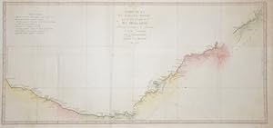
Carte de la Nlle. Galles Meridle. Ou de la Côte Orientale de la Nlle. Hollande Découverte et visitée par le Lieutenant J. Cook.
Verlag: Saillant et Nyon, Paris, 1774
Anbieter: Hordern House Rare Books, Surry Hills, NSW, Australien
Bewertung:
Zustand: In fine condition. Engraved map, 370 x 785 mm.; original folds; mounted. Perhaps Cook's most famous chart, here in its first French version, prepared for the French language edition of the official account of the Endeavour voyage. The magnificent sweep of the east coast of Australia from Point Hicks to Cape York is testament to Cook's extraordinary achievement on the first voyage. Cook's original manuscript chart is in the British Library. Two contemporary English engraved versions are recorded by David, the version published in Hawkesworth's official account and another, upright in shape, that appears only in Wales' Astronomical Observations (1788). This French version is not recorded by David. .
-
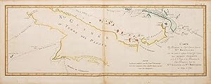
Carte des découvertes du Capne. Carteret dans la Nouvelle Bretagne avec une partie du passage du Capne Cook ŕ travers les Détroits Endeavour et de la Route et des Découvertes du Capne Dampierre dans la Nouvelle Guinée et la Nouvelle Bretagne en 1699 et 1700.
Verlag: 1774., 1774
Anbieter: Peter Harrington. ABA/ ILAB., London, Vereinigtes Königreich
Verbandsmitglied: ABA ILAB PBFA
Bewertung:
An interesting map with the Island of Papua New Guinea with the discoveries of Captain Carteret. From the French Edition of Cook's Voyages published 1774-1785. Engraved by Robert Benard. Sheet size: 260 x 648 mm Plate size: 235 x 625 mm Copper engraving. Hand colouring. Very good condition.
-

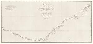
Chart of Part of the Coast of New South Wales from Cape Tribulation to Endeavour Strait
Verlag: London, 1770
Anbieter: Antipodean Books, Maps & Prints, ABAA, Garrison, NY, USA
Verbandsmitglied: ABAA ANZAAB ESA ILAB
Bewertung:
Copper engraved map, original folds, lt. browning on the center fold from the tab, 34x30 cm. The first printed map to concentrate on a section of Australia's east coast, from the lst edition of Cook's Voyages.

![Bild des Verkäufers für An Account of the Voyages undertaken by the order of His Present Majesty for making Discoveries in the Southern Hemisphere, and successively performed by Commodore Byron, Captain Wallis, Captain Carteret and Captain Cook, in the Dolphin, the Swallow, and the Endeavour. [Together with:] A Voyage towards the South Pole, and Round the World. Performed in His Majesty's Ships the Resolution and Adventure, in the years 1772, 1773, 1774 and 1775 [Together with:] A Voyage to the Pacific Ocean. Undertaken by the command of His Majesty, for making Discoveries in the Northern Hemisphere. zum Verkauf von John Windle Antiquarian Bookseller, ABAA](https://pictures.abebooks.com/inventory/md/md31218402351.jpg)