Gesamtpreis (1 Artikel Artikel):
Versandziel:

JOHN TALLIS (411 Ergebnisse)
Direkt zu den wichtigsten Suchergebnissen
Produktart
- Alle Produktarten
- Bücher (164)
- Magazine & Zeitschriften
- Comics
- Noten (1)
- Kunst, Grafik & Poster
- Fotografien
- Karten (246)
-
Manuskripte &
Papierantiquitäten
Zustand
Einband
Weitere Eigenschaften
Gratisversand
Land des Verkäufers
Verkäuferbewertung
-
The Horse: From Arabia to Royal Ascot
Verlag: British Museum Press 28/05/2012, 2012
ISBN 10: 071411183XISBN 13: 9780714111834
Buch
Zustand: Very Good. This book is in very good condition and will be shipped within 24 hours of ordering. The cover may have some limited signs of wear but the pages are clean, intact and the spine remains undamaged. This book has clearly been well maintained and looked after thus far. Money back guarantee if you are not satisfied. See all our books here, order more than 1 book and get discounted shipping. .
Mehr Angebote von anderen Verkäufern bei ZVAB
Gebraucht ab EUR 4,82
-
Forgotten Empire: The World of Ancient Persia
Verlag: University of California Press (edition ), 2005
ISBN 10: 0520247310ISBN 13: 9780520247314
Buch
Hardcover. Zustand: Very Good. Ship within 24hrs. Satisfaction 100% guaranteed. APO/FPO addresses supported.
-

38 x 26 cm Tallis, The British Isles, drawn & engraved by J. Rapkin, hrsg. ca. 1850, Stahlstich, koloriert, m. dek. Randkartusche, Format 38 x 26 cm, guter Zustand. Sprache: Deutsch Gewicht in Gramm: 550.
-

Zustand: Sehr gut. Zustand: Sehr gut - Gepflegter, sauberer Zustand. | Seiten: 424 | Sprache: Englisch.
-
Part of Russia in Asia and Independent Tartary. London, Printing and Publishing Company (1851). Grenzkolorierte Stahlstichkarte 36,5 x 27,5 cm. Die Karte hat drei gestochene Vignetten die Alltagsszenen zeigen "Tartars on a Journey", "The Bride Chase a Marriage Custom of the Tartars" and "The Tent". Mit floraler Umrandung.- Nr.43 aus "Illustrated Atlas" von Tallis.- Oben in der Mitte Kartentitel, unten links ein Maßstab (Miles). Ausserhalb des Kartenbildes unten links "The Illustrations by W. Bragg & Engraved by J. Rogers", unten rechts "The Map Drawn & Engraved by J. Rapkin".- Die Karte ist etwas gebräunt, in der Mitte einmal gefaltet, Falz hinterlegt, am oberen Rand ist ein kleiner Einriß (ca 1 cm) in der Falz.
-
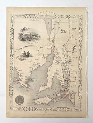
Antique Map - Part of South Australia
Verlag: London & New York: John Tallis & Company, 1851
Anbieter: Picture This (ABA, ILAB, IVPDA), Sunningdale, Vereinigtes Königreich
Verbandsmitglied: ABA ILAB PBFA
Bewertung:

Karte Erstausgabe
No Binding. Zustand: Fine. 1st Edition. Decorative steel engraved map of Adelaide, Flinders, Kangaroo Island and the Spencer Gulf (being part of the State of South Australia), surrounded by steel engraved vignette illustrations. Further enhanced with a decorative border design. Original outline hand colouring. Folio, no centrefold. Fine condition. Size: 37cm x 27.5cm.
-

History and Description of the Crystal Palace : And the Exhibition of the World S Industry in 1851
Verlag: Cambridge University Press, 2011
ISBN 10: 1108026729ISBN 13: 9781108026727
Buch
Taschenbuch. Zustand: Neu. Druck auf Anfrage Neuware - Printed after ordering - Tallis' book, published in 1852, gives a vibrant account of the Great Exhibition, a key event of the Victorian period.
-
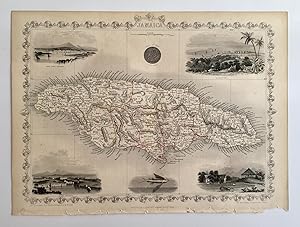
Antique Map - Jamaica
Verlag: London: Tallis, J. & F., 1851
Anbieter: Picture This (ABA, ILAB, IVPDA), Sunningdale, Vereinigtes Königreich
Verbandsmitglied: ABA ILAB PBFA
Bewertung:
Karte Erstausgabe
No Binding. Zustand: Fine. 1st Edition. Decorative steel engraved map of Jamaica, surrounded by steel engraved vignette illustrations. Further enhanced with a decorative border design. Folio, no centrefold. Fine condition. Size: 37.5cm x 27cm.
-
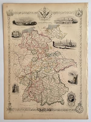
Antique Map - Germany
Verlag: London: Tallis, J. & F., 1851
Anbieter: Picture This (ABA, ILAB, IVPDA), Sunningdale, Vereinigtes Königreich
Verbandsmitglied: ABA ILAB PBFA
Bewertung:
Karte Erstausgabe
No Binding. Zustand: Near Fine. 1st Edition. Decorative steel engraved map of Germany, surrounded by steel engraved vignette illustrations. Further enhanced with a decorative border design. Folio, no centrefold. Fine condition, paper a little browned. Size: 27cm x 37.5cm.
-

Antique Map - Victoria or Port Philip (Australia)
Verlag: London: Tallis, J. & F., 1851
Anbieter: Picture This (ABA, ILAB, IVPDA), Sunningdale, Vereinigtes Königreich
Verbandsmitglied: ABA ILAB PBFA
Bewertung:
Karte Erstausgabe
No Binding. Zustand: Fine. 1st Edition. Decorative steel engraved map of the State of Victoria in Australia, surrounded by steel engraved vignette illustrations. Further enhanced with a decorative border design. Folio, no centrefold. Fine condition. Size: 37.5cm x 27cm.
-

The Illustrated Atlas and Modern History of the World.
Verlag: London & New York. c1851, 1851
Anbieter: Peter Harrington. ABA/ ILAB., London, Vereinigtes Königreich
Verbandsmitglied: ABA ILAB PBFA
Bewertung:
An extremely attractive and decorative title page, featuring peoples from the continents of the world, and a central vignette. Size: 370 x 270 mm. Steel engraving. Fine condition.
-
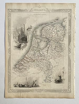
Antique Map - Holland
Verlag: London: Tallis, J. & F., 1851
Anbieter: Picture This (ABA, ILAB, IVPDA), Sunningdale, Vereinigtes Königreich
Verbandsmitglied: ABA ILAB PBFA
Bewertung:
Karte Erstausgabe
No Binding. Zustand: Near Fine. 1st Edition. Decorative steel engraved map of Holland, surrounded by steel engraved vignette illustrations. Further enhanced with a decorative border design. Folio, no centrefold. Near Fine condition. Size: 27cm x 37.5cm.
-
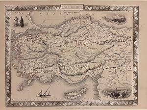
Asia Minor
Verlag: Tallis, John, London, 1857
Anbieter: Argosy Book Store, ABAA, ILAB, New York, NY, USA
Bewertung:
unbound. RAPKIN, John (illustrator). Map. Steel engraving with modern coloring. Image measures 10 1/4" x 12 3/4" This map of Turkey and the Middle East covers the regions between the Black Sea and Mediterranean, extending from Constantinople to Raqqa. The region is abundantly labeled with the names of cities, rivers, roads, and topographical features. The decorative vignettes, illustrated by H. Warren and engraved by J. H. Kernot, depict Olympus and Rhodes. An illustration of figures in traditional dress, and a ship are also featured. The map is surrounded by a beautiful floral border. It is in very good condition. John Tallis Jr. (1817-1876) was a London born bookseller who continued the prolific map publishing company started by his father. After a partnership with his brother, Tallis Jr. expanded the business to New York in 1849 as well as Boston, Cincinnati, Rochester, Philadelphia and Baltimore. He is remembered as one of the last decorative map makers, and this lovely map exemplifies his work.
-

History and Description of the Crystal Palace : And the Exhibition of the World S Industry in 1851
Verlag: Cambridge University Press, 2011
ISBN 10: 1108026710ISBN 13: 9781108026710
Buch
Taschenbuch. Zustand: Neu. Druck auf Anfrage Neuware - Printed after ordering - Tallis' book, published in 1852, gives a vibrant account of the Great Exhibition, a key event of the Victorian period.
-
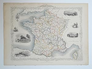
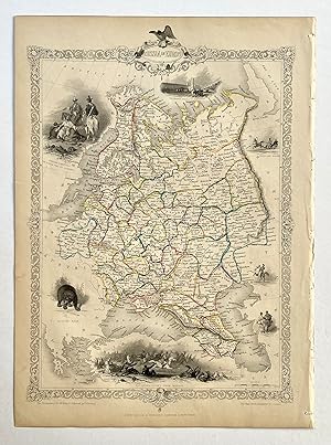
Antique Map - France
Verlag: London: Tallis, J. & F., 1851
Anbieter: Picture This (ABA, ILAB, IVPDA), Sunningdale, Vereinigtes Königreich
Verbandsmitglied: ABA ILAB PBFA
Bewertung:
Karte Erstausgabe
No Binding. Zustand: Fine. 1st Edition. Decorative steel engraved map of France, surrounded by steel engraved vignette illustrations. Further enhanced with a decorative border design. Folio, no centrefold. Fine condition. Size: 37.5cm x 27cm.
-
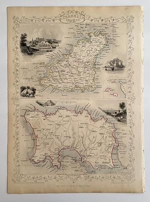
Antique Map - The Channel Islands (Jersey, Guernsey)
Verlag: London: Tallis, J. & F., 1851
Anbieter: Picture This (ABA, ILAB, IVPDA), Sunningdale, Vereinigtes Königreich
Verbandsmitglied: ABA ILAB PBFA
Bewertung:
Karte Erstausgabe
No Binding. Zustand: Fine. 1st Edition. Decorative steel engraved map of the Channel Islands, surrounded by steel engraved vignette illustrations. Further enhanced with a decorative border design. Folio, no centrefold. Fine condition. Size: 27cm x 37.5cm.
-

Antique Map - Cape Colony (South Africa)
Verlag: London: Tallis, J. & F., 1851
Anbieter: Picture This (ABA, ILAB, IVPDA), Sunningdale, Vereinigtes Königreich
Verbandsmitglied: ABA ILAB PBFA
Bewertung:
Karte Erstausgabe
No Binding. Zustand: Fine. 1st Edition. Decorative steel engraved map of Cape Colony (being the south western area of the country of South Africa), surrounded by steel engraved vignette illustrations. Further enhanced with a decorative border design. Folio, no centrefold. Fine condition. Size: 37.5cm x 27cm.
-

Antique Map - Northern Italy
Verlag: London: Tallis, J. & F., 1858
Anbieter: Picture This (ABA, ILAB, IVPDA), Sunningdale, Vereinigtes Königreich
Verbandsmitglied: ABA ILAB PBFA
Bewertung:
Karte Erstausgabe
No Binding. Zustand: Fine. 1st Edition. Decorative steel engraved map of Northern Italy, surrounded by steel engraved vignette illustrations. Further enhanced with a decorative border design. Original outline hand colour. Centrefold. Fine condition. Size: 27cm x 37.5cm.
-
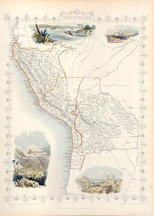
Peru & Bolivia.
Verlag: London & New York. c1851, 1851
Anbieter: Peter Harrington. ABA/ ILAB., London, Vereinigtes Königreich
Verbandsmitglied: ABA ILAB PBFA
Bewertung:
A beautiful and very decorative map of both Peru and Bolivia, engraved and published in the mid nineteenth century by the highly regarded firm of John Tallis & Co. Surrounding the map are a series of local vignettes, including the Peruvian capital city of Lima, and the famous Potosi, the site for silver for the Spaniards during the sixteenth century. The map is "framed" by an intricate border design. Size: 370 x 267 mm. Steel engraving with original outline colour. Good condition.
-
Antique Map - Russia in Europe
Verlag: London: John Tallis & Company, 1851
Anbieter: Picture This (ABA, ILAB, IVPDA), Sunningdale, Vereinigtes Königreich
Verbandsmitglied: ABA ILAB PBFA
Bewertung:
Karte Erstausgabe
No Binding. Zustand: Fine. 1st Edition. Decorative steel engraved map of European Russia, surrounded by steel engraved vignette illustrations. Further enhanced with a decorative border design. Folio, no centrefold. Original outline hand colouring. Fine condition. Size: 27cm x 37.5cm.
-

History and Description of the Crystal Palace : And the Exhibition of the World S Industry in 1851
Verlag: Cambridge University Press, 2011
ISBN 10: 1108026702ISBN 13: 9781108026703
Buch
Taschenbuch. Zustand: Neu. Druck auf Anfrage Neuware - Printed after ordering - Tallis' book, published in 1852, gives a vibrant account of the Great Exhibition, a key event of the Victorian period.
-
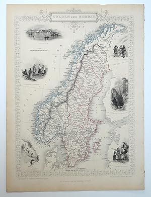
Antique Map - Sweden & Norway
Verlag: London: Tallis, J. & F., 1851
Anbieter: Picture This (ABA, ILAB, IVPDA), Sunningdale, Vereinigtes Königreich
Verbandsmitglied: ABA ILAB PBFA
Bewertung:
Karte Erstausgabe
No Binding. Zustand: Fine. 1st Edition. Decorative steel engraved map of Sweden and Norway, surrounded by steel engraved vignette illustrations. Further enhanced with a decorative border design. Folio, no centrefold. Fine condition. Size: 37.5cm x 27cm.
-
Antique Map - Japan & Corea
Verlag: London: Tallis, J. & F., 1851
Anbieter: Picture This (ABA, ILAB, IVPDA), Sunningdale, Vereinigtes Königreich
Verbandsmitglied: ABA ILAB PBFA
Bewertung:
Karte Erstausgabe
No Binding. Zustand: Very Good. 1st Edition. Decorative steel engraved map of Japan and the Korean peninsula, surrounded by steel engraved vignette illustrations. Further enhanced with a decorative border design. Folio, no centrefold. In Very Good condition. There is a small edge tear and a small area of paper thinning on the reverse which does not affect the front of the map. Will look excellent once framed. Size: 37.5cm x 27cm.
-

Antique Map - Western Australia - Swan River
Verlag: London: Tallis, J. & F., 1851
Anbieter: Picture This (ABA, ILAB, IVPDA), Sunningdale, Vereinigtes Königreich
Verbandsmitglied: ABA ILAB PBFA
Bewertung:
Karte Erstausgabe
No Binding. Zustand: Fine. 1st Edition. Decorative steel engraved map of Western Australia, surrounded by steel engraved vignette illustrations. Further enhanced with a decorative border design. Folio, no centrefold. Fine condition. Size: 27cm x 37.5cm.
-
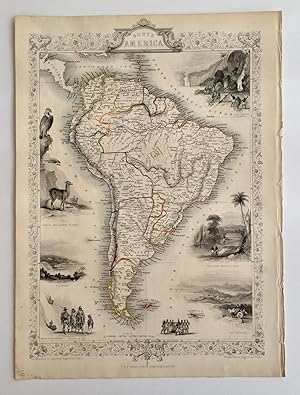
Antique Map - South America
Verlag: London: Tallis, J. & F., 1851
Anbieter: Picture This (ABA, ILAB, IVPDA), Sunningdale, Vereinigtes Königreich
Verbandsmitglied: ABA ILAB PBFA
Bewertung:
Karte Erstausgabe
No Binding. Zustand: Fine. 1st Edition. Decorative steel engraved map of South America, surrounded by steel engraved vignette illustrations. Further enhanced with a decorative border design. Folio, no centrefold. Fine condition. Size: 37.5cm x 27cm.
-

Antique Map - New South Wales (Australia)
Verlag: London & New York: John Tallis, 1851
Anbieter: Picture This (ABA, ILAB, IVPDA), Sunningdale, Vereinigtes Königreich
Verbandsmitglied: ABA ILAB PBFA
Bewertung:
Karte Erstausgabe
No Binding. Zustand: Fine. 1st Edition. Decorative steel engraved map of the state of New South Wales in Australia, surrounded by steel engraved vignette illustrations. Further enhanced with hand colouring, a decorative border design and gold diggings which are coloured in yellow. Folio, no centrefold. Fine condition. Size: 27cm x 37.5cm.
-
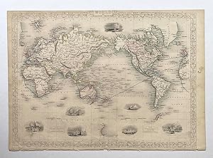
Antique Map - World on Mercator's Projection
Verlag: London: John Tallis & Company, 1851
Anbieter: Picture This (ABA, ILAB, IVPDA), Sunningdale, Vereinigtes Königreich
Verbandsmitglied: ABA ILAB PBFA
Bewertung:
Karte Erstausgabe
No Binding. Zustand: Good. 1st Edition. Decorative steel engraved map of the World on Mercator's Projection, surrounded by steel engraved vignette illustrations. Further enhanced with a decorative border design and the map shows the steam route around the world and to the colonies in blue. Folio, no centrefold. Original outline hand colouring. In Good+ condition, borders trimmed narrow at top and bottom and a small chip in the bottom margin among the publisher's details. Size: 26.5cm x 37.5cm.
-
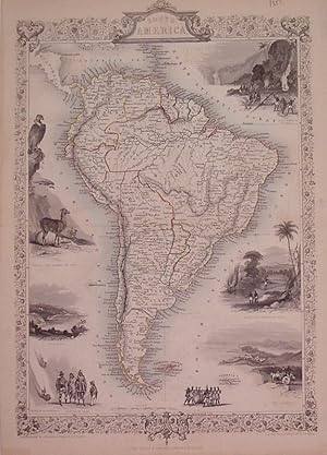
South America
Verlag: Tallis, John, London, 1851
Anbieter: Argosy Book Store, ABAA, ILAB, New York, NY, USA
Bewertung:
unbound. Zustand: very good. Rapkin, J. (illustrator). Map. Steel engraving with original hand outline. Image measures 14" x 9.5". Includes black and white vignettes, "Gold Washing in Brazil", "Brazilian Bridge of Ropes", "Rio Janeiro", "Natives of Chili", "Descent of the Cordilleras", "Valparaiso", "Condor and Llamas of Peru". Some discoloration along edges.
-

Venezuela, New Granada, Equador, and the Guayanas
Verlag: Tallis, John, London, 1851
Anbieter: Argosy Book Store, ABAA, ILAB, New York, NY, USA
Bewertung:
unbound. Zustand: very good. Rapkin, J. (illustrator). Map. Steel engraving with original hand outline. Image measures 10" x 13". Detailed map of N South America with part of the Caribbean Sea. Four Tallis vignette include: "Fall of the Bagota", "Paramaribo" and "Chimborazo" and some tropical birds in flight. Small closed tears lower right margin but not affecting the image, otherwise in good condition. John Tallis Jr. (1817-1876) was a London born bookseller who continued the prolific map publishing company started by his father. After a partnership with his brother, Tallis Jr. expanded the business to New York in 1849 as well as Boston, Cincinnati, Rochester, Philadelphia and Baltimore. He is remembered as one of the last decorative map makers, and this lovely map exemplifies his work.
-
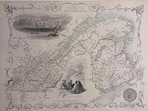
East Canada and New Brunswick
Verlag: J. Rapkin, London
Anbieter: Argosy Book Store, ABAA, ILAB, New York, NY, USA
Bewertung:
unbound. Map. Steel engraving with original hand coloring. Image measures 10.5" x 12.75". In good condition, with no center fold or crease as is common with this map. This map of Eastern Canada and New Brunswick shows the span of the St. Lawrence river from Gaspe to Montreal. Decorative vignettes show a view of Quebec from the river, and a grouping of North American Indians. The map is from R. Montgomery's "Illustrated Atlas and Modern History of the World." John Tallis Jr. (1817-1876) was a London born bookseller who continued the prolific map publishing company started by his father. After a partnership with his brother, Tallis Jr. expanded the business to New York in 1849 as well as Boston, Cincinnati, Rochester, Philadelphia and Baltimore. He is remembered as one of the last decorative map makers, and this lovely map of British America exemplifies his work.