Gesamtpreis (1 Artikel Artikel):
Versandziel:

HULST, GERARD VAN (5 Ergebnisse)
Direkt zu den wichtigsten Suchergebnissen
Produktart
- Alle Produktarten
- Bücher (4)
- Magazine & Zeitschriften
- Comics
- Noten
- Kunst, Grafik & Poster
- Fotografien
- Karten (1)
-
Manuskripte &
Papierantiquitäten
Zustand
- Alle
- Neu
- Antiquarisch/Gebraucht
Einband
Weitere Eigenschaften
- Erstausgabe
- Signiert
- Schutzumschlag (1)
- Angebotsfoto (4)
Gratisversand
Land des Verkäufers
Verkäuferbewertung
-
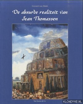
De absurde realiteit van Jean Thomassen
Verlag: Van Soeren & Co, Amsterdam, 1995
ISBN 10: 9068810553ISBN 13: 9789068810554
Buch
Zustand: Good.
-

4to. 128 S. Mit zahlr. Farbabb. Opp. mit OU. 1,100 gr.
-

Sing mit mir - neue Kinderlieder
Verlag: Agentur des Rauhen Hauses, Hamburg, 1976
ISBN 10: 3760001637ISBN 13: 9783760001630
Buch
31 Seiten Format 15 x 21 cm Heft,mit Noten,Illustrationen,leichte Gebrauchs- / Lagerspuren,sonst: in sehr guten, sauberen Zustand, "Die AGB und Widerrufsbelehrung finden Sie unter "Anbieter- & Zahlungsinformationen"."Alle Preise inkl. MwSt.".
-
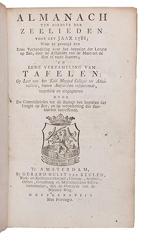
Almanach ten dienste der zeelieden voor het jaar 1788.Including:(2) Over het bepalen der lengte op zee door de afstanden van de maan tot de zon, of vaste sterren, .(3) Van tafelen, ten dienste der zeelieden, en voor al ter bevordering van het bepaalen der lengte op zee, door de afstanden van de maan tot de zon, of de vaste sterren; .Amsterdam, Gerard Hulst van Keulen, 1787-1788. 3 parts in 1 volume. 8vo. With three title-pages with woodcut printer's device, mathematical figures in the text, letterpress tables, and 4 large printed folding tables. Contemporary half vellum.
Anbieter: ASHER Rare Books, T Goy Houten, Niederlande
Bewertung:

XXX, 108, 87, [1]; XXIII, 136; [4], 30, [2], 60 pp.First edition of an almanac for the use of seamen, in three parts, published by order of the board of the Amsterdam Admiralty by the Committee for the establishment of longitude at sea and the improvement of nautical charts, in which committee Van Swinden played a leading role. The almanac is based on the English Nautical almanac and includes everything that can be of use to seamen, including a separate part on the calculation of longitude at sea and a part with letterpress tables necessary for the calculations. Although John Harrison had already demonstrated the accuracy of his chronometer in the 1760s they were still not in widespread use and the present works calculate longitude from very precise measurements of the position of the moon.In very good condition, only slightly browned around the margins. Binding worn along the extremities, sides chafed but otherwise good.l Bierens de Haan, 4789 (1), 4791 (2), 4793 (3); C.A. Davids, Zeewezen en wetenschap, pp. 188-190; Poggendorf II, col. 1058.
-
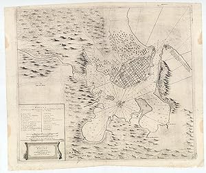
HAVANA, CUBA: De Stad en Haven van Havana op't E˙land Cuba met alle Desselfs Droogtens en Dieptens.
Verlag: Amsterdam: Johannes van Keulen [Gerard Hulst van Keulen, circa ]., 1780
Anbieter: Antiquariat Dasa Pahor GbR, München, Deutschland
Bewertung:

Karte
Copper engraving, contemporary guard mounted to centrefold verso (Very Good, clean and attractive, just some stains in blank margins), 53 x 65 cm (21 x 25.5 inches). One of the rarest and most attractive of the great historical sea charts of Havana Harbour, and one which grants a fine rendering of the cityscape of what was then the New World s most sophisticated metropolis; first published in the mid-18th century by the eminent Amsterdam cartographer Johannes Van Keulen II, but here with the plate re-employed around 1780 by his son, Gerard Hulst van Keulen, the last major principal of the legendary Van Keulen publishing dynasty. - This very rare chart of Havana Harbour was first issued by Johannes van Keulen, the scion of the legendary Amsterdam chairmaking dynasty, around 1750, and was reissued (without changes to the plate) about three decades later by his son, Gerard Hulst van Keulen. One of the most attractive of historical charts of the subject, it provides a fine rendering of the city of Havana proper. Havana s stellar natural harbour is shown to expand into a great basin beyond its narrow mouth, which connect it to the Straits of Florida. The waters feature numerous bathymetric soundings, while the great walled city occupies the peninsula to the northwest of the port. Havana, founded in 1513, had for over two centuries been the great marshalling point for the Flotas, the annual fleets of Spanish galleons that carried vast quantities of silver and gold from South America and Mexico to Spain. This role, plus Cuba s immensely lucrative sugar-slave economy, had made Havana one of the wealthiest and arguably the most culturally sophisticated city in the New World. Its streets and great plazas were lined with immensely grand and elaborately decorative buildings that would have held pride of place in any European capital. The city of Havana is shown to be surrounded by its old walls and additionally defended by the immense fort of the Castillo de El Morro, at the western side of the moth of the harbour, while across is its sister bastion, the Castello de La Punta, while the Castello de La Fuerza protects Havana s quayside. Within the city, the key, in the lower left, employs letters to identify 22 sites, labelled (A-Z) with the first 16 entries on the list (A-Q) noting Havana s many grand ecclesiastical edifices, including A. Cathedral, as well as convents / monasteries and parish churches. Secular sites include the R. Audit Office (where gold and silver was inventoried!); S. St. Elmo s Redoubt; T. Infantry Barracks; X. Main City Gate; and Z. Abattoir. The surrounding countryside assumes a bucolic appearance, with rolling hills, forests and arroyos, punctuated by roads and the odd rural church. SEE OUR WEB PAGE FOR A LONGER DESCRIPTION.