Gesamtpreis (1 Artikel Artikel):
Versandziel:

GILL, MACDONALD (10 Ergebnisse)
Direkt zu den wichtigsten Suchergebnissen
Produktart
- Alle Produktarten
- Bücher (6)
- Magazine & Zeitschriften
- Comics
- Noten
- Kunst, Grafik & Poster
- Fotografien
- Karten (4)
-
Manuskripte &
Papierantiquitäten
Zustand
Einband
- alle Einbände
- Hardcover
- Softcover (4)
Weitere Eigenschaften
- Erstausgabe (1)
- Signiert
- Schutzumschlag
- Angebotsfoto (8)
Land des Verkäufers
Verkäuferbewertung
-
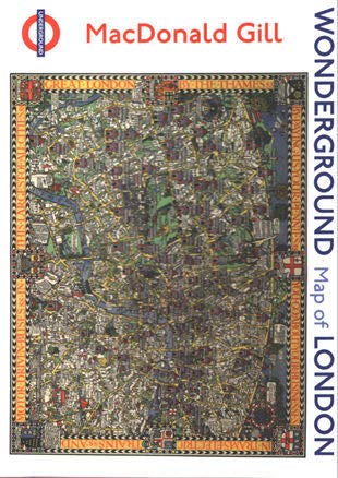
Wonderground: Map of London - Contains 20 Cards (5 Each of 4 Designs) & 20 Envelopes. (Boxed)
Verlag: Pomegranate.
ISBN 10: 0764974459ISBN 13: 9780764974458
Anbieter: Powell's Bookstores Chicago, ABAA, Chicago, IL, USA
Bewertung:

Buch
Zustand: Used - Like New. Fine. Paperback. 2016. This is an imported edition.
-
Zustand: VeryGood. Most items will be dispatched the same or the next working day.
-
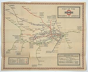
Map of the Underground Railways of London.
Verlag: LondonWaterlow & Sons Limited November 1 .*, 1922
Anbieter: Robert Frew Ltd. ABA ILAB, London, Vereinigtes Königreich
Verbandsmitglied: ABA ILAB PBFA
Bewertung:
Karte
Original colour-printed folding map of the London Underground (37 x 45.5 cm) designed by MacDonald Gill representing each of the lines with a different colour and including the names of each of the stations, with the British Empire Exhibition Stations (at Wembley) highlighted in red. The underground lines represented here are more flowing than those in Harry Beck's later design for the tube map. In the top right there is a key to indicate which lines the colours relate to. The cover side lists places of interest and includes two additional plans showing theatres and connections with main line termini. Some light toning and minimal nicks to some folds, upper cover with some light spotting and ink marks, generally a very good copy of this scarce Gill map. The revival of the decorative map in the 20th century is often attributed to MacDonald 'Max' Gill, the younger brother of typographer Eric Gill. Although his painted maps would decorate the homes of wealthy landowners, prominent public buildings and Cunard liners, it was Gill's poster maps that brought him fame. In the first half of the 20th century the golden age for poster art his poster maps spearheaded major publicity campaigns for such institutions as the London Underground and the Empire Marketing Board (EMB). However, Gill was also an architect, letterer, mural painter and commercial artist (British Library). *Curiously dated November 1922 despite the British Empire Exhibition not being held until the 23rd of April to the 1st of November 1924-1925. There was however a tour headed by Major Ernest Belcher in 1922 to promote participation in the Exhibition, with Agatha Christie and her husband among the participants. We are aware of a very similar map designed by Gill which is dated 1923; perhaps this is an early promotional proof copy (?) for the forthcoming exhibition. We are unable to locate any other copies dated 1922.
-
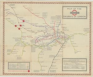
Underground: What to See and How to Travel: Map of the Electric Railways of London. Issued Free. Folding map
Verlag: Waterlow & Sons Ltd, London, 1923
Anbieter: Antipodean Books, Maps & Prints, ABAA, Garrison, NY, USA
Verbandsmitglied: ABAA ANZAAB ESA ILAB
Bewertung:

Map, folding. Zustand: Good + overall. Second printing. An early version of the Underground map, by map designer MacDonald Gill [1884-1947] one of the founders of the new genre of pictorial mapping. The print code printed at the lower edge reads 1/1/23 or January 1st 1923. Each railway line is printed in a different color and there is a brown decorative border around the outer edge. Side one has the Key map showing main line railway, connections with main line termini. Side two, verso, has the Theatre plan and text. Printed for Electric Railway House, Westminster, S.W. 1. Printed as a folding map with the sheet size: 17 ľ x 14 1/2". Original folds with toning to the exposed sides (when folded). Previous owner signature on front wrapper. There are some short closed tears along some of the fold lines, overall in good condition.
-
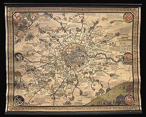
The Country Bus Services Map.
Verlag: Waterlow & Sons, 1928]., [London,, 1928
Anbieter: Daniel Crouch Rare Books Ltd, London, Vereinigtes Königreich
Verbandsmitglied: ABA ILAB PBFA
Bewertung:

Karte
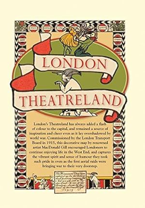
Gill's bus map Chromolithograph map, mounted on linen on original rollers. Gill's rare poster map advertising the bus services from London to the Home Counties. The text around the map reads: "Far flung are our bus routes, they here are displayed. They mean nought to you! We are not dismayed. There are thousands of citizens who love the fresh air. Hundreds not misers will pay debonair. But they must remember to clear their waste paper. Dry bottles and what not at the end of their caper. So there!" Leslie MacDonald Gill (1884- 1947) was a noted graphic designer, cartographer, artist and architect. Born in Brighton, he was the younger brother of Eric Gill, one of the leading figures of the Arts and Crafts movement. In 1914 his "Wonderground Map", commissioned by Frank Pick, and hung at every station, helped to save the London Underground by presenting an accurate map which also had a humorous side in cartoon style. Produced in poster form, it was also made available for sale to members of the public and proved to be very popular. Elder brother Eric, who at that time was engaged in a commission for Westminster Cathedral, was included at the bottom of the map. He also designed of the standard upper case lettering used on headstones and war memorials by the Imperial War Graves Commission. But it is perhaps his illustrated maps for which he is most well known. These maps have featured in a series of exhibitions including Magnificent Maps exhibition in 2010 at the British Library, an exhibition MacDonald Gill, Out of the Shadows in 2011 at the University of Brighton and at the Mind the Map exhibition in 2012 at the London Transport Museum.
-
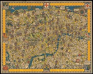
The Wonderground Map of London Town Drawn by MacDonald Gill.
Verlag: Printed & Published by The Westminster Press, 11 Henrietta Street, Covent Garden, W.C.,, 1914
Anbieter: Daniel Crouch Rare Books Ltd, London, Vereinigtes Königreich
Verbandsmitglied: ABA ILAB PBFA
Bewertung:
No Binding. Zustand: Fine. Gill's humorous map of London and its Underground Stations Chromolithograph plan, minor repairs to corners and old folds strengthened. Gills humorous map of London and its underground stations."During his lifetime MacDonald Gill?Äôs acclaim rested on artistic endeavours of amazing diversity; one area of particular celebrity involved the pictorial maps he designed for both governmental and private organisations. The first of these maps was commissioned in 1913 as a poster for use in the stations of the privately held Underground Electric Railways Company. The enthusiasm of the public for this poster was such that a smaller version, titled the Wonderground Map of London Town, was published for sale the following year. On the occasion of Gill?Äôs death in 1947 the Journal of the Royal Institute of British Architects referred to this Wonderground Map as ?Äúa cartographical masterpiece.?Äů Its groundbreaking design, with emphasis on visual and verbal whimsy and bold primary colors, awakened a generation of cartographers to the imaginative possibilities of pictorial mapmaking." (Elizabeth Burden)The text around the map reads:"The Heart of Britain's Empire Here is Spread Out for Your View. It Shows You Many Stations & Bus Routes Not a Few. You Have Not the Time to Admire it All? Why not Take a Map Home to Pin on Your Wall." 750 by 940mm (29.5 by 37 inches). Burden, Elizabeth, "MacDonald Gill's Wonderground Map of 1913 and Its Influence on Twentieth Century Mapmaking", July 22, 2011.
-
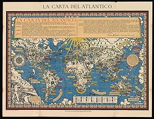
La Carta del Atlantico.
Verlag: London,, 1943
Anbieter: Daniel Crouch Rare Books Ltd, London, Vereinigtes Königreich
Verbandsmitglied: ABA ILAB PBFA
Bewertung:
Karte
Rare Spanish edition of Gill's celebrated Time and Tide Map Chromolithograph map, some minor strengthening to folds. Gill was commissioned by the British Time & Tide magazine (1920-1986) following the World War Two Atlantic Charter agreement between the US President Franklin D. Roosevelt and UK Prime Minister Winston Churchill "for a better future for the world" 14 August 1941 - La Carta del Atlantico. Stunning design featuring detailed colourful pictorial depictions of agriculture and food production, industrial raw materials and traditional life around the world including images of people, animals, trees, cattle, ships at sea, planes flying overhead and markers with a symbol box listing the locations of metals, wine, crops, petroleum, tobacco, sugar, rubber, silk, coffee, fruit, precious stones etc., surrounded by clouds on the sides and the sun shining down from The Atlantic Charter in the text box at the top with a black and white image below of an industrial metal worker destroying tanks and machinery and a farming family ploughing a field with horses, the cities, countries, continents and quotes in banners with a seal and a compass point on both sides, all framed within a decorative border. Leslie MacDonald Gill (1884- 1947) was a note graphic designer, cartographer, artist and architect. Born in Brighton, he was the younger brother of Eric Gill, one of the leading figures of the Arts and Crafts movement. In 1914 his "Wonderground Map", commissioned by Frank Pick, and hung at every station, helped to save the London Underground by presenting an accurate map which also had a humorous side in cartoon style. Produced in poster form, it was also made available for sale to members of the public and proved to be very popular. Elder brother Eric, who at that time was engaged in a commission for Westminster Cathedral, was included at the bottom of the map. He also designed of the standard upper case lettering used on headstones and war memorials by the Imperial War Graves Commission. But it is perhaps his illustrated maps for which he is most well known. These maps have featured in a series of exhibitions including Magnificent Maps exhibition in 2010 at the British Library, an exhibition MacDonald Gill, Out of the Shadows in 2011 at the University of Brighton and at the Mind the Map exhibition in 2012 at the London Transport Museum.
-
Zustand: Neuf.
-
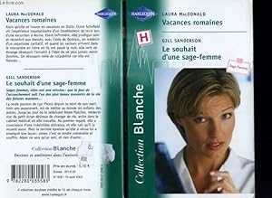
VACANCES ROMAINES SUIVI DE : LE SOUHAIT D'UNE SAGE FEMME (MEDITERRANEAN RESCUETHE MIDWIFE'S BABY WISH)
Verlag: COLLECTION HARLEQUIN SERIE BLANCHE N° 658, 2003
ISBN 10: 2280035588ISBN 13: 9782280035583
Buch
Couverture souple. Zustand: bon. RO90115173: 2003. In-12. Broché. Bon état, Couv. convenable, Dos satisfaisant, Intérieur frais. 310 pages. Numéro double. . . . Classification Dewey : 820-Littératures anglaise et anglo-saxonne.
-
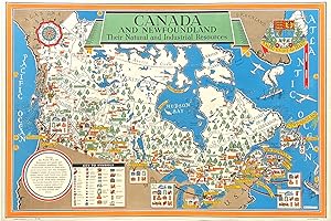
Original Vintage Pictorial Map - Canada and Newfoundland. Their Natural and Industrial Resources
Erscheinungsdatum: 1942
Anbieter: Picture This (ABA, ILAB, IVPDA), Sunningdale, Vereinigtes Königreich
Verbandsmitglied: ABA ILAB PBFA
Bewertung:
Karte Erstausgabe
No Binding. Zustand: Fine. 1st Edition. Original Vintage Pictorial Map, Lithograph printing, 1942. 75cm x 51cm. Condition Grade: A, Excellent. Linenbacked. One of a series of maps designed by MacDonald Gill during WW2 promoting products and resources of key overseas and colonial territories.