Gesamtpreis (1 Artikel Artikel):
Versandziel:

Jean de Beaurain (51 Ergebnisse)
Direkt zu den wichtigsten Suchergebnissen
Produktart
- Alle Produktarten
- Bücher (23)
- Magazine & Zeitschriften
- Comics
- Noten
- Kunst, Grafik & Poster (19)
- Fotografien
- Karten (9)
-
Manuskripte &
Papierantiquitäten
Zustand
Einband
Weitere Eigenschaften
- Erstausgabe
- Signiert
- Schutzumschlag
- Angebotsfoto (46)
Gratisversand
Land des Verkäufers
Verkäuferbewertung
-

Histoire Militaire Du Duc de Luxembourg. Tome 1 (Ed.1756-1758)
Verlag: HACHETTE LIVRE, 2012
ISBN 10: 2012671535ISBN 13: 9782012671539
Buch
Zustand: New.
-

Histoire Militaire Du Duc de Luxembourg. Tome 4 (Ed.1756-1758)
Verlag: HACHETTE LIVRE, 2012
ISBN 10: 2012671551ISBN 13: 9782012671553
Buch
Zustand: New.
-

Histoire Militaire Du Duc de Luxembourg. Tome 3 (Ed.1756-1758)
Verlag: HACHETTE LIVRE, 2012
ISBN 10: 2012671543ISBN 13: 9782012671546
Buch
Zustand: New.
-

Histoire Militaire De Flandres, Depuis L\ année 1690 Jusqu\ en 1694 Inclusivement, Qui Comprend Le Détail Des Marches, Campemens, Batailles, Siéges Et M
Verlag: WENTWORTH PR, 2018
ISBN 10: 0274936097ISBN 13: 9780274936090
Buch
Kartoniert / Broschiert. Zustand: New.
-

Histoire Militaire de Flandre, Inclusivement Par Le Chevalier de Beaurain. Tome 2
Verlag: HACHETTE LIVRE, 2017
ISBN 10: 2013019785ISBN 13: 9782013019781
Buch
Zustand: New.
-
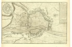
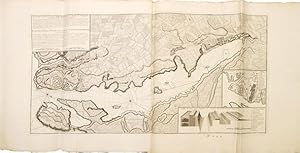
Plan de Maestricht.
Erscheinungsdatum: 1760
Anbieter: Altea Antique Maps, London, Vereinigtes Königreich
Verbandsmitglied: ABA ILAB PBFA
Bewertung:

Karte
Paris, c.1760. 240 x 370mm. Trimmed to printed border on left. A detailed plan of the defences of Maastricht by Jean de Beaurain (1696-1771), geographer to Louis XV. Engraved by Charles Inselin and first published in 1740, the map was originally designed to illustrate a history of the campaigns of Louis XIV; this example has been updated to be more contemporary, with the 18th century Fort St Pieter top left.
-
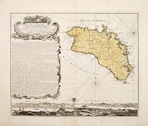
Carte Topographique de L'Isle Minorque, Dediee et Presentee au Roy, Par le Chevalier de Beaurain, Geographe ord. du Roy. et communiquée au Public par les Heritiers de Homan en l'an 1757.
Verlag: Nuremberg: Homann Heirs 1757, 1757
Anbieter: Peter Harrington. ABA/ ILAB., London, Vereinigtes Königreich
Verbandsmitglied: ABA ILAB PBFA
Bewertung:
An attractive map depicting the beautiful Spanish Balearic island of Minorca (Menorca), decorated with a cartouche on top left margin. With a large block of historical text underneath describing the island, embellished with an ornate, scrolled border; There are two delightful panoramic views of the islands capital of Mahon and that of Fort St. Philippe along the lower margin. The island of Minorca is located on right side with relief of the landscape shown pictorially. An attractive map of a popular and desirable island further enhanced by being in original colour. Upon the death of Johann Christoph Homann in 1730, the business immediately became known as Homann Heirs. Size: 530 x 420 mm. Copper engraving. Original colour. Good condition with wide margins, a small neatly mended tear on bottom margin does not affect image.
-
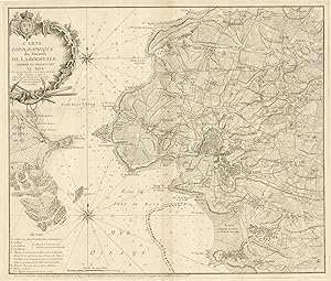
Carte Topographique des Environs de La Rochelle.
Erscheinungsdatum: 1758
Anbieter: Altea Antique Maps, London, Vereinigtes Königreich
Verbandsmitglied: ABA ILAB PBFA
Bewertung:
Karte
No Binding. Zustand: Very Good. Paris, Jean Chevalier de Beaurain, 1758. 510 x 605mm. A very detailed chart of La Rochelle, also mapping the land in the environs. La Rochelle importance as a sea port made it a possible target for the British during the Seven Years' War (1756-63), and Beaurain was commissioned to map the area to aid its defence.
-
Histoire de la campagne du prince de Condé, en Flandre, en 1674. précédée d'un tableau historique de la guerre de Hollande jusqu'a cette époque.
Verlag: Jombert, Paris, 1774
Buch
Zustand: Gut. XIV, 63, 216 S, 4 Blatt. Ill. With two engraved title pages, 2 pierced portraits, 40 (instead of) 41; 32 double sheet sizes, 8 folded), copper plates and maps, as well as some engraved initials and vignettes. Graesse I, 317; Cohen-R. 128: --- ----------------------------- With a large overview map of the Catholic Netherlands and the surrounding area Map of the theaters of war, all with color-coded formation of troops. There are also border-colored maps of the Netherlands, the Middle Rhine and Burgundy. A view of Argenteau Castle and floor plan of the fortress Navagne. In addition, a three-color "ground plan of the Maison de Force de Ghent" is included. Sometimes slightly browned, especially the edges a little finger- and water-stained, and sometimes slightly spotted or soiled. The last leaves wrinkled a bit and with a brown water spot down in the bow. Some marginal tears and tears, the map of Seneffe with glued and missing in the picture. deu MIG-35-03A|Lager 19|7045AB Sprache: Deutsch Gewicht in Gramm: 444 43 x 27,5 cm. Modern half leather binding using the old back and front.
-

Plan de la Ville et du Port Mahon et du Fort St. Philippe Tel qu'il étoit fortifié en 1706 par les Espagnols.
Verlag: Le Chevalier de Beaurain Géographe Ordinaire, [c1756]., Paris,, 1756
Anbieter: Daniel Crouch Rare Books Ltd, London, Vereinigtes Königreich
Verbandsmitglied: ABA ILAB PBFA
Bewertung:

Karte
Map of Mahon and Fort St Philip Engraved map, dissected and laid on linen. This map showing a plan of the city of Mahón on Menorca, near the Catalonian coast, records the area at a key point in its history. The island officially became a British possession in 1713, during the War of Spanish Succession, and subsequently the capital was transferred to Mahón, where the British Governor resided. Around the time this map was produced, the city became involved in the Seven Years' War, with the Siege of Fort St Philip taking place in 1756. Two insets in the lower right corner show this fort, labelled with its French and Spanish names and viewed from above and in profile. The Italian architect Gianbattista Calvi had constructed the fortress under the orders of King Felipe II in 1554, and it had been fortified by the Spanish in 1706. 50 years later, it was captured by the French army, but only remained under French control until the end of the year, when it was transferred back to the British. In 1782, the Spanish retook the fort and the island, and the former was demolished. Port Mahón played an important role throughout these various conflicts, and as one of the world's finest natural harbours, it was carefully guarded as a strategic stronghold. The map encompasses the surrounding rural regions to the North, and the detailed coastline around the port. The plans of the fortress and city suggest that this map would have been put to use as a military tool; made by the royal geographer of France, it is possible that the Louis XV commission the map in the immediate aftermath of his victory. In the upper left corner, a key identifies the various buildings, roads and islands featured on the image. The key is written in both French and Spanish, yet further evidence of how the island was constantly changing hands throughout the eighteenth century. Black, 'Minorca', (The Encyclopćdia Britannica Volume 15. 8th edition., 1858); Coad, 'Support for the Fleet: architecture and engineering of the Royal Navy's bases, 1700-1914', (Swindon: English Heritage, 2013).
-

(Feldzüge des Marschalls von Luxemburg, oder Militärgeschichte von Flandern in den Jahren 1690-1694). Nur die 4 Kartentheile.
(Potsdam, 1783-85). 4to. (36 x 29 cm.). 4 portfolios in hcalf with ties. Gilt titlelabels on upper boards. Containing maps to all 4 campaigns. 64 (of 70 ?) folded maps in folio, partly handcoloured. Occasionally faint scattered brownspots, but generally clean.
-
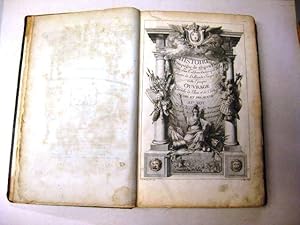
Histoire militaire du duc de Luxembourg . Nouvelle edition plus correcte, & accompagnée des cartes générales du pays. Tome premier - Tome cinquičme; (Segue: [Louis-Bruno Boisgelin de Cucé]. Memoires pour servir a l Histoire du Marechal Duc de Luxemburg)
Verlag: chez Benjamin Gibert, libraire,, 1756
Anbieter: Libreria Antiquaria Pontremoli SRL, Milano, MI, Italien
Bewertung:
Buch
La Haye, chez Benjamin Gibert, libraire, 1756 - 1758, 3 grandi carte geogr. piů volte rip.; ritratto del duca di Luxemburgo in antiporta. Frontespizi in rosso e nero; grandi cap., finalini inc., testatine. Esemplare molto fresco, ottime condizioni. Cfr. FRBNF30121501. 6 voll., in 4° grande, bella legatura in piena pelle mod., dorso a cinque nervi, con titoli e fregi in oro, dentelle anch esse in oro, tagli rossi; piatti con inquadramento a filetto singolo, impresso a freddo, pp. (XVI) 90; (2) 146 (2); (2) 148; (4) 144; (4) 88 (32) con la tavola delle materie; (12) con Advertissement au libraire e Sommaires 132. bella legatura in piena pelle mod., dorso a cinque nervi, con titoli e fregi in oro, dentelle anch esse in oro, tagli rossi; piatti con inquadramento a filetto singolo, impresso a freddo,
-
Histoire de la Campagne de m. Le Prince De Condé, en Flandre en 1674; précédée d'un Tableau Historique de la Guerre de Hollande jusqu'ŕ cette époque: ouvrage enrichi de plans et cartes, dédié et présenté au roi, Par le Chevalier de Beaurain, Géographe de Sa Majesté, et son Pensionnaire.
Anbieter: Antiquariaat A. Kok & Zn. B.V., Amsterdam, Niederlande
Bewertung:
Paris, Chez l'auteur, 1774. XIV,216,(4) pp. Copper-engraved title-page, equestrian portrait, 35 double-page maps depicting maps with dispositions (details handcoloured), 4 large folded maps with colouring in outline, 2 plans and text-illustrations. Original raised & gilt-tooled calf. Folio. - Spine and corners sl. worn; small hole in second title-page; one large folded plan worn / torn along the folds. * Complete.
-

Mappe-Monde dressée sur les Nouvelles découvertes dont les dernieres ont été faites en 1741.
Erscheinungsdatum: 1766
Anbieter: Altea Antique Maps, London, Vereinigtes Königreich
Verbandsmitglied: ABA ILAB PBFA
Bewertung:
Karte
Paris: Louis-Charles Desnos, 1766. Original outline colour. 255 x 340mm. A beautiful small-format map of the world with a remarkable amount of allegorical detail in the borders, including figures of the Four Continents and Apollo in the Chariot of the Sun. Published less than five years before Captain Cook's first voyage, the map shows only partial coastlines for New Zealand and Australia, although the latter has original colour suggesting it is connected to New Guinea and extends considerably tothe east, an unusual feature. In North America the infamous 'Mer de l'Ouest' appears in the north west.
-
Plan de la Ville et du Port Mahon et du Fort St. Philippe.
Verlag: Paris: 1756, 1756
Anbieter: Peter Harrington. ABA/ ILAB., London, Vereinigtes Königreich
Verbandsmitglied: ABA ILAB PBFA
Bewertung:
First state. An uncommon large folding plan of the Port of Mahon and the Fort of St. Philippe on the Balearic Island of Minorca. This plan is engraved in wonderful detail and depth. The island was of great strategic importance during the eighteenth century war between the navies of England and France. Size: 590 x 1180 mm. Copperplate engraving with original outline colour. Printed from two plates - not joined. Margins uncut and minor toning but otherwise in very good condition.
-
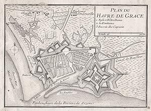
Plan du Havre de Grace" - Le Havre Seine-Maritime Normandie France Plan fortification Fortifikation
Verlag: Paris ca. 1700., 1700
Anbieter: Antiquariat Steffen Völkel GmbH, Seubersdorf, Deutschland
Bewertung:
Kunst / Grafik / Poster
Seltener OriginalKupferstich von ca. 1700. -- Blatt-Format: ca.16 x22 cm. -- knapp beschnitten und alt auf Büttenpapier aufgezogen, sonst gut erhalten. || Rare original copper-engraving from circa 1700. closely cut and mounted on old laid paper, otherwise in good condition. || Rare gravure sur cuivre vers 1700.|| Dies ist ein Original! - Kein Nachdruck! - Keine Kopie! -- This is an original! - No copy! - No reprint! Sprache: Französisch Gewicht in Gramm: 10.
-
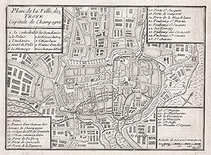
Plan de la Ville de Troye Capitale de Champagne" - Troyes Aube Grand-Est France Plan fortification Fortifikation
Verlag: Paris ca. 1730., 1730
Anbieter: Antiquariat Steffen Völkel GmbH, Seubersdorf, Deutschland
Bewertung:
Kunst / Grafik / Poster
Seltener OriginalKupferstich von ca. 1730. -- Blatt-Format: ca.19 x24,5 cm. -- knapp beschnitten und alt auf Büttenpapier aufgezogen, sonst gut erhalten. || Rare original copper-engraving from circa 1730. closely cut and mounted on old laid paper, otherwise in good condition. || Rare gravure sur cuivre vers 1730.|| Dies ist ein Original! - Kein Nachdruck! - Keine Kopie! -- This is an original! - No copy! - No reprint! Sprache: Französisch Gewicht in Gramm: 10.
-
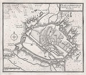
Plan d'Abbeville Capitale du Comté de Ponthieu" - Abbeville Somme Hauts-de-France Plan fortification Fortifikation
Verlag: Paris ca. 1730., 1730
Anbieter: Antiquariat Steffen Völkel GmbH, Seubersdorf, Deutschland
Bewertung:
Kunst / Grafik / Poster
Seltener OriginalKupferstich von ca. 1730. -- Blatt-Format: ca.18,5 x25 cm. -- knapp beschnitten und alt auf Büttenpapier aufgezogen, sonst gut erhalten. || Rare original copper-engraving from circa 1730. closely cut and mounted on old laid paper, otherwise in good condition. || Rare gravure sur cuivre vers 1730.|| Dies ist ein Original! - Kein Nachdruck! - Keine Kopie! -- This is an original! - No copy! - No reprint! Sprache: Französisch Gewicht in Gramm: 10.
-
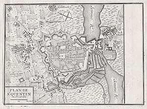
Plan de St. Quentin en Picardie." - Saint-Quentin Aisne Hauts-de-France Plan fortification Fortifikation
Verlag: Paris ca. 1730., 1730
Anbieter: Antiquariat Steffen Völkel GmbH, Seubersdorf, Deutschland
Bewertung:
Kunst / Grafik / Poster
Seltener OriginalKupferstich von ca. 1730. -- Blatt-Format: ca.18 x24 cm. -- gut erhalten. || Rare original copper-engraving from circa 1730. in good condition. || Rare gravure sur cuivre vers 1730.|| Dies ist ein Original! - Kein Nachdruck! - Keine Kopie! -- This is an original! - No copy! - No reprint! Sprache: Französisch Gewicht in Gramm: 10.
-

Plan de la Ville de'Auxonne dans le Duché de Bourgogne" - Auxonne Bourgogne Cote-d'Or France Plan fortification Fortifikation
Verlag: Paris ca. 1730., 1730
Anbieter: Antiquariat Steffen Völkel GmbH, Seubersdorf, Deutschland
Bewertung:
Kunst / Grafik / Poster
Seltener OriginalKupferstich von ca. 1730. -- Blatt-Format: ca.18,5 x24 cm. -- knapp beschnitten und alt auf Büttenpapier aufgezogen, sonst gut erhalten. || Rare original copper-engraving from circa 1730. closely cut and mounted on old laid paper, otherwise in good condition. || Rare gravure sur cuivre vers 1730.|| Dies ist ein Original! - Kein Nachdruck! - Keine Kopie! -- This is an original! - No copy! - No reprint! Sprache: Französisch Gewicht in Gramm: 10.
-
Hardcover. Zustand: very good. Forts de VOORNE & S.ANDRE, 1672, Beaurain anno 1675 Copperengraving, edited by Beaurain, in "Histoire des quatre dernieres campagnes du Marechal de Turenne en 1672,1672,1674 et 1675, enrichie de cartes et de plan topographiques." Printed on thick paper, size of the leaf: 40x45 cm., good print, no cracs.
-

Hardcover. Zustand: very good. Arnhem/Arnheim, siege of 1672, Beaurain anno 1675 Copperengraving, edited by Beaurain, in "Histoire des quatre dernieres campagnes du Marechal de Turenne en 1672,1672,1674 et 1675, enrichie de cartes et de plan topographiques." Printed on thick paper, size of the leaf: 40x45 cm., good print, no cracs.
-
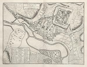
Plan de la Haute et Basse Ville de Boulogne sur Mer. Capitale du Comte Boulonnois." - Boulogne-sur-Mer Pas-de-Calais Hauts-de-France Plan
Verlag: Paris ca. 1720., 1720
Anbieter: Antiquariat Steffen Völkel GmbH, Seubersdorf, Deutschland
Bewertung:
Kunst / Grafik / Poster
Original Kupferstich von ca. 1720. -- Blatt-Maße: ca. 38 x 43 cm. -- gut erhalten. || Original copper engraving from c. 1720. Very rare large plan of the city of Boulogne-sur-Mer. -- in good condition. || Dies ist ein Original! - Kein Nachdruck! - Keine Kopie! -- This is an original! - No copy! - No reprint! Sprache: Französisch.
-

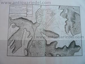
Hardcover. Zustand: very good. Copperengraving, edited by Beaurain, in "Histoire des quatre dernieres campagnes du Marechal de Turenne en 1672,1672,1674 et 1675, enrichie de cartes et de plan topographiques." Printed on thick paper, size of the leaf: 40x45 cm., good print, no cracs.
-

Hardcover. Zustand: very good. Copperengraving, edited by Beaurain, in "Histoire des quatre dernieres campagnes du Marechal de Turenne en 1672,1672,1674 et 1675, enrichie de cartes et de plan topographiques." Printed on thick paper, size of the leaf: 40x45 cm., good print, no cracs.
-
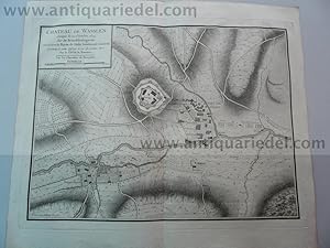
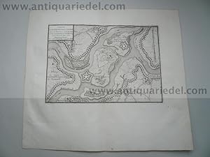
Wasselonne/Wasselnheim, anno 1675, Beaurain-copperengraving
Verlag: Beaurain Jean de, 1696-1771, 1771
Hardcover. Zustand: very good. Copperengraving, edited by Beaurain, in "Histoire des quatre dernieres campagnes du Marechal de Turenne en 1672,1672,1674 et 1675, enrichie de cartes et de plan topographiques." Printed on thick paper, size of the leaf: 40x45 cm., good print, no cracs.
-

Plan des Villes et Chateau de Fribourg" - Freiburg im Breisgau Baden-Württemberg
Verlag: Paris ca. 1730., 1730
Anbieter: Antiquariat Steffen Völkel GmbH, Seubersdorf, Deutschland
Bewertung:
Kunst / Grafik / Poster
Sehr seltener Kupferstich-Plan von Freiburg im Breisgau von ca. 1730. -- Blatt-Maße: ca. 38,5 x 44 cm. -- gut erhalten. || Very rare engraving from c. 1730. -- in good condition. || Grande gravure trčs rare de c. 1730. || Dies ist ein Original! - Kein Nachdruck! - Keine Kopie! -- This is an original! - No copy! - No reprint! print! Sprache: Französisch.
-
Hardcover. Zustand: very good. Copperengraving, edited by Beaurain, in "Histoire des quatre dernieres campagnes du Marechal de Turenne en 1672,1672,1674 et 1675, enrichie de cartes et de plan topographiques." Printed on thick paper, size of the leaf: 40x45 cm., good print, no cracs.
-
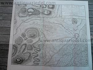
Hardcover. Zustand: very good. Combat de Turckheim/Türkheim, 5.1.1675, Beaurain Copperengraving, edited by Beaurain, in "Histoire des quatre dernieres campagnes du Marechal de Turenne en 1672,1672,1674 et 1675, enrichie de cartes et de plan topographiques." Printed on thick paper, size of the leaf: 51x56 cm., good print, no cracs.