Colorado Trail, Collegiate Loop: 1203 (National Geographic Topographic Map Guide)
Zu dieser ISBN ist aktuell kein Angebot verf�gbar.
Alle Exemplare der Ausgabe mit dieser ISBN anzeigen:
Rese�a del editor:
Biograf�a del autor:
� Waterproof � Tear-Resistant � Topographic Map
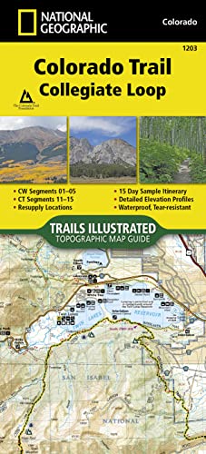
The Colorado Trail, Collegiate Loop Topographic Map Guide has been designed as the perfect traveling companion when navigating the Collegiate Loop section of The Colorado Trail. In 2012, the 83-mile Collegiate West route was added to The Colorado Trail as an alternate route to the Collegiate East section, creating the approximately 163-mile Collegiate Loop.
The Collegiate Loop Topographic Map Guide starts at the top end of the loop near Twin Lakes Reservoir. The trail tracks south along the eastern slope of Sawatch Range under the watchful gaze of several 14ers (fourteen-thousand foot peaks) until it joins the Continental Divide Trail near Monarch. The trail then turns north along the west side of the Sawatch Range as it crisscrosses the continental divide until finally finishing the loop back at Twin Lakes Reservoir. Each page is centered on the trail and overlaps with adjacent pages so there is little chance of getting lost. Along the bottom of each page is a trail profile that shows the distance between passes, camping areas, and trail access points. The map and trail profile provide a step by step visual guide to hiking the trail, mile by rugged mile.
Expertly researched and created in partnership with local land management agencies including The Colorado Trail Foundation, this map guide provides detailed topographic maps, interesting history, a 15 day itinerary, and a resupply location chart shows distances, and services available at each resupply point.
More convenient and easier to use than folded maps, but just as compact and lightweight, National Geographic's Topographic Map Guide booklets are printed on "Backcountry Tough" waterproof, tear-resistant paper with stainless steel staples. A full UTM grid is printed on the map to aid with GPS navigation.
- Map Scale = 1:75,000
- Folded Size = 4.25" x 9.38"
Founded in 1915 as the Cartographic Group, the first division of National Geographic, National Geographic Maps has been responsible for illustrating the world around us through the art and science of mapmaking.Today, National Geographic Maps continues this mission by creating the world's best wall maps, recreation maps, atlases, and globes which inspire people to care about and explore their world.
��ber diesen Titel� kann sich auf eine andere Ausgabe dieses Titels beziehen.
- VerlagNational Geographic Maps
- Erscheinungsdatum2017
- ISBN 10 1566957222
- ISBN 13 9781566957229
- EinbandMapa
- Anzahl der Seiten1
Neu kaufen
Mehr zu diesem Angebot erfahren
EUR 17,94
Versand:
EUR 5,23
Von Vereinigtes K�nigreich nach USA
Beste Suchergebnisse beim ZVAB
Beispielbild f�r diese ISBN
Colorado Trail, Collegiate Loop
ISBN 10: 1566957222
ISBN 13: 9781566957229
Neu
Anzahl: 1
Anbieter:
Bewertung
Buchbeschreibung sheet map (folded). Zustand: New. Language: ENG. Artikel-Nr. 9781566957229
Weitere Informationen zu diesem Verk�ufer | Verk�ufer kontaktieren
Neu kaufen
EUR 17,94
W�hrung umrechnen